Vojteková, J., Vojtek, M., Tirpáková, A. & Vlkolinská, I. Spatial analysis of pottery presence at the former Pobedim Hillfort (an Archeological site in Slovakia). Sustainability 11(23), 6873 (2019).
Tirpáková, A., Vojteková, J., Vojtek, M. & Vlkolinská, I. Using fuzzy logic to analyze the spatial distribution of pottery in unstratified archaeological sites: The case of the Pobedim Hillfort (Slovakia). Land 10(2), 103 (2021).
Holubec, M., Bobáľ, P., Hronček, S., Birošík, F. 2016. Využitie leteckého laserového skenovania pre potreby archeologického prieskumu [The use of aerial laser scanning for the needs of archaeological research]. In GIS Ostrava 2016, 16–18 March 2016, Ostrava. (in Slovak)
Vosselman, G. & Maas, H. G. Airborne and Terrestrial Laser Scanning (CRC Press, Boca Raton, 2010).
Reichstein, M. et al. Deep learning and process understanding for data-driven Earth system science. Nature 566, 195–204 (2019).
Camps-Valls, G., Tuia, D., Zhu, X. X. & Reichstein, M. Deep Learning for the Earth Sciences: A Comprehensive Approach to Remote Sensing, Climate Science, and Geosciences (Wiley, Hoboken, 2021).
Quevedo, R. P. et al. Consideration of spatial heterogeneity in landslide susceptibility mapping using geographical random forest model. Geocarto Int. 37(25), 8190–8213 (2022).
Petrelli, M. Machine Learning for Earth Sciences (Springer, Berlin, 2023).
Mitchell, T. Machine Learning (McGraw Hill, New York, 1997).
Bishop, C. M. Pattern Recognition and Machine Learning (Springer, Berlin, 2006).
Kubat, M. An Introduction to Machine Learning (Springer, Berlin, 2015).
Ramazzotti, M., Buscema, P.M., Massini, G., Della Torre, F. 2019. Encoding and simulating the past. A machine learning approach to the archaeological information. In 2018 IEEE International Conference on Metrology for Archaeology and Cultural Heritage (METROARCHAEO 2018), Cassino, Italy, 39–44. IEEE.
Resler, A., Yeshurun, R., Natalio, F. & Giryes, R. A deep-learning model for predictive archaeology and archaeological community detection. Humanit. Soc. Sci. Commun. 8, 295 (2021).
Fiorucci, M., Verschoof-van der Vaart, W. B., Soleni, P., Le Saux, B. & Traviglia, A. Deep learning for archaeological object detection on LiDAR: New evaluation measures and insights. Remote Sens. 14, 1694 (2022).
Kokalj, Ž et al. Machine learning-ready remote sensing data for Maya archaeology. Sci. Data 10, 55 (2023).
Ruschioni, G., Malchiodi, D., Zanaboni, A. M. & Bonizzoni, L. Supervised learning algorithms as a tool for archaeology: Classification of ceramic samples described by chemical element concentrations. J. Archaeol. Sci. Rep. 49, 103995 (2023).
Wang, Y., Shi, X. & Oguchi, T. Archaeological predictive modeling using machine learning and statistical methods for Japan and China. ISPRS Int. J. Geo-Inf. 12(6), 238 (2023).
Albrecht, C. M., Fisher, C., Freitag, M., Hamann, H. F., Pankanti, S., Pezzutti, F. & Rossi, F. 2020. Learning and recognizing archeological features from LiDAR Data. 2019 IEEE International Conference on Big Data (Big Data).
Oonk, S. & Spijker, J. A supervised machine-learning approach towards geochemical predictive modelling in archaeology. J. Archaeol. Sci. 59, 80–88 (2015).
Zhao, Q. Research on the identification and application of immovable cultural relics in the historic city of Macau based on condition of intelligent remote sensing technology. Wirel. Commun. Mob. Comput. 2021, 66432–66432 (2021).
Yuan, M. & McKee, A. Embedding scale: new thinking of scale in machine learning and geographic representation. J. Geograph. Syst. 24, 501–524 (2022).
Fernandez-Diaz, J. C., Carter, W. E., Shrestha, R. L. & Glennie, C. L. Now You See It… Now You Don’t: Understanding Airborne Mapping LiDAR collection and data product generation for archaeological research in Mesoamerica. Remote Sens. 6(10), 9951–10001 (2014).
Witharana, C., Ouimet, W. B. & Johnson, K. M. Using LiDAR and GEOBIA for automated extraction of eighteenth–late nineteenth century relict charcoal hearths in southern New England. GIScience Remote Sens. 55(2), 183–204 (2018).
Ninfo, A., Mozzi, P. & Abbà, T. Integration of LiDAR and cropmark remote sensing for the study of fluvial and anthropogenic landforms in the Brenta-Bacchiglione alluvial plain (NE Italy). Geomorphology 260, 64–78 (2016).
Balsi, M., Esposito, S., Fallavollita, P., Melis, M. G. & Milanese, M. Preliminary archeological site survey by UAV-Borne Lidar: A case study. Remote Sens. 13(3), 332 (2021).
Qiu, J., Ding, G., Xu, Y. & Feng, S. A survey of machine learning for big data processing. EURASIP J. Adv. Signal Process. 2016, 67 (2016).
Carter, A. B. et al. A spatial analysis of seagrass habitat and community diversity in the Great Barrier Reef World Heritage Area. Sci. Rep. 11(1), 22344 (2021).
Liu, S., Liu, R. & Tan, N. A spatial improved-kNN-based flood inundation risk framework for urban tourism under two rainfall scenarios. Sustainability 13(5), 2859 (2021).
Mehta, S., Kukreja, V. & Gupta, A. 2023. Exploring the efficacy of CNN and SVM models for automated damage severity classification in heritage buildings. In 2023 Second International Conference on Augmented Intelligence and Sustainable Systems (ICAISS), 252–257, IEEE.
Breiman, L. Random forests. Mach. Learn. 45, 5–32 (2001).
Belgiu, M. & Drăguţ, L. Random forest in remote sensing: A review of applications and future directions. ISPRS J. Photogramm. Remote Sens. 114, 24–31 (2016).
Zhang, S., Li, X., Zong, M., Zhu, X. & Cheng, D. Learning k for knn classification. ACM Trans. Intell. Syst. Technol. 8(3), 1–19 (2017).
Patle, A. & Chouhan, D. S. 2013. SVM kernel functions for classification. In 2013 International Conference on Advances in Technology and Engineering (ICATE), 23–25 January 2013, Mumbai, India. IEEE.
Cheben, I. & Daňová, K. 2023. Archeologické výskumy a nálezy na Slovensku v roku 2017 [Archaeological research and finds in Slovakia in 2017]. VEDA. (in Slovak)
Beljak Pažinová, N. & Beljak, J. Benefits of the long-term research into the Pustý hrad castle (Deserted castle) in Zvolen and its prospects for the future. Archaeol. Hist. 45(2), 941–956 (2020).
Slamova, M., Belacek, B., Beljak, J., Pazinova, N. & Chudy, F. Dependence of the medieval settlements and historical roads to the natural environment around the deserted castle in Zvolen (Slovakia). Procedia Soc. Behav. Sci. 120(19), 213–223 (2014).
Greif, V. & Vlčko, J. Key block theory application for rock slope stability analysis in the foundations of medieval castles in Slovakia. J. Cult. Herit. 14(4), 359–364 (2013).
Maliniak, P. 2021. Úvod do štúdia dejín stredovekých hradov [Introduction to the study of the history of medieval castles]. Belianum. (in Slovak)
Leitmanová, K., Gálová, L., Lieskovský, T., Bisták, P. & Zachar, J. Projekt leteckého laserového skenovania Slovenskej republiky a jeho využitie v manažmente ochrany archeologického dedičstva [Airborne Laser Scanning Project of the Slovak Republic and its Use in the Management of Archaeological Heritage Protection]. Geodetický a kartografický obzor 68(3), 53–68 (2022) (in Slovak).
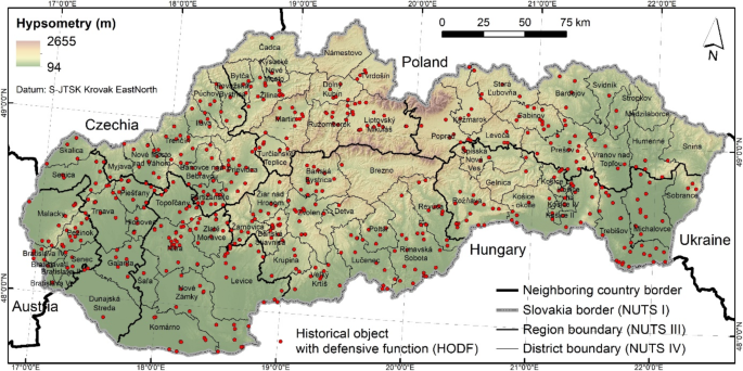
Vojteková, J., Tirpáková, A., Petrovič, F., Izakovičová, Z. & Vojtek, M. Spatial analysis of historical objects with defensive function in Slovakia. Geocarto Int. 37(25), 7556–7579 (2022).
Liščák, P. 2017. Map of Engineering Geological Zones, scale 1:50,000. State Geological Institute of Dionýz Štúra.
Miklós, L. et al. 2006. Atlas reprezentatívnych geoekosystémov Slovenska [Atlas of representative geoecosystems of Slovakia]. Ústav krajinnej ekológie SAV. (in Slovak)
Suthaharan, S. Support vector machine. In Machine Learning Models and Algorithms for Big Data Classification: Thinking with Examples for Effective Learning 207–235 (Springer, Berlin, 2016).
Pisner, D. A. & Schnyer, D. M. Support vector machine. In Machine Learning 101–121 (Academic Press, Cambridge, 2020).
Steinwart, I. & Christmann, A. Support Vector Machines (Springer, Berlin, 2008).
Peterson, L. E. K-nearest neighbor. Scholarpedia 4(2), 1883 (2009).
Zhang, Z. Introduction to machine learning: k-nearest neighbors. Ann. Transl. Med. 4(11), 218 (2016).
Steinbach, M. & Tan, P. N. kNN: k-nearest neighbors. In The Top Ten Algorithms in Data Mining 165–176 (Chapman and Hall/CRC, Boca Raton, 2009).
Biau, G. & Scornet, E. A random forest guided tour. Test 25, 197–227 (2016).
Cutler, A., Cutler, D.R., Stevens, J.R. 2012. Random forests. Ensemble machine learning: Methods and applications, 157–175.
Fan, J., Upadhye, S. & Worster, A. Understanding receiver operating characteristic (ROC) curves. Can. J. Emergency Med. 8(1), 19–20 (2006).
Yang, S. & Berdine, G. The receiver operating characteristic (ROC) curve. Southwest Respir. Crit. Care Chron. 5(19), 34–36 (2017).
Pepe, M. S. Receiver operating characteristic methodology. J. Am. Stat. Assoc. 95(449), 308–311 (2000).
Hanley, J.A. 2014. Receiver operating characteristic (ROC) curves. Wiley StatsRef: Statistics Reference Online.
Huang, N., Lu, G. & Xu, D. A permutation importance-based feature selection method for short-term electricity load forecasting using random forest. Energies 9(10), 767 (2016).
Kaneko, H. Cross-validated permutation feature importance considering correlation between features. Anal. Sci. Adv. 3(9–10), 278–287 (2022).
Majerčíková, D. Nálezy púchovskej kultúry na Kysuciach [Finds of the Púchov culture in Kysucie]. Kysucký múzejník 3(1), 4–11 (2022) ((in Slovak)).
Polla, B., Slivka, M. & Vallašek, A. K problematike výskumu hrádkov a hradov na Slovensku [On the issue of research on castles in Slovakia]. Archaeol. Hist. 6(1), 361–405 (1981).
Roccetti, M., Delnevo, G., Casini, L. & Salomoni, P. A cautionary tale for machine learning design: Why we still need human-assisted big data analysis. Mob. Netw. Appl. 25, 1075–1083 (2020).
Belayneh, A., Adamowski, J., Khalil, B. & Quilty, J. Coupling machine learning methods with wavelet transforms and the bootstrap and boosting ensemble approaches for drought prediction. Atmos. Res. 172, 37–47 (2016).
Kalantar, B. et al. Forest fire susceptibility prediction based on machine learning models with resampling algorithms on remote sensing data. Remote Sens. 12(22), 3682 (2020).