SATURDAY NIGHT UPDATE
Much of Saturday has been characterized by freezing drizzle, freezing fog & or freezing rain. Ice accretion with the appetizer & been greater than model guidance which doesn’t bode well for the rest of the storm. I have a sneaking suspicion that South Central KS might end up with a rough icing event. It’s very possible that excessive mixed phase precipitation could eat into snow production & lower snow totals locally.

Winter Storm Warnings remain in effect for much of KAKEland however we now have Blizzard Warnings for Central into NE KS Sunday 3am-6pm. Not overly surprising, the wind field as this Low wraps up is quite impressive.
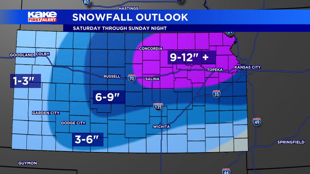
Despite the increased chance of icing, possibly up to a 1/2″ in South Central & Wichita. Northern into NE KS will likely experience the worst of this winter storm in terms of heavy snowfall & blowing snow. Models continue to hint that the snow maxima MAY shift more N/NE. Regardless heavy snow looks possible for much of North Central into NE KS especially near deformation zones.
If we think back to initial ice estimates, max values were around 1/4″ which is still impactful but due to latest trends favoring ice accretion. Greater ice amounts look very possible in South Central KS including Wichita. IF Wichita were to get 1/2″+ of ice that would easily lead to power outages & an ice rink. Hopefully we change over to snow sooner than forecast, that would alleviate the ice threat. Alas the warm nose or warm air aloft causing all the freezing rain is far from eroded.
Timeline remains the same, only key difference is that Wichita & South Central MAY stick with freezing rain/sleet more so than snow possibly until early Sunday morning. The longer we stay with mixed phase precipitation, the more likely it will impact our snow totals.
Travel is highly discouraged this weekend, it’s already a mess & expect to get much worse late tonight through Sunday.
The first winter storm of the season is taking aim at KAKEland this weekend.
Rain, ice and snow are all possible beginning Saturday afternoon. Light ice and/or sleet will be possible in central Kansas to start with a transition to snow overnight Saturday. Snow lingers through the day Sunday before clearing out late.
See KAKE’s Interactive Radar here
We WILL have snow accumulation, mainly across central Kansas, but how much is still the question.
Impacts will be greatest late Saturday night and through the day Sunday. Travel should be limited. Winds will be breezy across the state Sunday leading to dangerous wind chill values, but also could lead to blizzard-like conditions with limited visibility as snow is falling.
Watch the latest forecast videos here
Much colder air filters in Sunday and lingers into the workweek with highs in the 20s and overnight lows in the single digits, but wind chill values will remain dangerously low for several mornings in a row.
Wichita Mayor Lily Wu said Thursday that the city has 6,000 tons of sand/salt mix on hand and 10,000 tons of salt in reserve. The city focuses its road treatment efforts on emergency routes, roads that serve hospitals, ect. Wichita does not treat roadways like Kellogg, I-135, I-235 and K-96. The Kansas Department of Transportation takes care of those roadways.
The Wichita Police Department’s Homeless Outreach Team is connecting unhoused people with shelter services.
Remember to stay on top of the weather with the KAKE First Alert Weather App! You can track road conditions and view traffic cameras at KanDrive.org.
AAA Kansas tips to prepare vehicles for winter weatherMake certain your tires have good tread for adequate traction and are properly inflated. For every 10-degree drop in temperature, tires can lose 1 pound of air pressure.Have the battery checked by a professional to ensure it is strong enough to face cold weather. When the air temperature is 32 degrees, a battery’s starting power drops 35% and at 0 degrees outside, battery starting power in 60% lower than normal. Also, the average lifespan of a car battery is 3-5 years. AAA members can request a visit from a AAA mobile battery service technician who will test their battery and replace it on-site, if necessary.Keep your gas tank at least half-full to avoid gas line freeze-up.Ensure that windshield wiper blades are in good condition and the wiper fluid reservoir is full. A winter blend of wiper fluid that resists freezing is recommended.Make sure all lights (headlights, tail and brake lights, turn signals) are working properly so you can see and be seen in bad weather conditions.
FRIDAY EVENING UPDATE
WICHITA, Kan. (KAKE) – This weekend is looking rough as we experience our first major winter storm of the season. The storm responsible for this event is almost onshore but still over 1500 miles away from Wichita. Keep in mind, minor fluctuations of the track of the Low can greatly change the outcome.
Much of KAKEland is now under a Winter Storm Warning, the worst of the snow will still likely fall across North Central into NE KS.
South Central KS including Wichita will still likely see snowfall but our main concern revolves around prolonged freezing drizzle & freezing rain. We could easily see icing problems.
TIMELINE
Much of the area on Saturday will be cloudy with spotty drizzle, rain showers, freezing drizzle, freezing rain or sleet. Conditions will slowly get worse as the day progresses.
Conditions will continue to deteriorate by Saturday 10PM, freezing precipitation coverage will increase. Far Northern KS, will start to notice snow banding develop. Meanwhile down by the KS/OK line, rain showers will be possible.
Overnight we will finally see this winter storm take shape with a rain near the KS/OK line, freezing rain/sleet over West into Central KS. Finally heavier snow banding across Northern KS.
By Sunday morning, snow banding will start to overtake more of KAKEland due to cold air wrapping around the backside of the Low. Freezing precipitation could still be possible across South Central KS.
By Sunday afternoon, snow banding will be draped across the state. Heaviest snow banding will be across Northern into NE KS.
The storm system will finally slide East of KAKEland by late Sunday night.
Keep in mind, this is a rough outlook based on the latest numerical model data. IF the Low’s path shifts any direction, the forecast will dramatically change.
If you are not comfortable driving in wintry weather, I would not advise against not traveling this weekend. Travel issues may persist through early next week due to being trapped in an arctic air mass.
Stay tuned for updates.
There has not been much change in the forecast for this weekend’s impending winter storm.
Several inches of snow is still possible across KAKEland. Spotty, light showers start early Saturday morning with some light freezing drizzle. Heavier precipitation moves in late Saturday night, and eventually transitioning to snow by early Sunday morning.
The biggest concern right now is the possibility for freezing rain accumulation, anywhere from a glaze to a quarter of an inch, which will cause travel concerns as well as the possibility for some power outages.
Cold air moves in behind this system with highs in the teens and 20s by Monday with dangerous, sub-zero wind chill values.
Previous update (January 2):
Confidence is increasing regarding our winter storm this weekend. However a lot of uncertainty remains when it comes to accurate snow totals & ice accretion. Alas the storm system is still over 600 miles offshore. The forecast will likely continue to evolve.
Let’s talk about snow totals. As of right now, the heaviest snow looks possible across North Central but more so NE KS. North Central KAKEland could see 4-8″ of snow. South Central KS including Wichita will be more so in the mix so icing will be more of a problem.
Prior to the snow, freezing drizzle, freezing rain & sleet will be the main precipitation type. This will likely lead to icing problems especially if prolonged. Keep in mind it takes very little ice to become a big problem. Typically we get really concerned when ice accretion is over 1/4″.
Traveling Saturday through Monday is not advised especially if you don’t like winter weather driving.
The forecast is expected to change, stay tuned for updates.