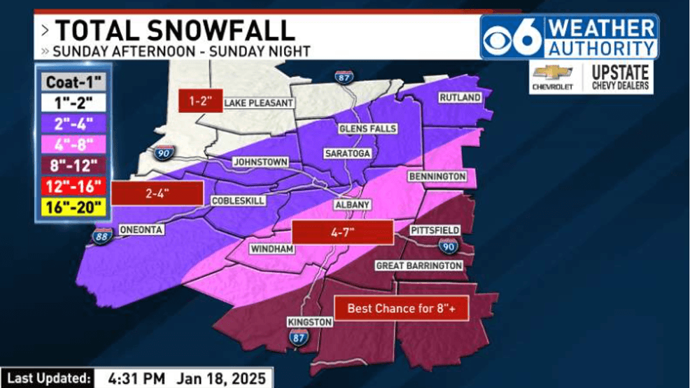
A low pressure wave will form over the Southeastern U.S. and move northward and pass east of Long Island and the New England coast Sunday night. The system will be a fast mover, so snowfall amounts are expected to be of a moderate amount for the Capital Region, with lighter amounts as you move farther to the north and west.
Highest snowfall totals will likely be in areas just east and south of Albany. You can click on our snowfall projection map below to see the latest projections. The snow will begin to taper off as we move beyond midnight and into the early morning hours of Monday with dry conditions expected by sunrise. In the wake of the departing storm, the coldest air of the season so far will settle over the region into the first half of next week, Mostly dry weather is expected through this period other than a few lake effect snow showers possible in spots on Monday, mainly in areas to the west and northwest. Slow temperature moderation is anticipated for the latter part of the week, with readings moderating a little, but with no significant warm-ups are in the forecast. Both Thursday and Friday are also looking to be mainly dry at this point, although some flurries are not our of the question on Friday with the approach of a weak upper level disturbance.
Keep it tuned for more updates.