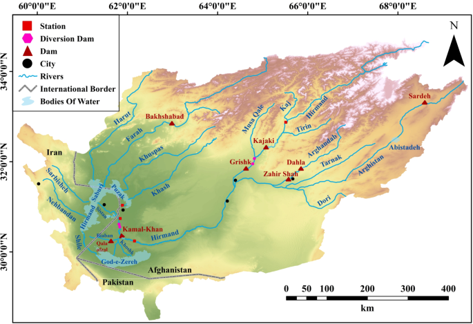
Table 1 shows the net changes (km2) of each LULC type period: 2000–2020, 2010–2020, and 2000–2020. Figure 4 illustrates the LULC loss and gain during 2000–2020, with the primary change being the conversion of barren pasture into cultivated land. In 2000, when the Taliban took power, water flow to Iran was completely halted, leading to the drying up of the Hamoun wetlands and Goud-e-Zereh depression. However, during the 2000–2020 period, there was an shrinkage in wetland areas due to a reduction in the water reaching Hamoun Lakes, although this situation reversed briefly in 2019 when heavy rains and flooding resulted in the temporary drainage of the wetlands as floodwaters were released toward Iran. Urbanization was another significant trend over these two decades, with built-up areas expanding by 174%, largely due to population growth and urban development, particularly in Lashkargah, where the Arghandab and Hirmand rivers converge. In contrast, pasture areas decreased by 45%, often being converted to barren land, which saw a 72% increase. This trend, however, may be temporary, likely due to insufficient precipitation in recent years.
Land use and land cover loss during 2000–2020. (a) LULC loss and (b) LULC gain (Prepared in QGIS 3.38.3).
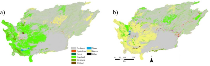
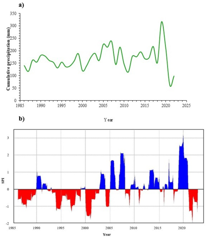
Temporal changes of precipitation in Hirmand Basin
Figure 5 illustrates the cumulative precipitation in three sub-basins from 1981 to 2022, as measured by CHIRPS. Throughout this 42-year period, rainfall exhibited significant fluctuations but showed an overall upward trend. The highest recorded rainfall occurred in 2019, with 348 mm, leading to a major flood that year. In contrast, 2021 saw the lowest rainfall at just 97 mm. The average annual rainfall over this period was 184 mm, with a standard deviation of 53 mm. Using the SPI index, which classifies precipitation into wet (1 to 0) and dry (0 to − 1) periods, it was found that over 70% of the years from 1986 to 2022 experienced normal climatic conditions. Dry conditions were observed in only five years (11%), while three years (2005, 2007, and 2020) experienced notably wet conditions. Notably, 2019 was categorized as a highly wet year based on the SPI index (Fig. 5).
(a) Annual precipitation in the three sub-basins of Hirmand, Arghandab, and Dehravod between 1986 and 2022. (b) Dry and wet years during 1987–2022 for the Hirmand basin (in three sub-basins of Hirmand, Arghandab, and Dehravod).
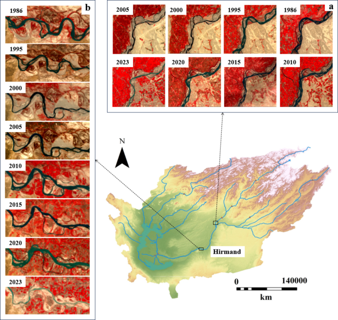
Morphological changes in the Hirmand Transboundary River
The Landsat datasets (e.g., Landsat 5, 7, and 8) provided temporal coverage from 1986 to 2023, capturing changes in the river’s structure over several decades. Our analysis identified 87 arcs in the river between 1987 and 2020. As the river flowed toward the plain, both the sinuosity coefficient and average width increased. his pattern aligns with Frasson’s findings on the Amazon River and its tributaries56. However, over time, both the sinuosity coefficient and average width began to decline. Figure 6 shows the median curvature coefficient and average width of the curvatures at five-year intervals. During the studied period, the river’s width decreased by an average of 3 m annually. The predominant curvature types throughout the study were “meander” and “highly meander,” as detailed in Table 2. The highest curvature coefficient occurred in 2003 (4.57), while the lowest, excluding 2008, was 1.4. Downstream of the Kajaki Dam, tributaries decreased due to reduced flow and sediment, a trend consistent with Nelson’s research on the Jackson Dam in the Snake River57. According to Brice’s classification58, the primary changes in the river’s sinuous form included arch shortening, rotation, and expansion (Fig. 7). These changes were observed in two selected curves, whose alterations from 1986 to 2022 are illustrated in the figure.
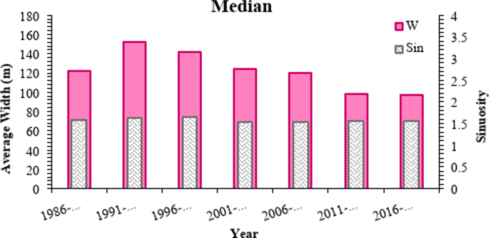
The mean sinuosity coefficient and average width of curves of the Hirmand River in a 30-year period from downstream of the Kajaki dam to the end.
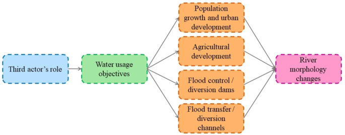
The trend of relationships of one of the influencing factors (Third actor’s role) on the change of river morphology.
The study also examined the lateral migration of the river’s arcs from 1986 to 2022. Of the 87 arcs, six (7%) showed no significant movement, while nine (10%) moved less than 200 m. Thirty-five arcs (40%) experienced displacements between 200 and 500 m, 28 arcs (32%) moved between 500 and 1000 m, and seven arcs (8%) moved between 1000 and 1200 m. Arcs 64 and 73 exhibited the highest displacement rates, exceeding 1200 m. A comparison of Figs. 6 and 8 revealed an unexpected reduction in the river’s width during periods of floods and above-average rainfall. This phenomenon was likely influenced by several factors, including the expansion of cultivated areas and the accumulation of water in dam reservoirs.
Changes in two curves of the Hirmand River in 36 years. (a) Shows the development of a curve and its shortcut form, and (b) shows the process of the disappearance of one curve and the emergence of another curve over time (Prepared in QGIS 3.38.3).
The course of water vicissitudes between Iran and Afghanistan
In 1857, Afghanistan officially separated from Iran under the pressure of Great Britain, based on the Paris treaty. In 1872, the British Commissioner’s arbitration marked the most variable part of the Hirmand River as the border between the two countries59. A significant flood in 1896 altered the course of the river, and the new course was established as the border in 1905 due to the ongoing border dispute60. The development of the Hirmand Valley began in 1910, supported by financial aid from several foreign countries, including Germany, Japan, the United States, India, and Turkey, each with their own geopolitical interests61. However, this development has led to reduced water flow to Iran, at times completely severing the flow61. The 1973 Helmand River Treaty, which governs the distribution of water between the two countries, remains central to these disputes. Iran contends that the treaty does not account for the current environmental and agricultural demands, while Afghanistan asserts its right to develop upstream resources independently62. One of the main points of contention has been the construction of dams, such as Kamal Khan, which have significantly reduced the water available for Iran, particularly affecting the Hamoun wetlands. The 1973 treaty set the flow rate of the Hirmand River at 26 cubic meters per second, a figure that is far below the environmental requirements of Hamoun Lake62. Under the treaty, Iran’s water rights amount to only 14% of the river’s flow, primarily for drinking and irrigation, while the water rights of the Hamoun wetlands were overlooked63. In 1996, with the rise of the Taliban, the Hirmand River’s flow to Iran was completely cut off, causing Hamoun Lake to dry up. Following the completion of the Kamal Khan Dam in 2022, excess water from the dam was diverted to the Qala Afzal dam and Goud-e-Zereh depression. This development, alongside the construction of an irrigation and drainage network, aims to transform 49,000 hectares of previously uninhabited desert into agricultural land, benefiting 49,000 families (Afghanistan Ministry of Water and Energy, 1400). Figures A1–A3 in the appendix summarize key water-related issues between Iran and Afghanistan from 1857 to 2022. These diagrams provide an overview of how successive governments have addressed water matters, offering a detailed perspective on the evolution of water conflicts and developments between the two nations.
TWINS’ matrix of water interactions between Iran and Afghanistan on the Hirmand Transboundary River
Table 3 summarizes the water relations between Iran and Afghanistan over the transboundary Hirmand River, detailing the levels of cooperation and conflict between the two countries from 1986 to 2022, as analyzed using the TWINS correlation matrix. Unlike previous studies by Nagheeby and Warner64, which focused primarily on hydrological data, this paper also examines the environmental impacts and morphological changes of the river. According to the matrix, the level of conflict between Iran and Afghanistan regarding the Hirmand River water issues has primarily been categorized as security/opportunity. During the Taliban era (1996–2001), conflict intensified due to the closure of the Kajaki Dam, the drying of Hamoun Lake. However, from 2011 to 2021, despite Iran’s support for Afghanistan’s reconstruction, the water relations between the two countries were viewed more as an opportunity. During this period, Iran facilitated a media space and accelerated construction in the HTRB, allowing Afghanistan to attract foreign capital and promote development in the Hirmand Valley. This period of cooperation helped avoid direct water disputes, although the 1973 Helmand River Treaty’s failure to address the environmental requirements of Hamoun Lakes remained a significant issue. The treaty continues to guide Afghanistan’s water resource planning, but it only addresses irrigation and drinking water needs, leaving the Hamoun wetlands largely neglected. Table 4 shows that the cooperation level between Iran and Afghanistan has generally remained at the third level, reflecting the absence of a shared norm or collective identity. The lowest level of cooperation occurred in five intervals (Periods 1, 2, 3, 8, and 9), while two intervals (Periods 6 and 7) achieved the second level of cooperation. Only in the fourth and fifth periods did the two countries align their goals regarding the Hirmand River, with cooperation increasing during these years. Despite this, the most intense conflicts occurred during four key periods, particularly during Periods 3 and 9, driven by security concerns and disputes over new infrastructure projects like the Kamal Khan Dam, as well as opportunistic motives during Periods 6 and 7. The first two periods reflect a neutral stance in hydropolitical relations, while Periods 3 and 9 marked the lowest level of cooperation, with the highest levels of dispute over the Hirmand River. The conflicts during these times were exacerbated by disputes over the 1973 treaty’s terms, particularly regarding Afghanistan’s unilateral development of water resources and the construction of dams. These developments led to environmental degradation downstream, affecting Iran’s agricultural output and public health. Conversely, the sixth and seventh periods saw a shift toward more favorable interactions, with reduced conflict and increased cooperation. This was largely due to Afghanistan’s hydraulic mission and development-focused planning, which emphasized the Hirmand Valley’s integration into broader national development projects. The involvement of foreign investors in upstream water and agricultural projects further contributed to a more cooperative atmosphere. Overall, the fluctuations in conflict and cooperation observed in the TWINS matrix reflect the influence of key geopolitical events, infrastructure developments, and diplomatic efforts. Periods of heightened conflict often correlate with upstream activities, such as dam constructions, while periods of increased cooperation are typically associated with diplomatic negotiations and partial agreements on transboundary water management. These dynamics underscore the complex nature of hydropolitical interactions, where conflict and cooperation are shaped by a combination of political, environmental, and developmental factors.
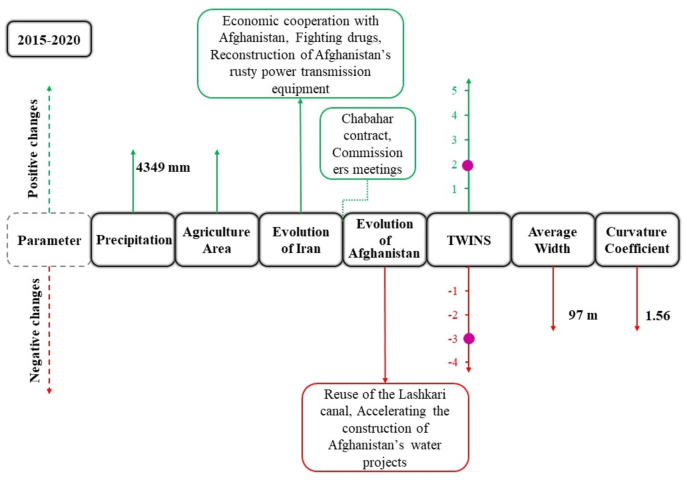
As mentioned, our analysis was divided into five-year periods, each focusing on various factors such as rainfall, LULC changes, geopolitical developments, cooperation and conflict levels, and morphological shifts. For the period between 2015 and 2020, Fig. 9 provides a summary of the key findings. This period was marked by exceptionally wet conditions, with total precipitation reaching 4349 mm, as indicated by the SPI index. Alongside this, significant LULC changes occurred, notably the expansion of cultivated areas, as shown in the LULC maps. Geopolitically, this period saw the signing of the Chabahar Agreement between Iran, Afghanistan, and India, which facilitated regional cooperation. Under this agreement, Iran allowed India to use its strategic port, improving the transit of goods to Afghanistan. Iran also took part in the reconstruction of Afghanistan’s electricity transmission infrastructure, further contributing to bilateral cooperation. Despite these positive developments, the water relations between Iran and Afghanistan were complicated by Afghanistan’s political decisions as an upstream nation. In this period, Afghanistan diverted water from the Lashkari Stream, redirecting a significant volume (900 million m3) of river water to Zaranj and surrounding areas. This action, though part of Afghanistan’s national development strategy, placed the water relations between the two countries within the cooperation matrix at the level of joint action and opportunity creation. However, despite the increased rainfall during this period, the water flow into Iran was significantly reduced due to these upstream interventions. As a result of these water diversions, the Hirmand River’s width decreased to just 90 m, indicating a significant change in its morphology. This demonstrates how Afghanistan’s upstream water management decisions can have a profound impact on the downstream flow and river morphology, even in a period of above-average rainfall. Overall, while this period was characterized by some positive geopolitical developments and increased rainfall, the hydropolitical dynamics, especially Afghanistan’s diversion of water, led to a reduction in the river flow to Iran and changes in river morphology, highlighting the complex relationship between climatic factors and political decisions in transboundary water management.
Summary of the natural-human transformations that have occurred in the transboundary basin of Hirmand.
Entanglement of natural and human factors in river morphology change
A thorough examination of the HTRB through the lens of spatiotemporal analysis has illuminated the complex interplay of factors influencing the morphological transformations of the Hirmand River. Through the investigation of precipitation trends, LULC changes, and the historical intricacies of water politics, we have parsed out the direct and indirect drivers of the river’s shifting morphology, as depicted in Fig. 7. This multifaceted exploration spanned both tangible, physical aspects and the nuanced, often elusive, realm of hydropolitics, each influencing river morphology in distinct yet interconnected ways. On the physical plane, the observable impacts on the HTRB stem from an array of hydrological and anthropogenic elements. The construction of infrastructures and diversion dams, the establishment of water transfer and diversion channels, and the progression of agricultural ventures, particularly in the Faryab region, have been identified as pivotal factors. These, along with the vicissitudes of riparian vegetation, burgeoning population densities, and sprawling urban landscapes, act as primary agents of change, exerting a forceful influence on water flow dynamics and sediment transport mechanisms. The resultant alterations reverberate through the river’s course, inducing significant morphological shifts. Intricate feedback loops further complicate these dynamics: as urban areas expand, so too does the imperative for intensified agricultural output, which in turn necessitates augmented water diversion and flood control measures.
Further, the hydro-engineering structures themselves alter the sediment regime, potentially exacerbating riverbank erosion and altering riparian ecosystems. This cascade of physical changes not only impacts the river’s morphology but also influences the hydrological character and ecological integrity of the entire basin. Understanding of these complex interactions is critical, informing both conservation strategies and infrastructural development. Transitioning to the hydropolitical stratum, the canvas broadens, encapsulating national and international vectors that shape the river’s governance. Within Afghanistan’s borders, an intricate tapestry of economic, ethnic, and political threads weaves a complex pattern of water management approaches and nationalization efforts. Each thread bears a distinct influence: from the crafting of water usage policies to the integration of ethnic and economic considerations into the national discourse on water rights and distribution. These national initiatives, in turn, engage with and adapt to the flux of international negotiations, treaties, and the broader geopolitics of water.
Our analysis also casts light on the global stage, where Afghanistan’s hydrological stance and its international engagements play out. The intricate dance of diplomacy is most pronounced in the interdependencies between Afghanistan and Iran, where shared water resources necessitate reciprocal engagement and mutual interests. This dyadic interaction is underpinned by formal treaties and colored by the geopolitical interests of third-party nations whose involvement brings additional layers of complexity and strategic maneuvering to the table. Amidst these international dialogues, the roles assumed by countries like Britain, the United States, and India emerge as particularly influential, each with its geopolitical agenda and benefits that impact on regional water politics. Their involvement often skews the hydrological partnership, imposing a unidirectional flow of influence rather than a synergistic exchange. Collectively, these relations highlight the river’s vulnerability to numerous influences, as human interventions and natural phenomena are interwoven in a complex pattern of causality and consequence. Understanding this is vital, as it shapes not only the physical landscape of the HTRB but also the sociopolitical tapestry that will determine the future of water distribution, usage, and conservation within the region.
Moreover, the relationships among the parameters extend beyond their respective categories. For instance, the involvement of a third actor in the international category can impact Afghanistan’s water usage objectives in the national category. Similarly, management policies at the hydropolitical level can influence the presence of water control/diversion dams at the physical level. Each parameter identified in this complex pattern has the capacity to influence changes in river morphology, highlighting a network of factors including population growth, urban development, water usage objectives, management policies, and the hydropolitical relations between Iran and Afghanistan, as well as Afghanistan’s perspective on water and its utilization (Fig. 10). This illustration underscores the significant impact these parameters can have on the river’s form and flow, which, in turn, play a critical role in shaping the broader environmental and socio-political landscape within the HTRB.
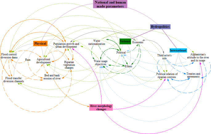
Complex pattern of influencing factors on change in the morphology of Hirmand transboundary river.
Environmental consequences of water developments in Iran and Afghanistan
After the main artery of the Hirmand River was severed in 1996, a prolonged drought began in the Hamoun International Wetlands and the Sistan region of Iran, both designated as Ramsar Convention sites in 1971. By 1998, Hamoun Lake had completely dried up, exacerbating the disruption. This not only affected the livelihoods of the residents in the Sistan region but also led to the destruction of the ecosystem associated with the Hamoun wetlands. Over the past few decades, the Hamoun area has experienced significant environmental fluctuations due to climate change and poor riparian management practices. Following the complete desiccation of Hamoun Lake in 1998, occasional seasonal floods temporarily relieved the area. However, the lake’s complete desiccation posed a significant threat to the livelihoods of Sistan residents, whose main occupations included animal husbandry, agriculture, fishing, and mat weaving. The drying of Hamoun Lake not only disrupted local livelihoods but also diminished its role as a windbreak against the region’s 120-day solid winds, reducing it to a small spring. As a result, the onset of these winds and sandstorms caused severe problems, prompting significant migration from the area. The environmental consequences were devastating. The Sistani cow, a breed with over 5,000 years of history, is now on the brink of extinction, with only around 200 individuals remaining. The habitat of the Iranian leopard is disappearing, and the number of migratory birds wintering in Hamoun Lake has dwindled to zero due to prolonged droughts and habitat destruction. Figure 11 illustrates the changes in the region’s ecosystem. These environmental consequences are deeply intertwined with hydropolitical tensions, as Iran has repeatedly attributed the drying of the wetlands and resulting socio-economic disruptions to upstream water management practices in Afghanistan, including dam construction and water diversion projects. The socio-economic impacts of hydrological and morphological changes in the Hirmand Basin have been profound. Reduced water availability and wetland degradation have forced local populations to migrate, disrupting community structures and economic stability. The decline in agricultural productivity, coupled with water scarcity, has caused significant economic losses, deepening poverty and food insecurity in downstream regions. Furthermore, the desiccation of the Hamoun wetlands has led to more frequent and severe dust storms, adversely affecting public health and increasing healthcare costs.
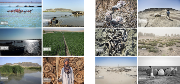
Environmental impacts of the reduction and interruption of the Hirmand flow on the drying of Hamoun Lake and the downstream parts of the basin; the left panel shows the conditions before the drying of Hamoun, and the right panel shows the chaotic situation in the Sistan region after the drought in 2001 (adopted from https://www.irna.ir/).
External actors, including international governments and NGOs, play a crucial role in shaping hydropolitical relations in transboundary basins like the Hirmand Basin. International agencies can mediate disputes, provide technical expertise for joint water management, and fund sustainable projects. NGOs facilitate dialogue and ensure marginalized communities are included in decision-making. In the Hirmand Basin, such cooperation could involve ensuring compliance with the 1973 Helmand River Treaty or funding environmental restoration of the Hamoun wetlands. These interventions can help alleviate tensions and promote equitable resource sharing. Similar dynamics have been observed in other transboundary basins, where external actors have facilitated cooperation. For example, in the Nile Basin, international organizations supported multi-stakeholder dialogues to address water-sharing concerns through initiatives like the Nile Basin Initiative (NBI), established in 1999. The NBI, backed by international agencies, provides a platform for dialogue, information sharing, and joint planning among riparian countries, promoting sustainable management and equitable water use. Applying such models to the Hirmand Basin could offer pathways for conflict resolution and sustainable management.
Integrated analysis of transboundary river dynamics in the HTRB
Transboundary river dynamics are shaped by the interplay of natural, anthropogenic, and geopolitical factors. This study integrates morphological changes, LULC patterns, precipitation variability, and historical water relations to develop a framework for analyzing the Hirmand Basin’s dynamics and challenges. It specifically examines how relocation of governments and upstream activities, such as dam construction and water diversions, alter river morphology and intensify downstream water disputes and socio-environmental challenges, escalating hydropolitical tensions.
Precipitation data, analyzed using the SPI from 1986 onwards, reveal significant climatic variability that impacts water flow and availability. These precipitation fluctuations influence key hydrological processes, including river discharge, sediment transport, and erosion rates, which are fundamental drivers of the morphological changes observed in the Hirmand River. While climatic conditions set the baseline for water availability, these fluctuations interact with human activities to modulate the river’s physical characteristics over time. LULC changes between 2000, 2010, and 2020 indicate significant shifts in agricultural practices, urbanization, and the expansion of barren land. These alterations directly affect water usage, runoff patterns, and sediment dynamics within the basin. For instance, the expansion of cultivated areas in upstream Afghanistan amplifies water withdrawal, leading to a marked reduction in downstream flow. These changes not only diminish water availability but also disrupt sediment deposition and channel morphology, particularly in regions experiencing heightened human activity. Morphological changes observed in the Hirmand River between 1986 and 2023 serve as a physical record of upstream activities and climatic variability. Although changes in river morphology have not typically been a direct source of hydropolitical conflict, they are a critical physical manifestation of the cumulative impacts of upstream interventions, such as dam construction, water diversions, and LULC changes. These activities modify the river’s dynamics, reducing downstream flow and exacerbating ecological stress, which indirectly intensifies tensions over water allocation. By focusing on river morphology, this study highlights the ripple effects of upstream management practices on downstream ecosystems, offering insights into how physical transformations reflect broader hydropolitical challenges. The observed morphological transformations encompass alterations in sediment deposition, channel narrowing, and the reconfiguration of river meanders. These changes correspond with sediment deficits resulting from dam construction and water diversion projects, reflecting the compounded effects of natural and anthropogenic pressures. The reduction in channel width and increased sinuosity in specific river sections emphasize the broader impacts of these interventions. Historical water relations between Iran and Afghanistan add a critical socio-political layer to the hydrological and morphological dynamics. The timeline, extending back to 1857, illustrates how geopolitical decisions, agreements, and disputes as well as third parties interventions have affected and shaped water flow and distribution. The construction of dams, implementation of water diversion projects, and periods of political instability, particularly during the Taliban regime, and their water diversion policies have had enduring effects on downstream ecosystems and human livelihoods. These historical developments provide essential context for comprehending the current state of the Hirmand River and its basin.
By integrating these elements, this analysis shows how climatic variability, LULC changes, and historical water relations together influence the morphological dynamics of the Hirmand River. While climate sets the stage for hydrological patterns, human activities such as upstream agricultural expansion and water management decisions have a much greater impact on the river’s physical characteristics. The geopolitical context amplifies these effects, with historical decisions worsening environmental variability. This interconnected narrative highlights the need for a holistic approach to managing transboundary water resources, balancing environmental sustainability with equitable access.