This interactive map brings together a variety of open datasets to see the damage caused by the Pacific Palisades fire – you can search for an address, draw to isolate a specific area to return information, right click on the map to go directly to Google Street View and more.
It’s truly shocking to see that map then drop into Street View on a beautiful neighborhood knowing quite literally all of it is gone.
The size of this fire boggles my mind.
Wonder what is going on with some of the green dots in a sea of red? If these houses really were unscathed, then why is that?
Lets not forget that that although those houses marked green but surrounded by red have no structural damage (which is what this data is showing) but the contents of those properties would’ve surely been damaged by the smoke.
There aren’t any winners here
This looks like Cities Skylines notification icons from hell
if you right click on the map you can go to the specific location in Google Street View as u/chucchinchilla points out it is pretty shocking
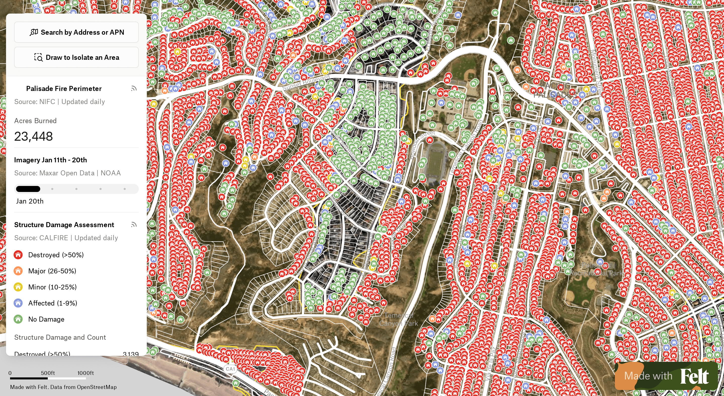
![[OC] Palisades Fire Open Data Map: Structural Damage and Recent Imagery](https://www.europesays.com/wp-content/uploads/2025/01/eraygxgt0mee1-1920x1024.png)
8 comments
This interactive map brings together a variety of open datasets to see the damage caused by the Pacific Palisades fire – you can search for an address, draw to isolate a specific area to return information, right click on the map to go directly to Google Street View and more.
[https://felt.com/map/Palisades-Fire-damage-64ZIfoYQT8a31wsk5Gpw6B?loc=34.05063%2C-118.54114%2C15.01z&utm_source=reddit&utm_medium=social](https://felt.com/map/Palisades-Fire-damage-64ZIfoYQT8a31wsk5Gpw6B?loc=34.05063%2C-118.54114%2C15.01z&utm_source=reddit&utm_medium=social)
**Were you or anyone you know impacted by these fires? Do you know of other open data sources that people can use?**
Map made with r/felt
Sources:
[California Fire Imagery from MAXAR and NOAA ](https://storms.ngs.noaa.gov/storms/2025_eri/index.html#9/34.105/-118.533)
[CAL FIRE DINS Database ](https://hub-calfire-forestry.hub.arcgis.com/apps/CALFIRE-Forestry::palisades-fire-structure-status/about?path=)[ ](https://data-nifc.opendata.arcgis.com/datasets/nifc::wfigs-current-interagency-fire-perimeters/about)
[Fire Perimeters](https://data-nifc.opendata.arcgis.com/datasets/nifc::wfigs-current-interagency-fire-perimeters/about)
[LA County Parcels ](https://data.lacounty.gov/documents/4d67b154ae614d219c58535659128e71/about)
It’s truly shocking to see that map then drop into Street View on a beautiful neighborhood knowing quite literally all of it is gone.
The size of this fire boggles my mind.
Wonder what is going on with some of the green dots in a sea of red? If these houses really were unscathed, then why is that?
Lets not forget that that although those houses marked green but surrounded by red have no structural damage (which is what this data is showing) but the contents of those properties would’ve surely been damaged by the smoke.
There aren’t any winners here
This looks like Cities Skylines notification icons from hell
if you right click on the map you can go to the specific location in Google Street View as u/chucchinchilla points out it is pretty shocking
https://preview.redd.it/wnwxsrdjemee1.png?width=1506&format=png&auto=webp&s=977a30151fbcd0a0f5893e4dda47a4831231a278
wow. thankful my friends in santa monica were spared, it’s clear here how close they were to devastation
Comments are closed.