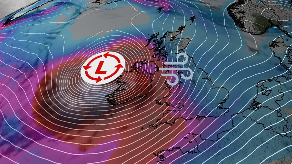
A powerful “bomb cyclone” named Storm Éowyn (pronounced AY-oh-win) will pummel parts of Ireland and the United Kingdom with fierce winds and heavy rainfall on Friday, and it has roots in the historic winter storm that just hit the U.S. Gulf Coast Tuesday.
Highest level of alerts issued in Ireland and parts of the United Kingdom: Red warnings for high winds have been hoisted in all of Ireland by the Irish Meteorological Service, Met Éireann.
The U.K. Met Office has also issued red warnings for high winds and heavy rain in Northern Ireland as well as central and southwest parts of Scotland. Other parts of Scotland and northern England are in the second-highest level alert.
The winds could knock out power, and cause tree and structural damage in some cases. Met Éireann says wind gusts in excess of 80 mph (130 km/h) are expected in parts of Ireland beginning Friday morning.
Peak wind gusts in the Northern Ireland and Scotland red warnings are forecast to be 80 to 90 mph, with up to 100 mph gusts possible on exposed western coasts, the U.K. Met Office said. This is the first red warning issued in Northern Ireland since the impacts-based warning system began in 2011.
Other parts of Scotland and northern England will also see strong winds gusting 60 to 70 mph, and possibly higher in some areas.
Shown below is the current winds analysis, but keep in mind the peak winds won’t arrive until Friday morning local time. The worst of the winds will wind down by later Friday and Friday evening.
The “bomb cyclone” has its roots in the recent U.S. Gulf Coast winter storm. Jet stream energy that helped produce historic snowfall on the U.S. Gulf Coast Tuesday triggered the development of low pressure off the southeastern U.S. coast. From there, that low has rapidly intensified over the North Atlantic and will reach Ireland and the U.K. as an intense “bomb cyclone” by Friday.
This means the storm’s low pressure has dropped by at least 24 millibars in 24 hours or less, meaning it has rapidly intensified. Storm Éowyn will likely more than double the criteria.
The reason this all matters beyond just a geeky statistic is the lower the pressure in a storm, the more intense it is. And the greater the difference in pressure over an area, the stronger the winds.
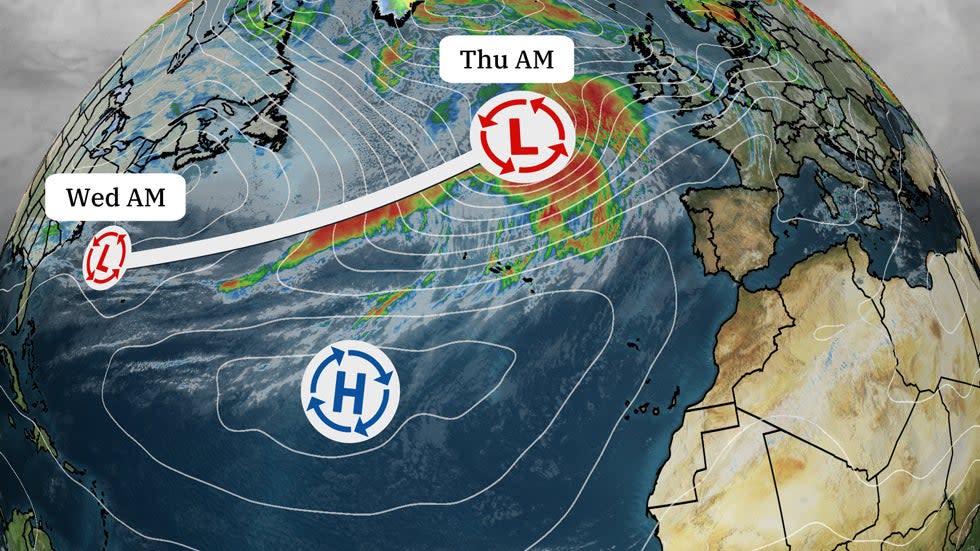
The low-pressure system formed Wednesday morning off the Southeast coast. It has rapidly-intensified along it trek through the North Atlantic.
Chris Dolce has been a senior meteorologist with weather.com for over 10 years after beginning his career with The Weather Channel in the early 2000s.