Protective barriers surrounding the Svartsengi area in early November 2024. (Photo: The Icelandic Met Office / Bjarki Kaldalóns Friis)
Hazard assessment has
been updated. Adverse weather in the coming days may affect the sensitivity of
the monitoring network.
Updated 28. January at 17:30 UTC
Ground uplift and magma accumulation under Svartsengi continues
The volume
of magma accumulating beneath Svartsengi is approaching the volume drop that occurred
during the last event
The likelihood of a new magma intrusion and potentially an eruption is
increasing
There is a possibility that seismic activity may not be significant
prior to the next eruption
The updated hazard assessment is valid until February 11, barring
further developments
Deformation
measurements indicate continued ground uplift and magma accumulation beneath
Svartsengi. The sequence of events remains similar to those observed before the
last eruptions. Modeling calculations show that the volume of magma
accumulating beneath Svartsengi is nearing the volume drop that occurred during the last event.
Based on
the analysis of previous events, scientists have assessed that once a similar
volume of magma has accumulated beneath Svartsengi as during previous
eruptions, the likelihood of a new magma intrusion and even an eruption
increases.
New hazard assessment
reflects increased eruption likelihood
The Icelandic
Meteorological Office has updated the hazard assessment, which is now valid
until February 11, barring any changes. It has been decided to raise the hazard
level in zones 4 and 6 from “moderate” (yellow) to “considerable” (orange).
This change is based on modeling calculations indicating that the volume of
magma accumulating beneath Svartsengi is nearing the volume drop that occurred during the last event.
According
to the weather forecast, severe weather is expected to occur in the coming days, beginning January 30.throughout the week.
A southern storm accompanied by significant warming, rain, and drizzle is forecasted
for southern and western parts of the country later this week and into the
weekend. Adverse weather could reduce the sensitivity of the monitoring
network, potentially delaying response times to an eruption.

(Image of the updated hazard map)
Little seismic
activity could precede the next eruption
Seismic activity in the Sundhnúkar crater row
has been increasing gradually since the end of the eruption on December 9,
2024, but overall it remains low. Developments over the past year suggest that
seismic activity prior to magma intrusions has been decreasing with each event.
Consequently, there is a possibility that seismic activity may not be
significant prior to the next eruption.
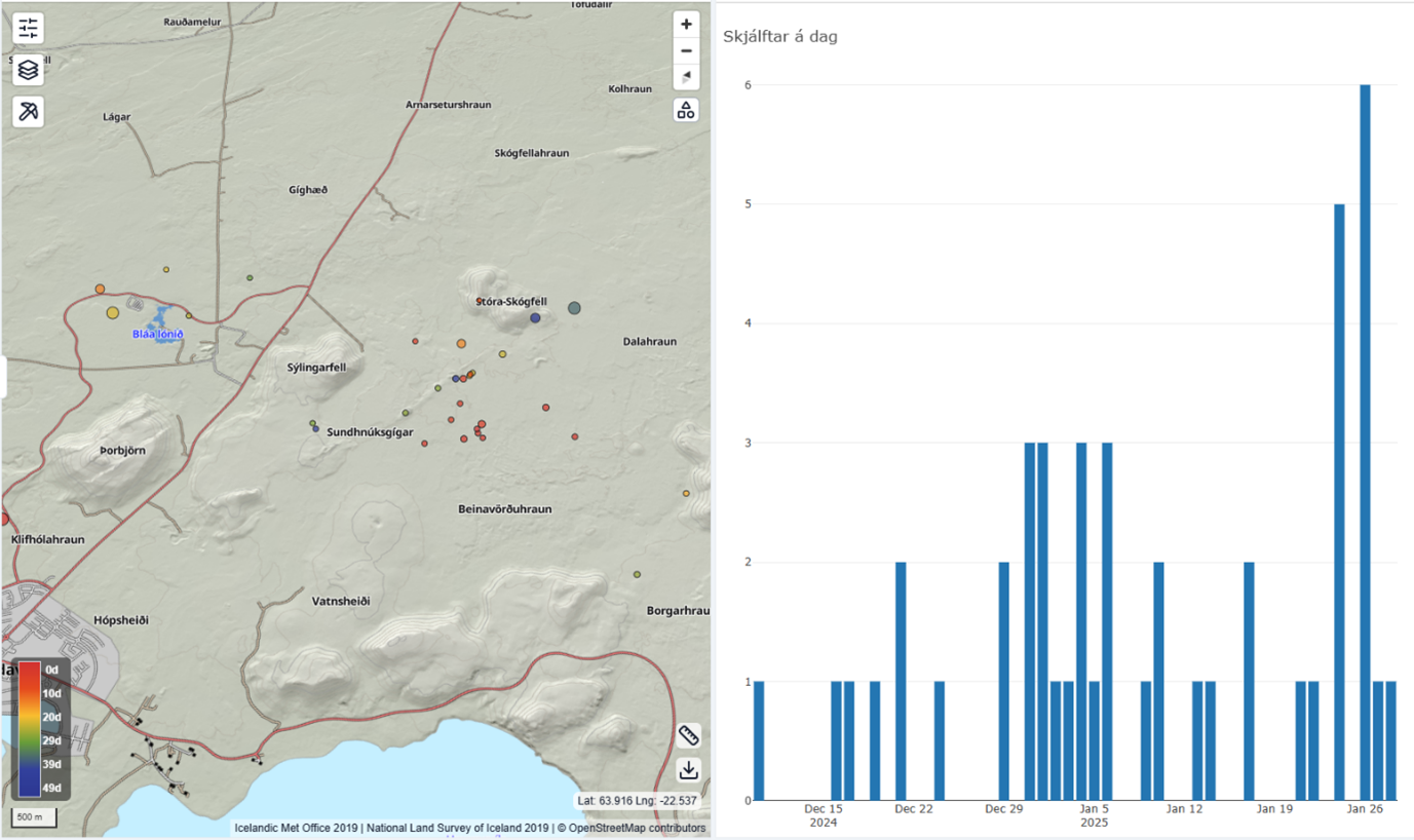
Seismic activity near the Sundhnúkar Crater
Row, displaying the number of earthquakes per day since December 2024.
Updated 14. January at 15:05
Seismic activity remains relatively low
Latest data suggests that the likelihood of magma intrusion and potentially
an eruption will increase end of January
Updated hazard assessment valid until January 28,
2025, unless conditions change
Land uplift in the Svartsengi area continues at a similar rate to previous
weeks. By the end of January or beginning of February, the likelihood of an
eruption starts to increase, as model calculations indicate that approximately
12 million cubic meters of magma will have accumulated beneath Svartsengi by
that time. The models are based on estimated magma inflow rates, but minor
changes in inflow could impact the estimated timing of the next eruption.
Seismic activity around Svartsengi remains low,
similar to recent weeks.
The Icelandic Meteorological Office hazard
assessment has been updated with no changes made. It remains valid, barring any
changes, until January 28.
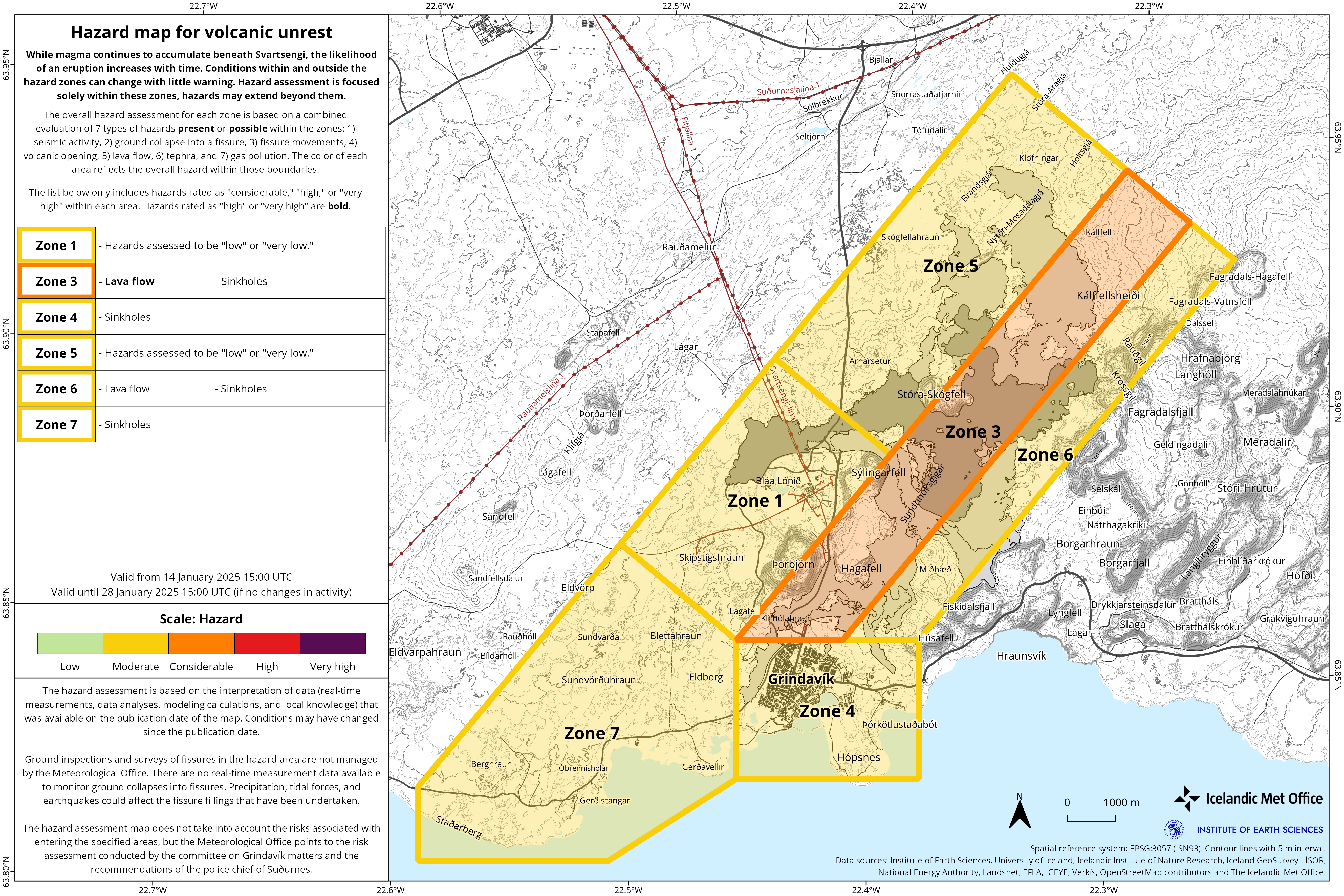
(Click on the map to make larger)
Latest
data suggests that the likelihood of
magma intrusion and potentially an eruption will increase as of January.Geodetic model results estimate magma inflow rates similar to the rate leading up to the last eruption.Updated
hazard assessment valid until January 14, 2025, unless conditions change.
Deformation data up to December 30, 2024, indicates
that magma accumulation beneath Svartsengi continues.
The likelihood of a new magma intrusion and
potentially an eruption is expected to increase when the volume of magma
beneath Svartsengi matches the amount that left the magma region during the
magma intrusion and eruption on November 20. Geodetic model results estimate
this volume to be between 12 and 15 million cubic meters.
According to
the latest deformation data, the magma inflow rate is currently estimated at
just over 3 m³/s, similar to the rate observed before the last eruption. If magma accumulation continues at the current rate, the magma
volume beneath Svartsengi is projected to reach 12 million m³ by late January
and approximately 13.5 million m³ by the first week of February. Therefore, the likelihood of magma intrusion
and potentially an eruption along the Sundhnúkur crater row may increase as of
late January.
These estimates are based on calculated magma inflow
rates over time, and small changes in these rates can affect projections for
the timing of a potential eruption.
Lava Field Remains Hazardous to Hikers
The
Icelandic Meteorological Office’s hazard assessment has been updated and
remains valid, barring any changes, until January 14, 2025.
The main change concerns Zone 6, where the overall
hazard level has been revised from significant (orange) to moderate (yellow).
The overall hazard in Zone 6 is now considered lower due to a reduced lava flow
hazard. However, while the danger due to the lava flow is currently deemed
lower, the existing lava field remains hot and dangerous to cross.

Earthquake Swarms Near Eldey Common in
Recent Years
Seismic activity has been minimal along the Sundhnúkur
crater row since the last eruption ended on December 8, 2024.
However,
some seismic activity has been recorded in other nearby areas. Approximately
200 earthquakes, including two over magnitude 3, were detected during a swarm
from December 29–31, 2024, near Eldey on the Reykjanes Ridge. Earthquake swarms
near Eldey have been frequent in recent years, with nearly 60 earthquakes over
magnitude 3 recorded there in the past four years.
While occasional earthquakes are still being detected,
the swarm has mostly subsided. Regular small earthquakes continue to occur in
the western part of Fagradalsfjall, where over 60 minor earthquakes have been
recorded in the past month, most at depths of 6–8 km.