I’m surprised a county along the Ohio river in Ohio is darker than Columbus with OSU… probably because despite there being so many students, the “civilian” population is just so much higher.
Disclaimer: I am trying to map which places are the most college town-y, so I removed all online-only universities and for 3 universities with high online enrollment (SNHU, BYUI, Liberty) I looked up their on-campus enrollment and used that. I assume that all students live within the same county-equivalent as their school, and this is probably a reasonable assumption except for in Virginia’s independent cities.
edit: I just realized that Purdue Global and UMD Global aren’t marked as online-only in the data for whatever reason. I apologize for the oversight. Tippecanoe County, IN shouldn’t be in the top 10. It should be about 22%.
I didn’t realize Central Washington University was such a presence.
Okay. You’ve found the college towns. Is that what you were trying to do?
Or, were you looking for what area was sending the most kids to college? That’s a totally different stat.
Virginia kind of messes this up when many of the cities are completely separate from the counties that surround them.
These college towns have a massive effect on the state. Look at Tippecanoe County, Indiana, home of Purdue. From a political standpoint, it’s much more left-leaning than most of the state (same as Monroe County in southern Indiana.)
Hmm, I suspect this is more like:
>where colleges and universities are located
Universities in Top 10 Counties (respective order)
1. Williamsburg, VA: **William and Mary University**
2. Whitman County, WA: **Washington State University**
3. Clay County, SD: **University of South Dakota**
4. Tippecanoe County, IN: **Purdue University**, **Indiana Tech**
5. Lexington, VA: **VMI**, **Washington and Lee University**
6. Lumpkin County, GA: **University of North Georgia**
7. Whitley County, KY: **University of the Cumberlands**
8. Radford, VA: **Radford University** (duh)
9. Sumter County, AL: **University of West Alabama** (shoutout to Malcolm Butler)
10. Madison County, ID: **Brigham Young University-Idaho**
It’s interesting to see that the highest percentages are in rural areas, implying that instead of there being a ton of schools in each county there are just no locals XD
It’s funny seeing West Alabama and Troy dominate their counties when those are pretty small schools; just in even smaller counties; while the much larger Auburn, Alabama, and UAB barely make a mark.
So… this is basically a population map?
Interesting map.
1. Col. of William and Mary, student pop 9517
2. Washington State U., student pop 20976 (undated) at Pullman Campus
3. U. of South Dakota, student pop 9971
4. Purdue U., student pop 5211
5. Virginia Military Inst., student pop 1560; Washington and Lee U., student pop 2223
6. U. Of North Georgia, student pop 19722
7. U. Of Cumberlands, student pop 20347 but only 6100 are undergrad. Online postgraduate maybe?
8. Radford U., student pop 10700
9. U. Of West Alabama, student pop 5157
10. Confusing , Wikipedia says the only school in Madison Cty ID is a community college. **NVM someone else pointed out BYU had a campus in Madison Cty (student pop 45584); the Wikipedia page didn’t mention**
That exponential color scale does not put much into perspective.
Not sure why there’s so much negative feedback. I thought the visual was quite clear, I learned something, and found it interesting while doing so.
I see my college there, its very dark blue on the map. Makes sense as we’ve essentially got the university and wheat in the county
Why Does this scale go from 0-1, then 1-5, then 5-10, then 10-20, and then 20-63%???why such erratic spacing?
According to this chart, college towns have lots of college students.
Is there a reason the key is so inconsistent? I feel like having two shades for an only 5% difference is really unnecessary when the darkest shade covers more then 40%, is it something with how the data is collected? Definitely would be better to split that last category at least in half and combine the two lowest ones
Tippecanoe County Indiana is certainly not 52% students. The county has 185,000 residents and Purdue only has about 40,000 students.
William and Mary,
Loved of old,
Hark upon the gale.
Hear the thunder
Of our chorus.
Alma mater, hail.
Wyoming has ONE school with athletics
Guess where it is…
Voters in Tippercanoe, IN (Purdue), Riley, KS (Kansas State), and Centre, PA (Penn State) who aren’t students must be redder than the a tomato to keep the counties close.
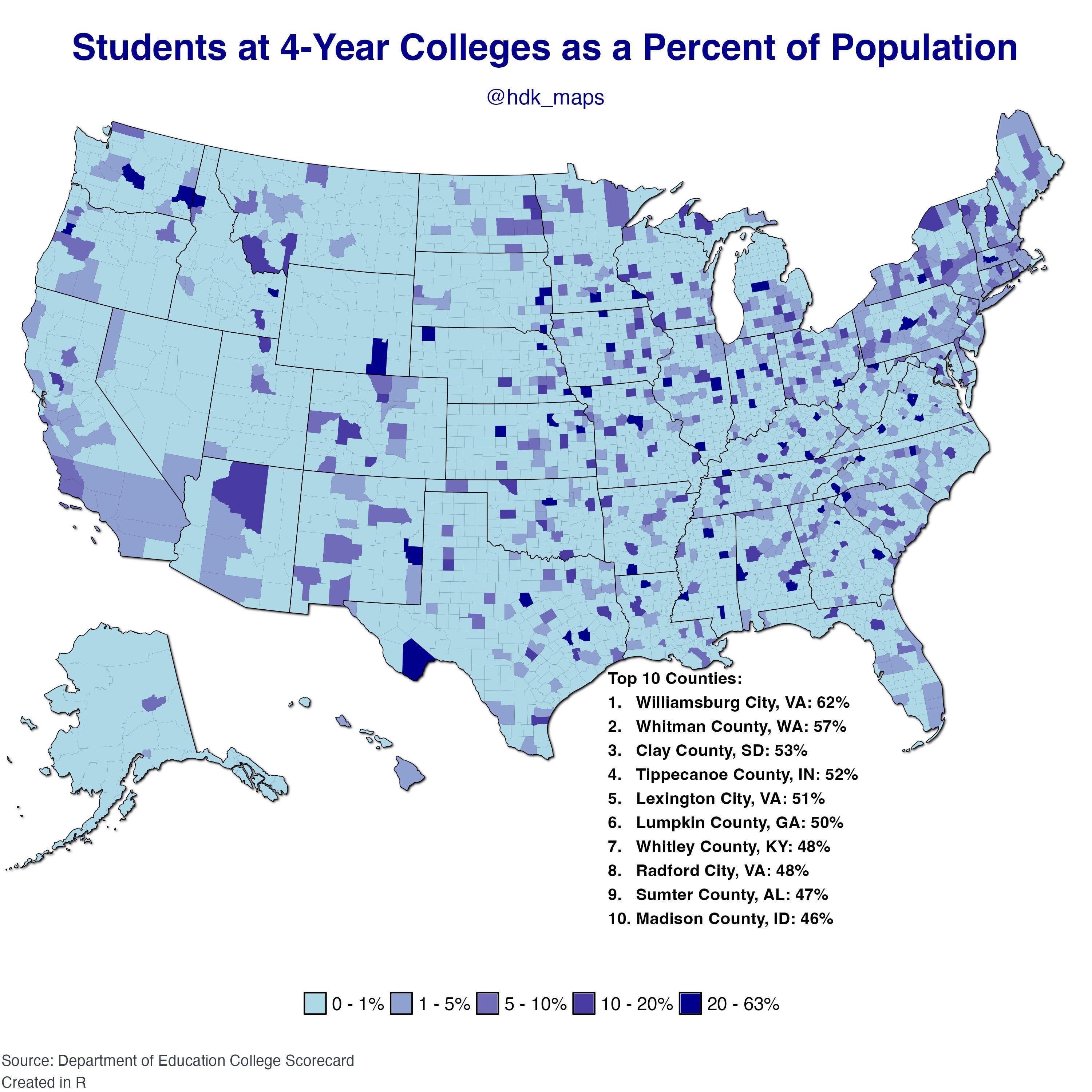
![[OC] Students at 4-Year Colleges as a Percent of the Population](https://www.europesays.com/wp-content/uploads/2025/02/xfh0kko75qie1-1920x1024.jpeg)
25 comments
I’m surprised a county along the Ohio river in Ohio is darker than Columbus with OSU… probably because despite there being so many students, the “civilian” population is just so much higher.
Data: [https://collegescorecard.ed.gov/data/](https://collegescorecard.ed.gov/data/)
Tools: R – packages: ggplot2, dplyr, stringr, sf, usmap, ggfx, scales
Disclaimer: I am trying to map which places are the most college town-y, so I removed all online-only universities and for 3 universities with high online enrollment (SNHU, BYUI, Liberty) I looked up their on-campus enrollment and used that. I assume that all students live within the same county-equivalent as their school, and this is probably a reasonable assumption except for in Virginia’s independent cities.
edit: I just realized that Purdue Global and UMD Global aren’t marked as online-only in the data for whatever reason. I apologize for the oversight. Tippecanoe County, IN shouldn’t be in the top 10. It should be about 22%.
I didn’t realize Central Washington University was such a presence.
Okay. You’ve found the college towns. Is that what you were trying to do?
Or, were you looking for what area was sending the most kids to college? That’s a totally different stat.
Virginia kind of messes this up when many of the cities are completely separate from the counties that surround them.
These college towns have a massive effect on the state. Look at Tippecanoe County, Indiana, home of Purdue. From a political standpoint, it’s much more left-leaning than most of the state (same as Monroe County in southern Indiana.)
Hmm, I suspect this is more like:
>where colleges and universities are located
Universities in Top 10 Counties (respective order)
1. Williamsburg, VA: **William and Mary University**
2. Whitman County, WA: **Washington State University**
3. Clay County, SD: **University of South Dakota**
4. Tippecanoe County, IN: **Purdue University**, **Indiana Tech**
5. Lexington, VA: **VMI**, **Washington and Lee University**
6. Lumpkin County, GA: **University of North Georgia**
7. Whitley County, KY: **University of the Cumberlands**
8. Radford, VA: **Radford University** (duh)
9. Sumter County, AL: **University of West Alabama** (shoutout to Malcolm Butler)
10. Madison County, ID: **Brigham Young University-Idaho**
It’s interesting to see that the highest percentages are in rural areas, implying that instead of there being a ton of schools in each county there are just no locals XD
It’s funny seeing West Alabama and Troy dominate their counties when those are pretty small schools; just in even smaller counties; while the much larger Auburn, Alabama, and UAB barely make a mark.
So… this is basically a population map?
Interesting map.
1. Col. of William and Mary, student pop 9517
2. Washington State U., student pop 20976 (undated) at Pullman Campus
3. U. of South Dakota, student pop 9971
4. Purdue U., student pop 5211
5. Virginia Military Inst., student pop 1560; Washington and Lee U., student pop 2223
6. U. Of North Georgia, student pop 19722
7. U. Of Cumberlands, student pop 20347 but only 6100 are undergrad. Online postgraduate maybe?
8. Radford U., student pop 10700
9. U. Of West Alabama, student pop 5157
10. Confusing , Wikipedia says the only school in Madison Cty ID is a community college. **NVM someone else pointed out BYU had a campus in Madison Cty (student pop 45584); the Wikipedia page didn’t mention**
That exponential color scale does not put much into perspective.
Not sure why there’s so much negative feedback. I thought the visual was quite clear, I learned something, and found it interesting while doing so.
I see my college there, its very dark blue on the map. Makes sense as we’ve essentially got the university and wheat in the county
Why Does this scale go from 0-1, then 1-5, then 5-10, then 10-20, and then 20-63%???why such erratic spacing?
According to this chart, college towns have lots of college students.
Is there a reason the key is so inconsistent? I feel like having two shades for an only 5% difference is really unnecessary when the darkest shade covers more then 40%, is it something with how the data is collected? Definitely would be better to split that last category at least in half and combine the two lowest ones
Tippecanoe County Indiana is certainly not 52% students. The county has 185,000 residents and Purdue only has about 40,000 students.
William and Mary,
Loved of old,
Hark upon the gale.
Hear the thunder
Of our chorus.
Alma mater, hail.
Wyoming has ONE school with athletics
Guess where it is…
Voters in Tippercanoe, IN (Purdue), Riley, KS (Kansas State), and Centre, PA (Penn State) who aren’t students must be redder than the a tomato to keep the counties close.
This looks like an election map 🤔
Interesting visual. Does this just become a map of colleges across the USA? ex: [https://banner2.cleanpng.com/20180602/wrw/kisspng-ncaa-men-s-division-i-basketball-tournament-colleg-5b1253aa102957.2163140215279277220662.jpg](https://banner2.cleanpng.com/20180602/wrw/kisspng-ncaa-men-s-division-i-basketball-tournament-colleg-5b1253aa102957.2163140215279277220662.jpg)
A similar visualization but looking at percentage of young adults in college.
[https://www.reddit.com/r/dataisbeautiful/comments/1bk6c42/what_us_counties_have_the_highest_percentage_of/](https://www.reddit.com/r/dataisbeautiful/comments/1bk6c42/what_us_counties_have_the_highest_percentage_of/)
Comments are closed.