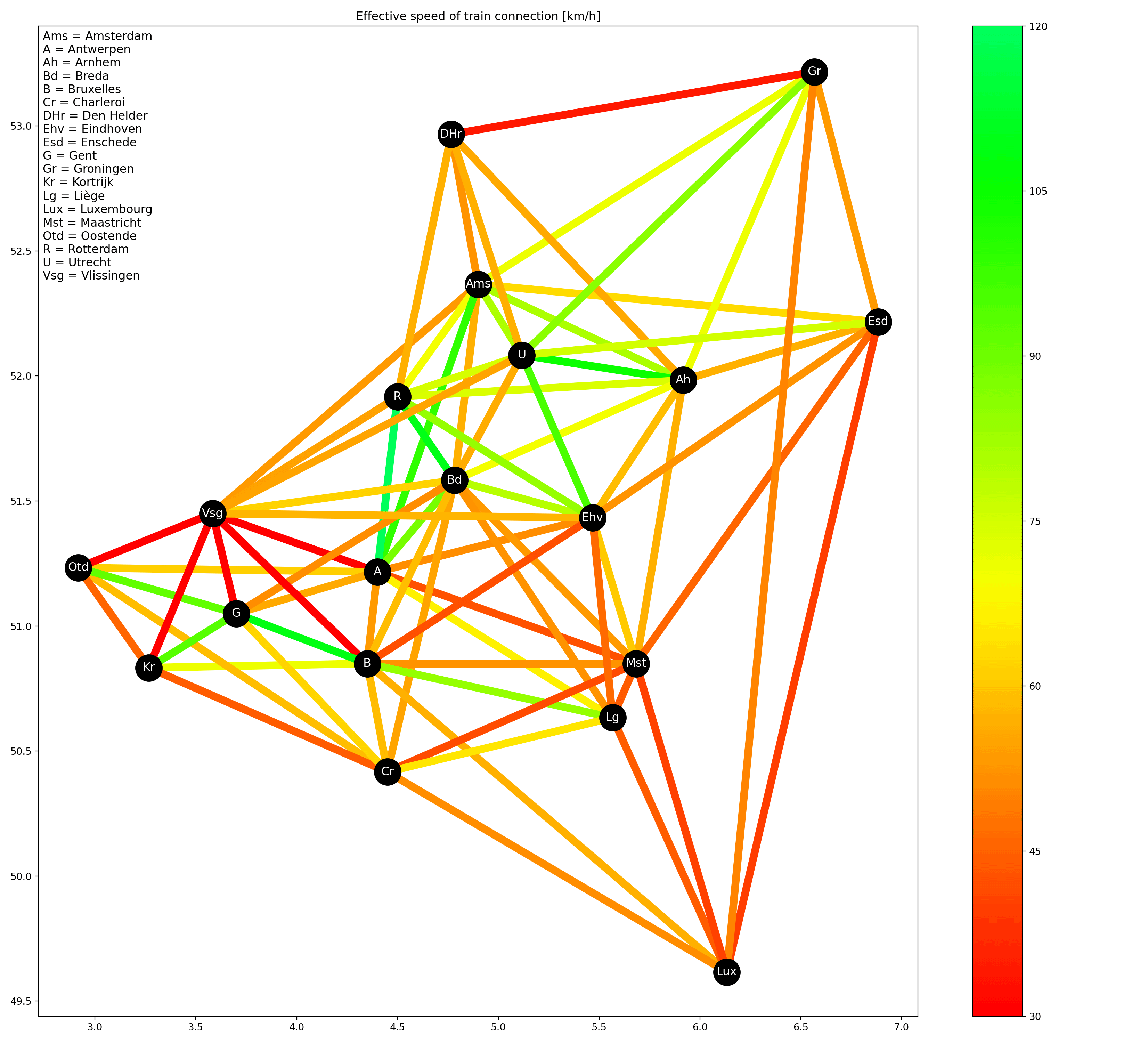
[OC] How fast is the train? Effective speed (as-the-crow-flies distance divided by travel time of fastest connection) of train connections between 19 cities in the Benelux
Posted by midnightrambulador
![[OC] How fast is the train? Effective speed (as-the-crow-flies distance divided by travel time of fastest connection) of train connections between 19 cities in the Benelux](https://www.europesays.com/wp-content/uploads/2025/02/f5ygmjzi1dje1-1920x1024.png)
[OC] How fast is the train? Effective speed (as-the-crow-flies distance divided by travel time of fastest connection) of train connections between 19 cities in the Benelux
Posted by midnightrambulador
4 comments
Sources:
* Coordinates: Wikipedia
* Distances: [haversine formula](https://www.movable-type.co.uk/scripts/latlong.html)
* Travel time (NL-NL): https://www.ns.nl/
* Travel time (BE-BE): https://www.belgiantrain.be/
* Travel time (NL-BE & BE-LU): https://www.b-europe.com/
* Travel time (NL-LU): https://www.nsinternational.com/
All travel times were requested manually from the various route planners (probably I could have done something fancy with API calls but figuring that out would have taken a lot longer). All requests were made today (February 15th, 2025). Reference date was Tuesday morning March 4th. I took the fastest connection I could find without clicking “earlier/later”.
For the plot I manually pruned away a lot of lines which were on top of each other and/or cut through 3rd cities. I do have the speed values for every combination of cities, these are [here](https://i.imgur.com/PIY9hzC.png).
Plot was made with Python (pandas and matplotlib).
Very cool vis! Somehow the journey from Utrecht to Eindhoven feels super slow but apparently I’m wrong.
What’s your source / methodology?
That’s a really cool visualization. It’s kinda obvious that Den Helder – Groningen is dark red, as there’s no direct connection over the Afsuitdijk and the train goes via Amsterdam and Utrecht (or Almere)
Sometimes the fastest route is more than twice as long as the shortest route. Looking at Vlissingen, and Kortrijk – Charleroi (it *is* faster via Brussels than via Tournai/Mons ; I think because “all rails lead to Brussels”).
Comments are closed.