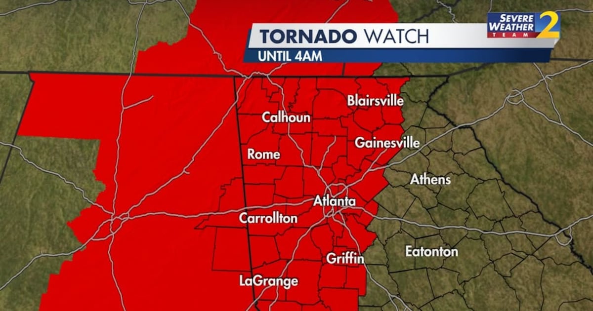
ATLANTA — A Tornado Watch is in effect for most of the metro Atlanta and north Georgia areas until 4 a.m.
Severe Weather Team 2 is tracking severe storms that are expected to move across north Georgia overnight Saturday and into early Sunday morning.
[DOWNLOAD: Free Severe Weather Team 2 App for alerts wherever you go]
Live updates for our storm coverage continue here:
12:09 a.m.: Flash Flood Warning for Bartow, Carroll, Cobb, Douglas, Floyd, Haralson, Paulding and Polk counties until 6:00am Sunday.
11:58 p.m.: Severe Thunderstorm Warning for Bartow, Carroll, Douglas, Floyd, Haralson, Paulding and Polk counties until 12:30 a.m.
11:50 p.m.: Tornado Warning issued for Cherokee, Cobb, and Paulding counties until 12:15 a.m.
11:00 p.m.: Severe Thunderstorm Warning issued for Bartow, Carroll, Cobb, Coweta, Douglas, Floyd, Fulton, Gordon, Haralson, Heard, Paulding and Polk counties until 12 a.m.
9:40 p.m.: Fannin County Emergency Management is reporting a possible tornado near Chestnut Gap Rd.
9 p.m.: Much of the area is under a tornado watch now until 4 a.m. (and 1 a.m. in far NW GA). We were just with you on Channel 2 Action News for the first two tornado warnings of the day — those storms have moved out of our viewing area.
MORE SEVERE WEATHER PREPS:
Storms are expected to move into far northwest Georgia around 8 p.m. and make their way to metro Atlanta between 1 a.m. and 3 a.m.
Severe Weather Team 2 Chief Meteorologist Brad Nitz says that multiple strong tornadoes are possible in the early morning hours of Sunday.
During thunderstorms, damaging wind gusts could reach 70 mph or greater, and large hail with a one to two-inch diameter is possible.
The storms are expected to move out of the area by daybreak.
Much of north Georgia is now under a Wind Advisory that goes until 5 a.m. on Sunday.
Wind gusts up to 40 miles per hour are possible on Saturday afternoon, with higher gusts possible at higher elevations.
This could mean some trees and power lines could start coming down even before the strongest storms move into the area overnight.
If a tornado warning is issued in your area, here are some things to keep in mind:
Take cover: Go to the lowest level of your house and into an interior room, away from windows.Mobile homes and automobiles are not safe, find a shelter.Do not try to outrun a tornado if you are on the road.
Severe Weather Team 2 will be tracking these storms, LIVE throughout the day on Channel 2 Action News.
[INTERACTIVE: StormTracker 2HD Radar]
©2025 Cox Media Group