
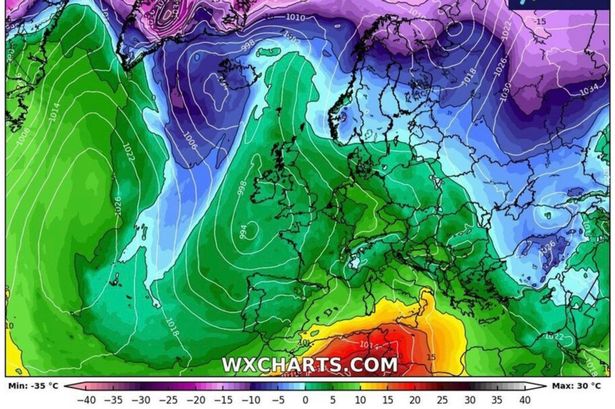
 Much of South England and the Midlands will enjoy conditions between 13C-16C(Image: WXCHARTS)
Brits are set to face balmy weather in just days with temperatures set to shoot to 16C, according to new weather maps.
The end of the colder weather conditions appear to be in sight. From March 19 and lasting until March 21, temperatures up and down Britain are expected to rise by roughly 10C from what they are now in some areas.
Much of South England and the Midlands will enjoy conditions between 13C-16C, with the warmest areas being London and Surrey, according to weather maps by Net Weather and WXCharts.
It’s higher than the average temperature for March – which is highs of 11C and lows of 8C.
 The warm weather is in sight (stock)(Image: Getty Images)
By 3pm on Wednesday, other areas in North England will also be warmer, with temperatures averaging between 12C and 13C, compared with 8C on Saturday.
Even the Scottish Highlands will join in on the fun, though not to the same extent as the rest of the UK.
Temperatures this far north may only just creep to double digits, but this is still an improvement on the March average of between 1C and 8C.
 Time to get the sunglasses out (stock)(Image: Getty Images)
The Met Office long range forecast for March 19-28 reads: “High pressure is expected to be centred to the east of the UK initially, with a good deal of fine, dry and reasonably sunny weather in a south to southeasterly flow.
“Temperatures are expected to rise, to well above average in some areas.
“Later in the week there will likely be a gradual transition to less settled conditions from west to east, as low pressure becomes more dominant with an increasing chance of rain or showers by the weekend and into the final week of March, perhaps heavy in places.
“Temperatures, initially above average, will likely trend back closer to normal, although with more cloud this will tend to reduce the risk of frost to an extent