Athens, April 16, 2025 – A new chapter in Greece-Türkiye relations unfolded as both nations issued statements regarding their respective Maritime Spatial Planning (MSP) initiatives, highlighting competing claims in the Aegean Sea and Eastern Mediterranean. The developments underscore ongoing tensions over maritime boundaries, with Greece emphasizing its compliance with international law and Türkiye asserting its maritime jurisdiction.
Greece: A Step Toward Expanding Diplomatic Influence
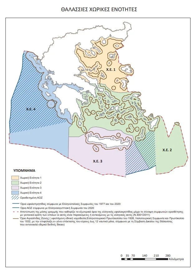
In an interview with Skai TV on Wednesday, Greek Foreign Minister George Gerapetritis hailed the establishment of Greece’s National Spatial Strategy for Maritime Space (NSSMS) as a historic milestone. “Greece grows taller and expands its diplomatic imprint,” Gerapetritis declared, noting that the NSSMS, published on April 16, 2025, marks the first time Greece has officially recorded the extreme limits of its continental shelf.
The NSSMS, spearheaded by the Ministry of Environment and Energy in collaboration with the Foreign Affairs Ministry, maps Greece’s Maritime Spatial Planning in accordance with European Commission Directive 2014/89/EC, which mandated Greece to issue its maritime maps by April 27, 2025. Gerapetritis emphasized that Greece’s actions are grounded in international law, particularly the United Nations Convention on the Law of the Sea (UNCLOS).
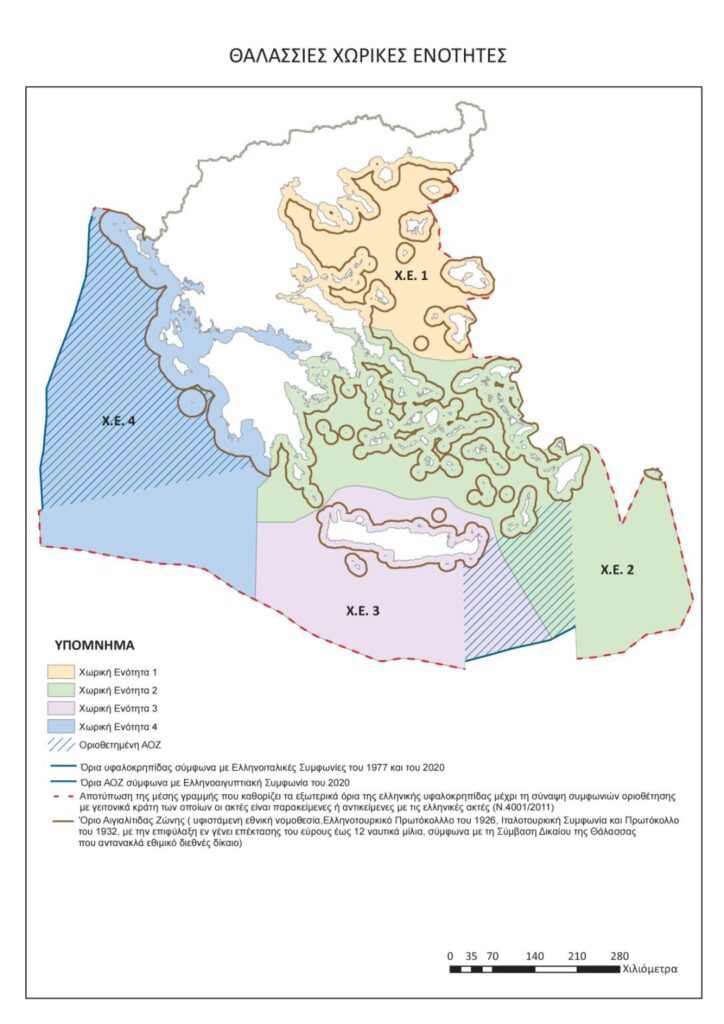
“This is a very important day for Greece,” the minister said, highlighting that the NSSMS delineates the furthest potential limits of Greece’s maritime zones. Addressing Türkiye’s parallel maritime mapping efforts, Gerapetritis suggested that differing claims could be resolved through dialogue and mutual understanding to define exclusive economic zones (EEZs). He reiterated Greece’s commitment to diplomacy, noting the European Court’s role in obliging Greece to formalize its maritime boundaries.
Türkiye: A Firm Rejection of Greece’s Claims
Türkiye’s Ministry of Foreign Affairs swiftly responded to Greece’s announcement, condemning the NSSMS for infringing on Türkiye’s maritime jurisdiction in the Aegean Sea and Eastern Mediterranean. In a statement issued on April 16, 2025, the ministry declared that “some of the areas specified in Greece’s Maritime Spatial Planning violate the maritime jurisdiction areas of our country.”
The Turkish Foreign Ministry dismissed Greece’s unilateral actions as having “no legal consequences” for Türkiye, emphasizing that Ankara remains open to cooperation with Athens. The statement underscored Türkiye’s commitment to resolving disputes through a “sincere and comprehensive approach” based on international law, equity, and good neighborliness, as outlined in the Athens Declaration on Friendly Relations and Good Neighborliness signed on December 7, 2023.
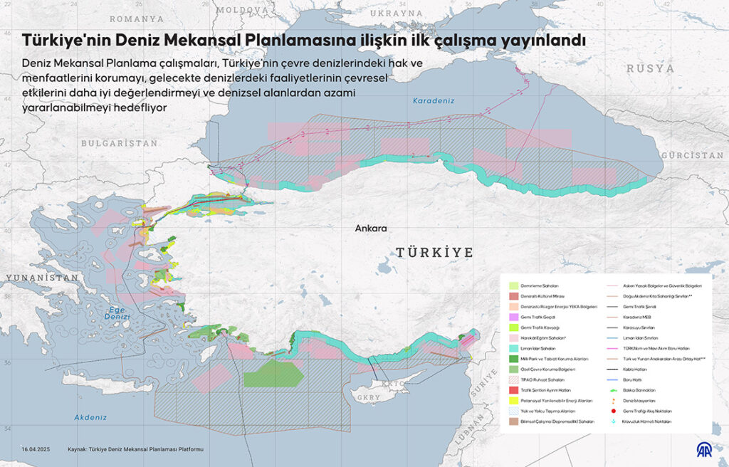
Türkiye also announced that its own Maritime Spatial Planning is being forwarded to UNESCO and relevant United Nations bodies, signaling a parallel effort to assert its maritime claims on the international stage.
A Broader Context of Maritime Disputes
The competing maritime claims reflect longstanding tensions between Greece and Türkiye over territorial waters, continental shelves, and exclusive economic zones in the Aegean and Eastern Mediterranean. Greece, a signatory to UNCLOS, bases its claims on the treaty’s provisions, while Türkiye, which is not a party to UNCLOS, argues that the unique geography of the Aegean Sea necessitates equitable solutions beyond standard international frameworks.
The timing of both announcements is significant, as Greece’s NSSMS aligns with EU obligations, while Türkiye’s response underscores its determination to protect its perceived rights in the region. Gerapetritis’ call for dialogue and Türkiye’s invocation of the Athens Declaration suggest potential avenues for de-escalation, but the overlapping claims could complicate bilateral relations.
Looking Ahead
As Greece and Türkiye submit their respective maritime plans to international bodies, the international community will closely monitor how both nations navigate this dispute. The path forward may involve diplomatic negotiations, potentially facilitated by frameworks like the Athens Declaration or international mediation. For now, the dueling maritime maps highlight the challenges of balancing national interests with regional stability in a geopolitically sensitive region.
Source: ANA-MPA, Turkish Ministry of Foreign Affairs Statement