
Got this beautiful gigantic aerial photograph of Newport at a car boot a few years ago and was trying to figure out when it was taken, any ideas?
by MysteriousRange8732
Got this beautiful gigantic aerial photograph of Newport at a car boot a few years ago and was trying to figure out when it was taken, any ideas?
by MysteriousRange8732
11 comments
Bro, tf happened to Newport
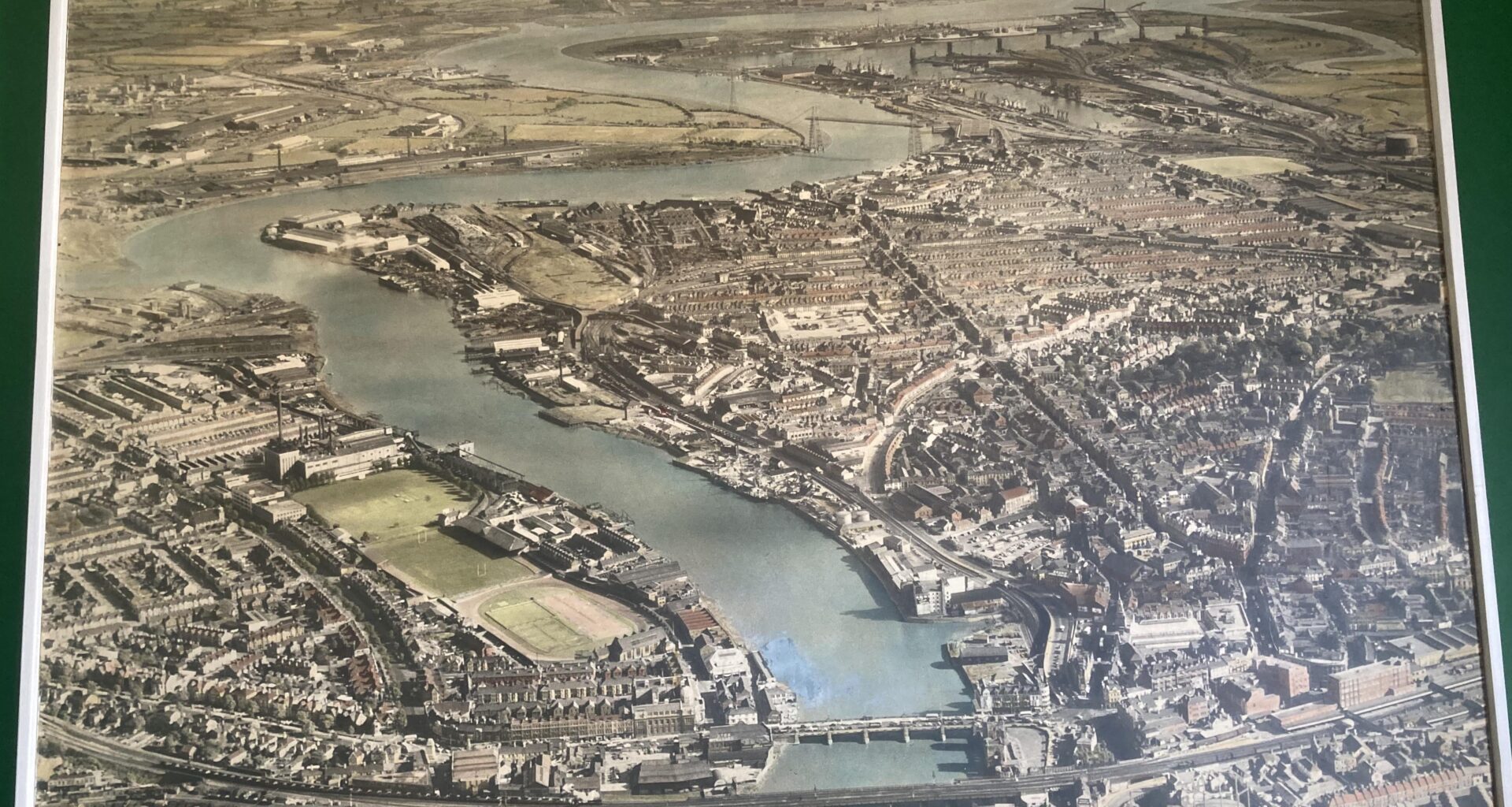
The footbridge to Rodney Parade isn’t there, so it’s pre-2006.
The Southern Distributor Road is also missing, so it’s pre-2004.
during the day i’m guessing
Back when dragons still used to do the flyovers, of course!
I’d say the 1930s. I’ve seen a picture of Ponty, similar to this, which was taken then.
1950’s maybe…
Yeah no George St Bridge which was 1962. The photograph style suggests a pre war era. I cannot see the memorial gates at Rodney Parade which I think were built between 1922-1933 so perhaps some time before 1933. I don’t know the docks well but I think the South Dock Extension is there which makes it at least 1914.
Try playing with [this](https://maps.nls.uk/geo/explore/side-by-side/#zoom=16.5&lat=51.59005&lon=-2.99387&layers=261&right=ESRIWorld). It’s from the national library of Scotland, you can overlay current satellite images with old maps or view side by side. It’s my favourite thing to waste time with
Does anyone remember people going door to door trying to sell you already printed photos of your house? I bought one once after knocking the guy down to half price. The next time somebody tried, I already had a photo as a bargaining tool to get that one even cheaper.
My parents had one which featured my dad in the garden wearing light brown shorts, but he looked to be naked.
Great pic. The original Usk mouth power station can be seen. That was opened in the 1950s. In top right you can see the meandering river Ebbw, which is now Docksway landfill. What kind of psychopath decided to divert the river into a concrete channel and fill the old river with waste!?!?
I’m not suer how useful this is, but a couple of things we can take from the picture immediately:
1) The very first aerial photographs that historians know about were somewhere between 1880 -1900 (taken from a balloon). We know with 100% certainty this is after those dates. This is also roughly the same time that colour photography became possible for the masses
2) The transporter bridge opened in 1906. I’m not sure when construction started (or if it is in operation here), but this is a pretty solid earliest possible date.
3) It’s not completely clear in the photo, but it *looks* like Coronation Park exists with is playing field, which [was established in 1911](https://www.newportparks.org.uk/coronation/info/index.shtml).
4) It predates the [George Street Bridge](https://en.wikipedia.org/wiki/George_Street_Bridge,_Newport), which opened in 1962.
5) I can’t see the [entrance lodge](https://www.newportparks.org.uk/coronation/info/lodge.shtml) to Coronation Park, which was built in 1939/1940, but this may be too small to make out.
6) You can see what looks like the [Uskmouth Power Station](https://en.wikipedia.org/wiki/Uskmouth_power_stations), built in 1940 at the mouth of the river.
Sadly, I don’t know Newport well enough to comment on other specifics. I’d *guess* it was taken in the 1940-1960 era, but some of those things (e.g. the Power Station being built) are a bit fuzzy as I have no idea how long construction ran for before it opened, or what sat on the site beforehand.
Comments are closed.