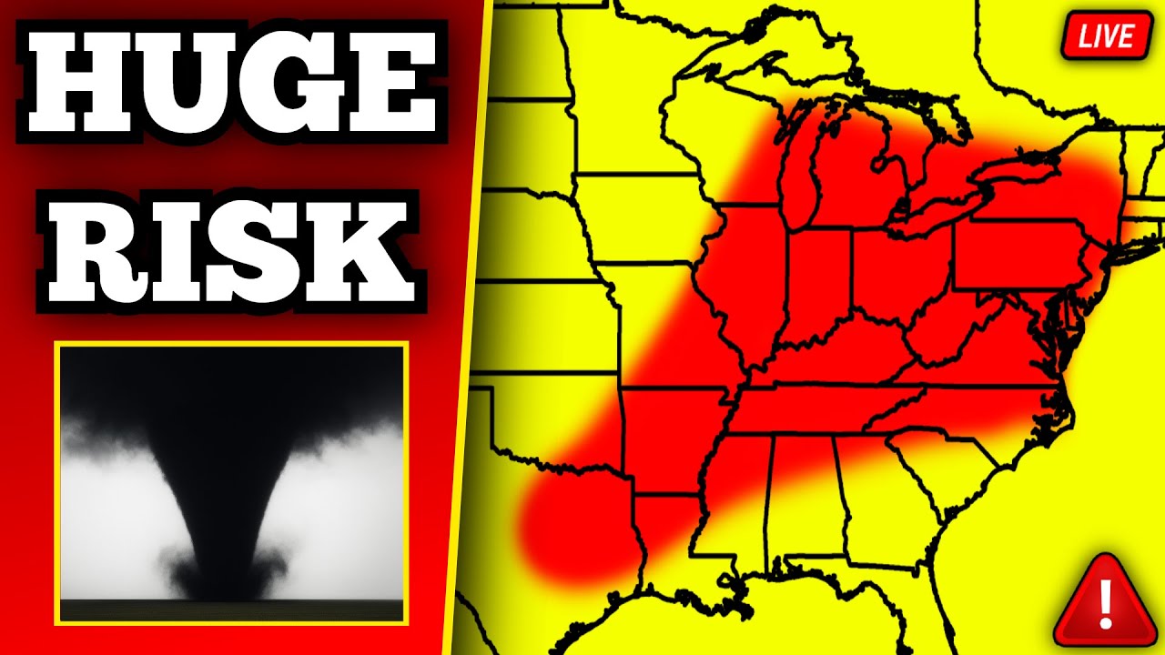
🔴 BREAKING Major Tornado Outbreak Coverage – Strong Tornadoes Likely With Live Storm Chasers
Alrighty, welcome back everybody to our latest severe weather coverage. Hope everybody’s having a good afternoon so far. Uh we are starting right off the bat with five tornado warnings and we have a large tornado in progress right now uh in Missouri. We already have a slew of tornado warnings that have already been issued across central and southern Missouri. And we have our first tornado of the day which is located just to the west of Summersville in Missouri. This is a huge tornado. We have a large debris signature right now on radar, crossing over Highway 137. Currently moving over Nagle and eventually going towards Midvail, Highway 17, and Summersville over the next few minutes. This is a likely strong tornado and it’s also a large tornado currently tracking to the east towards Highway 17 and it will be coming up on Highway 106 moving towards Eminence and as well as Highway 19 over the next few minutes. So, if you are in this tornado warning, uh you need to be in your storm shelter, basement, closet or bathroom. This is for Texas and Shannon counties in Missouri. Uh moving east at about 50 mph. This is our first of probably many significant tornadoes today. Uh that we are going to be seeing across both Missouri, Illinois, Kentucky, and several other states. Uh right now, this is definitely the most concerning storm that we have on radar though. Large debris signature again right now near Highway 137 currently tracking to the east. This has been on the ground for approximately 6 or 7 minutes. And the latest scan is showing a larger debris signature now right over the town of Naggle. and it’s going to be coming up on Midvail in the next few minutes. We have a storm also further down to the south that even looks more concerning right now near Mountain View coming up on Birch Tree. Uh we have stormchaser Jane Pepenheim bottom left of your screen who’s actually coming up on this right now. And this storm in my opinion is also very concerning. It is a very discreet supercell and there’s a large inflow coming into the storm and we could easily get a large tornado out of a storm like this as it continues to track along Highway 63 or I think that’s 63. Highway 60 over the next 15 to 20 minutes. So, this is another very concerning supercell that is currently tracking to the east that could produce a tornado at any moment. But once again, large tornado currently in progress right now over the town of Nagle. This is not a PDS tornado warning even though I believe this does meet the criteria for a PDS tornado warning. Uh this is a again large tornado currently heading into the town of Summersville. It will likely cause some very significant damage if it stays on the ground and will eventually be going towards Eminence in Missouri. So, you need to be in your storm shelter, basement, closet, or bathroom if you are in that tornado warning. Further to the north in Rola and St. James, we also have a tornado warning here. This is near I44. Uh, this is a fairly populated area right along the interstate that is currently in the path of a potential tornado. We actually have a camera that is in this warning. I’m going to put that on the bottom right. We’ll put Connor bottom middle. Uh, I’m going to go full cam to that really quickly. This is what it looks like inside of our tornado warning back up in Rola. So, this is in downtown Rola. I want to point out right off the bat that there’s actually some street flooding here. So, we’ve already had some flooding in this area, but in addition to that, there’s a potential for a tornado with this storm. Again, that’s what it looks like in downtown right now. We’ll be keeping a close eye on that camera. That’ll stay on the bottom right of your screen. Uh let’s actually go over to Jaden Pepenheim. He is currently near that southern he’s on the southern tornado warning. And so, this is what he’s looking at right now. Looks like a wall cloud right over the trees. Let me uh get his exact location here. Uh he’s currently located on that southern tornado warning near Mountain View. And you can actually see it looks like a wall cloud right beyond the tree line there. The velocities are pretty strong on radar right over Hutton Valley. And this may be about to drop a tornado coming up on Mountain View over the next few minutes. Wow. Um so the tornado warning off to the north. I’m going to keep Jaden bottom left. The tornado warning for Rola and St. James was just upgraded to 4in sized hail. You heard that right. 4in size tail that is the size of softballs is currently falling over the town of Rola coming up on St. James. If you are in this tornado warning, you’ve got to be in your safe place. This is a major storm. Not just producing a potential tornado threat, but is producing actively 4in sized hail. This is a destructive supercell and it might not produce a tornado, but it’s definitely going to be producing some very large hail. So, if you’re in St. James, you’ve got to be in your safe place. Could also be wind driven hail as well. Uh back over west of St. Louis, we also have storms firing up up here near Troy and Wensville. Most of these are hail and wind producers. Nothing tornatic as of yet, but we’ll be keeping a close eye on those. I also want to point out that there is a tornado warning in western Virginia. This is back over near Wise. Little QLCS tornado that is trying to form. Um, actually, let’s go to Jaden. That’s what Jaden’s looking at right now in that southern tornado warning in Missouri. That’s a drone shot. I don’t think he has audio on, but Jane does have a view there it looks like, of the uh at least the wall cloud forming there in that southern storm. Don’t think there’s a tornado there quite yet. Uh but definitely a large wall cloud. See it there on the drone. The drone’s currently in the air. So that’s live. And that’s what it looks like from the ground right now in the southern tornado warning. So this is over near Mountain View. This is not a confirmed tornado in the Mountain View storm, but there is a large rotating wall cloud and it might produce a tornado here relatively soon. All right, this back over to live radar. Let me go back to the Summersville storm, which is a confirmed tornado. Uh, this one looks like on the latest radar scan. If we still have a tornado, it’s going to be near Midvail, and I think we still have one. Uh it’s very hard to tell at this point because the CC drop is a little bit further south now in a low reflectivity area. So if we still have a tornado be over Midvail coming up on Summersville and also just south of Hart’s Horn. Again, this was a large tornado here just a few moments ago. Huge CC drop right over Naggle and I believe it is now oluded. No matter what though, we still have debris in the atmosphere that is going to continue to move into Summersville over the next few minutes coming up on Amens and eventually Highway 19 just south of Raymondville here in southern Missouri. So, continue to stay in your safe place if you are in this tornado warning, away from windows, and on the lowest floor possible. Uh, all right. Let’s go to this. I’m going to see if we can put this camera on the bottom middle. Let’s go over to Jaden here real quick. And that’s Jaden on the southern tornado warning. A little bit of Scud here. Let’s see if Jaden can get his audio on. I’m not sure if he can. here. Broadly rotating wall cloud now. Jane is saying there’s a broadly rotating wall cloud. Hey Jane, can you get your audio on SS feed by any chance? All right, Jane’s going to put his audio be listening to him. Yeah, this near Mountain View right now. This is a live shot of that storm that has a rotating wall cloud right now. We’re going to get Jane’s audio, I think, on here in a second. Hey uh Fawn for the Super Chat Eye family in Mountain View. Thanks to you for your coverage. Yeah, hopefully this doesn’t produce. Again, this supercell, as I’ve mentioned before, looks very concerning right now. If we go back to radar, this is what it looks like. Again, we got a large hook echo right over uh the west side of Mountain View. Right now, the velocities on radar have been on the stronger side of things, and I do think this is not far from producing a tornado. Keep in mind, in our environment today, we have a lot of wind shear, lots of instability. I mean, the environment in general is just very favorable for severe weather. Uh, but I want to point out that down here, even in southern Missouri, we do have a more discrete mode of supercells, which means that these are going to have a better chance at producing the threat of not just very large hail, but also the potential even for some strong tornadoes. So, this is why this storm is concerning, and that is what just happened with the Somerville storm. We just had a strong tornado here, which is now oluded. Uh, but it could drop another tornado with it being discreet as it heads towards Highway 19 near a men. So again, this environment right now in Missouri, it’s not going to be as favorable as what we’re actually going to have in Kentucky. Uh but it is definitely favorable. I in general, we are expecting this to be an environment where we could easily see uh some strong tornadoes today. Keep in mind that this is the tornado outlook from the Storm Prediction Center and we are barely just entering into the 10% hatch tornado risk. Like we’re barely in it right now. And we have probably a good 10 to 12 hours to go of the threat for strong and long track tornadoes. Um, again, the greatest risk obviously is in the red across Cape Gerardo, uh, Evansville, Louis, Louisville, back through Lexington and Bowling Green. This entire region though could have strong and long track tornadoes. And I do think today could either be a big tornado outbreak or it could just be in general a big severe weather outbreak with a lot of hail and wind. Uh, but definitely concerning trends to start the day where we already have again a rotating uh, multiple rotating storms and obviously one that just produced a tornado near Summersville. This is the latest radar scan near Mountain View. We still have a strong area of rotation coming up into Mountain View and Birch Tree. This is back to that live shot with Jaden. Um, I believe this is live. Unless the stream froze. Let me double check here. Jaden is driving. Whoa. All right. Jaden’s now positioning a little bit further to the east now. So, he’s back. But we have audio with Jade now. So, we’ll be able to listen into him when he’s on that storm again. He’s currently near Mountain View. These storms again ripping to the east at about 50 mph. The tornado warning that’s back up near St. James and Rola is moving east northeast at 70 mph. You heard that right, 70 mph. Large mezocyone right now over Highway 72. Going to be basically paralleling I 44 heading up towards Cuba, Leburg, and Steelville over the next few minutes. So, if you’re in this area, seek shelter, get away from windows, and get on the lowest floor possible and get to an interior room of your home or building as this continues to move to the northeast. Let’s go to the live cam in St. James. Also, I’m going have to get the audio off on Jane. This is what it looks like in St. James right now, which is inside our tornado warning. Uh, visibility has dropped quite a bit. You can actually see the wind a little bit on the bottom left of your screen. And there’s a tree there that’s swaying quite a bit. Very high winds right now near St. James and Rollola in addition to the potential for up to 4 in size hail. I’m going to see if there’s a better quality camera here aside from this one. Um, but this one at least is right in the midst of this uh tornado warning. This is a slightly clear view on 186. So, this is mile marker 186. This is back over in the town of Rola, which the storm has now just passed by. Uh you can definitely see it’s a little bit windy still behind the storm. This is really in the midst of the storm though right now in St. James on I44. Uh again on the Missouri dot traffic cam. Very windy right now. Tree swaying a lot in the bottom left. We’ll keep that bottom middle of your screen. Also, uh obviously we have tornado warnings in Missouri. I do want to point out we also have a tornado warning in Delaware. This is going to be back over near Millville in Dagsboro. This is a discrete storm that is going to be moving offshore here in about 15 to 20 minutes. Moving down to the southeast towards Ocean Pines. I’m not really expecting this thing to produce much of a tornado risk. I don’t think it has much of a chance of even producing anything in terms of tornadoes, but uh it will be producing some golf ballsized hail. Maybe a quick tornado as that moves down to the southeast. Also, tornado warning in Virginia has been cancelled. We have a storm in uh Arkansas right now that is not looking very healthy, but it is a little discrete supercell near Fairfield Bay going towards Conquered and Heber Springs. This should continue to produce the threat for 60 mph damaging winds and half-dollar sized hail. Oh, look at this. Jaden has a large lowering right now on the drone. This is Jaden Pepenheim. Uh this is again I we cannot full screen it but that is a large wall cloud right now on the mountain view tornado warning bottom right of your screen is this storm by the way that is a large wall cloud that has formed right over on the west side of Mountain View. Let me uh actually I think I know why Jane’s lagging. Let me do this. Let’s do three. Try to fix this. I’ll do this real quick. Let’s do that. Let Jaden load. Put this bottom left. All right. Jane should be working better now. Maybe that’s a view of the wall cloud though right now near Mountain View on the drone from of Jaden. Might just be on low signal. Keep them on the bottom right of your screen. Let me do Let’s do this. All right. So again, large wall cloud right now near Mountain View. That is for sure. So we have a large wall cloud. It is rotating on radar once again. And uh again, I don’t think it’s very far from producing a tornado. Also, the tornado warning for Shannon County in Missouri, which is I believe this one here has just been downgraded to radar indicated. So this one’s no longer a confirmed tornado currently near Summersville. Uh but we do still have strong rotation and it might produce another tornado as it heads up towards Highway 19. That one has already produced a tornado. The roller storm is still warned for softballsized hail. This is currently moving right along I44 and will be coming up towards Cuba, Leburg, and eventually Bourbon over the next few minutes. Again, destructive supercell literally paralleling I44 right now. So, if you’re in this tornado warning, you’ve got to be in your safe place away from windows and on the lowest floor possible. Dangerous storm right now moving to the northeast. This is what it looks like over St. James right now, which again, I wish the camera was maybe positioned a little bit differently, but at least it gives you an idea of the low visibility in St. James right now, right on I 44. And we could have softballs right now falling out of the sky right in St. James. By the way, I do want to point out that this, if we go back over to radar, just a little bit of an educational thing here. Back over near Mountain View again, this is what the storm looks like. Got a large hook echo. The strongest rotation is over the west side of Mountain View. This right here that you see, the CC drop, that’s out in front of our hook and that’s also in clear air is what we call it. Basically in a low reflectivity area. And so what we’re seeing here is actually just clear air. That’s not a tornado right there. Even though it looks like one on radar, that is not a tornado. So, just letting you guys know. No matter what though, I mean, this is still a concerning storm and it could drop a tornado at any time as it moves east. So, definitely need to keep a close eye on it. All right, the confirmed tornado warning has been downgraded. It is back down to radar indicated near Summersville. But again, we still have strong rotation. This could drop another tornado as it comes up into Flatwood, Missouri, eventually tracking towards Round Spring, Venice, Eminence, and Gang are all in the path of this here in southern Missouri. So, if you’re in this tornado warning, continue to stay in your safe place, away from windows, and on the lowest floor possible. All right, off to the west of St. Louis, we don’t have anything rotating quite yet, but I would be keeping an eye on this storm if you’re anywhere around St. Louis. This is a discrete supercell. It’s a right-hand moving storm, and this might become tornatic at some point in the near future as it continues to track towards St. Charles in addition to Chesterfield over the next few minutes. Um, PGA, did we get permission to show that? All right, let me ask. All right, we’ll see if I I We actually have a photo of a tornado in Somersville. That was the one that was on the ground not too long ago. And uh if we can show we’ll show it. All right, let’s go back down to Mountain View. This is what Jaden’s looking at right now. Let’s go back to Jaden. I think Jaden might be frozen again. Mm. We try it on slot two. I don’t know why it’s lagging. Let’s do this. And let’s do do that. All right. Jane’s going to be bottom middle. Thank you, Zia, for the super chat from Rola. Mostly P-sized tail, some nickel. That’s good to know. I mean, the tornado warning’s warned for 4 in hail. That was a voice cracking half. Uh the the tornado warning here is for 4 in sized hail. We have not seen a CC drop when it comes to hail. Tornado warning has been issued. We haven’t seen a CC drop when it comes to hail in the storm near St. James, but nonetheless, I mean, it could be producing some pretty large hail. Today’s environment is definitely more favoring very large hail initially with these supercells. We have very steep lapse rates and a ton of instability. Uh one of the reasons why this is probably worn for 4in sized hail is because of this right here. Uh, we actually had a report at 10:09 p.m. So about 40 minutes ago in St. Robert, according to a social media post, we actually had 4 in size hail and also a little bit of 3 and 1/2 in size hail or three and a/4 inch size hail right around baseball plus size hail. So that might be why they warned it for higher sized hailstones. All right, brand new tornado warning. This one is going to be for those in Cuba and Steelville, uh, just south of Sullivan. So right near I44. If you are in this tornado warning, get to your safe place away from windows and on the lowest floor possible. This is currently tracking to the east northeast right now. Do have a camera that’s going to be in this warning. I’m going to put that on the bottom left since actually I’m going to quickly look at St. James just for a quick second. This one looks like in St. James. Now, this is where we’ve had up to 4 in size hail reportedly. Uh again, it’s very low. It’s very pixelated uh quality here, but it looks like there might be hail on the roadways. Can’t really tell for sure, but this is where we’ve had that tornado warning. Definitely some flooding in this area from what we’ve already seen. Let me do Let’s do this and we’ll go back to All right, Jaden’s now repositioning on the storm near Mountain View. This is the latest radar scan on our Mountain View storm. Over the last few scans, we still have a strong area of rotation, large mezo cyclone on this storm. Again, we’ve had a wall cloud as Jaden Pep and I have seen a few times now. We’ve had a large wall cloud on this storm and it may produce a tornado here in the near future as it heads towards Birch Tree and Winona eventually going towards Van Burn and just south of Eminence. The storm near Summersville which did prod or Somerville, yeah, Summersville which did produce a tornado uh is still moving to the east, but the rotation’s definitely gotten broader. So, this is not nearly as concerning, but we’ll continue to keep an eye on it as it is a discrete supercell. One of the reasons why this thing is struggling a little bit more for the tornado threat is because of this storm down here to the southwest. As long as that’s in play, um, and kind of merging a little bit more to the north, kind of giving some rain, cool air into that inflow, it might struggle just a little bit more. So, that’s definitely a little bit of a good sign there, at least for now. For the northern supercell, the one over Mountain View is still concerning. Also, near Mountain Home, we got a lot of mountains around here. We got Mountain Home, uh, back over in Mountain Home right now. We do have a new storm that has just fired. This is in northern Arkansas, tracking up towards West Plains and Missouri. It is kind of moving more to the northeast and it’s going to be more of a hail and wind threat as long as it continues to move more in this direction. If it starts to turn more to the east, we could see a more significant tornado threat come out of that storm. And the one little supercell that we’ve had in Arkansas all morning and afternoon, this thing is really struggling to stay alive. But again, for at least the time being, some hail and wind is possible as that approaches Batesville over the next 15 to 20 minutes. Got a lot of stormchasers out there today, including um a new tornado warning is including stormchasers like Connor Croft, Storm Intermedia, got Vince Walty as well. Bunch of different stormchasers that are off to the east of the storms right now getting in position for likely a tornado outbreak this afternoon. We are expecting the threat for multiple tornadoes. Um a new tornado warning has been issued. Okay, first off, we have seven tornado warnings. Uh we got a brand new one uh that’s going to be for Shannon County in Missouri. This is the storm that has had some broader rotation over the last few minutes. Again, the messocyone is definitely weaker, but we still have a small area of convergence, which is coming up on Highway 19 near Eminence. Uh, believe it or not, we have a tornado warning in Pennsylvania. This is kind of a surprise. I’m not going to lie. Uh, just south of Pittsburgh, Pennsylvania, we have a brand new tornado warning just to the south of South Straybane. Uh, currently tracking into a mighty I79 and Bentleyville. So, if you’re in this tornado warning, seek shelter. get away from windows and get on the lowest floor possible. Main area of rotations over Sparta and it’s going to be crossing I 79 here pretty soon. Wow, that’s interesting. Also, uh bottom left of your screen, that’s going to be in the tornado warning on I44, which is just southwest of St. Louis. So, back over near Cuba, which right now, I don’t think there’s a tornado with this storm, but we do have a messyone that is going to be moving right over Steelville over the next few minutes and then eventually coming up towards Highway 8. So, that’ll be in the track of us live already. We’re I wouldn’t say we’re live already. I mean, this is actually I I will say this. I was planning on going live around 3:00 today. I thought things might hold off a little bit, but we’ve had a a massive explosion of of storms here over the last hour or two. So, yeah. I mean, I’m not going to lie, like I thought we might be able to push it back to like three. And uh we had to also do some technical stuff before stream to make sure we have all the cameras ready to go and stuff like that. Let’s do this. Um I’m going to try to do I’m going to keep that there for right now. Then let’s go and do this. All right. Hey CG for becoming a member. Welcome to the velocities. All right. Let’s talk a little bit more about today real quick while we’re waiting for a new radar scan. Um, in case you’ve not already heard, again, we have a threat of a tornado outbreak today, uh, across a fairly large area. This is going to include a large, I mean, literally a large chunk of the country. Basically, anywhere in the Ohio Valley or Tennessee Valley, you are at least under some level of a tornado risk today. I want to point out that there is obviously a 15% tornado risk, which means that there is a moderate risk for tornadoes today. And I wouldn’t even rule out, I mean, I don’t think we’re going to get high risk here for tornadoes in our next outlook. I think that’s pretty unlikely. But I do think today has an extremely high ceiling. I do think that we could see multiple long track and strong tornadoes across this yellow and red region this afternoon and evening. We’ve already seen multiple supercells rotating. Tornado warning has been issued and we could see a lot of tornado warnings over the next few hours. We’re already at 8 and it’s only not even 2:00 yet. Uh we could easily see a lot more of those here over the next hour or two. Um also actually I’m going to go quickly. Let’s go to Jaden. I hate to cut off what I was just talking about, but Jaden Pepenheim has a wall cloud back on the mountain view storm if he loads in. We’re going to keep him bottom middle and once he loads in, we’ll go to him. Um, real quickly, we do have a new tornado warning for Shannon County. This is back over near Birch Tree and Winona, moving to the east. If you’re in this tornado warning, seek shelter, get away from windows, and get on the lowest floor possible. Right now, this is the main supercell, I would say, that has the best chance of producing a strong and or long track tornado. uh right along Highway 60 tracking towards Van Burn. So Van Burns in the path of this again. Large hook echo right now over the west side of Birch Tree basically paralleling Highway 60 coming up on Winona and Highway 60 over the next few minutes. We do not have a debris signature as of right now. So this is not currently an active tornado, but it could produce a tornado at any time. The rotation’s still strong. We’ve had a wall cloud with this for quite some time. And uh Jaden, who is currently uh in low signal, he had a a large lowering on the storm. still a wall cloud. So, this thing is still rotating quite a bit. All right, as I was saying though, we we will likely see a tornado outbreak today. I think that’s pretty much what we’re going to be talking about. I mean, we already have eight tornado warnings, and we are going to see a lot more, I think, here over the next few hours. We also have a very significant threat for hail today. Anywhere in the pink and red is one of the areas that we can definitely see upwards of four to 5 in hail, which means that hail up to the size of DVDs is going to be a possibility here across parts of the Ohio Valley. So, make sure that you’re staying weather aare. I think Jaden just came back, but all right. This is Jaden’s view of our Mountain View storm. So, just east of Mountain View near Birch Tree. That’s a live shot here of this tornatic supercell. Had a wall cloud with this for quite some time. See the wind picking up a little bit. Yes, DVD sized tail is possible. That I’m not even kidding. Five 5 in size tail is a possibility today. Might sound crazy but it is possible. And that is a live view from the storm back over near Birch Tree. We’ll keep them on the bottom middle. Uh but again, this storm is definitely looking concerning. I think the tornado threat is going to stay elevated on this as it continues to move towards Pemont. All right. Another thing I want to point out um is obviously we have all hazards of severe weather in play today. Significant damaging winds, very large hail, tornadoes, all possible today, another thing with today’s uh severe weather threat is that our environment is extremely juicy. It’s extremely favorable for tornadoes and and and with every severe weather hazard. Basically, it’s very favorable for This is our significant tornado parameter values over the next few hours. And this is by around 2 3 4:00. And notice how our values are very high. We got a lot of yellows, pinks, reds popping up. This all indicates a very favorable environment for tornadoes across the board. Basically, any discrete supercells that we have are going to be capable of producing the threat for strong tornadoes. So, we need to keep a very close eye on basically this entire region over the next few hours for the threat of significant tornadoes and even the potential for long track tornadoes. Uh, the Storm Prediction Center also mentioned that there is a potential for a high-end long track tornado today. Uh, you don’t hear that wording very often from the Storm Prediction Center. Uh, that is definitely a concern cuz we easily could see something like an EF4 plus tornado happen somewhere today. Uh, if the environment all comes together. Another thing I want to point out is if we go over to the instability today, basically indicating how much unstable air we have in the atmosphere, we have upwards of 5,500 jewels per kilogram right now. Uh that is across parts of the mid Mississippi River Valley, which is absurd. You only usually need like a,000 jewels per kilogram for there to even be just a normal risk of severe weather, sometimes less than that. And today we have off thecharts amount of instability here across the board. So uh this obviously is very concerning to say the least. So, we definitely have a very favorable environment today uh for significant severe weather, including again all hazards with damaging winds and hail definitely being the primary concerns, but a tornado outbreak is very well in play. And obviously, we already have a bunch of tornado warnings and I fully expect that we will be, you know, probably getting over 12 tornado warnings at a given time at some point today. All right, little update for those near St. Louis. We got severe weather coming up here over the next 30 minutes. Back over to the southwest of Fallon, we got a significant hail storm right now coming up into Welden Spring, Chesterfield, Wildwood, and St. Peters. Huge hail core right now over the south side of Newell. Uh this is likely producing at least 2in sized hail, if not could be even a little bit larger coming up into Welden Spring and Chesterfield. Maryland Heights is also in the path of this. St. Charles, St. Peters, and then eventually going towards the north suburbs of St. Louis. So if you’re in this general area, be ready for a significant hail storm. also wouldn’t rule out the potential for a tornado as this continues to move to the east. And then further down to the south, we do have still a tornado warning for Cuba, Steelville, just south of Sullivan. Bottom left of your screen is a view from Bourbon, which is right here. Uh we are keeping an eye on that camera to see if we can see anything from this storm. This has been warned up to 4 in size hail at times. I believe there is still at least some large hail falling here, probably quarter to half dollar size hail. Not nearly as large as before, but this is continuing to produce a threat for some significant hail as it continues to move towards Highway N and also just north of Highway 8, just north of Steelville going to be heading up towards Huff Dodto just west of Fesus here over the next 30 to 45 minutes. And then back down to the south near Winona and as well as Birch Tree. We still have a tornado warning here with a large hook echo and a strong inflow just around Birch Tree right now. So, we probably have some strong winds in Birch Tree. Maybe a possible tornado. This going to be heading up into Winona over the next 5 to 10 minutes. And then we’ll be approaching Van Burn, Missouri. So, continue to stay in your safe place if you’re in that tornado warning. And then the one that we had a large tornado with not long ago near men. That one’s been much weaker over the last 15 to 20 minutes. Uh, honestly, don’t think it’s enough for a tornado warning anymore, but nonetheless, still a discrete supercell and could continue to produce a tornado as it continues to move to the east. This was the tornado that we had earlier. This is from Jolly uh Whitbull on Twitter. So, this was the tornado, at least part of the tornado. We’re not sure exactly how large it was, but we had a big debris signature on radar. I I would have to think it was larger than this at some point. This might have been when it was roping out, but that is what the tornado looked like earlier there in Summersville in Missouri. So, a little rope there, probably in the roping out process or what we would also call oluding. So, more than likely some sort of occlusion process that happened there. um a little about about 30 minutes ago or so. Really when we went live is when that tornado was happening, but we had a huge debris signature on that. So, and don’t forget if you have any photos or videos today, you can add me on Twitter, Max Velocity WX, and we’ll definitely be able to relay them and show some photos on stream, too. Thank you, Teddy, for the super chat. Hunkering down in St. Louis, and now you know, uh we have Max on. Last time things got wild in St. Louis a couple months ago, you were a big part of our group staying safe. Well, I can help. Yeah, St. Louis, be ready. I mean, I think the biggest threat right now is hail. Uh, over the last 20 to 30 minutes, we’ve had a load of golfball sized hail reports. So, this is definitely producing some golf ball sized hail coming up on Fallon and then should be continuing to produce a threat for hail as it comes up into St. Charles. Uh, hey, are there any cameras? Anybody know if there’s any cameras that have a sky view of this storm in St. Louis? All right, let’s go back over to Pennsylvania real quick. We still have a tornado warning south of Pittsburgh. Uh, this near a mighty and currently the rotation is pretty weak and it’s also on the broader side of things. So, I’m not too concerned right now about the storm here in Pennsylvania. If we were to get a tornado, it would be on the weaker side of things. This is about to cross over I79 and will be coming up on Deemston over the next few minutes. So continue to stay in your safe place. The storm itself though, uh, overall not looking like a huge concern right now, but we’re going to continue to watch it closely. Also, new severe thunderstorm warning for Ellington west of Pedmont. That is for ping-pong ball sized hail and 60 mph damaging winds. I actually want to see there might be a camera on that storm in Pennsylvania. Might be able to see something. It’s on I79. We’re curious to see if we can see that wall cloud or not. Don’t think we can. I don’t see any cameras in that spot. All right. Thank you, uh, Jeffrey for coming a member. Also, shout out to Martin with the super chat. No problem at all. All right, back over to the Birch Tree tornado warning. This is our latest couple of scans. We still have a messocyone over Birch Tree. Uh, this is what I think Jaden might be here still. Let me see. I’m going to try to see if Jaden has connection. Jaden has a good shot of the storm again, but he’s had low connection. This coming up on Winona right now. Again, potential tornado threat coming up on Winona eventually going towards Van Burn over the next few minutes. See if he can come up or not. Here’s a good view of the storm. All right, that’s a pretty good view. Let’s see if we can do it here. All right, that’s what the storm looks like right now here near Birch Tree. Large large shelf cloud, very low clouds again uh here across the entire any storm here in southern Missouri. We have a very low lifting condensation level, which means that the cloud base is very low to the ground, which is also going to promote a more elevated tornado threat with any storms that can stay discreet. Um, and as we are looking at that, this is back up in Bourbon, Missouri, which is in the tornado warning on I44, just south of Sullivan. And the winds are picking up quite a bit here. You can see the winds picking up there on the roadway a little bit. Believe this is looking, not mistaken, I believe this camera is looking to the northeast. If Yeah, I think this looking northeast. So, the wind is coming from behind the camera. You kind of see it going bottom left to top right. And then this back over to Jaden. A new tornado warning has been issued on the storm near Winona, which we still have a large shelf cloud here. We’ve had a wall cloud at a long a lot of times here we’ve had a large wall cloud and I’m not sure if we still have it. We’ll have to wait and see. But definitely low clouds here near Winona and Birch Tree. All right, we do have a new tornado warning for Wayne and Carter counties in Missouri. That is an extension of the tornado warning that we’re currently looking at. Uh the one that Jaden’s on right now, that’s the exact same storm that has now just been issued with a new tornado warning which is going to be a little bit more out in front of this. This is going to be back over near Van Burn and Elenor west of Piedmont. So again, this is a very discreet supercell and it should continue to have an elevated chance of producing a tornado as it comes up on Highway 60 and it is also moving in the direction of Greenville Highway 67 and basically again paralleling Highway 60. So if you’re in this tornado warning, seek shelter, get away from windows, get on the lowest floor possible and get to an interior room of your home or building. Still a dangerous storm right now moving to the east and there might even be a bit of a couplet now forming over Bartlett. So we may have a tornado imminent here near Winona. We have a bit of a radar hole, so it’s a little bit hard to tell, but I do think that’s not far from producing a tornado, especially with it being discreet. We also have a new severe thunderstorm warning for those in the St. Louis area. Now, this includes Clayton for Fluorescent, uh, Dep Perez, uh, Chesterfield as well included in this, and St. Charles. So, if you are in this severe thunderstorm warning, be ready for 2in size hail and 60 mph damaging winds. So, a live shot here from this is actually uh let me Hayden, where is this camera? Is this like Chesterfield or something? Do you know the exact city? This is looking at the storm though here near St. Louis. It’s on I64, believe I’m going to get the exact location here. St. Louis. All right. So, this is down. This is in St. Louis here. This is a live shot from St. Louis here um on one of the Missouri traffic cameras. You can see how low the clouds are back there. large rain shaft on the right side of your screen. Very ominous skies and this storm is currently producing at least 2 in size hail. Could even be a bit larger than that coming up into Welden Spring of Fallon and eventually tracking towards St. Charles. That is a very ominous looking storm and that rain shaft looks kind of crazy there on the right. Hey, Roger for the VMO donation asking about PDS tornadoes today. I think it’s a very high likelihood that we’re at least going to have two PDS tornado warnings at some point. I think it’s a high likelihood. It’s going to again, it really depends on storm staying discreet. I still think the most favorable environment today is going to be in this like in this region here, especially in Kentucky. If we have any discrete supercells in Kentucky at any point today, we have very curved photographs, which basically means there’s a lot of wind shear, a lot of spin throughout our atmosphere, and that is going to help to promote a more elevated threat of strong tornadoes and potentially long track tornadoes. Back over here in Missouri, I I’ve not really talked much about our photographs today, but this might be one of the limiting factors for tornadoes in Missouri, even though we have a lot of warnings. We have a lot of rotating supercells. One of the limiting factors could be how straight our photographs are, which means the winds are not curving a ton. Basically, not a lot of directional shear in our atmosphere. And if that continues, I don’t think our tornado threat will be as robust in Missouri. But I do think it is at least elevated right now, especially with the rotating storms we already have. Um, but definitely one thing to keep in mind is that we could definitely see a lower tornado risk in Missouri just purely because of our photographs not being nearly as curved. It’s a bit more straight line. Uh, meaning again basically means directional shear is not that like strong. We have a lot of speed shear but not a whole lot of directional shear. Something to keep in mind. All right, let’s do uh let’s see what this storm’s looking like right now. This is the latest scan as a 207 near Winona, Missouri. Latest radar scan not showing a tornado still. Uh velocities again the strongest right over Winona. The velocities are slightly behind. They’ll update in a second. But again, if we have a tornado near Winona, it’s literally going to be entering the town over the next few minutes. Nothing confirmed as of yet, but if you are in Winona, continue to stay in your safe place. That’s heading up towards Van Burn over the next few minutes. This is the 209 radar scan. Still no CC drop. Again, that’s clear air contamination over Winona. That is not a tornado. Uh strongest rotation though will be coming right into Winona over the next few minutes. And I don’t think they’re going to continue the tornado warning for Ellington or Annapapolis or Centerville. We’ll see if they continue it, but I highly doubt they will. This storm’s been a lot weaker here over the last 15 to 20 minutes. More of a hint well more of a hail and wind threat at this point for that supercell. And we still have a tornado warning just to the south of Sullivan, just south of I44. This one has also been kind of in the same boat. I’m not seeing a whole lot of rotation here. I am definitely more concerned right now about our our hail and wind threat moving to the northeast coming up towards Highway 185 and Highway 47. So that should be the main concern over there. Then back up near Oallon, St. Charles, and Chesterfield. Big hail storm right now coming up into St. Lewis, large hail, damaging winds the main concern. Isolated tornado threat is still in play. And then further to the north near Ellbury, we’re mostly talking about hail and wind up there. Not really much of a tornado risk for the time being. This what it looks like again from St. Louis right now. Out in the distance, low clouds. It’s looking westbound on the Missouri do camera. Got some traffic as well here on I 64. It’s at mile marker 15 for those that are familiar with the area. Thank you DeFi answer for the super chat. How bad will Washington, Pennsylvania be today? I don’t think Pennsylvania is going to be too bad. I think the main concern will be wind and uh hail. Very low tornado risk. Also, shout out to Kaden with a very generous $100 super chat. Thank you for everything you do. I appreciate that and thank you for the generosity, Kayen. That’s what it looks like on our latest radar scan here. Uh back over near Welden Spring. The supercell that’s coming up towards St. Louis is definitely pretty intense right now. Now, we don’t have a whole lot of rotation, but we have a huge hail core. I mean, all that black and white is a lot of hail that is falling coming up into Welden Spring on the south side of Fallon. And another thing I want to point out, too, is that if you look at the CC radar, you can actually see the hail uh that is being picked up by radar. So, there’s definitely some significant hail here. Uh velocities are definitely indicating some high winds coming up into Welden Spring, but I would not say there’s a whole lot right now of a tornado threat, at least for the time being, but that could increase as we continue to see the storm move east. Also, and if there’s any cameras here that have like wind and stuff, let me know. I’m going to try to get one on here that might have something getting the Francis Howell High School on here. I guess down the bottom right that’s going to be inside of this warning. We might be able to see the 60 to 70 m per hour winds come to St. the western suburbs of St. Louis. This is from Cynthia on Twitter. This back over in Let me see what this is. Uh Steelville, Missouri. the photo back over in Steelville, Missouri. Right, right around ping pong balls sized tail. Maybe just a hair under ping pong ball sized tail back over in Chesterfield, Missouri just a few moments ago. There’s some pretty big hail over there. This also in Midway, Arkansas. Oh yeah, this Midway, Arkansas. Look at this. That’s actually kind of cool. I don’t know what I don’t know what this is. That looks really kind of freaky, but uh very large cumulus clouds. We’ve had a few a couple supercells there in Arkansas today that have already been producing hail and wind. Nothing tornatic so far though. Also, new mezoscale discussion from the Storm Prediction Center. The threat of very large hail and occasional tornadoes will persist and eventually spread into Illinois and Kentucky over the next few hours. I’ve never seen this before, but they have actually outlined the most probable peak intensity for hail greater or equal to 4 in in diameter. I I don’t think I’ve ever seen it that high. I’ve seen it 2.5 to like 4.75 inches. I’ve never quite seen it like this where it says greater than four inch sized tails. So that’s I think a first. I don’t think we’ve ever had that happen. Could be wrong. Uh additionally, tornado the tornado threat is very elevated. Uh again, we are still talking about the potential for strong maybe even long track tornadoes and then damaging winds up to 80 miles hour. But again, greatest threat looks to be right around Cape Gerardo. I know we have a lot of viewers usually from Cape Gerardo. So, be ready again for some significant severe weather here uh over the next few hours, especially with hail and wind and then the potential also for tornadoes being elevated. All right, let’s go back down to our tornado warning in southern Missouri first and then we’ll go back to some of the other ones. All right, going back to Winona. This is our latest uh radar scan and no tornado as of right now. Still have a hook echo and strong rotation right over the town of Winona. This is going to be moving in the direction of Van Burn again right along Highway 60 going towards Piedmont. Still no tornado as of right now, but we have a messocyone. Still some strong mid-level rotation moving to the east. Also, this is what it looks like right now just outside of St. Louis right now. Uh this is back over at the Francis Howell High School here on the west side of St. Charles, right next to Welden Spring. It is very windy here and you can see the hail actually coming down as well. So, this gives you an idea of the power of the storm that we are going to be seeing here in uh the St. Louis area here over the next 20 minutes or so. I mean, it’s already impacting Welden Spring in the suburbs. High winds and hail is coming down quite a bit right now. Hayden, if there’s any cameras there that actively have something, let me know. I’m going to try to pull up all of them, though. It’s also back over along the highway. Uh back over on 64 near your Missouri River, mile marker 12. Wind has been picking up a little bit here as well. Yeah, we definitely have hail falling for sure. It’s been pretty windy here right on Welden Spring. This is also a skyline view of that storm rolling in right now. So, this is a bit more of a a view of the entire storm from a distance. And again, plenty of cars out there. It’s pretty a good amount of traffic out here. Large hail is going to be moving into Welden Spring and Chesterfield over the next few minutes. High winds. Tornado risk is not zero, but it is low for the time being. Let’s back over to the high school, which is still observing some hail. The winds have gotten slightly calmer. Definitely a big burst of wind there for a brief moment. All right. A ton of cameras in this area. We’re trying to pull up all the ones that have stuff. is let’s do one. By the way, I know this is going to happen and we’re probably going to have a view of this at some point here soon, but uh do not park under overpasses. Cannot stress that enough. It’s pro I think it’s already happening. I think on the left side of your screen, you can barely see the cars parking under the overpass. Uh I believe that is happening like right now. Uh it looks like cars are all slowing down on that the left side of the highway there. So yeah, this is exactly what you don’t do is park under an overpass, even during a hail or windstorm. We need to get some shame spams in the chat. That’s definitely happening. There’s no way that’s not happening there right now. This is on uh this is on 94 at Cedar Glenn. The hail and wind is starting to pick up here as we speak as well. Again, this is near Chesterfield right now in Missouri. Big hail stom, big windstorm right now coming up into St. Louis. Also, Jaden Pepenheim, he’s back on the southern tornado warning. The wind is picking up. He’s also got the drone in the air. That’s a view. Look at that. That’s the view of the storm right now. That’s near Van Burn. Large wall cloud. Still huge inflow tail there on the middle middle right. Oh, it’s uh it’s all right. We’ll we’ll make do. Yeah, that was my strategy, Brandon. Large wall clouds or no? Yes, they do. Little bit windy out in front of the storm, too. Again, Jaden’s currently located uh near Van Burn on this tornatic supercell. Keep an eye on Jaden on the bottom right of your screen. Let’s see if there’s any more cameras here. Are there any more cameras, Aiden? Hey, Fawn for becoming a member. Welcome to the Velocities. Also, shout out to Nikki with the $10 VMO donation. Get yourself a coffee and a pastry. It’s going to be a long night. I don’t drink coffee, but I’ll definitely be having plenty of caffeine. That’s for sure. No doubt that I’ll be having a lot of caffeine today. It’ll be needed. Today is going to be a long day. We have a lot of severe weather ongoing. We even have severe weather in the northeast. We got plenty back over in the Ohio Valley and then obviously back over here in, you know, areas like Missouri. Missouri is really the main area of significant severe weather right now. But I would fully expect that our severe weather will continue to stay pretty elevated uh over the next few hours in Missouri and then it’ll eventually move into Illinois and Kentucky. So things will definitely start to get pretty active there. All right, storm is starting to move into St. Louis. This what it looks like right now on the west side of St. Louis near Chesterfield. The storm is producing some big hail and wind right now. We’ve had a lot of people on the roadways here over the last hour or so and they’re probably running into plenty of hail right now. Uh traffic is getting backed up a lot right now. I believe this that that’s all going westbound here on I 64. We’ve already had some significant hail falling and that should continue here over the next little while. Let’s say another live shot. Let me do one. That’s another live shot here near Welden Spring. Let’s see if we can get more cameras here in the hail core and the wind right here. All right, this is a good one. Let’s do this. Wind’s definitely still picking up. This is also on Highway This on I 364 near St. Charles. I’m going to keep that bottom middle. Should start to see some hail there here shortly. Hey Gina for the super chat. Thank you Max and the team for your dedication. I’ve been watching from Boston for a month or so. Your input can save lives. Also congratulations on graduating. I appreciate that. Thank you for the super chat. All right. Uh back over in Van Burn. Let me go back to this tornado warn cell again. All right. Still not seeing any debris signature or anything like that. Still a large hook echo currently coming up uh towards Van Burn over the next few minutes. Continue to stay in your safe place if you are in this warning. Still no tornado. We’ve had a large lowering though for quite some time. do this. Wind’s actually picking up a lot right now. Uh let’s go back to this camera. This is live just outside of St. Louis. The wind is starting to pick up probably around 60 mph damaging winds. The hail is going to be picking up too. Lot of traffic as well here on the west side of St. Louis. This near Chesterfield. Yeah, traffic is really backed up, which is not a good thing because uh we’re definitely going to be talking about some big hail. And another problem, I don’t know what’s ahead here on this on I 64 here going westbound. But I’m guessing there’s an like an overpass or something that people are currently parked under uh up ahead. And that might also be backing up the traffic quite a bit. So that’s not what we want to see, but that might be what’s happening ahead. It’s hard to tell. It was already a little bit backed up beforehand. There’s actually a little bit of hail accumulating right now. Uh I believe that’s hail accumulating. We’re going to have to go full screen to this. This is also on the west side of St. Louis near Chesterfield. Actually, I’m going to go back to this camera until it loads. The wind’s picking up even more right now. This is again on I 64 near Chesterfield. Mile marker 15. There is actual hail accumulating on the roadways right now. So, with the winds being high, that’s one threat. The other threat is hail accumulating. You can see the white stuff on the ground there. That is all hail that is accumulating on the ground uh near Chesterfield and Welden Spring. And again, a lot of the hail so far from what we’re seeing is probably quarter to half-dollar sized hail. The warning right now is up to tennis ball sized hail. So, bottom right of your screen again coming up towards the west side of St. Louis over the next few minutes. Definitely pretty windy as well. What mile marker is this? 15. I’m going to go up to 18. We’ll do 16 17. This is also back over a mile marker. I think 17 or 16. So, the winds still picking up here. This is right along I 64. If you are traveling along I 64 right now just west of St. Louis. Be ready again for high winds. If you’re, you know, a semi or something like that, you might want to try to get off the roadway well ahead of time. Definitely could see some semis flipped over. We had a lot of that yesterday back over in Illinois and as well as um Wisconsin from our high winds yesterday. But again, this big storm is going to be moving into Clayton, Depz, and as well as Maryland Heights, Ferguson, and Fluorescent, and Spanish Lake over the next 10 to 15 minutes. Significant damaging winds, hail, and a very low tornado risk still exist as this continues to push to the east. And it looks like the cameras actually may have gone out there right along I 64, possibly from the high winds. So, that’s definitely an interesting little detail there. Possible power, some sort of power outage possibly on the highway there. At least the camera’s gone out briefly because of the severe weather. There’s a camera on I 364 I’m pulling up that’s going to be on the northern side of the storm which again we have high winds across this entire storm right now coming up into St. Charles. Couple of the highest areas, one of which is over St. Peters and St. Charles and another one is right here near Chesterfield. All right, we apparently got Shame. I’m getting some insider information. We got shame. This is on uh Girder moth on I364. Once it loads, you will see the shame. I’m going to wait till it loads. But yeah, there you go. There’s shame. We need a shame spam in the chat. We got cars parked under overpasses. My goodness. Shame. I don’t even know why they’re parked there still. I mean, there’s literally no reason to be parked there. Let’s be real. There’s literally no reason. Pretty sure this is on like the back side of the storm, too. Now, also, the wind’s picking up quite a bit. This on uh Spirit of St. Louis Boulevard. This is some of the view of the wind right now that is coming through near St. Charles and Chesterfield. The highest winds right now are on I 64 coming up on Creve Cower and Westwood near the Town and Country right on I 64. The winds have been picking up quite a bit here over the last few minutes and looks like that camera may have just gone out. Uh let me go to map here. We should have more cameras coming up on I 64 here. A new tornado warning has been issued. Well, that’s happening. Uh we have a new tornado warning that has just been issued. This is near Ellington, west of Piedmont, uh going up towards Anipolus and Dez Arc in Missouri. So if you are in this tornado warning, seek shelter. Get away from windows, lowest floor possible, and get to an interior room of your home or building. Again, this is a discrete supercell that is going to continue to produce the threat of a tornado. This has already dropped a tornado at one point, by the way. So this has already produced at least one tornado, and it could produce another one as it continues to track to the east towards Ellington and Desark. It’s also heading towards Fredericktown and Farmington in the long term or just south of Farmington. The discrete supercell near Van Burn, that one’s been rotating a lot. Uh we still have not had a tornado as of lately, but again, this could still drop a tornado. We are in a bit of a radar hole here near Van Burn. Still a large hook echo coming up into Elzanor and then eventually going towards Highway 67. So if you’re in this warning, continue to stay in your safe place. Also near West Plains, Bransville, and Alton, we’re continuing to watch for hail and wind as that moves towards Winona and Van Burn. It is not a tornadic supercell as of right now. And that’s what it looks like right now in the St. Louis area. Even though we don’t have a active tornado threat here, we have an active threat for very significant hail and wind. This storm is currently warned for tennis balls sized hail in addition to 60 mph damaging winds. Also, bottom right of your screen, that is a camera on mile marker 21, which is right about here near Creve Cower. And we should have a view here of the wind picking up here in a second. And that’s probably a spot where people are going to pull under the overpass, which is again shame. So, tornado warning has been issued. Well, I guess Pennsylvania is just popping off right now. Now, we have another tornado warning in Pennsylvania for Huntington and Mufflin counties, which is probably the storm has not popped up yet. Wait for it to pop up here in a second. All right, that is that one. So, near State College, uh, just south of State College, Pennsylvania, new tornado warning the setting towards Lewistown, Burnham, Granville, Belleville, and Menow. If you are in this tornado warning, seek shelter, get away from windows, and get on the lowest floor possible. That storm is currently tracking to the east. Hayden, if there’s any cameras coming up, let me know. Uh mainly near I 64. Try to see if we got a hail core shot. Actually, this is a good shot right here. Let’s do cam 1. Winds are starting to pick up right now on I 64. This is also on I 141 at all of mile marker 9. The wind is picking up again on the west side of St. Louis. We’re currently talking about 60 to 65 mileph winds in addition to large hail. We’ve already seen hail accumulating on the roadways, which should continue to be a problem as well. See the wind blowing left to right here. Very strong winds. Visibility will be low, especially if you are traveling westbound right now anywhere around St. Louis. Thank you, John, for the super chat. It’s a shame that we are fourth through the 21st century and the raider holes are still a thing in this country. We have a lot of radar holes. Shame. This is shame. This is literally shame. This is on I 64. I don’t know what these people are even trying to do. I mean, come on. No way. We’re all parking under the overpass, guys. I mean, what what is going on here? It’s on mile marker 22. Also, golf ball size tail was just reported uh about 3 to four miles west of Chesterfield about south of Welden Spring. About 4 miles south of Welden Spring. This is a live shot of the wind that is currently pushing through the Chesterville area. And then this is obviously a view of one very low visibility. The winds actually look really high here on I 64. This looks more like 60 to 70 compared to what we’re looking at off to the north. Uh, visibility has dropped well under a quarter of a mile and everybody is stopped under the overpass. Once again, you’re not supposed to do this. I don’t know how in the world we’re going to educate people to actually not do this, but it seems like people still do it anyway. Unbelievable. The storm’s warned for tennis ball sized hail. We have not had anything larger though than the size of golf balls reported so far in the last like half hour. They actually, believe it or not, they just added a tornado possible label to this storm. So that’s interesting. Look at the velocities here. Got a terminal radar site. I’m not really seeing anything that stands out to me, but they just added a tornado possible label to this storm. I mean, if we had a tornado threat, it would be embedded right here near Chesterfield going towards Clayton. And I don’t think we have one right now, but might have a tornado threat trying to develop on this as it moves into St. Louis. So, something to watch for. So, again, a live shot here on the Interstate I64. And this is also a little bit further off to the east of Chesterfield now coming up near Clayton. The winds are starting to pick up here as well. Power outages are possible. Make sure that you have flashlights ready to go uh in case we do have power outages. It’s actually a better shot here. Look at the wind there. And once again, I I don’t think that’s even just like normal traffic. I think that is just from people parking under an overpass. Can’t verify that 100%, but I would have to assume that’s what that is. I mean, there’s literally no cars or very little cars going the other direction right now, which highly doubt this is just normal traffic, especially for it being 2:30. That’s normal traffic. I don’t think that’s normal traffic. We had people ahead parking under the overpass. Oops. We have more people parking under an overpass here as well on I 64, the right side of the highway. bottom left of your screen as well. That is another live shot of more people parking under an overpass. I I cannot believe I I I can believe it, but like it’s unbelievable how many people are just parking under an overpass. But yeah, again, big surge of wind right now moving into Clayton, Jennings, Ferguson, and St. Louis over the next few minutes. We still have tornado warnings further down to the south, uh mainly near Van Burn and Ellington. And this tornado warning was just upgraded to applesized hail. So we now have 4 in size hail or sorry not apples size uh softball sized hail. So this storm coming up on Elenor is now producing 4in sized hail moving to the east. So a significant hail stom in progress. Pedmont is in the path of this and as well as Greenville. More people parking under the overpass here on I 64. It’s also another live shot. Really strong winds again on the west side of St. Louis. Probably around 60 to 70 m per hour. If you have any trash cans, you might want to bring those inside. Hopefully they don’t go flying around St. Louis. It is a possibility today if there’s trash day for you. Also, we have a couple stormchasers coming up on the tornado warning near Van Burn, so we’re keeping an eye on them. We need to make an educational video to remind people not to pack park under an overpass. You would think it’s kind of common sense, but I just I guess it’s not. Like I I don’t I don’t know. I I I think I felt like like everybody was at least taught that to some degree, at least in like driving school, but I guess not. Or maybe like I mean a lot of people go into driving school and they just don’t even remember anything in it. So that’s that’s also a thing. But you know, a new tornado warning has been issued. We have a tornado warning in Oh, wow. Okay. We have a tornado warning for St. Louis. So brand new tornado warning for St. Louis, Missouri. This includes Collinsville, Glen Carbon, uh Neymoki, Grand Granite City, Edwardsville, Marine, Jennings, and Ferguson. Very populated area here. If you are in this tornado warning, you need to be in your storm shelter, basement closet or bathroom. Get away from windows and get on the lowest floor possible. The strongest area of rotation right now is right over I64. It’s going to be heading into Clayton, uh, Richmond’s Heights, and as well as Maplewood over the next few minutes and then coming up into the town of St. Louis. If you have any friends or family in this tornado warning, please make sure that they’re aware of this. Make sure that they are getting to their safe place away from windows and on the lowest floor possible. This is a very dangerous storm. I mean, again, this is a very populated area. So, if this does actually produce a tornado, it’s in a highly populated area coming up into the city of St. Louis, all on the west and north side. You need to be in your storm shelter, basement closet, or bathroom. Uh, again, if we have a tornado, it’ be right along I 64 coming up into Richmond Heights over the next 3 minutes or so. And then it will be going towards St. Louis. Uh, hey, if there’s any skyline cams or anything, let me know. I’m going to try to pull those up. See if we can get a view of anything here. I’m guessing this is likely because of some sort of report of a wall cloud or something. You would assume we have so many cars parked under overpasses here in St. Louis. It’s only going to get worse with there now being a tornado warning. That is the one downfall now is that almost everybody’s going to be parking under overpasses, which is not safe, by the way. When we have a tornado warning like this, it is absolutely madness right now in St. Louis with roadways and everything. Me check the terminal radar site. I don’t really see a whole lot of rotation at least near the surface. If we go a loft, let’s check the base velocity. It’s a little bit higher up. And we have a little area of convergence. It’s it’s mainly in this area. I mean, it’s right where our hook echo is. So, we still have a little hook here and again an inflow coming into the storm. If that clears out a little bit more, this could easily produce a tornado as it moves into the St. Louis area in Granite City. I I don’t I don’t know what’s going on here. I don’t know if there was an accident or something. That’s in St. Louis. And then this is also on the west side of St. Louis. We got a bunch of cars parked under the overpass, which again, not safe at all. And there’s a camera right there bottom middle of your screen. That is a skyline view there of St. Louis. We’ll probably have a few more of those, too. Yeah, if you’re just tuning in, tornado warning for the city of St. Louis. The main area of rotation is coming into Clayton right now. We have very strong winds at the minimum moving right along I 64 probably around 70 mph damaging winds and then a potential tornado threat uh moving into the city of St. Louis over the next few minutes. Granite City is also in the path of this. Uh again seek shelter if you are anywhere in the St. Louis area mainly on the north and west side of St. Louis is where the main area of rotation is going to be coming up into. We also have a big hail core that is likely producing around 2in sized hail uh that is currently moving into Ferguson, Jennings and then also tracking towards an Emokei and Illinois. So this is going to be crossing over the Missouri and Illinois border over the next few minutes and it will continue to produce the potential here for a tornado. We have another camera somewhere. Let’s see. That’s actually a decent view. This is a decent view of the storm rolling in right now. Very top of your screen. It’s it’s if it was looking a bit higher, we might be actually able to see the potential rotating wall cloud, but very ominous skies there. So, a little bit of a view there from a distance of our storm that is going to be rolling in here to St. Louis over the next few minutes. Latest scan still showing the highest winds and the strongest area of rotation over Leoo. Uh it should now be over Clayton and then Richmond Heights in about two minutes or so. And again, you should be aiming to your safe place well ahead of time, but I’m just saying about two minutes from now, the rotation will be right over the town of Richmond Heights. I am not sure what happened here. Um, this could this, you know, this might be an example of what happened. I’m not sure what happened. I don’t know if this is an accident or something, but if it is an accident, um, this could actually be caused because of people parking under the overpass. So, I’m not entirely sure if that’s the case here, but it looks like there’s an ambulance and a police officer here. So, the traffic is very backed up there on I think that’s I270 at 364, mile marker 16. Just back over to our southern tornado warnings. Just a quick update. Uh no tornado as of right now near Van Burn. It’s just a large messocyone. We do not have a great radar view right now of this storm. We’re in a radar hole. Uh but if we have a tornado again, it would be over Van Burn. Uh we do have a stormchaser actually coming up on this. Um I’m going to put him on the bottom middle of your screen. That is Stormchaser IRL, also known as Nathan Moore. Going to quickly go to his live shot right now. This what it looks like back down on Highway 60. And look how ominous the skies are here. This is our first time having Nathan Moore on the stream. Also, Stormchaser IRL on YouTube. That’s what it looks like right now. Again, no confirmed tornado as of right now, but this could drop a tornado at any time. This storm again is extremely discreet and has the best chance in my opinion of producing a tornado here in the next 30 minutes. There’s a little bit better of a view now. Wow. Looks like a nasty storm. All right, latest scan in St. Louis a little bit more a little bit more concerning. Latest scan in in St. Louis has a little bit stronger rotation now. So, we’re starting to get a little bit more of a mezzo now on this coming up on Richmond Heights and again going to be moving to St. Louis over the next few minutes. potential tornado again trying to drop here in the next few minutes coming up into St. Louis, Granite City, Illinois, Collinsville, Illinois, and Glen Carbon, Illinois. Uh currently in the path of this, moving to the east right towards I-55. You be in your safe place for this warning, away from windows and on the lowest floor possible. The velocities on radar right now are being measured at approximately 70 to 75 mph. A new tornado warning has been issued. All right, new tornado warning for Wayne, uh, Belinger, Stoodard, and Carter counties in Missouri. This is because of this storm just being so discreet. Again, this could produce a big tornado. I’m just being honest with you. Like, there’s a chance that if this thing can actually organize, it could produce a big tornado. We have a large inflow that has cleared out, and there’s been a report of a large wall cloud again on this storm in the last few minutes. Um, currently near Van Burn. It’s going to be coming up on Elanor, Puxedo, and eventually going towards Greenville. So, if you’re in this tornado warning, you’ve got to seek shelter, get away from windows, and get on the lowest floor possible and get to an interior room of your home or building. This is currently tracking to the east right now uh at approximately 50 mph. So, it is a pretty quick moving storm. My goodness, what in the world is happening here? This is in St. Louis right now on mile marker 9 or 8.7. This is ridiculous. I I cannot believe what I’m seeing. You have you have traffic backed up for literal probably miles right now. Nobody’s moving. Oh my goodness. Also, we have a tornado in progress in St. Louis. It looks like I think we have a tornado in progress in St. Louis. Uh looks like a debris signature right there near Clayton. So likely tornado right now on the west side of St. Louis. You got to be in your storm shelter, basement, closet, or bathroom. Again, tornado right now coming up into St. Louis. That is a debris signature here on radar. We have a couplet. It’s right over University City right now. And that’ll be coming up into central west end Lewis Place and going right into the town of St. Louis. This looks like a tornado right now. Um Riley, I don’t know if you can just verify, make sure that is one. I I’m 99% sure this is a tornado. Just want to make sure we have a second opinion on it. This looks like a tornado to me. Yeah. All right. This is a tornado. So, we have a tornado in progress right now. Uh that is in progress now on the west side of St. Louis. All right. So, again, if you’re in St. Louis, tornado is in progress. You need to be in your storm shelter, basement, closet, or bathroom, away from windows, and on the lowest floor possible, and get to an interior room of your home or building. This is going to be tracking right into the city of St. Louis and then eventually going towards Granite City, Collinsville, and then eventually tracking into the direction of Glen Carbon. This is not looking good. We have a large hook echo that looks like a debris ball. Yeah, we got a debris ball right now right over Academy. There is a a likely large tornado in progress right now on the northwest side of uh St. Louis. Riley, please post this. This is a again a tornado in progress literally in the town of St. Louis. Uh this is a debris ball on the northwest side of St. Louis. Pretty much worst case scenario right now uh in St. Louis coming up towards Venice and then tracking in the direction of Granite City. You need to be in your storm shelter, basement closet or bathroom. This is a very dangerous situation here for St. Louis. And I would assume this warning is going to get upgraded at literally any second. Uh hey, if there are any cameras that see anything, let me know. This is a a very dangerous storm right now though on the northwest side of St. Louis. We have a debris ball literally over Academy. There’s also a wall cloud on that southern storm bottom middle of your screen there in southern Missouri. Biggest concern right now St. Louis. Again, big debris ball right now over Academy. This is moving into the near north riverfront uh on the northwest side of St. Louis. This should be upgraded to a PDS tornado warning uh going up to Granite City in Illinois. then eventually tracking towards Collinsville, Glen Carbon, and then moving towards Edwardsville and Marine. This is an emergency alert. A large and strong tornado is on the ground. Seek shelter immediately. All right, large tornado is now in progress. This is going to be again near St. Louis. They’ve upgraded this to a particularly dangerous situation, tornado warning. Uh this is an observed threat and this honestly if it continues like this, it could go tornado emergency. Uh this is a very significant tornado in a highly populated area right now on the northwest side of St. Louis. We have a huge debris signature right now uh over Academy. This is currently tracking into St. Louis in the near uh north riverfront and then eventually tracking into Granite City in western Illinois. This is a very dangerous situation especially with how many people live here. You need to be in your safe place away from windows and on the lowest floor possible. If you have any friends or family in this area or out in front of this, they need to be in their safe place. This is a classic looking supercell moving right into a extremely populated area in St. Louis and it’s going to continue to track into Collinsville over the next few minutes. There are 773,000 people that are included in this tornado warning. 773,000 people are included in this tornado warning. That is a lot of people. This is a live shot uh from St. Louis. I’m not sure if we’re going to see it on this camera view, but it this would be the closest camera to it that I think we have at least some decent view of. Um this is again on mile marker 249 on I7. And I would assume the tornado will be somewhere on the right. We’re going to keep that bottom left of your screen. Um again, I really can’t stress this enough. This is basically worst case scenario right now. You need to be in your safe place if you’re in St. Louis. It’s heading into Collinsville in just a few minutes. So, we have a huge debris signature uh that has just moved over Academy and it’s now crossing into Penrose on I7. So, this is now just crossed over I7 and is now coming up on Granite City. So, this now going over uh I7 near Ber Boulevard and Kerry Avenue and it’s going to be crossing right over the river right into Granite City here over the next couple minutes and then it’s tracking into Pun Beach, Glen Carbon, and Mville. Not sure if we have a view of it yet. I’m going to keep a close eye on that. Um Hayden’s also keeping an eye on other ones. There’s another one, I guess. Let me see if this has something bottom. I’m going to keep I’ll keep this like this for now. I’m not seeing it yet. This is the latest radar scan. We still have very strong rotation right now over I7 uh near Mark Twain and it’s again crossing right now into Granite City, Illinois. So this is now crossing over the uh Mississippi River Valley and it’s going to be crossing into Granite City, Namoki and eventually tracking towards Glen Carbon and Edwardsville. Very dangerous tornado. Uh again, this is going to be also a bit more rain wrapped. Now this is where the tornado is currently located. It is going to be a little bit more rain wrapped and it’s going to be coming into Granite City and Highway 3 over the next few minutes and then tracking towards Namoki. So we’ll eventually go towards Glen Carbon in Edwardsville and then in the long term it’s going towards Pocahontas in Greenville. This is a discrete supercell and it will likely continue to produce a threat of a significant tornado as it tracks to the east. There’s your debris signature as of right now. Check the arch. I don’t know if we have an arch camera at least that we have access to. If there’s any more cameras, let me know. I’ll have another radar scan in a second. Again, large tornado in progress right now over the north side of St. Louis. This is a particularly dangerous situation currently for St. Louis and then eventually moving into western Illinois. This looks like a large tornado. I mean again on radar and there’s also a photo on Twitter which I’m not sure where the source originates from but there is a large tornado on a camera uh that is it looks like it’s just rain wrap. We at least see the edge of it. I’m going to retweet that on Twitter at max velocitywx. This is the latest radar scan again. The tornado or this is the latest radar scan still about 3 minutes old but it’s right now over I7. The tornado should now be over Granite City. So, we’ll have another radar scan at any second. It should be over Granite City. Now, we also have debris that is being lifted off away from our tornado, which means that we actually have uh debris fallout right now uh coming from this tornado. So, this is obviously a very significant tornado to begin with. And the other problem right now is that this is impacting a highly populated area and it has impacted a large chunk of the northwest side of the St. Louis suburbs. The tornado is now just crossing over that the Mississippi River Valley and it is now coming up into Granite City and Namoki. Velocities are still very strong and we’ll have a new reflectivity update. There it is. So the tornado now is right over the river and it is coming up on Patoon Beach, Mitchell, and Mullenbrooks and it’s going to be moving over towards Glen Carbon and Mville over the next few minutes eventually going towards Poag Edwardsville and I55. I’ll have another velocity scan in a second. The debris signature is a little bit smaller, but keep in mind this is over a river. So, it actually might be a water spout like or it might have already been a water spout here over the last minute or two. So, it might actually be a water spout, which would be kind of crazy at least briefly as it crosses over the river. This is an unbelievable storm. I I got to say this is one of the I mean this this honestly huge props by the way to the National Weather Service here of St. Louis. This was literally issued like at the right time cuz this thing went under tornado Genesis so fast. And you can see just a few minutes ago the hook echo and the massive debris ball here over the northwest side of St. Louis. They really couldn’t have done a a better job at issuing this tornado warning at the right time. And hopefully everybody took this seriously. This tornado has now just crossed over the Mississippi River Valley. It’s now moving into Illinois. It’s going to be moving into Glen Carbon over the next few minutes and then eventually moving towards Edwardsville and Marine. If for some reason anybody has any photos or videos of this, you can add me on Twitter max velocitywx. Velocities on the latest scan still showing a big RFD surge. The winds going uh towards the radar are a little bit weaker. So there’s a chance that this is weakening a little bit, but even then velocities going away from radar are still measured at 90 mph. So, this is still a significant storm moving into Granite City and then going into Glen Carbon over the next few minutes. Still have a debris signature. We’ll have another radar scan in the next minute or so as this goes into Glenn or sorry, not Glenn, uh, Granite City. And then back over to the south, I just want to give a quick update on our Winona tornado warning, which is now more to the east. Uh, this storm’s coming up on Greenville right now and could be producing a tornado at any time as it moves in the direction of Greenville and Puxedo. So, if you’re in this warning, you got to continue to stay in your safe place. This storm’s been discreet for a while. This might be the next storm to try to produce some sort of, you know, big tornado as it moves to the east. We’re just waiting the next radar scan here for St. Louis. The wind on the left camera. Well, this is in St. Louis. And I think this is this camera I think is looking more south. If it was looking north, we may have actually had a view of the tornado, but I believe this is in the downtown area of St. Louis. And this is at least where we’re seeing some high winds, but this isn’t necessarily the um like a view of the tornado at this point. It’s too far down to the south. All right, here’s the latest radar scan. We still have a debris signature right over Granite City. So, there is still a tornado in progress moving up into Patoon Beach and Mitchell over the next few minutes. And it will be tracking towards uh Mullen Brooks, Glen Carbon, and Edwardsville. I think we’re getting some photos on Twitter. I’m going to see if we can find any here. Is anybody currently watching from St. Louis, by the way? Oh my goodness. This is from I don’t know if I can show this. I’m going to at least retweet it on Twitter. There is a monster hailstone about 8 in tall. Actually, no, that’s not okay. I was about to say that’s okay. Never mind. It was hail growth. Wet hail growth. eight inches tall back over on the west side of St. Louis. Basically a bunch of hailstones stuck to each other. I thought that was 8 in hail. I was like, what? There’s no way we saw 8 in hail, but all right, never mind. A lot of people watching from St. Louis right now. Once again, if you’re just tuning in, we do have an active large tornado in progress now on the northeast side of St. Louis. It is coming up on Namoki. It’s going to be moving into Patoon Beach and then eventually moving to Glen Carbon over the next few minutes coming up on Mville. And this is likely going to be a tornadic producing supercell for quite some time unless we have a lot of convection out in front of it. But a new tornado warning right now. It is definitely a big concern. We also have a new tornado warning for Madison and Iron counties in Missouri. Uh I do want to point out the Desark storm is definitely looking more concerning. This is a discrete supercell that did produce a tornado a while back and uh it it appears as if it is trying to produce another tornado that’s coming up on Marqu and eventually tracking towards Sedwickville and the southern storm is definitely not far from producing a tornado either back over uh just to the west of Greenville. Velocities have been very strong on both of these supercells. These are both discreet currently tracking to the east. Continue to stay in your safe place if you’re in those tornado warnings. Those will probably be the next big tornado producers. This is a photo. I’m going to try to see if I can get this on my computer. This is a view from the western windows of the gate arch. I don’t if you guys can see it on my camera. That was from um St. Louis. I’m going to try to get this on my computer. Give me one second. Also, brand new radar scan just came in. The tornado is now going to be over if we still have a tornado, which it looks like it may have occluded, but if it is still going, it is still on the north side of Granite City, and it’s coming up on Patoon Beach near Mitchell. So, that is currently where this tornado is located. I’m going to show you guys that photo of St. Louis in a second. One sec. I’m going to full screen it. This was a second ago in St. Louis. This is pretty crazy. This right here is a view from the uh western window of the gateway arch of the tornatic supercell. And I would assume that right there is probably the tornado somewhere buried back in there. You can kind of see the right edge here of that tornado. It’s right kind of wrapped in the rain. Got the large messyone that is kind of all wrapping around that tornado just a few moments ago on the northwest side of St. Louis. That is quite the unbelievable view here. A new tornado warning has been issued from St. Louis. That’s not far from the dome uh in St. Louis, by the way. For those that are familiar with St. the the dome is like the uh the big football stadium and has some other events too. Uh we do have a new tornado warning. This is going to be for uh Phelps and Dent counties in Missouri which will pop up in a moment. I don’t know where that’s going to be. Oh wow, that’s back off to the west. Once again, south of Rola, we have a new tornado warning south of St. James southwest of Steelville. Another strong messocyone here tracking up towards Highway 19 just south of Steelville. So again, if you’re in this warning, seek shelter. They’ll probably issue a new tornado warning for the Steelville area or just south of it here in a few moments as long as that rotation stays on the stronger side of things. This is actually kind of crazy though. We have all of our main supercells well to the east and we even have a new tornatic supercell way back off to the west of the main majority of our activity now. So that that’s pretty interesting. Uh we are getting a damage report, the first of probably many uh back over in Clayton, Missouri. Uh there is a damage report of a large tree that is down on power lines. So that is in Clayton, Missouri. I would expect that we are probably going to see even more of these types of damage reports come out here over the next little while. That’s the first of many. That is initially where our tornado went through. They have just downgraded the tornado warning back to radar indicated. So, it is no longer a PDS tornado. A new tornado. I’m going to be honest. It is it’s it’s quite literally unbelievable that we had a tornado on the ground for maybe seven or eight minutes and it dropped literally over the city of St. Louis. I I can’t believe that timing. In case you’ve not already seen, I’m just going to go back real quickly and show you what it looked like when it dropped. It literally was a debris ball on the northwest side of St. Louis. And the photo I just showed you guys is a pretty good indication of what it looked like. I don’t know if I saw that photo pulled up, but and this what it looked like. This is pretty much at the time of when this thing was a large tornado from the Gateway Arch Park Foundation. Can somebody send me the new tornado watch? Oh, I got Never mind. All right. Uh, we do have a new tornado watch. This is going to be for those in Illinois, parts of Kentucky as well included in this new tornado watch back into Indiana and as well southeastern Missouri. We are expecting at least a few tornadoes, but they’ve even said several tornadoes are likely. Uh widespread hail up to the size of tennis balls is likely and then scattered damaging wind gusts up to 80 mph is likely. So that includes a large area. Springfield, Illinois, Champagne, Illinois, Teroot, Indianapolis, Muny, Lafayette, Ball in Indiana, Evansville, even uh Louisville, Elizabeth Town, Bowling Green, Clarksville or just north of Clarksville, Tennessee near Paduca, and as well as Carbondale. So be ready for significant severe weather. Almost 8 million people are on the track here of significant severe weather. We are fully expecting a tornado outbreak over the next few hours. Make sure that you have multiple ways to receive alerts. Have a tornado action plan. And again, we’ll continue to be providing free coverage here throughout the day. And we are expecting that we will continue to see significant severe weather over the next few hours. Is uh Vince’s thing working? Hey, can you look into the Vince thing? I don’t I don’t know if his camera is working or it’s like it just bugged or might be low signal. That might be what it is. No, it’s not low signal. I don’t know what’s going on there. A new tornado warning has been issued. Uh more reports coming in right now. Scanners are reporting lots of trees down, power lines down in St. Louis. And there’s also confirming. We’re also confirming that there are there is structural damage in St. Louis from the tornado that just hit. Uh brand new tornado warning. We have a couple new ones. The new ones for Washington and Crawford counties in Missouri. And then we also have a new tornado warning that was issued a few moments ago back over near Highway 67 and Highway 34 that is tracking towards Marquand right now. So if you are in this tornado warning, seek shelter. any of these tornado warnings, you should be in your safe place, away from windows, and on the lowest floor possible, and get to an interior room of your home or building as this continues to move east. All right, here’s your new tornado warning. This back up near Ver Verburnum, uh, just south of Steelville and going towards Possi. This is a supercell that has a really strong mezzo on it, meaning that there is at least some strong rotation currently heading in the direction of Highway 8 and going towards Possi in Missouri. You need to be in your safe place away from windows and on the lowest floor possible. Something I want to point out, by the way, which we we can’t I’m not going to speculate a whole lot, but this is approximately where the tornado was. Uh it was on the northwest side of St. Louis. And there are a lot of schools on the northwest side of St. Louis. We can only hope that these schools were not hit by this tornado. Um there are there’s even the rank and technical college over here. I mean it was just such a populated area. Um unfortunately this is not what you want to see. We’ve already gotten reports of structural damage. Again, we don’t know to what extent quite yet, but obviously whenever we know, we’ll we’ll we’ll let you know. Whenever damage photos and whatnot come out, we’ll we’ll keep you posted. But we only have a couple of damage reports so far. Just broad reports. This is an urgent alert. A tornado is on the ground. Seek shelter immediately. Uh we now have a confirmed tornado. This is east of Desark and I believe this is radar confirmed. So we have a new tornado in progress in Missouri. This one’s going to be over Sam A. Baker. Uh this is a weather spotter confirmed tornado near uh Bron Brat uh going towards Shelton Ford and eventually going towards Highway 67. So brand new tornadoes now in progress. We do have a debris signature popping up on radar. Tracking to the east towards Highway 67. You need to be in your storm shelter basement and closet or bathroom here. This is a confirmed tornado again for Wayne and Belinger counties in Missouri. Once again, weather spotters confirmed tornado. This is an urgent alert. A tornado is on the ground. Seek shelter immediately. We have another confirmed tornado warning. It is the same storm. That’s going to be for those in Marquan, Madison, and Iron counties. So, it’s the same storm, both upgraded out to being a confirmed tornado heading to the east. And debris signatures popping up on radar right now near Highway 143. This is going to be coming up on Shelton Ford and Cold Water over the next few minutes going towards 12 Mile and Buckhorn as well. Um, do we have Where’s Tornado Paigy? Put them bottom right. They’re actually not far from this right now. All right, so we have Stormchaser Stormchaser IRL who’s currently on the more uh southern supercell, which honestly again looks kind of crazy right now. And then we also have Tornado Paigy who’s also in that general area. So both chasers are are nearby. Uh Vince is also nearby, but for some reason the link is not working on my end. I’m trying to figure that out. The uh new probabilities on our new tornado watch are 8060 by the way. So there’s a high chance of tornadoes basically across that new tornado watch. Tornado warning still continues uh in Illinois for Collinsville, Edwardsville, and Glen Carbon. Latest radar scan still showing some rotation right now near Edwardsville. We don’t really have much of an inflow anymore, but we definitely have still some rotation on this storm. Could still produce a quick tornado as it moves towards I-55. If for some reason the supercell can reorganize, we definitely could see a stronger tornado, but as of right now, it’s definitely struggling a little bit because just because of the organization, but it might actually recycle as it moves towards towards Pocahontas and as well as Greenville here in western Illinois. So, we’ll be keeping an eye on that. Is the link just not working? I’m trying to figure this out. Let me me refresh this real quick. I don’t I’m not sure why Vince’s link isn’t working. I don’t know if it’s on my end or just in general. Is anybody else on Omega right now? Not able to pull it up. It’s broken. Okay, I’m just making sure. I could always pull up Vince another way, but might be able to do that. Give me one second. We’re going to try to pull up Vince. Vince is near this storm. Yeah, if you’re just tuning in, we have a confirmed tornado right now uh northeast of Desark. Latest radar scan showing a larger debris signature right now coming up on Shelton Ford, Varsd, and 12 Mile. And this is currently tracking towards Zion and also Highway 67. Marquand is in the path of this Albbright, Buckhorn, and Cascade. You be in your safe place again if you are in this tornado warning, away from windows and on the lowest floor possible. Whoa. Let’s stay a little bit zoomed out here. I’m trying to get Vince on here. Also, we now have Connor on the bottom left of your screen. He’s near Cape Gerardo right now. He’s currently positioning for these supercells that are moving east. Currently, the most favorable supercells for tornadoes are the ones here in southeast Missouri. These ones have a long-term potential to produce a significant tornado threat as they move towards Cape Gerardo, uh, Syton, Missouri, and also eventually moving towards Carbondale and Harrisburg in southern Illinois. The storms across western Illinois right now are going to struggle, I think, a little bit more for tornadoes just due to the fact that we have so many more storms up here. But we should continue to at least see damaging winds and hail. And then this storm near Edwardsville, uh, if it can somehow recycle, I don’t think it will, but if it is able to recycle somehow, there could be a more significant tornado threat that comes out of that storm. And we actually, I mean, this is kind of crazy. I don’t know if this storm is going to make it to St. Louis, but we’ll have to keep an eye on this storm for like Fesus, just south of St. Louis. This could actually be a problem for a tornado threat as it comes towards I-55 here over the next little while. Definitely could produce a threat of a tornado as it moves east. Currently tornado warned. All right, I’m going to try to just manually enter this. That is the case. All right. So, we now have Vince. I’m going to try to do this full cam. Vince is on this tornado warning, so I’m just trying to get him on here. All right, let’s do this. Uh, we’re in a dangerous spot here potentially. So this is Vince Walty who’s also on radar mega part of project weathery deploying cameras as well across the country. This what it looks like on our most southern tornado warning right now near Puxico. Okay. Uh very ominous skies right now. You can watch them in the inside the radar Omega app with the top link in the description below on iOS and Android. Something wrong here. This is his view right now of the supercell just south of Greenville. And again, this one’s been rotating for over two hours now. This a long track supercell. is my priority. Sorry, it is not a PDF. My stream is going to just wait a second. Okay, folks. So, give me just a minute. I think Vince is fixing the mega feed. All right, I’m just going to turn it off and back on again. Yeah, sorry about that. I must have had a delayed feed or something because it was still working for me for a minute. Hey, Cameron for the super chat. How’s Indianapolis look? I think Indianapolis will mostly be a wind and hail threat, but there is still a chance for an isolated tornado up there. It should be a bit lower. Generally speaking, I 100% agree with our tornado outlook for today from the Storm Prediction Center. I don’t always agree with it, but like today, I honestly think this is what we’re probably going to end up panning out and seeing. Like the the 10% hatch, the 15% hatched, in my opinion, are right in the right spots today. Um I I think Indianapolis could see a tornado or two in that general vicinity, but like basically anywhere in the red or yellow is where I think we will probably at least see a few strong tornadoes today. Uh, with the storms all being discreet right now, that’ll also help to elevate that threat. All right, we got Vince now working. There we go. It looks like it’s working now. So, this is what Vince Walt is looking at right now again on the radar Omega app as well. Just on the southern tornado warning on Highway 67. Very ominous skies. Got a large hook echo on this as well. It’s going to be crossing over Highway 67 literally in the next minute or two. If you look bottom right of your screen, that’s him. And then that’s the hook echo right there. So, if we have a tornado, it would be crossing over the highway right now. Coming up on Holiday Landing. All right. Let me know right away if that goes down. We’ll do. All right. We’re going to What’s going on St. Louis? St. Louis was or did have a large tornado. It is now moved out of your area. There’s still a threat of severe weather over the next couple hours back off to the west, which could enter into St. Louis again. storm now. Otherwise, my stress is going to go through the roof. I just look at the inflow ripping into the storm, by the way. Inflow is absolutely ripping into the storm right now. Iron’s in the fire. Um I we’ve got a lot going on and we need to I need to focus here because the the workload is beyond extreme at this point. Um we got this tornado warn storm rolling in. So once again, just south of Greenville, damage in St. Louis. If you guys do see any photos of damage or anything, at me on Twitter, Max VelocityWX or if you have any of that you’ve gotten of your your own photos. I want to be able to at least relay some stuff here. There are reports of numerous structures that are damaged. Um, according to uh the St. Louis be our best view. So like so unfortunately we are getting a lot of reports right now of damage in St. Louis and it was on the northwest side of the city. It was literally in the city though where we’ve had damage reports coming out of that area. I honestly don’t think we’re going to be seeing anything uh different in terms of that over the next hour. I think we’re just going to continue to get more and more damage reports. Also, this according to meteorologist Noah Bergrren on Twitter, this what it looked like in St. Louis about, you know, 30 minutes ago, not even. Um, he thinks this was at least an EF2 tornado that touched down with debris being lofted over 10,000 ft into the atmosphere. So, that is likely the intensity of our storm that just happened back over in St. Louis, which now that storm is really weakened. It is still tornado warn for another minute, but the velocities have completely weakened. It’s again quite unbelievable what this supercell did. It was a very intense storm that moved right over St. Louis and is now oluded and weakened almost entirely. It’s barely even a storm now. So, I mean it’s unbelievable how fast that thing weakened. Also out of St. Louis, a new report on Parishing Avenue. Uh we have a new report on the west side of St. Louis that there is they’ve experienced a considerable amount of wind damage to the apartment building including windows blown out. That is as of 30 minutes ago. That is from the tornado that just hit the northwest side of St. Lewis. And again, once we get some photos, we’ll obviously show you those as soon as possible. Look at this supercell here. Whoops. My bad. This is again the storm that is currently tornatic just to the west of Poxico. Okay, we’re good now. All right, we better move. Well, at least it’s not an actual problem, so that’s cool. We better move because I can’t I’m losing sight of this now. And we also got a camera um in Stoddard County, I believe, that’s going to have a view of this. Appreciate all the uh reports of the stream issue. I just starting to wrap up. Hey, uh Hey, is there a different name to the Sto County? You guys have no idea the amount of work. I haven’t had that’s in the tornado warning for some reason. It’s not on the map. I don’t know if it was added to the next update. I don’t see it on the map. All right, let’s do let me real quickly go full screen to this. This is kind of interesting. This is back over in Puxy Co. So, this is a a live radar mega cyclone port. You can watch these inside the app. This is over on the southeast side of this tornado warning. You can actually see how fast the clouds are moving right now from west to east. We have a very strong low-level jet today and uh this is going to continue to rip over the next few hours which will help to elevate the tornado threat. You can just see how fast the clouds are moving though right now as it moves into the uh southeast quadrant here of our tornado warning. Gusty winds at the surface as of right now. Strongest area of rotation is still about 10 miles or so to the northwest of Poxico coming up towards Highway Z and Zalma. So, generally speaking, this is definitely an area that we are probably going to start to see some uh high winds at least here in the next 15 to 20 minutes. Also, the confirmed tornado warning has been downgraded uh back to radar indicated here for those near Highway 67. There was a rad there was a confirmed tornado via weather spotters, but it does appear as if that is now lifted. This is moving towards Marquin and going towards Highway 51, Marble Hill, and Sedwickville will eventually be in the path of this supercell. Thank you, Mary, for becoming a member. Welcome to the velocities. Also, shout out to Jake with the PayPal donation for cheese curds. I appreciate that. All right, no longer any tornado warnings in Illinois. They’re all currently in southeast Missouri. The one that we had east of St. Louis has now been allowed to expire. Uh that was the one that produced a large tornado in St. Louis. We are still keeping an eye on some of these other supercells just south of Greenville for a potential tornado threat. Got a little area of rotation coming up on Talmech Tal Malco uh going towards Vernon and then eventually tracking towards Poka Wilbertton and Kin Mundy. So we’ll be keeping an eye on this storm. There’s a little mezo on it and it is a discrete supercell. There’s a little bit of rain cool air around this which could hinder its development um of producing a tornado as it moves towards Highway 57. Shout out to Brent and as well as Leah with the 10 gifted memberships. Really appreciate that guys. And also thank you uh summer for becoming a member. Have I ate today? I have eaten today. We are locked in and ready to go for a long coverage of severe weather. Tornado pagey bottom right of your screen. They’re currently located on Highway Z. A new tornado warning has been approaching this uh area of rotation near high or highway D or road D county road D I think it is also new tornado warning for Illinois that’s for Bond Clinton Fet and as well as Marion counties in Illinois. So there is a new tornado warning here and I’m waiting for it to be issued. I’m guessing yeah it’s this one. So new tornado warning south of Endalia, south of Pleasant Mound and south of Greenville just south of I7. And we have a a tight little area of rotation that’s developed over the last few radar scans that may drop a tornado near Carlile Reservoir just west of Kin Mundy and also north of Sandival. This will eventually be tracking towards Avena and Watson. So if you are in this tornado warning, seek shelter, get away from windows, and get on the lowest floor possible as this moves off to the northeast. Basically paralleling I7 moving northeast at 40 miles hour. advance in a half hour 45 minutes and the link’s not working. I have to fix that. All right, let’s go back down to Missouri. Busy day. It’s going to be a busy day. Lot of weather coming up. Yeah, let me know when that other camera’s added or just give me the link to it so I can add it to the program. All right, guys. One second. All right, we have a camera in Poxico that’s in this tornado warning. We’re going to pull that up on the bottom left probably. Hold on a moment. All right, Pico might even go full screen to it, too. That’ll be on the bottom right or bottom middle. How’s bowling green Kentucky look tonight? I honestly think like we we obviously already have a couple of big supercells right now in southeast Missouri, but I honestly think over the next few hours, we’re just going to continue to see the severe weather threat ramping up. Uh again, all hazards of severe weather are going to be in play for sure. Uh, I’m going to go ahead and try to pull up our HR model run here for the next few hours and just kind of give you an idea of what it could look like here in a brief amount of time. So, this is what it looks like kind of right about now. Uh, we got a bunch of again different storms out there, supercells across the board. Most of them in southeast Missouri. They’re not quite this far east. I think the HR is a little bit off on this, but you can see how many supercells are going to be out there here over the next few hours. And basically any supercell that we have will be capable of all hazards of severe weather with again damaging winds and hail being really the dominant concerns. But there is a threat for strong and long track tornadoes. One thing that we need to keep a very close eye on is this area across Kentucky. We have a a boundary set in place here and if any storms are near that boundary or can latch onto the boundary, we could pretty easily see the threat here for strong and even long tornadoes issued. So, uh, we got to keep a very close eye on this entire area here, uh, across parts of of Kentucky, right along that boundary. But that’s really right around 5 6 7:00. And then by 8 to 9:00, we just got a mess of storms across Tennessee and Kentucky. Pretty much widespread. Also, Ohio included in the mix of that. And we just got a new meoscale discussion from the Storm Prediction Center a few moments ago. and another uh tornado warning. But this is first off, we do have a new mezoscale discussion. This is going to be across Texas and southwest Arkansas. Scattered storms producing large hail and locally uh damaging winds is expected. There’s also a chance for an isolated tornado in and around the Dallas Fort Worth area back into southwest Arkansas. Brand new tornado warning. Uh this can be for coffee or is that coffee? That’s Chaffy, sorry. Chaffy, Zelma, and as well as Delta here in Missouri are all included in a new tornado warning. Seek shelter, get away from windows, and get on the lowest floor possible. If you are in this tornado warning, we got a bunch of stormchasers that are currently coming up on this storm. Um, and we’re going to be keeping a close eye on all them. Tornado pagey bottom right, I believe, is literally like almost underneath the rotation right now. We don’t have a tornado right now, but the velocities are still very strong, and a tornado could drop at any time as it moves towards advance. And then our northern tornado warning for now. I don’t see a tornado in progress anymore, but uh just south of that hook is where we still have a confirmed tornado warning, which that should just be cancelled because the storm’s too far to the north at this point. And also the tornado warning back over southeast of Steelville. That one does not look concerning anymore. At least for right now, it does not look as concerning. Not really seeing a whole lot of rotation on that. And then the tornado warning in Illinois, just south of Pleasant Mound, is mostly a hail and wind producer. We are starting to see a hook echo form on this, but the velocities have been broad for the time being as it moves towards Kin Mundy and Highway 57. Uh, this could produce a tornado, but for at least for right now, it’s a lower chance as that continues to push to the northeast. All right, let’s go back down to our discrete supercell here west of Syton. This thing is definitely rotating. Got very strong rotation right now just northwest of PyCo. the the camera that is in Pxy Co, I think just went down. If it comes back up, we’ll go to it. It’s bottom middle of your screen if it comes back. That’s going to have a pretty good view, I think, of the storm rolling in. Yeah, let’s go to that. That’s what it looks like right now in Puxico, Missouri. So, this is on the southeastern quadrant of our tornado warning. This is one of the radar Omega cyclone ports uh that’s located near Mingo Swamp. Clouds are again moving very fast. It looks like it’s actually frozen. I think the camera feed’s frozen again. That right there. Do you guys see that in the like just beyond the tree line? I don’t know. I don’t think that’s the storm, but that looks really low. Just beyond the tree line on the far left. I don’t know if that is a wall cloud from the storm or if that’s just something else. But this camera, I believe, is looking pretty much due due to the uh like northwest kind of north We have a another report from St. Louis that there is a building collapse with occupants inside on the west side of St. Louis. It is unclear what location, but that’s the most significant damage that’s been heard so far on scanners. And if on the far left side of your screen, that might be a wall cloud um here near Poxico. It’s a bit distant. The velocities have been very strong. bottom middle of your screen. That might be the wall cloud there. Wow, look at this thing. Look this back up in central Illinois. Uh just passed by Springfield. Look at this hail core. This is a leftsplitting storm. It’s not really too concerning when it comes to a uh tornado risk, but it is going to be concerning when it comes to a very large hail threat. We got 2-in sized hail racing to the northeast right now towards Lake Fork, Mount Paluski, Chestnut, uh, Tunbridge, and Clinton in Beasen. This is a significant hail storm right now tracking to the northeast just south of Lincoln. Have to keep an eye on that. Let’s get uh Connor on here. I’m going to put him bottom. Actually, I’m going to go back to this camera view again. I don’t know. Those clouds look really sus there on the left. This is This is a live shot on the southern side of our tornado warning. It’s looking in the direction of where we may have a tornado. Um again, velocities are really strong. That looks sus there on the left and left middle. Camera just went out again, but I think it it’s going to come back in like two seconds. Strong velocities on radar. All right, we definitely have a a a tighter area of rotation coming up towards Advance in Bell City over the next few minutes. I’m also going to get the Bell City cam on here. Uh Bell City is not on here by the way. I need the Bell City link, Aiden. Or see me do this. Let’s do All right. Conor’s on the bottom left. Connor is also inside this tornado warning at least in the eastern one. Did I fire Riley? I did not fire Riley. He’s apparently doing a paper. All right, this camera view just came back. This is looking at our again tornatic supercell from the south in Puxico, Missouri. It still looks sus back there. I have a little messyone right there. Looks like it’s spinning a little bit, but we don’t have a great motion shot of this right now because of it being a camera that’s gone out a few times. Just low connection area. We also have Bell City that’s going to be coming up. I’m get Bell City in here. Yeah, right behind the tree line there. That might be a wall cloud. We don’t know for sure, but that that would presumably be what that is over there. I think that is a wall cloud. Thank you Jamie for the VMO donation treats for your cat. I appreciate that. Thank you M for becoming a member. Yeah, I think that is a wall cloud there on the left I would have to assume. So there’s at least a lowering. Again, the velocities have been pretty strong on radar. We still have a messocyone right now right over the northwest side of Puxico. It’s going to be moving right into advance in Bell City and then Oran and Mley. This is also on track uh for the south area of Cape Gerardo. So just a heads up kind of going in that direction right now. Let’s go to Tornado Paigy. I think they were underneath it. Yeah, this is a live shot here from our tornatic supercell. is Bryce Shelton and Tornado Pigu are also on YouTube. You can see the low clouds there just beyond the tree line. They are currently near Mingo Swamp. Uh they are also like on the north side of Puxyo. They’re they’re the closest right now to this tornatic circulation out of the chasers that we have here near Poxico. A new tornado warning has been issued. We also just got a new tornado warning. We’ll go to that in just two seconds. My position again, but that’s at least a view there. A little bit little bit of raggedy clouds beyond the tree line there. And Puxy Co. Hopefully will come back here in a second. New tornado warning for Cedricville north of Marble Hill here in Missouri. You are in this tornado warning. Seek shelter. This storm currently tracking to the east going towards I-55, Oakidge, Pocahontas, and Jackson. You’ll be in the path of this. So, we’re I think they are going to have a view of this here in a second. Let me get They got wall cloud or there was a wall cloud. You briefly could see it there. Now they’re behind the trees. There’s definitely a wall cloud with this storm from what we’ve seen. This is back to the PyCo camera. Can’t really see much here anymore, but we we’ve seen a wall cloud here north of Puxyco. in Missouri. All right, let’s go back up to the most northern tornado warnings. We’re going to go back actually first. We’re going to go north to south here real quick. Uh south of Lincoln in Illinois. As a reminder, we got a big hail storm currently heading up towards Clinton and Hayworth just south of Bloomington. This is currently producing the threat of 2in sized hail. We have most recently had ping pong ball size tail reported on the on this storm just northeast of Springfield. That storm is currently splitting off to the northeast and will be moving towards Clinton over the next 15 minutes. A little bit further down to the south, we have a large area of messy storms currently west of Taylorville. Uh nothing here really tornatic, but we’re mainly watching for hail and wind. Little bit of broad rotational aloft, but I don’t think it’s too concerning when it comes to a tornado threat. Just south of we also have a tornado warning here in Illinois. This one was just updated. It’s a little bit more condensed uh for those in uh Fagatville and as well as Marion counties in Illinois. Broad rotation over Highway 51 coming up towards Kin Mundy north of I-57 and south of I7. And then further down to the south, another little supercell near Nashville which has a tornado possible label on it. Broad area of rotation moving into Nashville just south of I 64 tracking towards Mount Vernon and also towards Spring Garden. And then we have a slew of tornado warnings currently across southeastern parts of Missouri. Uh one of which is the storm near Poxico which is currently tracking towards uh Mley Oran and as well as Scott City and Chaffy. And then the other one is back up near Cedricville which the one up near Cedricville has been a little bit broader here over the last few minutes. The more concerning one is currently located near Zma going in the direction of Mley. Also there are no longer any confirmed tornado warnings. The one that was up near Marquin has been allowed to expire. At least the one south of there, which was confirmed initially. Let’s go to the base velocities. See if I can get a better view of the rotational loft. We are still in a radar hole here west of Cape Gerardo. But still looks like we still have some rotation here to some extent. It’s over the north side of Puxyco. We had a more defined wall cloud about 10 15 minutes ago and it’s kind of gone away now. At least from what we saw in the Puxo camera. But there are several stormchasers at position for this. This is also a live shot in Bell City, Missouri, looking at this supercell. This looking west. It’s about 5 miles or so east of the hook echo. Shout out to Rooster with the $50 super chat. Will the tornado threat around St. Louis persist or do you think we’re good? I think I think the chances of another tornado in St. Louis are very low. Not zero, but it’s definitely low. Thank you Brian for the gifted membership. The cape is crazy today. I got to say the cape is absolutely bonkers. We’re going to put uh bottom right of your screen. I’m going to put uh Nathan Moore or Stormchaser IRL there. They’re near Bloomfield. They’re actually going right up to the north into this thing. So we’re going to see what they have. They’ll be on screen in a second. When will the peak time of tornadoes be? I would have to say if everything pans out as forecasted, our peak tornado threat will probably be in this general region. Uh, right around approximately 4:30 to about 7:30, 8:00. That’s like the main time frame. We’ve already had a few tornadoes, but I think that tornado threat is going to be the highest during that time, especially if we have discrete supercells. It’s going to be contingent more on that happening. New damage report coming out of Williamsville, Missouri. uh tree tops are broken off large trees. That is as of 3:10 p.m. So, that is a new damage report there. We have also a lot more damage reports in the St. Louis area. Uh 4ft diameter tree is down at McFersonson Avenue and Taylor uh Avenue. There’s also numerous trees down on the west side there of St. Louis and then Granite City. Damage in the area, including trees and a snapped flag pole. So, more damage reports there coming out of the St. Louis area. Also, we have a new update. The tornado in Loyal, Wisconsin from yesterday uh has been rated an EF2 tornado with maximum sustained winds of 120 mph. Thank you, Cat, for the very generous $50 super chat. A little graduation gift. Thanks all you do. I appreciate that. Thank you for the generosity. Let’s go ahead and go to This is a live shot again of our tornado warning near Poxico north of Bloomfield. This is also Connor Croft. He’s a little bit further off to the east. He’s in the eastern half of the tornado warning. I just want to go full screen to him real quick. This what he’s looking at from a distance. Kind of see the storm a little bit further out in the distance here. I’ll get is this road for now anyway. Got 1600 people here guys. If you guys could all smash that like button for me, I sure would appreciate it. We’re getting in position. Where did tornado page go? Why do I Oh, there there. Okay. One thing I’m noticing on radar right now is that we are seeing a little bit of an interesting development here. So, this supercell, the main area of rotation was back over near Poxico. It doesn’t appear as if it is there anymore. It actually, it looks like it’s actually starting to develop more over in this area. We may have a new hook echo actually forming here. Uh moving in the direction of Chaffy and I-55. So this is something that we need to keep an eye on. And again, this could be like a little mezo handoff that’s happening. And this will be coming up on Scott City just south of Cape Gerardo here pretty soon. So definitely need to keep an eye on that. Let’s do right there. Also, we still have a tornado warning in central Illinois. It’s broad rotation coming up on Kin Mundy. Not really much here anymore, but continue to stay in your safe place if you are in Kin Mundy, just south of Avena. It’s going to be tracking up towards Watson and Effingham over the next 30 minutes or so. It’s still radar indicated rotation. And then all the storms right now that are off to the north of that tornado warning. Basically anything north of I7 is predominantly hail and wind right now. There’s a low tornado risk mainly with the storms near Taylorville, but I don’t expect much to happen out of that. Should be mostly wind and hail. Hey Teresa for the $20 super chat. I appreciate that. No problem. Is this an outbreak? I mean so far it’s at the minimum a severe weather outbreak. I mean we’re already on track for this to be at least a severe weather outbreak if not uh potentially a tornado outbreak as well. Uh assuming that we get even more tornadoes here over the next, you know, few hours, which I do expect that we’ll probably see multiple tornadoes here over the next few hours. This is back over to Nate Moore who is coming up on this tornado warn supercell. It’s looking a lot better on radar near Bloomfield. Very ominous skies right now. Large rotating wall cloud back there, the the horizon. Keeping a close eye on him. I’m going to just keep him bottom right. A little bit low connection. Hey Riley, check messages. Hey Jason for the sewer chat. Wisconsin. Wisconsin’s not going to see much today. Just isolated wind and hail. The tornado threat up there is very low. This is also a live shot from Bell City. This is only about three or four miles now to the east of our main area of rotation. And very ominous skies, very occasional lightning. We’ve not seen a huge spark of lightning out of this supercell, which is interesting. And this is one of the radar mega cameras here. It’s back over to Nathan who is currently just to the south of our rotating wall cloud. You can barely see it above the tree line there. He’s going to be in position here probably in the next minute or two. Keep in mind that Missouri does have a lot of trees. The chasing terrain is a little bit harder to to come by here. That turn will be coming up right now if you want to stop. See the wall clad? They’re on the left a little bit. No to I don’t hear any tornado sirens. Tornado warning in this area until 4:15 p.m. Central Daylight saving time. Take shelter now in a basement or interior. Do you guys hear that? What is that? I don’t I don’t know. I mean, that’s some sort of like EMS thing, I think, but I’ve never heard it talk like that before. There are a lot of trees here. Velocities on radar still showing pretty strong right now. Northwest of Bloomfield in Missouri. That’s Siri or what? Just waiting to see if we get an opening here. Again, there is a wall cloud here. Waiting to see if we actually get an opening. Definitely a large mezo. There should be an opening here. Y road. He’s going up Y road. Now, this is back over in Bell City. This is more of a sky view of this storm, but we don’t yet see the wall cloud yet. We should probably see in the next minute or two. And this is near Bell City, Missouri. Bottom right of your screen. Pretty large messo. Ethan’s on the bottom right. A large messocyone coming up right into Bell City. Vender, Haywood, and Mley are in the path of this. This is still the most organized supercell that we have. It’s also producing applesized hail. So, it’s producing a double whammy threat right now. potential tornado threat in addition to the threat of applesized hail. He’ll be moving towards Scott City and I55 here soon. All right, I think he has a little bit more of a view now. This is what he’s looking at now. Not as many trees. There’s also Stormchaser IRL, also on YouTube and also on the Radar Omega app with the top link in the description below. So it’s near Aquilla, Missouri right now. Well, it’s something It’s getting a little bit windy too here. The supercell in the long term will be heading towards the south side of Cape Gerardo. Thank you Aaron for becoming a member. Thank you Justin for the super chat. Clarksville, Tennessee. If you get anything, it’ll be well you’ll definitely get some storms, but it’ll be more after Starlink is not good here. More after 6:00 to 7 p.m. This isn’t really spinning a whole lot. It’s very just weak rotation if that least from what we’re seeing. The clouds are definitely raggedy. They’re they’re low. We had new updraft a new updraft go out to the east of this storm. So that might be hindering it right now. A new tornado warning has been issued. Guys, this is going to be spinning right by me. Hold on. Look at this. Right right above me. All right. So, that’s the area of rotation, it looks. Yeah, that’s the area of rotation. A little bit more spin there. It’s literally spinning right above me right here. New tornado warnings bottom right of your screen just south of Al Alimon. So, it is spinning a little bit above his head. It’s very broad and kind of weak. might be trying to form a new wall cloud. Velocities on radar have gotten pretty weak. It is spinning. very broadly. But it is spinning Almost a juicy wall cloud. This thing’s about to go right over his head. Entire storm. Okay. Does that Y get me anywhere? That road Y. This what it looks like on the Bell City camera. This is a more of a skyline view here from Bell City on the radar mega cyclone port. If it loads, there it is. Oh, it went left for some reason. Hopefully they change back to the right. There’s actually you can see the the rotation a little bit there on the right side. Should be more positioned to the middle in a second, but like you can see it spinning a little bit there on the far right side. They’re moving it right now. This is in Bell City, Missouri, which is about to be right over top of this area of rotation in just a moment. I’m going to keep that I’m going to keep that bottom left of your screen and they’ll probably reposition that. A couple new tornado warnings in Illinois. We got a new one just south of Alimon and another one for Effingham. So, Effingham Watson, you’re now included in a new tornado warning near Diet Rich uh northwest of Newton. If you’re in this tornado warning, seek shelter. Get away from windows and get on the lowest floor possible. Uh again, broad area of rotation. Hasn’t been very strong, but it is going to be coming up on I57 over the next few minutes. And then tracking into Watson and then down the road, we’ll be going towards I7 just south and west of Toledo. And right side of your screen is where we’ve had some rotation. And this is our rotating wall cloud here just to the southwest of Scott City and Cape Galler or Gerardo. Got the rain coming down. Winds are starting to pick up a little bit as well in Bell City. Main area of rotation is kind of in the middle of your screen. It’s spinning a little bit. Just a little bit of spin. Hasn’t been very strong here over the last few minutes. Look at Nathan’s feed about it. Yeah, that little area of spin’s kind of going over his head right now, too. You can actually see the wind picking up underneath him on the ground level. Going to be repositioning this tornado paisy’s view as well. Let’s go back over to the camera right in Bell City. and a little bit of a rotating wall cloud on the top of your screen. It has not gotten to the point where it’s dropped a tornado. Probably I don’t know if we’ve even had a tornado with this storm. We’ve had a wall cloud for a long period of time, but I don’t think we’ve officially had a tornado with this storm at any point. I think this entire time it’s just been a rotating wall cloud. This storm again began all the way back over near Winona. Back to Nathan. A new tornado warning has been issued. All right. Well, they have extended our northern tornado warning. So, the northern tornado warning has just been expanded. Uh, this is going to be for those in Jackson, northwest of Cape Gerardo, uh, just south of Oakidge. So, this is Cape Gerardo in Beler counties in Missouri. Main area of rotation is right now northeast of Marble Hill and it’s going to be coming up on Jackson over the next few minutes and then going towards I-55. So, if you’re in this tornado warning, seek shelter. Get away from windows. as lowest floor possible and get to an interior room of your home or building. There will be a few cameras in that warning. I think every stormchaser for the most part is on the southern storm right now, which currently I don’t really see a whole lot of rotation on radar. The northern one honestly looks more concerning. We have more of an area of convergence right now over Gravel Hill and on the north side of Husky come up on Jackson and I-55 in about 5 to 10 minutes. And also, I know a lot of people are asking about St. Louis. Are we done yet? I would say the chances of storms forming again in St. Louis are low, but you’re not technically done yet until the tornado watch is officially done. I would still continue to stay weather aare cuz there’s still a chance we get another storm that fires up. Uh sort of like this one that just fired southeast of St. Louis. I think generally speaking, the tornado threat is low, but hail and wind will still be a possibility. Then back up near Effingham in Illinois, we still have an area of rotation northwest of Highway 57 or I57 moving up towards Watson and Effingham just west of Dri. So that’s continuing to be a potential tornado risk as that moves northeast. This what it looks like in Bell City right now. This is right inside that tornado warning just to the southwest of Cape Gerardo. It is pretty windy, damaging winds probably right around 60 miles hour or so. A little bit of hail falling, too. This storm was warned for up to applesized hail, and we’ve not seen applesiz hail falling yet, but there’s definitely some cheese curd sized hail. Maybe quarters, half dollars, something in that range. Look like also says tornado pa should load in a second. Looks like they have a view of a a wall cloud or we’re going to a little bit of a wall cloud back there. This is still in the bell city storm. It’s an open field. Hey Steve, for becoming a member. Welcome to the velocity velocities. All righty. Uh Riley has an update. Go ahead, Riley. Hey, Max. I’m taking a look at the ARR here. Obviously, we’ve already seen quite a few um tornatic supercells go through uh the southeast portion of Missouri today, but this is probably not actually going to be the only time this happens today. So, we’re going to have two rounds of convection. And this is something that we talked about briefly yesterday, but these two rounds of convection seem like they’re going to be occurring a little closer together. So, we can see back around Oh, and her just got a new model run, so I got to go back one. Uh, we can see that we have a few new storms convect along our boundary over here later around 5:00 p.m. again in Missouri. And there actually is still somewhat of a um severe weather environment here. We can take a look at our STP and we can see that they’re sort of displaced from our highest STP values, but there is a pretty good chance that the storms that do convect later on could also pose a tornado threat. And I mean, they could even pose the same tornado threat that we’re seeing out of these storms that we’ve already seen so far today. Uh, back over to composite reflectivity here on the her. We’re just going to go ahead and show you guys what we can expect throughout the rest of the day for our moderate risk here. We can see that this supercell that we have right now sort of continues on into Kentucky and we see a few more pop up. Sooner rather than later, probably around 8 or 900 p.m. we’re going to see this all congeal into a line as our front no longer becomes stationary and starts moving along. This is going to be the end of our significant tornado threat. However, it is still going to be a wind risk for um a couple of hours after dark. So, this storm isn’t going to go anywhere. It may switch modes, switch off of a tornado threat into a wind threat, but um it’s still going to be causing extreme issues. In addition to that, I did want to mention um this is like the fourth or fifth time in the 2025 that we have seen a tornado warning on a separate day for Cape Gardo, Missouri. All righty. Thank you, Riley, for the update. Uh once again, we do have multiple tornado warnings currently. Storm Murder Media is reporting a tornado down. What the heck is going on there feed? Trying to get them up on screen. Membership. What is going on there? This is near Vanucer. Looks like a large plume of dust has been kicked up. Might have been a tornado. right there. It’s very We just Did we just miss it? Was there actually a tornado or was this like that dust world still down? Yeah, that dust connects almost all the way up to that wall cloud. And there there there’s kind of a cone shape down in the middle. Looks like a tor I guess this is probably either a tornado or it might literally be a tornado right now on the west side of it’s near Van Ducer. That that looks like a tornado. It’s reaching down. Yeah, we got a funnel up underneath it now. This all right. This This is a tornado. We have a tornado in progress right now in Missouri. This coming up towards Haywood and Blowette right now. I can see the area. It’s not like fully condensed right now, but it’s definitely trying. Hell yeah. Look at the cone. Yens right now, guys. This is literally fully condensing into a tornado as we speak near Van Ducer. That’s a tornado. It’s this a a big tornado forming right now in Missouri. The setting towards Blowette and Mley. But I don’t want to I don’t want to leave it. I And big tornado down right now heading towards Van Ducer. This is on on the track for south the south area there of um Cape Gerardo. It’s a non-condensed tornado. It is just a it’s just a cone that’s having a hard time condensing. Tornado itself is literally located just west of Andusa right now. bottom right of your screen, the hook echo on radar, heading towards Crowder. It’s kicking up a lot of dust right now. That is a tornado. There’s no doubt about that. Yeah, I think I see the talking from where I am. It’s just that you can barely make Yeah, it’s getting pretty close to my location. I’m going to have to here. You know any friends or family near Haywood City, Mley or Blet? Make sure that they’re aware of this. Non-condensed tornado in progress coming up towards Morley and Haywood City. The info on this thing like Iowa. This is an urgent alert. A tornado is on the ground. Seek shelter immediately. So, this has now been upgraded to a confirmed tornado uh warning. This is also a view from Nathan Moore, who’s on the back side of the tornado. Look how dusty it is behind this tornado. This thing’s kicking up a ton of dust right now. Oh, debris. There’s debris all over the place. Jane Pepan also has a clear view of this tornado. See right there in the left middle of your screen against a a non-condensed tornado that is in progress. Large bowl coming down. If this thing condenses, it could definitely be on the stronger side of things. We have a confirmed tornado warning for Charleston Cario and Mound City. Storm Media has a clear view of this. You can see all the rising going up into south. It’s honestly crazy how this storm looked like nothing about 10 minutes ago and it just came back and now it’s producing a tornado. It’s very similar to the St. Louis tornado. It literally didn’t look like much for a while and then it just produced. Again, this is a non-condensed tornado. Large bowl coming out of the sky there. It’s also Jaden with the same sort of view. The bull coming out. near the tornado chad right there. Oh, it’s reaching down. It’s reaching down. It’s trying to condense. We have a couplet on radar. I mean, there’s this definitely could be a strong tornado coming up into Van Ducer and Crowder coming up on Hwood City, Mley and McMullen, and eventually going towards Blogette, Charleston, and then Mound City, Illinois will be in the track of this. But currently in southeast Missouri, it’s the antenna’s perfectly in the way. I got it. Got this thing. This from Jane Pepin’s perspective. Still have a large bowl here. Looks like Connor also has this tornado south right now. Yep. Nice little tube. Nice little tube coming down. Oh, look at this. Oh, yeah. Look at Nathan Moore’s view. He’s like right underneath this. Look at this thing. Right next to this tornado. Look at that ground circulation. You can see the vortices. He’s literally next to this tornado next to Van Ducer right there on the ground. He’s not even a He’s like a quarter of a mile away from this thing right now. This thing has turned into a a complete cone. Oh my god. We have twins. We have twin tornadoes currently in progress near Van Ducer. Yeah. What is happening over there? There are twin tornadoes in progress right now. This is insane. We literally have two tornadoes next to each other. Twin tornadoes in progress here going towards Bertran, Charleston, I57. We need to back up. Now we have one dominant tornado again going in the direction of Mount City, Illinois. No, no, it’s right here. It’s right here. This is crazy. There’s still twins. It looks like I don’t see anything. It is literally like less than a quarter mile in front of us. We’re kind of getting up. This is wild. Just moved over the town of Ander. I would go east. Looks like structures hit. No significant damage. It’s still on the ground. This thing’s still going. I know. I’m working on it. There three tornadoes. I didn’t see three. Are there three? I I only really see one right now. Clearly minor damage to triplet tornadoes would be absolutely insane. Oh yeah, we’re about to get a big is zero. Okay, we got to get east, man. I don’t know what just happened. Hopefully everybody’s okay. Underneath the It’s been putting down multiple circulations. We got to go east. Maybe I’m just blind. Let’s back over to This is Nathan on the back side of this. I think we’re back to Storm Runner. Storm Runner here. He sees them in the field. It’s up. It’s going up in It’s going up in the sky. Yeah, he sees it now. Jesus Christ, dude. Okay, he’s got And this is still a confirmed tornado right now heading towards below get in Missouri. We’ve had twin tornadoes, possibly three tornadoes at once. Can we see it? Yeah, sort of. I just see the funnel. You kind of still see it there on the back left there a little bit. No, it’s it’s up underneath there. Oh, okay. Oh, it’s back there. Yeah. All right, Chad. Sorry about that. Let me go back to here. Do you see the twins? Multiple stormchasers on this right now. Uh Riley has an update. Go ahead, Riley. Yeah, Max. Maybe not one, maybe not two, maybe not three, but four. Yes, there are some people on Twitter saying that there are four different tornadoes on the ground with this one storm. So, if I had to guess just from all the reports of these different funnels that we’ve been seeing, I would have to say that we probably have one parent circulation and a bunch of mess vortices or um microvortices underneath that. So, what’s going on is you basically have a multiple vortex tornado, but because the whole thing isn’t condensing, it looks like there’s four different tornadoes. Um the only way that we’re really going to be able to tell for sure is if they go out there and they survey this and we see if those vortexes kind of danced around each other. depending on the patterns that the vortices themselves take. They may confirm it as one tornado, but we really don’t know yet. So, it will be interesting to see if we have one, two, three, or who knows, maybe even four separate tornadoes from this storm. Thank you, Riley, for the update. That would be crazy if we had four different tornadoes. At the minimum, we had two or three. I I would probably lean towards three, at least with what everybody else is saying in the chat. I saw two. There could have been three. Um, also let’s go back to I think tornado pagey has this maybe actually let’s go to Nathan. Nathan’s looking at the area of circulation right now. See the wind picking up. If we have a tornado still be in the middle of your screen. This is still again a tornado that’s currently heading in the direction of Kio in Mount City. The winds are picking up here too. can see. Actually, you can see the rope right there. Look at the rope right in the middle. I’ve got no data, so I can’t see nothing, guys. So, I don’t know if I should go south or north here. Looks like there’s still a rope there. Storm media currently repositioning. Listening to them and see if there’s still something here. You are clear my way for miles. All right, Chad, it’s about ready to get crazy. Highway 57 looking northwest of Charleston. I got him. That’s a view of the mezzo cyclone. This storm is still actively producing funnel clouds, possibly a tornado still right now heading towards I-55. It’s going to cross over I-55 in the next few minutes. It’s very rapid left to right. I would not be surprised. It was like I don’t know if I want to call it multi vortex or what, but there was four different little circulations on the ground at one time. Storm Intermedia is saying there were four different circulations at one point. So there legitimately may have been four tornadoes at the same exact time. How can drones do that? How can they be in that and not like get carried away? I have no idea. cuz there’s no friction. Still see a B. It looks like there’s still a bull back there. Maybe that’s what helps them. But I figured that would just get him easier to a large bull behind the trees. It might be gearing up for another tornado if it we don’t actively have one. Bring any of these trees down. I think we’ll be all right. It’s not overly intense. Coming up. That’s what the word I was looking for. Fuji. Fujima. Oh, okay. I couldn’t remember that one. Um, it looks like we have a tornado in progress west of Jackson, Missouri. West of Jackson, Missouri. We have a CC drop that has just popped up on radar. I’m waiting for velocities to verify it, but it looks like we have a tornado in progress coming up to Jackson, Missouri right now. Jackson’s a very populated area. If you are in Jackson, you need to be in your safe place. Get away from windows and get on the lowest floor possible. Um, looks like a tornado in progress right now heading into Jackson. This could be a strong tornado near Highway 34. Um, latest scan even shows it larger. Let me verify. I’m still waiting for Velocity’s update to verify this. This looks like a tornado, though. So, we may have a new tornado right now going to Jackson. The southern tornado warning, which is the one we just had a tornado one, it looks like there’s still a large bull lowering. This is going to probably gear up for another tornado as it moves in the direction of Kio and Mound City. Again, currently in southeast Missouri, but will be tracking into southern uh Illinois here over the next several minutes. It’s still a very discreet supercell. uh just produced upwards of four different tornadoes at once and is currently moving into below get and then eventually moving in the direction of Kerio and Mound City in southern Illinois. So continue to stay in your safe place if you’re in that area. Yeah, I think we have a tornado in progress right now near Starlight. Yeah, we we have a TDS. There’s definitely a tornado right now coming up into Starlight about to move into Jackson, Missouri. So new tornado has just dropped here a little bit further off to the north. need to be in your safe place if you’re in this warning. Jackson’s a pretty populated area. Know any friends in Jackson? Make sure that they’re aware of this. Is that a tornado? We got another tornado. New tornado on the ground here. This is a larger one. Another tornado. Cone tornado coming down right now on our southern tornado one near Mley. That is a brand new tornado. It looks like a pipe that’s coming down right now. There you go. It’s a brand new tornado right there on the top of your screen. That is a pipe. Look at that tornado. That’s a pipe tornado right now that’s down here near Haywood. This is even larger than before. Look at that thing. That is a a stove pipe that is currently in progress going towards below get on the ground. Man, that’s violent motion on the ground. Be careful. Stormer saying there’s violent motion at the ground. This could be strong to intense right now going towards below get in southeast Missouri. Yes, sir. This is even stronger than our first tornado or multiple tornadoes that we had initially. Okay, we’re going to lose visual. Should I keep going? I probably need to debris in the air. Debris in the air. My goodness, this thing’s huge. That’s violent on the ground. I just watched him kick up debris. I lost him. Still s on the tree line there. Um Nathan’s a little bit closer to this. A little bit harder to see on this perspective. Connor has the tornado, but he’s behind some trees. Just hitting the brakes. Here we go, guys. There. There it is right there on the left. Look at that thing. Big tornado currently heading towards below get blaster down. Oh yeah. If this thing stays down, we are zero metering the crap out of it. My mount is literally falling. Freddy McKini. Look at this tornado. Ridiculous tornado here. Guys, share the stream. By the way, if you guys are in the chat right now, share the stream up. This is a deadly tornado here just north of Sykestown, Missouri. It’s a violent tornado here and this is going to be very long live. Oh my goodness. This thing is be a very long live tornado. This thing has really I has very strong motion here. There is a debris ball also on radar now in your blowette. Incredible. Very very tall tornado. This thing’s huge. And the motion on the ground. You can tell it’s violent. I can get that motion. You can tell it’s a violent tornado just looking at the surface. And we’re going to want to get to that. Oh my goodness. Look how fast that thing’s moving. This is violent motion. It is moving to the right. 100% moving to the right. So, we’re going to have to uh we’re going to try to intercept it on that O road. Unfortunately, dude, there’s like a bunch of things coming in to blow get right now in Missouri. On that road, this thing is huge. Yeah, it’s beautiful. It’s a beautiful tornado. Incredible tornado here. Luckily, it’s not raining, so I can just keep hanging outside the window. This thing continues. I mean, it could go PDS. Wow, dude. Look at this tornado. Just absurd. It’s going to pass like just to Look at that spinning on the ground, by the way. Look at Look at the motion on the ground right there. Got it on the 360. It might not be fully condensed, but you can still see it rapidly spinning on the ground level. All right, it’s going to be crossing this road here soon. Look at Look at the vortex. Look at how violent it is down there. That vortex is crazy. This is a very strong tornado here, guys, by Sykes, Missouri right now. Very strong tornado in progress. It’s passing just to our right. This is an incredible tornado here. Incredible tornado. Look at a little filament in there. Anymore? Yeah, but it’s still strong on the ground though. Oh yeah, that the motion. I mean, it’s not a condensed tornado anymore, but the motion on the ground is just unbelievable. It is rapidly. Look at the debris. Wild tornado. There’s literally I can see debris in the air right there. Yeah, dude. Look at how far out it is. It’s just launching debris right now. Legit debris being lofted away from the tornado here. We’re going to have to run to our road here in a second, but we have such an amazing view. I’m just kind of giving it kind of letting it go. Look at how loaded the RFD is with debris, though. I got to be careful with that. Get you guys a wide angle shot. I’m have to move here in a second. Okay, I’m ready whenever. Wow, look at how tilted the rope is. That thing is rope. I think it’s roping out right now. Incredible tornado. I mean, this is just an absolutely incredible tornado. See how it’s curving from the top right to the bottom middle? It looks like it’s roping cover right now. Extremely photogenic. This thing is absolutely gorgeous. Oh, look at it. Look at it go there, man. Look at it go. That’s is just a wild tornado. Oh my gosh, dude. All right, this is crazy. About time for us to go to that. There’s a big debris signature on radar house or something right blew up. Something just blew up there. That’s not good. Oh my goodness. This thing is still picking up tons of debris right now. This is Connor who has a view of it as well. Look at that thing. This thing looks ridiculous. Your stream has been pretty jumpy. This road does a stupid turn. I didn’t realize it. Sidewinder over there or whatever because everybody chose to I don’t know. Unfortunately, there could be some structures up here. So, all right. Here’s our uh here’s our road right here. Back to Connor coming around the bend. Conor’s literally next to this thing. Oh my. My freaking Starling. Let’s get it, Freddie. Debris in the air. Crossing the road right here. We’re literally going to cross right in front of him. Raining debris on me. It’s raining debris. Raining debris on me. Look at the debris going by his car. It looks pretty clear right now, though. It comes like it’s good for a bit and it’s it’s jumping. Tornado’s crossing right in front of him on the road. Right up, Freddy. We’re in it. That car might get hit by it, bro. Dude, back up. This is also Freddy. Freaking get hit by it. I almost just drove through it. Here it is. I think Connor is low single. I’m going to go back to Freddy. Oh my god. Just cross. All right, I’m going to roll your window up. We got to flip back around. All the the debris in the air there. There’s a lot of leaves just flying around. There’s Conor, man. Conor. There’s Conor. Dude, that’s a freaking insane tornado. Are you kidding? I I can’t believe what’s I mean, they literally just drove nearly into the tornado. The walls are still gone. Down, though. Still down. This is an emergency alert. A large and strong tornado is on the ground. Seek shelter immediately. They have just upgraded this warning to a PDS tornado. That means it’s a particularly dangerous situation uh here across southeastern Missouri. This is once again for those uh near Charleston, Kerio, and Mound City. So, this is a large and extremely dangerous tornado. Um we’ve already seen a lot of damage. There’s report of damage to homes from what I just heard, some sort of roofing damage. I to be honest, I don’t even know if it’s still on the ground. I think it literally roped out as that got issued. Um looking at multiple different feeds, I don’t think it’s on the ground anymore, but it might be. Still raining back here is still raining debris. You can see the debris in the air there. Conor’s not even near the tornado anymore. Still raining tree debris. Um. Oops. This is Freddy’s view. I’ll be honest. I don’t know if we have one anymore. I think literally the tornado may have lifted immediately after they issued the PDS. I’m sitting on the intersection of 57 and 62. Nonetheless, this what the storm looks like right now on radar. Again, we’ve had a large debris signature near Porter. That is where this tornado just hit. So, it literally just hit the town of Porter. Uh it’s coming up into Mount City, Cario, and as well as Charleston. So, continue to stay in your safe place if you are in this area. This is still a very dangerous storm right now moving into Charleston and as well as Mound City. Um, looking at radar, our main area of rotation was over the north side of Porter. We’ve had a large debris signature as well at times on radar. Uh, but at this time I do not see a clear debris signature. Actually, no, it’s right here. That’s our main debris signature. So, that’s where the debris has been lofted up. It’s over the south side of Porter. I’ll have another radar scan in a second, but I from what I’m visually seeing, there’s been debris in the atmosphere, but I’m not seeing a clear tornado anymore. And we have a bunch of stormchasers on it. But we’ll keep an eye on everybody cuz I mean there’s a bunch of chasers on this right now. This tornado if it does continue, which again it’s a discrete supercell, it’s probably just cycling right now. So it’ll probably drop another tornado here soon. It will continue to produce a threat for a tornado as it comes towards Mound City, Mounds, I57, and eventually going towards Metropolis, Jopa, and Paduca. So again, this is currently tracking to the east. Very discreet supercell. And there’s really not much stopping this thing either. We had a tornado up near Jackson not too long ago. Um, not sure if this is still on the ground anymore, but it is warned. It’s back to radar indicated. There was a report of debris spotted 3 mi west of Jackson, Missouri. So, we also had a tornado further to the north that has at this point uh, from what we know has lifted, but it could drop again. These are still the two most significant supercells that we have right now. And this one’s going to be tracking into western Kentucky here soon, which is way more populated. So, we need to keep a very close eye on this as it continues to move into Kentucky. Let’s back over to Connor and I’m going to listen in to see if we have anything confirmed right now. Storm Runner is also near this. Conor should have a better view here beyond the trees. Go to Stormrunner. Low signal. I did not see anymore. Stay on here. strong inflow coming into this thing and it’s sucking up dust. So, sounds like Brandon saying that there’s still a very strong inflow. I don’t think this thing is done by any means, even though the tornado I think has lifted. I don’t think this thing is done. I had to turn around. All right, we’ll put Storm bottom middle, Freddy bottom right, Connor bottom left. Right now, I’m not seeing anything too strong in terms of rotation on radar. uh near Highway N. But we are keeping a very close eye on this because it’ll likely recycle and produce another tornado as it moves towards Cario and as well as Mound City. It is still a PDS tornado warning on 57 right now going eastbound. Going to Conor real quick. I thought I just saw lots of dust getting sucked up into this thing. Just went through this little town it looks like. Yeah, if you see my windshield in there, let me know. Hey, I need move. All right, bro. Bro wants that person to move. Also, unrelated to these storms, we have a new severe thunderstorm warning just outside of Baltimore, which is destructive. We have 80 mile per hour damaging winds uh currently happening near Germantown and Gaithersburg. This is going to be tracking towards Colombia in addition to Glenn Bernie, Odenton, and just southwest of Baltimore. So, 80 mile hour damaging winds are likely with this as it moves to the east. Again, destructive supercell there. We have a huge line of thunderstorms moving right into the uh Maryland areas and as well as right around Washington DC here over the next half hour. All right, dude. God damn it. Why did that person do that? I got a cut on my arm, but who cares? Where? How do I get to this road? This is the most confusing network ever. Sorry for the language, guys. God. All right, we’ll go back to live radar. Um, Connor Connor needs a swear jar. Back to our storm though. Again, it is PDS, but we do not have an active tornado from our understanding. I do think again it is recycling and it may try to drop another tornado as it tracks towards Kerio and Mound City. Uh, biggest story here though is that it already produced five or six different tornadoes in a very short time. We had about three or four different tornadoes at once. uh it literally at the same exact time with this storm about 25 minutes ago or so and then a large tornado formed right after that and we could see this recycle again and produce another large tornado. So we need to keep a very close eye on this as it comes up towards Kio and Wyatt. I do think there’s a chance that this does drop another big tornado as it tracks to the east. So, uh, definitely still a very dangerous supercell. If you’re over in Lenner, Barlo, Kevl, New York, or even near Paduka or Metropolis here in far western Kentucky or extreme southern Illinois, definitely stay weather aare. I don’t think this storm is done yet by any means. I think it’s going to continue to cause problems uh as it continues to track to the east. We’re also going to put Vince bottom middle. Vince actually has a decent shot of this right now. I’m going see if Connor has a view. I’m going to go probably to Vince. Clouds are still low. It’s like rotating right in front of us still. Yeah, it’s still rotating. Kind of see a little almost funnel kind of coming out of the sky there. Did any for the super chat. Oh man, this thing looks kind of dumb on radar now. Still technically a PDS tornado warning. which is also Vince Walty. He had a few. Now he’s found some trees. Once he gets back out of the trees, we’ll go to him. Even bottom middle. The northern tornado warning going up towards Jonesboro. This has already produced a tornado, but this one’s also gotten a lot broader over the last few minutes. Not nearly as concerning for Alto Pass and Jonesboro in southern Illinois. Uh, but we are still keeping an eye on it. It is a discrete supercell and may try to produce another tornado as it tracks to the east towards Highway 127. Nothing tornatic right now south of St. Louis. Also, St. Louis is no longer in the tornado watch. So, heads up if you’re in St. Louis, you no longer are in the tornado watch. Severe weather not expected for the rest of today. We also have a little discrete cell near Newton in Illinois that is moving towards Oblong and Robinson and Palestine. Uh right now currently warned for quarter sized hail and 60 mph damaging winds. Overall, the stuff in Illinois hasn’t been very significant, but we are really mostly concerned about these storms. And we really need to watch this entire environment over the next few hours across Kentucky, southern Indiana, southern Illinois, and even parts of northern Tennessee where there is a potential for all hazards of severe weather. And I do still think the worst is yet to come with these supercells if they stay discreet. Uh we could easily still be talking about strong track tornadoes over the next few hours. Keep in mind if we go to our SPC outlook that is out right now for today, this is our tornado risk. We are barely in the 15% hatch tornado risk. Barely. Like we are just inching into it right now. Like we still have a long ways to go here with strong and long track tornadoes being possible. I I know it might not seem like it, but like I know we’ve only been live for 3 hours, but like there’s still a lot of stuff to come here. So yeah, I this is far from over. We we have a lot of severe weather to go. We’re barely in the moderate risk of severe weather still. And again, the Storm Prediction Center has warned that a high-end long tracked and a highend long track tornado is going to be a possibility today. So, and again, this storm might try to do it again. It It’s starting to form a hook again. And we also have a strong inflow out in front of it. This storm might be trying to produce a new tornado here in the next few minutes. Starting to organize again. Let me see. Storm Runner has a view of this. Storm has a view. It looks like a little bit of a wall cloud there on the right or left. I mean, they’re getting on the interstate. No, no, that storm is I think they might use their camera and we got to go east and around. So, unfortunately, we have no time. It’s going to get annoying. Yeah, you can kind of see there’s still some glow clouds there on the the middle east. You’re right. I just can’t believe I got a flat tire. That’s what held me back from everything. Like, bro, they coming back down. I don’t know. I’m losing visual. I’m in trees now. Incredible cut on this. I think it’s I think it’s about to drop. Conor thinks it’s about to drop. Let me go to Conor. A new tornado warning has been issued. Gosh, why thing start moving at like this thing like moved a little bit north. Car said there was a big cut. Couldn’t happen to stay with it. It could not move. Stormer still has a pretty decent shot of it. I’m going back to Storm Runner. This might I think this is cooking up to try to drop again. Move a little bit north. That’s like the one thing that couldn’t happen to stay with it. It could not move north. Conor, you may be closer than I am. Is the area of interest the rainfree part to the left or is it back in the rain now? Very ominous skies right now. This is still a PDS tornado warning. Despite us not having a tornado probably for like 10 minutes now, they still have this as PDS. Uh which means particularly dangerous situation, but again, it is cycling and I think it’s going to drop a new tornado here in the next few minutes coming up towards Cario. Assuming this can stay organized rain a little bit further to the east. Just from my vantage point, I can’t really tell. I’d imagine it’s a little rainfree area. This is an urgent alert. A tornado is on the ground. Seek shelter immediately. All right, we have a new tornado warning. This is going to be in uh we have a couple new ones. So, the first one’s in Illinois. This back up near Newton and north of Olyn. Uh, this is actually looking like a pretty organized supercell. Now, a little hook gecko has formed over the last few minutes east of Bible Grove going towards St. Marie, Hunt City, and as well as Oblong. So, if you’re in this tornado warning, seek shelter. Get away from windows and on the lowest floor possible. We also have a new confirmed tornado warning for Kerio, Mound City, and Paduca and Metropolis. Uh, this is currently tracking east at approximately 50 mph. uh 55 miles per hour and has already produced at least a few tornadoes and one of which was very large about 10 minutes ago and it may drop another one as it continues to track east. So seek shelter if you’re in this warning. Get away from windows and get on the lowest floor possible if you’re in this tornado warning. Storm still has a pretty good view here at least over the trees of this storm. I think they’re the furthest out in front of it right now. That’s That’s more They’re really far out in front of us right now. We have a tornado. It’d be coming up in the car in Mount City and then like Kentucky or however you say that. This is a weather spotter confirmed tornado. I I we haven’t seen anything. This is a really good shot now of the storm. You can actually see the inflow tail in the middle middle right there. See the inflow coming from right to left. Large lowering there. There could be a tornado on the very far back horizon there. Look at that influence on that. A photo of Facebook just going rampid AI tornado. Oh, I think Freddy might have it. Tornado has something going to be up in there. Oh yeah. See that? See where that finger’s coming down? Watch. Yeah. Watch that really closely. Whether or not that’s gutty, but that might be something right there. You know, like that’s kind of what the other one looked like. It came down as just a big elephant trunk and it basically just stayed in an elephant trunk. Fully condensed elephant trunk about me right now. Could be could be on the east. I think it would make sense. It’s right there. But correct. It’s not down. So why is it observed? Just turn on 60 right by the flying J. There’s decent motion right here on the back side. Got a strong RV wrapping around right now. Right in front of it. That area makes the most sense for it. Oh, I think I have a flat circulation is crossing the high right now. Let me go back to Freddy has a view of this again. More of an opening. Oh, kind of. Yeah, I it might not be, but it’s it it looks like some sort of oluded just funnel or something there. And then we got this new Dude, we might be about to get a major tornado here. Might be about to get a major tornado here with this wall cloud. Oh, dude. I think Yeah, you see that, Eli? That might be about to be a big tornado here. Velocities are starting to come together again. The left side of it. There’s just a dip in it. This is a very discreet supercell. I I don’t think this thing’s going to end anytime soon. All right, I’m going to have to go for an overtake here in a second. Looks like a boot. Yep. Oh, I see it. Yeah. Yeah. That’s looking pretty uh pretty interesting right now. We got a Dude, we just got to get up there to that road. See, this thing’s moving 55, chat. 55 mile an hour. So that means we got to go, you know, got to cook. We got to go 55 as well. So we got to catch up to this thing. But it’s going to be crossing the river here shortly. Go to Connor. We cannot drive 30. And these are all stormchasers, so they should be smart enough to know that. They’re clearly not. And they cost me the shot of when it did the elephant trunk thing. And they cost me the big tornado because of the exact same thing. We’re doing 30 and a 55. All right. Well, we got we got angry stormchasers. Um, let’s do that. All right. Back to live radar once again. We still have a PDS tornado warning despite us not having anything right now. Actually, let me go to Freddy. Freddy has something now. Again, got a little no tornado in progress at the moment. Yeah, he has a lowering though. That’s the wall cloud right there. Yeah, Andrew has got to wait or it’s got to happen before I was talking on the radio. Wait, is that a bowl coming out of it? It could be. Yeah, I don’t know where. Looks maybe like something trying to come down there. Little foot off to the left side. On the right side of it, there’s just a little bowl. I do see the little mole there. I think it’s just scud, but you know, knowing this thing, it could keeping my eye on it. It could be about to go. You know, it’s kind of pointed. Also this back over to me I feel like this might be about Vince Walty looking at this as well. He’s also on radar Omega and you can watch stormchasers like this in the radar mega app at the top link in the description below. RDS pop up on a little Scud tube over there on the left is just scary looking clouds. Um, RDD4 or five show up on the bell dog. Good look. There’s a nice wall cloud though. Yeah, there’s a wall cloud. I might have to put in here. Surface base velocities aren’t very strong. But every tornado that we’ve had so far today is very very quick to produce. Like I mean it goes from almost nothing to something very fast. Dog leg. That’s going to be the tough thing. I feel like it’s trying something right there where you kind of have that scud. And this right over Mount City and Cario right along the Kentucky Illinois Missouri border. A rotating wall cloud right here. Back in the tornado warning. All right. Now we’re starting to flip more up here. So let’s just go ahead and go all systems go here just in case. Are we still recording on the mics? It looks like it’s about to produce again. Vince thinks it’s about to produce again. 524. I don’t know what we’re slowing down for here. I don’t know if this is a a school zone or something here. Oh no. I don’t I think somebody was trying to go around some. We’re in an okay spot, guys. This produces We’re going to see it. Are we still PDS? We are still PDS. I I don’t really know why, but we are. All right, now we’re speeding back up again. I don’t even know why we’re observed to be honest. I don’t know how in the world I don’t know if something happened. I I we have not seen a tornado in a while. So, I don’t know why the new tornado warning was observed either. Uh velocities on radar again, at least near the surface, are pretty weak. If we go more aloft, they are definitely stronger. We have a wall cloud. And Tornado Paigy actually has a view of this now. Or they just did. Nope. Nope. It’s refreshing. Can see it there. It’s a large wall cloud. Nothing imminent, but I mean, again, we could literally go from this to a tornado within like three or four minutes. It happened earlier, too. Their other tornado Back over to Vince. They keep crossing over different tornado warnings, which is why the ESA alerts keep going off. There’s two separate ones. A lot of them are just crossing over the warnings right now. Hey, guys. We are on this thing. Also, tornado warning near Jonesboro, Illinois has been cancelled. So, we really only have this tornado warning and the one near Newton, which has been pretty weak rotation. A freaking moment to spare. All right, we’ll go back to live radar. So, real quick update. We have a tornado warning still near Newton in Illinois coming up on St. Marie and going towards Oblong. Again, the main area of rotation’s been pretty weak here over the last few minutes. I’d be surprised if they continue this tornado warning uh more than anything. I mean, there is a hook gecko, but it’s not really rotating a whole lot near the surface. But continue to stay weather aware. If we get a new one, Robinson could be included in that. And then this again, our main tornado warning. It really looks like a nasty storm. Still got a large hook echo. I believe this is recycling and we may get a new tornado in the next few minutes. It looks like a classic supercell moving right over the Mississippi River right now coming up towards Metropolis, Keville, and Paduca, Kentucky. This is still a concerning storm. There’s there’s literally no doubt about that. What storm runners looking at as they cross over the Mississippi River Valley very low clouds. They are currently the furthest east chaser that we have. Freddy actually has a little bit of maybe maybe scud possibly fall. Let me look. If it does drop looks like just scud there 11:00. So like directly to your left. Yeah, I see that. See that Scud’s all the kind of me though. I do see that to the 11:00 there is a low but it’s not a funnel just not rotating and scary looking clouds either be there or be like right here where it would be at. So the hook is right over the Mississippi River right now. So as it crosses it might come on guys really really. We’re going to go 50 miles an hour. 4550 on this road, dude. Like, you gota be kidding me, dude. Back over to Storm Runner. Hey, W for the $50 super chat. Appreciate that. You’re in Rock Holds, Kentucky. You’re probably fine for at least a few hours. All right, let me go back to live radar. We’ll back to Freddy in a second. He still has a pretty good view, too. Let me put Freddy bottom right. This what it looks like on radar right now. The velocities again near the surface have been pretty broad, but again, I think this is still a storm that is recycling. All right. Why is it still PDS? I don’t know. The warning still I mean the backend tornado warning still PDS for six more minutes. though in 6 minutes it’ll be back down to a confirmed tornado warning which again as of now we do not have anything confirmed. Um we may have a tornado but we again I I have no knowledge of there being a tornado. It looks like Connor’s punching more towards the hook. Now you’re scared to go under the ring here because they just keep going up and down. Just looking the direction of the hook the chaser. I am in strong RF on a bridge. I I feel like I’m in a nightmare right I hate this. Oh god. Storm runners in the rear flank downdraft surge on a bridge. Yeah, high winds plus going over a bridge. Probably not ideal. Oh, that’s not Storm Runner. This is Storm Runner. They are currently going over a bridge with high winds. I do not recommend. This is right in the RFD surge near Wick Life outside of Barlo, Kentucky. Fox truck, get the hell out of the way. The amount of stormchasing stuff that’s been happening in the last 30 minutes. People going too slow and now I’m going over a bridge with wind. I I would never want to be in this position, by the way. I’ I’ve I’ve gone through high winds on a bridge before. It is terrible. It It’s the worst experience. Yeah, because you’re far enough behind the arm. You’re going to turn that way. Oh, I can’t. We’re not. I got to get around this way. We don’t have a prayer proofing up with this thing anymore. Oh, Gecko is getting a little bit more defined on radar. Get more of an inflow near Barlo. Wait for velocities to update. New nightmare unlocked pretty much. I mean, I was spooked. I couldn’t see. I was on that bridge. That did not like a new tornado warning has been issued. Truck, you truck move. All right, we have a new tornado warning. Uh, this is going to be back up in Illinois. This will be for Crawford, Richland, Jasper, and Lawrence counties. Probably this storm. Yeah. So, Robinson, Palestine, Oblong, you’re included in a new tornado warning. Seek shelter. Get away from windows. lowest floor possible and get to an interior room of your home or building. This storm again currently tracking to the east eventually going towards Sullivan just to the northwest thereell. So again currently going towards the Indiana and Illinois border. We don’t have any really big storms right now forming across Kentucky. We’re still keeping an eye on that because if one storm forms near our boundary, we could get a significant tornado threat. Pretty conditional though. uh back over near Kerio and uh Barlo here in Kentucky, we still got a large hook echo, strong inflow, no confirmed tornado as of right now, despite this being a confirmed tornado warning and a a PDS tornado warning behind it. But um this storm is still going to be capable of producing a large and you know potentially intense tornado if it’s able to drop again as it heads towards Paduca. So again, you should be in your safe place if you’re in New York, Love Laceville, Keville, Lenter, Barlo, Wicklife, anywhere here just to the west of this line. If you’re back over in Paduca, Metropolis, St. John’s or even back over uh near F Smale. You still got a few minutes, but I I’ll get to your safe place as soon as you possibly can cuz this storm definitely still looks very concerning. And again, I think it’s ramping up right now to try to produce a brand new tornado. So, truck was defeated. That storm get out in front of it. Yeah, this storm still looks really concerning and uh it’s wrapping up. It’s trying to produce still. There is still possible that this is slightly outflow dominant, but I I don’t I don’t know. Looks very organized still on radar. Velocities haven’t been very strong here for the last little while. It looks like just about everybody right now is driving through the RFD or driving through the rain to get out in front of this. That’s what it looks like right now. Kind of in the hook echo right now is where Storm Intermedia is at. Hey, Robert, for the super chat. I don’t know about stormchasers not getting enough sleep, but I know in general when I don’t get enough sleep, it it’s terrible. It’s a terrible feeling. One of the worst feelings to have is when you don’t get enough sleep. Feel you literally feel dead for like the entire day. Is that their video, Riley? This is from Weather Dude 150 over on uh Twitter. This was back over near Syton from a little earlier. on the ground. Whoa. That’s what it looks like from earlier. This is I This was the large tornado that happened. A lot of chasers had kind of see it just barely there. This is when we had the PDS tornado warning. Um well, actually this was the tornado before we actually got a PDS tornado warning. The tornado lifted right after it went PDS. But basically a large cone tornado there and it was in a field. I think it hit a couple of homes. So hopefully everybody’s okay. Yeah, it’s pretty crazy. All right, PDS tornado warning has now just officially expired. So, we are back down now to a normal, not really normal, but a confirmed tornado warning, which again, we do not think there’s a tornado here, but they are still leaving this as a confirmed tornado warning in western Kentucky going towards Metropolis and Paduca. Again, a new tornado could drop literally at any time. So, still a very dangerous storm moving to the east. This was also Jaden Pepinheim’s video of that large tornado near Morehouse, Missouri. I don’t know if you guys heard his audio real quick. Big time tornado. We got zero taking a leak here. Big time tornado southeast Missouri. Jane is so funny. That That was when we had a tornado though. Bro, bro has his dog and he’s taking a leak while the tornado’s happening. It’s crazy commentary again. That was earlier from Jane Pepin. Also, we have some damage uh coming out. I got a few different things here. Um first off, I I at least have one photo. I think this is from this also on Twitter. This from St. Louis University City from Hyena Queen on Twitter. This is some of the uh damage that was in the St. Louis area. Again, we had a large tornado go through the northwest side of St. Louis earlier. At least a strong tornado. Lot of damage there. A lot of trees, power lines down, branches down literally everywhere. I mean, these are huge trees. These are no no joke. Takes a lot for those types of trees just to fall down. All right, back to radar. Latest radar scan. We still have a hook echo and uh we still have a strong inflow, but velocities have been pretty weak on radar. Again, I’ve not seen much that really indicates that we have a tornado imminent. Uh despite this storm already having a history of producing tornadoes, nothing right now that looks like we have a tornado within the next minute or two. Uh but as I’ve mentioned a lot, again, this storm could recycle. It has a very high likelihood of producing a tornado if it can stay organized as it moves towards Paduca, St. John’s Calvert City, Pawsum Trot, and eventually going towards Smithland. So, continue to stay in your safe place if you are in this tornado warning. Get away from windows and on the lowest floor possible. The twin tornadoes was more impressive to me. We had at least two tornadoes. There might have been up to four. Storm media was saying that there were four different ground circulations. Tornado warning has been issued. So, We have a new tornado warning for Maryland. Believe it or not, this is near B. This is in Baltimore. We have a tornado warning for the city of Baltimore. Uh in Maryland, if you know anybody in this warning, make sure that they’re getting to their safe place. This is a very populated area. Uh literally the city of Baltimore, you are now in a tornado warning. Uh rotation is right over Irvington, Allenale, and uh St. Ed, edgginess going up towards Franklin Square, Pigtown, Federal Hill, South Baltimore, and eventually going through Patterson Park. This is the second major metropolan area to actually have a tornado warning today. We’ve already had St. Louis have one, and we had a large tornado there. We now have a a potential tornado dropping in Baltimore, in Maryland. We have strong rotation um at least on this storm right now. And I mean, there’s also a threat of 70 mph damaging winds. So, even if we did not have a tornado, we are still getting a high wind threat. And you can actually see on the terminal radar site, we do have a pretty clear shot here of a hook and a strong inflow. So, this storm doesn’t look like it’s far from producing a tornado. If you’re in this warning, seek shelter. If you know any friends or family in Baltimore, make sure that they’re in their safe place as well. Let me go to back to the velocities here. Yeah, a large area of rotation right over Carolton Ridge coming up into Union Square, Franklin Square as well in the next two minutes. The the only good news is that this environment is not as favorable for strong tornadoes, but it is still, you know, we could still see a tornado here and the velocities are tight. So, we definitely could have some sort of tornado right now moving into the west side of Baltimore. Thank War for the $50 super chat. Appreciate that. Thank you for the compliments and stuff like that. The kind words. We go back to that in a second. Let’s go back to the Kentucky tornado warning. We actually just had a report of baseball-sized hail near Barlo. According to emergency management, it sounds like some big hail is falling out of the storm moving to the east. This is our latest radar scan. And we still got a large hook echo, but really nothing there in terms of rotation yet. I’d still say in the next few minutes, this thing could try to ramp up and produce a tornado. Again, it’s just kind of in a recycling stage still. Still a chance of drops a tornado as it continues to move east. Paduca, St. John’s are the me next locations in the path of this. Greatest chance of a tornado out of this storm would be heading up in that direction. Where is What’s Freddy? This one Freddy bottom right. All right, let me go back to let’s go back to Illinois real quick and then we’ll go back to Baltimore. This is the latest scan on our tornado warning near Oblong. Just a weak area of rotation right now over oblong going into Robinson and Palestine. Large hail core though. This is a big hail storm moving into Robinson, Palestine over the next few minutes. Uh it says quarter sized hail. Wouldn’t be surprised if we have hail larger than that though heading up towards Moram and Sullivan will eventually be in the path of this in western Indiana. So still a significant storm currently tracking to the east. All right, back to Baltimore once again. We have a tornado warning literally for the city of Baltimore and Maryland. Strongest area of rotation is over Pigtown sobo and also going to Federal Hill over the next few minutes. And then it will be tracking towards Highland Town and Greek Town. Uh Dundulk is also going to be in the path of this, but you are not currently included in this tornado warning. Uh hey, are there any cameras here that have video? I don’t I know we don’t have any in the program, but I don’t know if there’s video here. Here’s the latest scan. Strongest area of rotations on the southwest side of Baltimore moving into Fels Point and as well as Canton over the next few minutes. Fels Point, Federal Hill in the path of this over the next couple minutes. So if we have a tornado, those are the areas that going to be hit here in the next few minutes. Middle River, Edgemeir, as well as Dun Dundalk, be ready for the potential of a tornado here. I don’t think that we’re going to be done with this storm anytime soon. There’s definitely rotation here. This is more of a QLCS spin-up tornado. So, if we get one, it would be kind of embedded here in our line of thunderstorms. A lot of the time, these are weaker. Nonetheless, definitely still a concern right now moving to the east. By the way, this is uh where’s tornado page? They have a pretty good view going over the water right now. Okay, this is really weird. They they have continued the tornado warning in Kentucky as a confirmed tornado warning. Looks like everybody’s in low signal right now. They have continued this tornado warning uh near New York, Love Laceville, and west of Paduca as a confirmed tornado warning. Says weather spotters confirmed tornado in baseballized hill was also reported near Barlo, Kentucky. So I I we haven’t seen anything. I mean, if there was a tornado, it’ be near New York right now and it would be coming up towards Highway 60. There’s no couplet on radar. There’s no CC drop or anything like that. But if there’s a tornado just south of Le Center and it’ll be coming up towards Paduca over the next few minutes. This is back over to Baltimore. Latest radar scan showing our strongest rotation now on the southeast side of Baltimore. We do not have a debris signature, but you can see on radar we still have a hook echo and a strong inflow. So again, we we may have a tornado at any time here near Baltimore going towards Dundulk in Middle River. So there’s still a pretty good chance that this thing tries to drop a tornado over the next few minutes. Again, that strongest rotations over Federal Hill going into Canton and near I95. Currently tracking to the eastsoutheast. See if we have any cameras here just in case. Uh Riley has an update. Go ahead, Riley. Hey, Max. I wanted to talk about our once again increasing tornado and severe potential south of um Winona or south of Mountain View and around West Plains, Missouri, Popular Bluff. um you guys are actually seeing more storms initiate in your area. And unfortunately, these storms could also grow upscale and uh become tornado producers as well. The environment here, although there’s already been convection, is still conducive for a tornado. So any storm that does manage to grow, could become a tornado producing storm. We’re actually going to see quite a lot more convection occur back here in these areas. So although you guys have already seen storms today, unfortunately, you’re not out of the woods yet. and your threat is probably going to continue through around 8 to 9:00 p.m. tonight. So, don’t be unweather aware yet. Stay weather aare and uh we’ll get through this. All righty. Thank you, Riley, for the update. So, yeah, we got some more storms now going back up uh literally where we’ve already seen severe weather and we’ve actually had upwards of tennis ball sized hail at times back over here uh near Winona and Ellington. And we got even more severe weather ahead here over the next few hours. And this was forecasted to happen, by the way. We were forecasting more storms to initiate uh behind our supercells that we currently have ongoing. And this could lead to even more significant severe weather with more of a damaging wind and hail threat, but there’s also a chance even for a a couple more tornadoes as those storms fire. All right, back over to Paduca. Uh still a tornado warning here. Large hail core and wind threat coming up towards Metropolis over the next few minutes. Um coming up towards Massac. I’m going to try to see if we can get that camera on here for Massic. Put that bottom middle of the screen. that is inside of the tornado warning. Also, we have a couple shots in Baltimore. Uh I don’t know if any of these are actually next to the rotation, but there is lots of traffic. It is rush hour. Uh it’s also raining. I can pull up one of them, but this is in Baltimore right now on the I 695 Parkway right where our tornado warning is right now in Maryland. Again, there’s plenty of rain. I there isn’t really much else happening at least on this camera view. I don’t think we have a clear shot of anything there. But if we do, we’ll obviously go to it. We go back over to Baltimore again just to see what it looks like. Now, this is the latest radar scan. Still have a strong area of rotation right now near Fels Point, Canton, Greek Town, and Patterson Park. I would assume they’re going to issue a new tornado warning here in a moment for Middle River, Edgemeir, and Dundulk. So, if you’re in any of those areas here in Maryland, make sure that you are staying uh weather aware and get ready to go to your safe place. Tornado threat is definitely a bit more elevated here. This is crossing over I95 and 895 going towards Graceland Park, East Point, Eastwood, and Bay View. So, new tornado warning should really be issued here at any moment as this continues to move east. And then heading back over to our tornado warning in Illinois. This is the one south of Teroot near Robinson and Oblong. Still a weak area of rotation moving east. At this point, I think this storm is much more of a hail concern coming up to Palestine and Morome near Flat Rock. It’ll be going towards Carlley, Sullivan, and eventually towards Cass in southwestern Indiana. Also north of Fredericktown near Farmington. This is a storm that we need to keep a close eye on. The tornado threat uh that’s currently moving towards Chester and as well as St. Genevie could become more of a concern here as this moves to the northeast. It is a very discreet supercell. There’s also a strong inflow coming out of the south. Not really a whole lot of rotation yet in the low levels, but I don’t think it’s far from producing a threat of a tornado as it moves towards the Mississippi River Valley. So, if you’re anywhere back over here just south of St. Louis, there’s still a tornado threat going kind of in the direction of the north side of of Carbondale and just off to the west there of Heron. And that’ll be tracking east northeast at about 50 miles hour. All right, let’s see. Let’s go first to Freddy. Crazy maneuver. You know, he’s kind of underneath the the hook. Storm Intermedia is too. We haven’t really seen anything as of lately. Yeah, there’s this storm’s been kind of helping us out a little bit. Oh, to the No, it’s just storm. Storm media is under the hook echo of our tornado tornado war and cell here in Kentucky. It says observed. We have not seen a tornado, but they’re underneath the hook. Oh yeah, that’s definitely lowering. There’s a tornado be just ahead of him here. He’s walking over people. Uh there was a pretty big tree down just off to the left of the road right here. It looks like it just happened. So I guess he just said there’s a tree down or there was a tree down back there. So possibly wind damage. Hey, golf the sewer chat. Dallas Fort Worth tomorrow is a big threat. Just had a leaf go across the screen. Tomorrow we’re looking at a big threat in North Texas. Today we’re keeping an eye on storms firing over the next hour or two. There’s only one storm in Texas right now, but we do expect that there will be some storms that fire up around Dallas Fort Worth over the next hour. We’re actually starting to see some convection over Fort Worth. Biggest concern to be very large hail and damaging winds, but a low tornado risk as well. All right, brand new tornado warning in the Baltimore area. This in Maryland, Baltimore County, Maryland is included in this near Dundulk. Uh we actually have a couplet now like a tight couplet right over the city of Dundulk Maryland coming up on Essex and then moving into Bley quarters quarters. Uh Edgemeir’s also in the path of this so seek shelter if you’re in this tornado warning. The storm’s moving east at about 30 mph. It’s going to be moving in the direction of the ocean here in just a few minutes and then it’ll eventually go into kind of eastern Maryland and then Delaware. This is again a QLCS tornado threat, meaning a tornado embedded in a line of thunderstorms. And yeah, that is strong rotation. Uh we could legit have a tornado dropping right now near Dundulk. That is that is strong rotation. A tornado might be dropping right now in Dundulk near Eastfield over the next few minutes. This is a Anybody know where Naps narrow bridge is? Is that is that back over here or is that further to the east? Is there there’s a camera view that might have something? And we are likely going to see a tornado drop here in the next few minutes near Dundulk. If not, we might already have one going towards Edgemeir in Maryland. Is likely a tornado right now. If not, it is very close to producing. This is from the uh regional radar site which again we don’t have a CC drop quite yet but we definitely have strong rotation. Also this is a live shot right now back over near Paduca where we actually have hail falling right now. This is a live shot of hail falling near Paduca, Kentucky. Also inside of the confirmed tornado warning. It’s a lot of cheese curds falling out of the sky right now. All hitting the chimney. All right, let me go back to the terminal radar site here once again. Likely tornado right now near Dundulk in Maryland. We have a tight couplet right now over Eastfield now coming up on North Point Village. Uh it’s going to be coming up on Back River as well and Edgemeir. So this could actually turn in from a tornado to a water spout at some point here in the next 10 minutes. Uh assuming we have a tornado right now, which again I think we do. It’s coming up on Beachwood Estates, Edgemere, and going towards Waterview and as well as Lodge Forest. Latest CC scan does not show a clear debris signature at this point, but the velocities are still very strong. Uh likely have at least some sort of lowering, if not a possible tornado here. A new tornado warning has been issued in the eastsoutheast. Uh we do have a brand new tornado warning. Uh this will be back over in Kentucky as well or Kentucky and Illinois. So that’ll be I believe for this storm here. All right. This is the latest tornado warning. So this one’s going to be for Paduca, Smithland, Calvert City, Possum Trot, Grand Rivers, Cadawa, and Eddieville. Just outside of Fredonia as well, near Grand Rivers. If you’re in this tornado warning, seek shelter. Get away from windows, lowest floor possible, and get to an interior room of your home or building. The storm is currently tracking to the east. Again, this could be a big problem in the long term. I’ve already been we’ve talked about this a lot, but like if this storm, which I don’t think it’s going to have any problem doing, if this storm stays discreet, this could produce a high-end tornado at some point down the road, assuming it gets better organized. So, I truly do think that is a very concerning storm in the long term. Let me check back in on the Baltimore storm here. I’m not seeing a CC drop still, but I still would not rule out that we have a tornado right now just east of Baltimore, Maryland. And we have a very tight area of rotation, literally crossing over I 695 as we speak. I’m going to try to see if we have a camera on I65 or 695. I wish their website was a little bit easier to navigate. See if I can search it. Edge mirror. Nothing there. How about Dundulk? I mean, we legitim legitimately might have a tornado right now that has just crossed over Beer Creek Junction, your edge mirror. This what it looks like right now in Maryland. And uh this is obviously not what you want to see, but this what it looks like currently in uh Baltimore. Uh likely some traffic, but also there have been probably cars parking under overpasses from this, you know, tornatic supercell here. That’s a live shot there in Baltimore. Also, Freddy might have something on the Paduca storm, but it’s getting a little lower out there. Is it? Maybe more pronounced is back over near Paduka, Kentucky. Right. Drop like a violent tornado. It’ll be like that one tornado. The first tornado in Texas. Yeah. Just like that. Just like that. Dropped. Yeah. You fought Will. We turned around and it dropped and I was like, “Bro, still got a little bit of a wall cloud there.” This is again not been as organized as before, chat. If it looks like this thing continues to downtrend, I might do exactly what they’re doing, and that is go to the other storms to the west. There are storms to the west right now. It looks like this thing is not going to uh to go. We’ll go after those ones to the west. Gosh, shame spam in the chat. I didn’t even think about the shame spam. Yeah, there’s a chance that that storm this storm here, I mean, I I personally think this thing is going to be tornatic for a while, even if it does not look good right now. I think it’s just more the storm is moving so fast to the east. This is moving east at about 55 mph. And uh assuming that it continues to move east at 55 mph, uh it’s hard to keep up with this thing if you’re a stormchaser. So, I totally get the uh you know, need for chasers to go further back to the west for the other storms. And the ones further back to the west definitely have my attention. Uh you know, we have multiple supercells firing up right now in southeast Missouri. And despite us already having tornadoes in this area, we could actually have more here over the next half hour to an hour. So, definitely something that we need to keep a very close eye on. And apparently, we have Maryland cameras now. I don’t see them yet. Um Gray, I don’t see them on the thing yet. Freddy’s in a low signal area, but you can kind of see a little bit. That is the problem. Something there. Just kind of rough and scutty. Like I don’t know if we’re going to be able to legitimately catch it. All right, let me go back to Maryland. Yeah, we’re going to pull up a camera. I think we have cameras now. I’m trying to We’re trying to get them on. The rotation’s literally about to move offshore. So, at this point, the camera might not even be useful, but I’m going to see if we have one. If you guys see anything on the cameras, let me know. I’ll pull it up. Yeah, it still haven’t popped up yet. Yeah, at this point, the tornado warning still continues for Edgeir and Maryland. Uh the main area of rotation though is now mostly offshore. That’s your main area of rotation. It’s going to be going into Delaware or eastern Maryland and eventually Delaware over the next hour or so. They’ve already issued severe thunderstorm warnings in eastern Maryland for 70 mph, damaging winds, ping-pong ballsized hail. There’s also a tornado possible label on a large chunk of the segment of storms uh moving in the direction of Delaware. So definitely still a concerning threat right now moving to the east and we may see another tornado try to form here too with one of these storms in Maryland. We actually have a little bit of rotation near eastern right now in eastern Maryland that’s currently tracking in the direction of Cordova and Denton. So that’ll be something to keep an eye on as that moves to the northeast. But yeah, generally speaking, a lot of wind and hail for those areas. Also, west of Indianapolis, we got a a large slew of storms that are currently coming your direction. This will mostly be a wind and hail threat, but there’s a low chance of a tornado still out of anything that can stay a bit more discreet. The tornado warning in eastern Illinois near Robinson will likely expire in 6 minutes. It’s very weak rotation right now that is tracking towards Morome and that’ll also be going in the direction of a new tornado warning has been issued. Where is this tornado warning? A new tornado warning got issued and it did not show any counties. I’ve never seen that before. I have literally no clue where this ordering is. Guess we’ll wait a second. Oh, all right. It’s this one. This in Missouri. So, south of St. Genevie. Uh, actually a pretty good mezo on this, too. Uh, this is a storm right now that’s heading in the direction of Perryville and St. Mary and just south of St. Genevie here in Missouri. If you’re in this tornado warning, seek shelter. Get away from windows, lowest floor possible, and get to an interior room of your home or building. This is going to be tracking up towards Chester, uh, Willisville, Rockwood, Steelville, and Cutler. Also tracking towards Highway 3. Main area of rotations north of Corners, and it’s going to be crossing over I-55 here soon. So, this is the first of probably many tornado warnings that are going to be upcoming here over the next hour or two, uh, with these storms that are now firing up in southeast Missouri. We also got more severe warnings popping up now. We got some for Pedmont. We got another one here uh south of West Plains. So again, multiple storms firing up right where we’ve seen severe weather over the last hour. And we’ll probably see more tornadoes here uh in the near future out of these storms that are firing up. He’s got some low clouds still on the Paduka tornado warning. There’s a tornado up there on that cell. Now, this is actually no longer confirmed, which it was has not been confirmed for like almost an hour. Let me check in on professional stormchaser. Ben Williams here real quick and see where he’s at. Hey, cheeks are becoming a member. Not often. Such a celebrity parade drives past my house. pro called somebody and did not get an answer. All right. Uh I think we have a new meoscale discussion. Now we got a new mezoscale discussion from the Storm Prediction Center. Uh this will be for those in Kentucky, southeast Illinois, and southern Indiana. Tornado threat will continue for several more hours. Strong tornadoes will be possible with intense supercells. Again, notice the peak probable intensity from the Storm Prediction Center. The hail threat greater than 4 in is still a possibility. We also still have a threat for tornadoes as high as 170 m hour, which again, as a reminder, that is intense tornadoes being possible isued. And then also scattered to numerous damaging winds up to 90 mph is going to be possible. So, this is obviously still a very significant situation, especially if this storm can stay discreet, which right now I think again it’s trying to reorganize again. It’s been trying to cycle for quite some time. If it can sex if it can successfully recycle, uh there could definitely be another strong or even intense tornado with this supercell. And it honestly, I’ve said it a few times yesterday and even today, like I this this event today kind of reminds me of what happened on May 26th of 2024. Definitely not the same event, but like with a supercell like this tracking across Kentucky, I do think that there is a legitimate chance that it could produce a very significant tornado. Um, and again, the Storm Prediction Center did mention intense to violent tornadoes still being a possibility with storms like this. Also, uh, believe it or not, we have a dust storm right now. Um, and and it’s not in the area you’d think it would be in. We have a dust storm warning for those in northeastern Illinois and northwest Indiana. This is back over near Buckley, Paxton, Clifton, Milford, Ambia, Fowler, Remington, Colum. This is for almost 100,000 people here. So, low visibility is expected. A legit dust storm is currently happening, which is actually kind of wild. Also, I’ll try to show you some photos of the dust storm here in a second. Pretty wild. Uh, new tornado warning in Missouri is going to be north of Perryville. Again, we have a messocyone right now just to the west of I55 going towards Rockford and this will be also just south of Chester. This is moving to the east northeast. So, if you’re in this tornado warning, again, seek shelter. Not imminent, I don’t think, but it will have a potential producing a tornado as it moves towards Illinois. It is a discrete supercell. So, I’ll be keeping a close eye on that storm. It’s back over in Paduca. Still a messy storm right now, but we’re keeping an eye on it in case it does try to produce another tornado threat. From what I’ve been seeing, a lot of the stormchasers are starting to go west and not on this storm. So might give an indication that I mean at this point this storm’s I think just going too far to the east for chasers to keep up with. Seeing a report in the chat that there’s confirmation of roof dam or roof being damaged or ripped off at Canton Merit from the Baltimore storm. So there might be damage there up in Baltimore. We no longer have a or actually we still do but we are about to have no tornado warning anymore for this storm near Palestine in Illinois. This will probably be allowed to be expired. We still have a big hail core though coming up towards Sullivan crossing over Route 41 here soon going towards Cass and as well as Carlesley. And there you go. Tornado warnings gone. So we’re back down to three tornado warnings but we still have 31 severe thunderstorm warnings. I also want to point out we’ve had large swaths of significant severe weather uh outside of the main areas we’ve been talking about. One of which is back over here in Kentucky, West Virginia, and western Virginia. We’ve actually had a bunch of damage reports from our morning storms that happened also into the afternoon. We’ve also had a lot of damage reports across parts of Maryland, Pennsylvania, and West Virginia. All those black circles are different damage reports here that we’ve had uh throughout the daytime hours. So, we’ve actually had plenty of of damage reports here across the board. Also up in Wisconsin, not really a big concern in Wisconsin today, but we actually have a couple of severe storms up here producing some damaging winds and hail heading up towards Appleton, Green Bay, and also near two rivers. So, that’ll be something to keep an eye on. Uh, thank you, Trisha, for the five to memberships. I appreciate that. We had a damage report coming out of Paduca moments ago of 1-in hail and power lines and power poles broke uh across the road at the EMA office. Also, this severe warning was just downgraded to baseballsized hail. Not really much of a downgrade to be honest. Also, we think have a photo of the dust. This is from Bailey Stevens on Twitter. We got a dust storm warning in northeastern Illinois, which is just outside of Chicago. This is around Bloomington. This is legitimately a dust storm in Illinois, which is actually kind of crazy. These are some of the photos there of this dust storm. You don’t see this every day. So, keep in mind if you’re anywhere in that dust storm warning and you’re traveling, low visibility is pretty likely. Definitely not a good idea to really be out and about if you don’t have to if you’re back up there in that dust storm warning. All right, let’s do we’ll do that. Anything in Dayton, Ohio later? I think Dayton is going to be more than anything a wind and hail threat. This is still the SP this is our SPC again for today for tornadoes. And I mean you’re technically in that 10% hatched area which means strong tornadoes are a possibility. I’d still say the greatest chance of strong tornadoes over the next several hours is really anywhere in the red or yellow. I really don’t have any disagreements with the SBC outlook for today. Uh we also have a large 2% tornado risk that literally covers the entire Ohio Valley, Mid-Atlantic, back into parts of North Texas. Speaking of North Texas, severe storms have begun to try or at least storms have begun to fire off here near Fort Worth. Uh I’m not expecting a whole lot of a tornado risk in and around Dallas Fort Worth, but I do want to point out that there is a threat for very large hail if these storms can get going. So, we need to keep an eye on the stuff in North Texas cuz if anything gets going and we have a big hail storm, uh, you know, we could be talking about a multi-million dollar damaging event from something like that that, you know, produces significant hail. So, not saying it’s imminent, but definitely something we need to keep an eye on. Very populated area and any hail storms that we get in that area almost all the time are very damaging. Still have some rotation right now near Pville and I55 here in eastern Missouri. We’ll keeping an eye on this. We also just got a new mess scale discussion. Pull up the mess scale discussion here. This is our latest meoscale discussion for Maryland and Delaware and a little sliver of New Jersey. damaging winds. A little bit more golf ball sized hail is possible. They’ve mentioned that 60 to 70 mph damaging winds is the main concern. Large hail will also be possible here across the Mid-Atlantic for the next hour or two. There’s also a chance of a weak tornado. So, that’s the main threat there. Uh Riley has an update. Go ahead, Riley. Hey, Max. So, I did want to just come back on and point out to everyone that we are not through our tornado risk yet. I know it’s kind of dying down. We had eight tornado warnings earlier and we have three tornado warnings now. But that does not mean that we are done with tornado warnings for the day. This is our 15 hatch tornado risk and um we are not uh even halfway through this. I mean the furthest storm is only a quarter of the way through our 15 hatch tornado risk and our next storms are firing and these storms are going to move up into the uh northeast into our 15 hatch tornado risk where the environment is still really favorable for tornadoes. We’re probably looking at a tornado threat all the way up until midnight. Uh there’s a lot of people who have seen tornadoes. I mean, we can see the reports in here. I believe we have something like 10 or 11 different tornado reports already. Um those are going to be condensed down into just probably two or three confirmed tornadoes uh come the come like next week when the SPC finally goes through all the reports that we’re going to have. And um we’re not going to have as many as we’ve had reported, but still a ton more tornadoes to occur today. Unfortunately, uh even our 10 hatch tornado risk does stretch all the way over into western Kentucky. And I do want to point out that people are sort of hyperfixating on this one area here. Um there’s going to be tornadoes all the way down to the Arkansas border, uh maybe even into Oklahoma, and we’re going to have to keep an eye out for those uh throughout the uh remainder of the night. All righty. Thank you, Riley, for the update. Um, so yeah, again, we we are still far away from this tornado threat being done. I know we’re kind of I wouldn’t even say we’re really in a lull right now, but we only have two tornado warnings, which is the lowest I think that we’ve had in a long time. I don’t know the last time we only had two tornado warnings. It feels like it’s been a while. So, we still got plenty to come. The main ones really right now, the one near Pville still looks like it’s organizing. Um there could be some level of contamination with this. The velocities are kind of over the inflow right now, which a lot of the time that’s some sort of contamination. We do have a strong inflow though going to the storm in a hook shape. And this is again more of a easterly moving supercell, which means it’s moving to the right. Whenever we have right hand moving storms like this, these are the ones that usually produce more of a significant tornado threat. So I’ll have to keep an eye on that as it continues to track more to the east. The other supercells near Piedmont are attempting to rotate. These have been a bit more disorganized, but if any of these can become a bit more discreet, there will be a bit more of an elevated chance there for a tornado threat as that moves towards the Cape Gerardo area. We also have a supercell that is now producing golf ballsized hail just east of West Plains in Missouri. A little bit of lightning on this as well going towards Donathan and eventually going towards Papa Bluff. And here’s the latest on our tornado warning near Calvert City. It’s still going. Um I’m actually going to go to Storm Media. They’re underneath this. Um let’s do this. Let’s go to StormRunner. They’re underneath this tornado one cell and I think this is this is gearing up to to do something again. Honestly, so this is Storm Intermedia. They’re underneath the hook gecko right now. Uh velocities are still pretty broad, but it looks like it’s clearing out an inflow again and it might be trying to reorganize. It is a huge supercell. Look at this thing on the bottom right of your screen. It’s pretty classic looking. Out of here, we’ll be fine. behind us. The GMC truckies. I wouldn’t be surprised if he They’re kind of on the back side of this, but they are keeping up with it on the interstate. From the looks of it, it looks like Freddy. Oh my gosh. Or what? What the flying J? What was that, bro? That I I get the I don’t know why a person’s going like 40 in the right lane. That’s wild. A new tornado warning has been issued. That could have been dangerous. I’m not going to lie. All right, we do have a brand new tornado warning in Indiana. This for Green and Sullivan counties, uh, just south of Terra Hope near Sullivan. And look at this storm. We got a nasty hook echo on this thing. Uh, just to the southwest of Sullivan, just outside of Cass going towards Linton. So, seek shelter if you’re in this warning. Get away from windows and get on the lowest floor possible. Get to an interior room of your home or building that’s going towards Linton. uh Worthington and Bloomfield in the long term currently tracking to the east. What is Freddy looking at? Freddy might be h might have something here. Some low clouds. Just not a good place to put the radar phone. A new tornado warning has been issued. We have another tornado warning for Perry County and Missouri. We’re going to go to that in a second. There’s a little merger coming up in there. See that? We’re going to keep an eye on Freddy. I’m going to keep Freddy on the bottom right. We’ll keep our bottom left storm on our bottom middle. Um we have a brand new tornado warning for Perryville, Missouri. This is just northwest of Grand Tower. So, a little extension to our initial tornado warning. So, seek shelter if you’re in this warning. Away from windows, lowest floor possible. Looks like we got some tighter rotation trying to come together near Pville. I still think there’s somewhat contaminated, but I mean there’s definitely rotation there near I55. There’s a camera literally right here. Uh, actually, we have a view of this storm. Let me go to this camera view. Let’s do camera one. Let’s do slot one. This is inside of the Pville tornado warning. This what it looks like right now in Pville on the Missouri do camera. So, ominous skies. I don’t see anything clearly right now, but we’ll keep an eye on this right inside the tornado warning. Thank you, Wayne for the $10 super chat. No problem at all. Appreciate you tuning in. Is our live cameras near the dust storm? It’s all northeast Illinois, so probably not. There aren’t really any like traffic cameras up in Illinois. A lot of them are just static, which don’t really serve much of a purpose. Still got an intense supercell right now heading towards Cass and Linton, just west of Bloomfield. And this is a big hail storm. We’ve gotten a hook echo on this storm. Again, uh this has already been tornado warned several times here over the last few hours. It’s coming up on Linton and Warthingington and eventually Bloomfield. We actually have a little threebody scatter spike here just south of Prairie Creek and it’s warned for baseball sized hail right now. And keep in mind that this isn’t like actually happening like we don’t have rain falling here but this scatter spike is because of the hail that we have over Sullivan. So we have a significant hail court right around baseball size moving into Sullivan Indiana and then it’ll move into Cass and then just south of Jasonville here over the next few minutes. So this will continue to probably be a pretty concerning storm here for quite some time. We also have a severe storm coming up on Effingham right now. This thing’s blown up over the last few minutes producing half-dollar sized hail. 60 mile per hour winds currently tracking to the east northeast. This back over to the Paduca storm. Big hail core north of Calvert City. We had golf ball size hail reported in the city of Paduca here as of lately. And again, we’re keeping an eye on this storm because it’s in a very favorable environment. We got another storm merger from the south coming in. A little bit of a hook echo as well near Calbert City going towards Eddieville. We’ll be keeping an eye on this as it continues to track east. Very high likelihood of this producing a large and strong tornado if this thing can organize again. It’s been disorganized for probably over an hour now. So, all right, Riley has an update. Go ahead, Riley. Hey, Max. Uh, unfortunately, there are a lot of reports of damage, injuries, and of trapped individuals coming out of Scott County, Missouri. This is the psych scenario where we saw that very strong tornado. Um, at this time, they have gone ahead and declared a mass casualty incident. This does not mean that there’s been a bunch of fatalities. I think that is a um often a very common misconception when they use the term mass casualty incident. That simply means that uh there’s a lot of people who need help and we need to do as much as we can to get extra um first responders here. Um fortunately, it sounds like a lot of the people who were trapped and or injured have been receiving help. Um I’ll update more on this situation as we learn. All right. Thank you, Riley, for the update. That is not what we want to hear. Unfortunately, we’ve had multiple tornadoes today. Uh the most significant ones, one of which being in St. Louis where we’ve had over a dozen damage reports now. Lots of trees and power lines down. And we also had a few different tornadoes in southeast Missouri that have also occurred. And again, all these little red circles on radar Omega are the different tornadoes that have been reported. And uh unfortunately, not what you want to hear. Uh just out there, Scott City, which right now this is the camera loads. Maybe it’ll load. Maybe not. That’s what it looks like now in just south of Scott City. It’s nicer conditions for right now in Scott City, but it will not probably last like this for much longer. We got more storms coming here into southeast Missouri. So, fortunately, more storms are coming up here in and around the Cape Gerardo area. That’s what it looks like over in Pville right now in that tornado warning uh back over near Pville. Looks like maybe something there at the top of your screen. That is likely our wall cloud. It’s very It’s not really rotating a whole lot, but that would be our wall cloud there at the top. Storm’s moving to the southeast or eastsoutheast. It’s going towards San Ridge and Grand Tower in Illinois. We are up to 38 severe thunderstorm warnings. I didn’t even realize that we’re up to 38. We We could get up to We We haven’t gotten to 50. This number is going to drop in like 30 seconds, but we we almost got to 50 like two weeks ago. one of the other severe weather events that we had back over east of Paduca. This is still a tornado and cell still radar indicated. We have a big burst of wind right now near Calvert City coming up on I2469. This is Stormrunner Media who is on the is currently now out in front of the hook echo. You can see the ominous skies here beyond the tree line. That is the key. But it amazes me when there’s literally a couple runners keeping up with this thing. It’s also gotten windy back over in Pville. This is where we have a tornado warning. Look at the wind there at the top. Look at the the rain and the wind coming in right there on the top right of your screen. It’s over in Pville. Right on that tornado warning along the Missouri and Illinois border. The wind is about to really pick up here over the next minute. Here comes the wind in Pville. Again, if we had a tornado, it would have been at the top top right of your screen. Now it’s out out of the camera view. This will be more of our RFD surge, our rear flank downdraft. Pretty calm a moment ago. Now it’s kind of crazy. Not currently. Storm Intermedia, I don’t see like an area I don’t see like a cut or anything. It’s a Storm Media’s view of the tornado warning here in western Kentucky. Yeah. Gosh dang it, dude. I’m like right on the edge of like maybe I could catch it. Maybe I couldn’t. Do I even want to catch it? Here’s my advice. Start blasting east and then decide. Like don’t don’t sit there and think about it because every second you sit there increases the chances that you’re not going to catch it. I’m blasting east right now and as of the latest 530 scan I am storm definitely looks sus from the precept in the hook. I don’t think it’s imminent still but I’m going to get the Oh, they’re about to be in the RFD surge. This is the rear flank downdraft. They’re about to drive probably through some high winds. I’m 5 miles behind the hook. And I see how it goes up. Oh, and then down. See, you got to get up here. And when you go up here, this thing’s moving east. And you’re going to get in. Trees fell into two buses. Five children at the hospital. Hey, can you check look into that? I’ll copy and paste. A new tornado warning has been issued. have a brand new tornado warning uh for this storm here in Kentucky. This is again Storer Media inside of the rear flank downdraft. Slow traffic 5.5 miles ahead. Just passed a sign that said caution slow traffic 5 and a half miles ahead. Uh I’m unfortunately headed back into the free. All right. Uh let’s go to radar. We do have a brand new tornado warning. Again, this has been a a long track supercell. Not showing any signs of slowing down right now heading towards Princeton uh seren as well as uh I 69. This is again tracking to the east. This is already produced multiple tornadoes. It is still capable of producing a tornado if we can get more organized. We’ve had a lot of storm mergers out in front of this supercell. Um, but again, this thing still has a a capability of producing something here as it moves into Princeton. I 69 going towards Earlington, just south of Madisonville. So, if you’re in this tornado warning, seek shelter, get away from windows, lowest floor possible, and get to an interior room of your home or building. A strong potentially even an intense or violent tornado still remains possible uh if we can get this thing more organized. Right now, it’s been pretty disorganized. We got another storm merger coming in from the south. After that storm merger happens, it might try to do something. and it’s honestly kind of leaning more towards the southern edge of this tornado warning right now. Uh but it’s also producing applesized hail. So there there’s basically a double whammy with wind, hail, and a potential tornado threat right now. Hey, careful for the super chat. The tornado hits Son has mass casualties. That’s what we just heard a few moments ago. Riley was relaying that. Back over along the Missouri and Illinois border, we still have a intense supercell right now that’s moving in the direction of Grand Tower and Panama. Uh just southwest of Murphy’sboro, Illinois. This is a discrete supercell. No CC drop or anything like that right now, but we still have a couplet that is currently tracking to the southeast towards Altonberg Grand Tower just outside of Old Apple. A bunch of other storms as well back over here in southern Missouri. I think we should have some live shots coming up here soon of some of these. Maybe we go back over to Stormrunner here. They’re driving through the RFD surge in our tornado warning. Once again, they’re on a bridge with high winds. I do not envy their position back over here just east of Paduka on the tornado warning. I just didn’t think I was actually I thought I was going to be behind the hail. They could drive into some big hail by the way. It is warranted for up to applesized hail. I is report flying around. I wonder if my driving. They’re actually in pretty close proximity of this hail core. I’m just going to show you guys where they’re at right now. Corresponding to this hail core. So storm runner is right here on 2469. This is the hail core. So, they might barely beat this hail core. Uh Freddy, on the other hand, I think is at least a little bit further back behind this. Yeah, Freddy is about a mile further back. So, there’s a chance that Freddy drives to this Hail Core, not Stormrunner. Have to wait and see. By the way, shout out to Jamie and as well as Nikki with the Venmo donations. Appreciate that. Thank you, uh, Duck also for the super chat. I don’t know what what what state you’re talking about that message. Are there warnings in Texas? We got one severe storm right now west of Colleen. We got a couple strong storms over Fort Worth. We are keeping an eye on these. None of these again are currently producing anything severe, but I’m I’m pretty sure we’re going to see a couple severe warnings here in a moment near the Dallas Fort Worth area. mainly for large hail and large hail is the biggest concern right now across North Texas. There is a severe thunderstorm watch here that goes all the way until I believe midnight tonight. So, it’s a long long watch. Tornado warning has been cancelled back up near St. Mary, but we still have a tornado warning for Longtown uh going towards Grand Tower, Altonberg just to the southwest of Sanridge. Still have a couplet on radar. Potential tornado threat again heading towards Altonberg, Missouri. And it will eventually track towards Panama or Pom Pom and eventually Jonesboro here in southwestern Illinois. I think we have a we actually have a chaser going up there. So, we’re going to keep an eye on that. Storm still attempting to try to produce a tornado. Um, again near I 2469. It’s been pretty broad rotation. We still have a little messo on this heading towards Eddieville, Kentucky, but it doesn’t look imminent still. It’s been pretty much just broadly rotating for well over an hour now. Also, we just had 2in size tail reported in Calvert City, Kentucky, according to Amateur Radio. Thank you, Vibing for the $20 super chat. It’s time for a vibe check, bro. What? Also, thank you, Eric, for the super chat. Illinois near Juliet, alert of a dust storm with visibility of zero. What in the world? Yeah, we’ve had already some photos been have been sent in of this dust storm. I’m going to see if we have any more photos that have been sent in. We We legitimately have a dust storm warning. I’m pretty sure it’s still ongoing, too. Um it’s supposed to end in about an hour. This is south of Chicago. Life are dangerous life-threatening travel in addition to near zero visibility with blowing dust near Pontiac, Clifton, back through Remington and Fowler in northwestern Indiana. This is just south of Chicago and uh this is from Bailey Stevens on Twitter. There might be more recent photos, but this was near Bloomington just a little while ago. Gives you an idea of what’s happening out there. I mean, it’s literally just a large plume of dust that’s not even uh that far. I mean, this is all on the ground or just barely off the ground. It’s a large thick plume of dust. So, visibility is basically zero once you drive through that thing. Couple more photos as well. If you guys have any photos or videos, again, you can add me on Twitter, Max Velocityw, and we’ll be sure to try to show those on stream as well. Stormer is getting awfully close to the Hellcore. Actually, they might be in it right now. The storm runner on the tornado warning near Eddieville, Kentucky. Sounds like they’re getting pelted by hail now. This is warned for up to applesized tail. So, apples could literally be falling out of the sky right now, but in this form, it would be ice. up there. We have an observed threat back over in it’s back over in um in in Indiana. We have an observed threat here of 4in sized tails. So, we have softballsized hail falling right now uh going towards Worthington, Bloomfield, and eventually towards I69 just south of Jasonville. This is observed just outside of Sullivan via amateur radio. Softball sized hails falling. So, another significant hail stom in progress here. Uh this one being in Indiana. We still have a tornado warning as well here. I’m trying to get a better view here on velocities. This actually might be close to producing a tornado right now near Cass. Looks like there’s a couplet coming together there. Got a little couplet there just south of Cass. Tornado is possible there going towards Linton. Eventually going towards Cincinnati, Bloomfield and Salsbury just west of Bloomington here in Indiana. Didn’t hit my car, but I saw it at least. All right. So, Storm Runner is relaying that there’s at least two inch size hill that just fell near Eddieville, Kentucky on this horn cell. Apparently, one big hailstone just hit their car. Oh no, we got traffic stop. Oh my goodness. We need shames in the chat. This is ridiculous. Oh my god. We we need shames in the chat. More people parked under overpasses. Don’t be I mean I’m sure you will be flying but there people were literally the Hey Gayen from become a member. I don’t know how much further ahead you guys. It is definitely in front of us. Wherever this wherever this 3in tail is, it’s either in front of us or I really hope it’s just over the road where that darker purple where it’s been all dang. They got a lot of hail still hitting their car right now. Literally getting pelted by hail. Thank you for the Venmo. There was another one. No, that’s pretty much every other backing. Ridiculous. Ironically enough, at least right now, the bad 70 isn’t bad yet, but I just can’t see. So much winds are ripping and visibility. All right, so they’re still driving through the hail core there. Uh Freddy actually I think is right behind them. So we might go to them in a second. You can see this is where again you can see Storm Intermedia inside the radar Omega app if you download it with the top link in the description. Uh they are currently going through the hail core and I actually don’t think they’ve gone through the core yet. That black and white area there, that’s the most significant hail that is falling near Eddieville. So, they’re still actually going through this, you know, hail core and there could be up to applesized hail falling here um as this continues to move through Eddieville, eventually going towards Princeton. So, definitely a concerning storm there. And then I know a lot of people are asking about North Texas. We’re still keeping an eye on the storms that are firing up. We got a couple strong storms. Probably going to get some severe warnings here shortly for hail. There is a low tornado risk over in North Texas. Tornado warning near Perryville in Missouri. The velocities on this have gotten a lot weaker over the last few minutes. Not seeing as much here. might be a bit more outflow dominant. We’re still keeping an eye on that as that goes in the direction of Carbondale in southwestern parts of Illinois. And then we still have a significant severe storm up here near Cass and Linton, which this again may be producing a tornado uh near Duggar. This is just to the southwest of Vixsburg. We have a couplet on radar. In addition to softball size tail, there could be a tornado dropping uh coming up towards Linton. So if you are currently in Linton, Indiana, you need to be in your safe place away from windows and on the lowest floor possible. And assuming that this continues as this right now, uh this very easily could produce the potential uh for a more significant tornado as it continues to move to the east. So again, that’s north of Washington, uh south of Teroot right now. Thank you Hannah for becoming a member. Thank you Jane for the super chat. How fast is the storm moving? Uh let me get the exact number here. Moving east at this like a this morning hasn’t been updated in a while. Uh moving east at 45 mph. Thank you Dave for the super chat. We just got all clear at the racetrack in Baltimore. They taken the big race 30 minutes late and cancelled the rest. There’s a race happening in Baltimore. I was not aware of that. It’s the latest radar scan. Still don’t have a debris signature as of right now, but the velocities are still very strong right now on the south side of Duggar near State Route 159. This will be tracking towards Linton over the next few minutes. I would assume we’re probably going to get a new tornado warning here in a moment. Storm Runner is now driving through a lot of hail here in Kentucky. It’s no longer just a small quantity of hail. It is a a large quantity of hail. They’re getting pelted. 38 right now again. Okay, I think Freddy’s going to be driving through this here in a second, too. Yeah, Freddy’s right behind them. Look at all the hail coming down. All right, now it’s like actually heavy hail. We got some signal issues. Now they’re back. I It’s literally a bunch of hail falling right now in Eddieville, Kentucky. It’s right on I 24. I haven’t seen anything really that big here yet, but also new severe thunderstorm warning Parker, Johnson, Tarant, and Hood counties in Texas for quarter size hail, 60 mph winds. marker, but I can’t visibility so bad. Also, uh let’s go back to live radar. Back up in Indianapolis, we have a uh new severe thunderstorm warning for basically all of Indianapolis for 70 mph damaging winds. This will be moving into Indianapolis over the next few minutes. Uh Hayden, if you see any cameras, let me know. Or Riley, either one or so high winds going to be moving into Indianapolis. Pretty populated area here. The highest winds right now are near Planefield. Uh going to be coming up on the southwest side of Indianapolis here over the next few minutes. So if you’re in this warning, seek shelter. It’s more of a more of a wind threat more than anything, but we could definitely still see some damage here. Come up into Beach Grove as well. I don’t know if you guys see that bottom right of your screen on Freddy’s thing. That kind of looks like a rainbow on his car, which I don’t I it’s some sort of weird reflection, but that’s kind of interesting. All right, let’s do this camera. Let me go back down to the storm south of Jainsville. And we still have a couplet uh back down here in southwest Indiana. This located again near Linton, west of Bloomfield. Still a strong area of rotation right now tracking over towards Worthington and as well as Bloomfield in southwestern Indiana. could still get a strong tornado with this as it tracks east. Bloomington is going to be in the path of this eventually. Big hail core. 4 in size hails already been reported on this. Should continue to be a problem as it moves to the east. A live shot here just outside of Indianapolis where we have 70 mph damaging winds ripping through the southwest side. And you can see the wire on the screen shaking a lot, but the winds are really picking up here. So 70 m per hour damaging winds moving through this area. They’ve also just issued Wow, the wind’s really picking up now. This is really where the peak of the wind will be in this line. Hey Maz for the super chat. Appreciate the generosity. I’m on my way to tent camp in Hoca Town, Oklahoma this weekend. Should we expect severe weather? New tornado warnings. I would expect severe weather. So again, very strong winds right now here in Indianapolis. This is continuing to push in the direction of the southwest side of the metro in Minne or Minneapolis. I think Indianapolis. I don’t know if I just said Minneapolis, but Indianapolis. Uh this will continue to produce significant damaging winds moving off to the northeast. Uh this storm up here. Worst of the wind right now is near the airport moving into downtown over the next few minutes. Okay, we have a big tornado it looks like near who’s Indiana. That looks like a big tornado right now near Indiana. That looks like a debris ball. So significant tornado right now in progress near Linton, Indiana. You need to be in your storm shelter, basement, closet, or bathroom, away from windows, and on the lowest floor possible. Uh, this is a a large debris ball here moving towards Worthington. That That’s a large debris ball. We don’t have any I don’t think we have any chasers on this, but like this is a a huge tornado right now in progress. We got a huge debris signature. Again, you might think that’s rain. That is literally debris being lofted up into the atmosphere on the northwest side of Linton, Indiana. Velocity couplet is very tight as well. This is an urgent alert. A tornado is on the ground. Seek shelter immediately. We’ve been talking about this for a while and it is now dropped. So again, a significant tornadoes in progress moving towards Bloomfield in Warthington here in southwestern Indiana. If you’re in this tornado warning, you’ve got to seek shelter. Get away from windows, lowest floor possible, and get to an interior room of your home or building. Again, this tornado currently tracking to the east and it it’s probably going to continue to produce a significant amount of damage here across the Linton area um of Indiana going towards Worthington and Bloomfield just to the west of Bloomington. This is a significant tornado in progress. It’s a big debris signature, too. Also huge hail core. This is not just producing a tornado. It is producing 4 in hail right now which is crazy. This is the latest scan. Still a debris ball right now east of Huzier. That is a huge debris ball on the east side of Huzier on the north side of Linton. It’s coming up on uh Dixon over the next few minutes. Let me see if we can get some call outs here. see what the velocities look like too. Those should update in a second. This is a classic looking supercell here in Indiana. On the north side of town, which is where this tornado is, um it’s just north of the Wend it’s north of the Wendy’s and Linton. This is actually close to the Linton Stockton Elementary School and it’s also close to the uh it’s also possibly hitting the Linton Stockton High School. Um they those areas might be being hit by this tornado. It’s very close call. The debris signature is on the north side of town and that is where the schools are located. It’s on the north side of town. There’s a big football stadium there as well. Uh this is now near Country Road 200. It’s going to be going through a lot of farmland here over the next few minutes. A new tornado warning has been and it will eventually be tracking towards the historical marker USA center population. The American Legion Park is also in the path of this. There’s a lot of farmland until this gets up towards Worthington. Warthington is a big city as well. Assuming this tornado stays on the ground, it could hit either Bloomington or or sorry, Bloomfield or Worthington. Back up near Warthington, there is the Jose’s Bar and Grill. There’s also the Route 67 Ice Cream and Diner and also Reeves Farm Market and the Dollar General, which will be in the path of this significant tornado. It could go anywhere though. Again, it could go towards Bloomfield. It could go towards Worthington. It literally could go anywhere in this tornado warning. So, you need to be in your storm, shelter, basement, closet, or bathroom. This again, a significant tornado uh that is in progress. A new tornado warning has been issued. Oh my god, what is going on with people on the roadways today? What are we doing? This is ridiculous. Semi stop. We need to stop with this stuff like on the roadways and stuff. Like, I don’t know why people keep parking under overpasses and stuff. Yes. I’m pretty sure Freddy almost just got in an accident. I saw it very little out of the corner of my eye there. All right. Uh we have more tornado warnings. Uh we have another one for Carbondale, Illinois. This is near Murphy’sboro and Sand Ridge. Broad area of rotation right now moving to the east towards Carbondale, Murphy’sboro, and Sand Ridge. If you are in this tornado warning, seek shelter. Get away from windows, lowest floor possible, and get to an interior room of your home or building as this continues to move to the east. Uh we also have another tornado warning in Maryland, uh southwest of Georgetown, Delaware. This is a QLCS tornado that is attempting to form right now near Sharptown going towards Seafford Laurel and just south of Federalsburg. So you need to seek shelter if you’re in this warning. We have a strong inflow going to the storm in a likely tornado forming right now heading towards a populated area near Sharpstown and Gailstown over the next few minutes. All right, back to our confirmed tornado here in Indiana. This is a significant tornado. I this this in my opinion should be PDS. Um train spotter is reporting this tornado too. We really don’t have any great grasp of the size of this, but I mean there’s a big debris ball still right now northwest of Switz. It’s going towards Worthington and Calvertville right now. Uh Riley has an update. Go ahead Riley. Hey Max, just a little note on the PDS warning. Um, I agree that it should probably be a PDS. However, because of the way our velocities are reading. They’re a little bit contaminated. It does not technically meet the um requirements that the NWS has set for a PDS tornado warning. However, I do hope that they go ahead, ignore those requirements, and still issue that warning. So, um, if they don’t issue the warning and you’re inside the warning, please treat it as such. All right. Thank you, Riley, for the update. Uh, once again, big debris ball right now to the northeast side of Linton. This will be coming up on Worthington over the next few minutes. This is a very dangerous situation here in Indiana where we likely have a again possibly this is an emergency alert. A large and strong tornado is on the ground. Seek shelter immediately. So again, this is now upgraded to a particularly dangerous situation. A large and extremely dangerous tornado is currently in progress just outside of Dixon, Indiana tornado. This is moving towards Warthingington, Calvertville, New Hope, Freedom, and Newark. Uh, just west of Cincinnati right now. And it’ll eventually be going towards Bloomington. And obviously very concerning. A new tornado warning. All right, we have nine tornado warnings all of a sudden. I This storm is really concerning for another reason. It It’s kind of going in the direction of a pretty populated area. Like we’re not like in a low population density over here near Bloomington. So hopefully this thing is not strong once it gets to Bloomington. Uh definitely concerning though that this is literally going in that direction right now. But again, we have a big-time tornado right now over the northwest side of Switz. This is one of the larger debris signatures that you’ll see. And this right here is a debris ball. All right, the debris ball on radar is currently about 2 mi wide. That does not mean we have a 2-m wide tornado, but it is a again significant tornado here that’ll be moving into Warthingington over the next 5 to 10 minutes. It’s going to be coming up on the Dollar General on the south side of town as well. And the latest radar scan still shows a big debris signature there. It’s over some farms right now, which again, it’s over farms right now, which honestly, a lot of the time, you don’t usually get debris signatures like this even over farmland. So, the fact that we’re seeing this large of a debris signature is obviously concerning. Uh we also have more tornado warnings. Uh we have a large one over in Delaware and Maryland. Uh a QLCS tornado is attempting to form right now. Large hook and strong inflow coming up to Se Ford in Delaware, Conquered, and eventually tracking towards Georgetown. No debris signature as of right now, but we do have a very strong area of rotation and a very strong inflow that is currently moving to the east. Storm Runner is currently in our tornado warning almost back over in um in the just east of Paduca, Kentucky. And you can see the wind picking up there right now. There is still a tornado warning here. They’re near the RFD. And actually, this is on the ground. We have another tornado in progress. This tornado has just dropped. We have another tornado in progress. This one’s in Kentucky. We have a debris signature just south of where Storm Runner is and that’s what we were just seeing. So there’s a new tornado now in progress moving towards Blackhawk and eventually going towards Wild Lonia. Uh Buffalo’s also in the path of this. So there is now two different tornadoes in progress right now. We got one in Indiana. We have another one that has just dropped here with a very tight velocities couplet just south of Lamemensco. Uh Storm Runner is very close to this. We’re keeping a very close eye on this. And then uh the storm that’s further to the north back over in Indiana is currently producing a tornado. But storm is the closest to this. Um Riley has an update. Go ahead Riley. Hey Max, I would also expect a tornado warning for our storm near Oh, Donafan, Michigan or not Michigan, uh Missouri. My bad. That is the one west of Popular Bluff. All right. Thank you, Riley, for the update. Um, all right. So, there’s a storm back over here west of Poplar Bluff that we need to keep an eye on. Uh, that’s currently moving towards Poplar Bluff. There’s also a significant supercell here near Zalma that could also be producing a threat of a tornado going towards Advance uh, just north of Poxico. And we literally just had a tornatic supercell here not that long ago. So, that’s obviously concerning. And again, what’s even more concerning is that we have another tornado in progress near Lamemensco. Stormrunner will have a view of this, I think, at any second. I think they might. Let’s go to them. Look, I cannot define definitively say anything. There is definitely a tornado. We have a debris signature just south of the Mensco. It’s beyond the tree line here. This is not upgrade to confirmed yet, but we definitely have a debris signature on radar. I don’t see anything right here. It’s right probably on the right somewhere. It’ll be right in here. And I I can’t see anything but a little lowering right there. Oh yeah, there’s a funnel right there. Yep, there’s a funnel. All right, so they’re saying there’s at least a funnel. There’s definitely a tornado just by looking at radar. So, this storm is producing a tornado here in Kentucky. They’ve upgraded it to observed as well. You didn’t hear the alert, but this is now a confirmed tornado also by the National Weather Service near Lamemensco, Kentucky. This is moving towards Wonia and just outside of Cobb. And Storm Media is currently coming up on this. If the trees clear out, we might have a view of the tornado maybe here or there’s just going to be trees this entire time. Looks like just a lot of trees. We’ll see if it’s still there. There’s definitely a tornado though in progress. Again, we got a big debris signature right now just to the southwest of Blackhawk. It’s going to be going towards Wonia on I 24 over the next few minutes and it’s cleared out a little bit. I don’t see it unless it’s further right. Probably further right. All right, so their controller is off, but it is further off to the right. That is a big debris signature right now again just on the southwest side of Blackhawk. that is currently going towards Wonia. Um, also back up west of Bloomington, this is our PDS tornado warning. The particularly dangerous situation uh just outside of Worthington right now. Trying to get a different radar site. Let’s do this one. And this is what it looks like on the radar right now. We still have a big debris ball right now heading up towards Worthington, Indiana. This is also tracking towards Bloomfield, New Hope, and Newark over the next few minutes. So again, you got to be in your safe place during this tornado warning. We got a big debris signature. I mean, this thing is huge. There’s debris fallout and debris still being lifted up into the atmosphere. This is a significant tornado in progress heading into the town of Warthington right now. It’s going to be approaching the Dollar General on the south side of town over the next few minutes in Warthingington, Indiana. It will eventually be tracking towards Newark, Salsbury, and Cincinnati with a large tornado in progress. This is again weather spotters confirmed and also radar confirmed here in southwestern Indiana just west of Bloomington. Again, if you’re in Bloomington, you need to be ready to go to your safe place. You’re not under any warning yet, but this storm is literally tracking towards you. And uh it could easily produce a tornado as it goes in that direction as well. Um again, I can’t stress it enough. This is a significant situation, especially if this gets to Bloomington. And it’s a discrete supercell, which makes it even that much worse. Also, we have a tornado warning near Effingham. There’s actually some stronger rotation here near Walbury that could also produce a tornado. I mean, there’s not really a single tornado warning right now. That is not concerning. and even the one near Carbondale. Uh, this one’s been more of a wind threat in my opinion, but if this thing can organize, we could get another tornado here in southern Illinois, just outside of Marion. This is This has gotten kind of bonkers. Let me see if Storm Intermedia has it now. That tornado in Kentucky. I’m going to curve up this road here and see if there might have lifted. Garrett thinks it may have lifted. What exit did you guys get off? Oh, you’re on over there. See, it’s over. It could be right there. Again, they’re going to drive right towards this tornado here near Blackhawk in Kentucky. So, yeah, if we have a tornado be on the tree line. Might have a better view here in a second. If we still have a tornado, it’s Yeah, maybe that in the middle looks kind of scutty. Dang it. It lifted. I think it’s lifted, too. The uh the hook echo’s gotten way more messed up here. It’s more looks like outflow driven now. That’s probably the remnants though of the tornado. At least the wall cloud there. So, we did have I I’m like 100% sure we had a tornado and now it’s just has lifted. So, this is the one that was near uh or in Kentucky. One thing I would point out, though, is that there’s another area of rotation attempting to develop near Hopson and and Cobb. So, there could be some sort of redevelopment here with this storm as it tracks towards Kelly, Croftton, and eventually Hopkinsville here in central or not really central, western parts here of Kentucky. Also, quick update if you’re in Indianapolis. We now have 80 mile per hour damaging winds moving right through the heart of Indianapolis right now near Beach Grove, Southport, Greenwood, uh Lawrence, just south of Meridian Hills. This is all currently pushing towards Spring Lake, New Palestine, Sugar Creek, uh right along I7 currently tracking east. Very significant wind threat right now in central Indiana. We still have a large tornado in progress here in in Indiana. This thing has not let up at all. We still have a large tornado in progress tracking right towards Newark and Salsbury over the next few minutes west of Bloomington. A new tornado warning has been issued. This thing is not letting up at all. Huge debris signature right over Dixon. This tornado is probably hitting near the Dollar General. There’s a Dollar General here along Route 231, which is where this tornado is. And so the Dollar General may be taking a hit by this. There’s also a couple of different like um like industrial buildings down here that are also possibly being hit by this. This tornado is also coming up on the Union Valley Church just on the north side of Bloomfield. There’s also a lot more homes, farms, and trees that are currently in the direct path of this. We might have a video of the Indiana tornado. Give me one second. Latest radar scan still showing a significant tornado in progress on the south side of Worthington coming up on New York and Hendricksville. White Hall Freeman’s also in the path of this. Assuming that this continues, we’ll probably get a tornado warning in about 5 to 10 minutes for the city of Bloomington, Indiana. I’d have to assume we’re going to get one at some point here soon. If you guys get any uh videos, just ask for permission to let me know if I can show any of them. All right. We’re just seeing if we have any more reports really quickly here. What is Storm looking at right now? That Scud back over in Kentucky. I guess I just scut above them. So, they’re currently on the Kentucky tornado warning which just produced a tornado for approximately 5 minutes. It is probably going to try to recycle as it moves towards Hopkinsville, Kentucky. Bottom right of your screen is what that supercell looks like. Yeah, look at the look at the They’re getting out in front of it right now. Let’s go back to We actually have another tornado warning west of Terraote as well. I missed this one. This one’s been pretty It’s not far actually. Let’s see. There’s a little bit of strong there’s at least a strong inflow right now near Paris, Illinois going up towards Vermilia and Elbridge, but not a super organized supercell as of right now going towards Clinton. Keep in mind though again, anything that’s discreet will have a pretty good chance at producing a threat of a tornado. So definitely something that we need to continue to watch closely. The storm that’s just to the south west of New Hope, south of Worthington. Let’s go back to the other radar site. See if there’s still a tornado here. And yeah, there’s still a significant tornado in progress. This thing is no joke. Uh, south of Warthingington. This thing’s been on the ground for about 15 or 20 minutes. Still have a tornado in progress heading towards State Route 157, Newark, and Sbury has been issued. It’ll also be heading towards State Route 43 over the next few minutes. This will also be going towards Bloomington in the long term. We have a another tornado warning. This one’s going to be in Illinois. might be this storm. We got one for Cumberland, Crawford, Clark, and Jasper counties in Illinois, which is more than likely this storm. A new tornado warning has been issued. We We have We have 11 tornado warnings. So, we we’ve literally jumped We had like two, not even like 20 minutes ago. New tornado warning has been issued. We’re up to like 11 now. Uh we have a new one for Illinois. We have another one in Kentucky, I believe. All right. The new one in Illinois is a little bit further to the north. This is just north of Newton. This is going to be near Rose Hill. Uh, no debris signature right now, but if we have a tornado, it would be located right here. Also, looks like Freddy had a tornado. This was the tornado a few moments ago. This thing has not put down a strong long track tornado. Has put down maybe one or two intense tornadoes, but it has not put down any long tracked tornadoes. You got the tornado there. Was that earlier? Was that now? Yeah, that was an incredible tornado. That might have been That was earlier, right? Move. I know what they’re showing. Freddy’s on the storm in Kentucky, which just just produced a tornado. I got no debris signature as of right now south of Toledo, but that storm is rotating. Another tornado warning near Carbondale and Marion near Creel Springs. This has been so far just a mess when it comes to the structure. Uh it’s not very organized right now, but we have a hook echo that’s beginning to form more and a strong inflow. And so this could try to produce a tornado here soon as it continues to move to the east. Uh we have Brett Adair bottom left of your screen who is going to have a view of this here I think in a few minutes. But he’s bottom left. He’s right now near I57 on that tornado warning. And we have another tornado warning near Hopkinsville in Kentucky near uh Cro Lean and also tracking in the direction of Lewisburg and Russellville. The storm’s not just producing a threat for a tornado but also has the threat for significant hail up to the size of baseballs. Storm media has a view. of this storm right now. This what it looks like. Very ominous skies. Little bit of rotation there near Creole Lean. The storm just produced a tornado. It’s produced multiple tornadoes today. They’ve been just pretty pretty brief. Nothing like super long tracked here. Hey Dyl, can you get me the um Chicago dust storm warning? Apparently there’s a dust storm warning for Chicago. You can see actually it looks like a lot of scud back there. There weren’t so many trees we’ be able to see the storm better. The clouds are really low on this storm. Keep him bottom middle. Here’s a uh another I mean we have a bunch of tornado warnings, but we also have a dust storm warning that is in effect for Juliet, Bowling Brook, Plano, Sheridan, Haman, and Porter just outside of Chicago. You again do not see this very often, but we legitimately have a dust storm warning. That is actually crazy. All right, let’s go back up to the north to Bloomington. We still have a PDS tornado warning right now just west of Bloomington. Strong rotation still continues. Looks like we still have a debris signature right now coming up towards Newark and Salsbury. And this is tracking towards Bloomington right now. So seek shelter if you’re in this warning. Again, potentially a significant tornado going in the direction of Bloomington, Indiana over the next few minutes. We also have a significant round of damaging winds that has been moving through the east side of the Indianapolis metro. So we’re keeping an eye on that. Freddy has a view of something on it. Look at that. This is the Kentucky storm. Look how low those clouds are there on this Kentucky tornado warning. Kind of looking like home a little bit. going to be a little hilly to be whole. Yeah, a little little hilly, but definitely a little bit clouds are very low. Low lifting condensation level today. All right, let’s go to Missouri. We haven’t checked in on the Missouri storm in a minute. This one it looks like back over near Advance Missouri. This storm is currently tracking towards Scott City and Cape Gerardo. We have a couple stormchasers that are in position for this right now. I think Connor is also going towards this supercell. This is tracking towards Mley. This is another storm that could produce a tornado as it moves east. I-55 will eventually be in the path of that. We also have a severe thunderstorm warning for Popular Bluff for 60 mph winds and 2in size hail. There is still a chance that this could become tornatic as it tracks to the east. So, we’re going to have to keep an eye on that storm as it continues to go towards Dexter and as well as Syton. Back over south of Marion, this storm has not produced a tornado quite yet, but we still have a large hook echo coming up on Creole Springs, Carrier Mills, and Harrisburg right along Highway 13 just south of Johnston City, south of Haron, and that’ll be moving east. A new tornado warning. Continue to stay in your safe place if you’re in that tornado warning. We have a another tornado warning in Illinois. This one is going to be for Kohl’s, Cumberland, Clark, and Edgar counties, which I think is further north, but we’ll wait for that to pop up. Uh Riley has an update. Go ahead, Riley. Yeah, Max, that dust storm warning in Chicago is in effect until 8:00 PM. Uh it encompasses quite a lot of people. Over two million people are in this dust storm warning. Uh you need to treat a dust storm warning as basically a zero travel advisory. It’s going to be worse visibility than the average snowstorm. So please, if you’re in this dust storm warning, avoid traveling for the next hour and 45 minutes. All right, thank you Riley for the update. Again, significant dust storm happening up there uh right now. And we’ve already seen a lot of photos and videos of that dust storm and it’s looking pretty crazy up there. All right, this is your new tornado warning. It’s just outside of Teroot just west of Harrison. Um, hey Hayden and as well as Gray not here. Hey, the program’s broken again. It literally just broke. I don’t know what you guys did, but it broke again. Riley, the thing in reports. That’s what I meant to earl. All right, we’re have a broken camera bottom left. Actually, no, we won’t. We got Connor. Do that. All right, so again, brand new tornado warning for Marshall west of Teroot. This one is pretty much in a ra it’s kind of in a rangefolding area right now, so I don’t have a great grasp of what the velocities look like on radar. Uh if we have a tornado, it’ be somewhere near I7. Uh tracking in the direction of Marshall going towards Elbridge and then Teroot will eventually issued. So if you’re in this tornado warning, uh seek shelter if you’re over in Teroot. Definitely stay weather aare. We have another tornado warning in Missouri and Illinois. We’ll go to that in a second. The PDS tornado warning, which is a particularly dangerous situation where we’ve had a large tornado for quite some time uh west of Bloomington. The tornado itself, I believe, is still going. We still have a small debris signature there, but it’s not as large as before. This is currently tracking in the direction of Bloomington and as well as Clear Creek over the next 15 to 20 minutes. So, I would assume that we are going to probably have a new tornado warning for Bloomington in just a few moments uh once this storm is a little bit further to the east. But if you’re in Bloomington, definitely be ready for this. Also, this has been reported at about 20 minutes ago. According to a stormchaser in the area, this was a wedge tornado. Uh Riley has an update. Go ahead, Riley. Hey, Max. Unfortunately, we have just received confirmation that there are at least four fatalities in and around the St. Louis area from the tornado that occurred there today. Um, we’re going to hear more about the situation over the next coming hours. They’re still doing search and rescue, but unfortunately, we are already up to four fatalities. All righty. Thank you, Riley, for the update. That is not what we want to hear. We had a large tornado go through St. Louis earlier, and we are now up to four fatalities, and that’s at least four. That number could go up from here. Back over to the west side of Bloomington, uh we do have a new severe thunderstorm warning for the city of Bloomington, Ellitzville, and Nashville. That is for baseballsized hail and as well as 60 to 70 mph damaging winds. Again, I do think there’ll probably be a new tornado warning here in a few moments for the city of Bloomington. So, be ready to go to your safe place. Still looks like we have some sort of tornado here near Salsbury, but it’s not as large as before. Also, this back on the Kentucky storm right now coming into the town as a large just kind of scutty structure here off to the north of Hopkinsville. Also, we just got a new tornado watch. We’ll go to that in a second. That’s what the supercell looks like though. Low clouds. A new tornado warning has been issued. That’s true. That’s fast. They found that out. Again, this storm’s been going for like five or six hours. It’s already produced multiple tornadoes. Definitely have some low clouds out there, though. is currently located uh near zero lean and Buffalo. Program’s still broken, by the way. Hidden. All right. Uh we have a brand new tornado warning. I’m going to go that first. The brand new tornado warning is going to be for those in Bloomington, uh Clear Creek, Salsbury, Newark, and New Hope. This is radar indicated rotation. So, the PDS tornado warning will probably be cancelled uh or at least let to expire here in a few minutes or at least downgraded. Uh but for the time being, radar indicated rotation coming up towards Bloomington, Clear Creek, New Unionville, and the town of Unionville as well, just south of Ellletzville. Main area of rotation is right now located on the northwest side of Salsbury, coming up into Hendricksville, Kirby, and then eventually tracking towards Broadview. So, if you are in this tornado warning, seek shelter. Get away from windows, get on the lowest floor possible, and get to an interior room of your home or building as this storm continues to track to the east. Other than this PDS tornado warning, there’s legitimately no tornado warnings that are confirmed right now, despite there being 12 tornadoes or tornado warnings. So, which is actually kind of crazy. Thank you Chrissy for becoming a member. All right, we do have a new tornado watch that has been issued. That is going to be this thing right here. large tornado watch that is across a large chunk of Ohio, Kentucky, West Virginia, and also back into southeastern Indiana. Several tornadoes are likely through 300 a.m. tonight. Scattered hail up to the size of apples is also likely, and then widespread damaging winds up to 80 mph is also likely. So, be ready for the threat here of significant severe weather over the next several hours. We are nowhere near done severe weather. I mean, we are literally so far from done. It’s unbelievable. But it’s only 6:20. And honestly, I know it kind of might might sound crazy, but like these are your tornado probabilities. And this what all the warnings are at right now. We still have tornado warnings back on the very far western side of our 15% hatched area, which is, you know, crazy. And then even over here near Indianapolis. I mean, we even have some tornado warnings on the north side of our hatched area that have been, you know, pretty intense, too. So, we are still far from over. Okay. Uh, tornado warning for Williamson just got upgraded to PDS. So, we have a brand new PDS tornado warning for Williamson County, Illinois. I think it’s this warning. It’s just been upgraded. We’re now at a PDS tornado warning for Williamson. Uh, debris signature is right here north of Wolf Creek, it looks like. So that that’s what I’m guessing. Yeah, that looks like a debris signature. So that’s likely a tornado right now near I57 coming up on Timonss and Marion over the next few minutes. If you’re in this warning, you’ve got to get to your safe place away from windows, lowest floor possible, get to an interior room of your home or building. Oh my goodness, that is a huge tornado. We have black and pink popping up on reflectivity. This is a destructive tornado right now in progress in Illinois. This is a huge tornado right now moving to the east. and it will be approaching Rogersville over the next few minutes. That is a a huge tornado right now moving to the east. We have a big debris signature crossing over I-57. Uh again, currently tracking in the direction of a few areas. I think we have is tornado page working again. They’re not. Okay, I got to get their stream up. They’re on this storm. We have there’s multiple stormchasers on this storm. I’m trying to get one of them. Are they even live? Crap, bro. They’re literally on the storm. There there’s a huge tornado right now in progress near Hudgens going up towards Rogersville, Dykersburg, and New Denison over the next few minutes. You need to be in your safe place away from windows. Lowest floor possible. This could easily be a deadly tornado right now crossing I57 just south of Marion. No Brett’s on this. I’m just waiting for this camera program to work again. Still broken Hayden, by the way. N that’s a huge debris signature. I It doesn’t really get much more scary than this. Um the velocities are also off the charts. This is a major tornado right now in Illinois south of Marion and it’s currently tracking towards Highway 13 just to the northwest of Creole Springs. Carrier Mills, Harrisburg are also in the path of this. This is a a major tornado. There’s no other way to put it. Riley has an update. Go ahead, Riley. Hey, Max. Uh Bryce and Paige are on this. We’re literally doing anything we can to get a feed from them. However, uh we have like three different ways to get a feed and they’re all broken right now. But, uh they reporting that this tornado picked someone up uh like threw them on the ground and then the person just got up and walked away. But they this is a huge tornado. It’s on the ground and it’s doing very significant damage. Uh I’m trying our absolute hardest to get a you guys a picture of this tornado or a video. It’s just we need to get some stuff working on the back end here. Thank you, Riley, for the update. That is not what we want to hear. Again, this is a significant tornado in progress right now south of Marion. going to the east towards New Denison, Dikersburg, and Rogersville going towards Carriers Mills, Carrier Mills, excuse me. Um, we have a new radar scan coming in right now. Again, this is a debris ball on radar. That is not rain or hail. That is a debris ball that is currently being on radar here right now near I57. That is a full-fledged debris ball. And we’ll have a new radar scan in a second. And I mean, this is a major tornado. This could easily go tornado emergency. Uh this is a a monster tornado right now heading towards New Denison. I can’t stress this enough. This is a very dangerous situation going towards uh Crab Orchard, Dykersburg and also currently going in the direction of Delta. You need to be in your safe place if you’re in this warning away from windows, lowest floor possible. This is a very dangerous storm, guys. We’re trying our best to get somebody on this. I mean, there’s multiple chasers and for some reason, I don’t even think like half of them are live. All right, we got a couple. I’m keeping an eye on them. If they have something, we’re going to go to them. There it is. This is an emergency alert. A tornado emergency warning has been issued. We have a tornado emergency in Illinois. This is the highest level tornado warning that can possibly be issued. We now have officially a tornado emergency. This is again the highest level warning that you can possibly get. This includes Marion, Creel Springs, Crab Orchard, New Denison, Rogersville, Dykes, uh Berg, Carrier Mills. You’re all in the path right now of this huge tornado. Again, this is a a monster right now moving to the east. You need to be in your storm shelter if you can possibly get there away from windows, lowest floor possible, and get to an interior room of your home building. Uh major tornado currently tracking to the east. And it is still not working. I don’t We need this fixed. Can have technical difficulties right now. This is a major tornado again going into New Denison north of Creel Springs, setting up towards Carrier Mills. try to use that link though. I I don’t know if I can. Again, major tornado in progress right now just to the west of Carrier Mills. This is again a tornado emergency. Very large tornado in progress. One of the biggest debris signatures that I’ve actually seen on radar. Uh currently tracking towards Dykersburg and Delta over the next few minutes. And it will be coming up towards Carrier Mills and Harrisburg. I see I see Riley. I see Bryce live on LSM. I I I can’t pull up their I don’t have a link to them. Are they on? I don’t see them on still. Their link still isn’t working. All right, this is the latest radar scan. Still a significant tornado in progress right now. New Denison moving towards Rogersville, Dikersburg, Delta. Latest radar scan still showing a big tornado right now moving to the east. I think we have a chaser on this now. I’m going to try to fix it here. Says stream is offline right now. We’re getting Brett on here. Brett has something. All right. Brena Dair is in this tornado warning. at least on the bottom middle of your screen. So, that is one chaser that is in this tornado warning. Again, I do apologize. We have a lot of technical difficulties at the worst time possible, but we still have a significant tornado again in progress right now in Illinois. This is tracking towards Harrisburg, Carrier Mills, and also towards Highway 34 and 145. Uh down the road, assuming this thing goes for a while, it’ll be going towards Elorado, Shauny, uh town in addition to other areas west of Evansville in Indiana. So again, this is still a significant tornado in progress moving to the east. This is again probably a deadly tornado that is currently in progress. We still have a large debris signature right now moving towards Carrier Mills. Maybe in your storm shelter, basement closet or bathroom. If you know any friends or family in this area, please make sure that they are uh in their safe place away from windows and on the lowest floor possible. This is a very dangerous storm. All right, we have another uh chaser cam that we’re keeping an eye on now in Marion. All right, the camera program is working again. All right, we got that back. Put Brett bottom middle. We’re going to do get rid of this. How do I do this? All right, Brad’s bottom middle. We’ll have another radar scan in a second. Once again, tornado emergency is in effect near Carrier Mills, Harrisburg, Creole Springs, and Marion in southern Illinois. We still have seven or six other tornado warnings that are currently in effect. Uh this is Bryce Shelton. I’m going to go full screen to this. This is Bryce Shelton. Uh he’s currently on the back edge of this tornado. That might be something right there on the right. It’s hard to tell. That could be the tornado buried back in there in the rain. They are currently on the west side where this tornado is. And then uh Bredadair is currently like almost underneath where the tornado is. He’s very close to where the main circulation is near I57. There’s likely going to be some very significant damage from this tornado. Uh by the way, the tornado emergency is a very large area. It literally goes all the way to Carrier Mills in Harrisburg. Still a huge debris signature on radar for New Denison going towards Rogersville and Carrier Mills. The latest radar scan still showing a large debris ball on radar that is currently tracking towards Carrier Mills and Harrisburg is also in the path of this and also Highway 145 and Highway 34. It really cannot be much worse than this. There’s a lot of people that live here, too. A lot of people live here. Blooming storm. Bloomington. Is Bloomington down again? Oh my goodness. We got another big tornado in progress. We have another large tornado in progress southwest of Bloomington. This one looks more significant than the first one. This is This is also now PDS. We have another particularly dangerous situation. Tornado warning. Uh, this one’s for Bloomington. This is an emergency alert. A large and strong tornado is on the ground. Seek shelter immediately. We have another significant tornado in progress coming up into the city of Bloomington. Bloomington, Indiana. You need to be in your storm shelter, basement, closet, or bathroom, away from windows, and on the lowest floor humanly possible. Uh, this is another very dangerous storm that is currently in progress. uh that is currently producing a large tornado. And instead of Freddy, I’m going to go ahead and do if we have that other camera, I’m going to put that on the bottom right. There’s a camera in Bloomington. We might have something here. And a very significant tornado is currently in progress right now on the southwest side of Bloomington. So, we have two tornadoes currently in progress. There is no PDS in Virginia. That was a glitch, guys. By the way, Riley, can you post these warnings on socials? And significant tornado currently in progress right now on the southwest side of Bloomington. Yeah, there’s no PS in Virginia. I don’t know why it said that. That that’s for Bloomington. The tornado emergency is still ongoing, which again, this has no signs of letting up right now. This was our last radar scan a few minutes ago. We still have a significant tornado in progress right now on the southwest or the southeast side of Marion. Currently tracking in the direction of Carrier Mills. This will eventually be going towards Harrisburg over the next few minutes and then eventually going in the direction of Equality and Junction. So this tornado emergency is continuing. We still have a large debris signature right now moving towards Carrier Mills and Harrisburg and that’ll eventually be going into Equality injunction and back up near Bloomington, we still have a large tornado in progress on the south side of the city. This is now crossing over I69. It is going to be hitting Broadview, Clear Creek, and Knight Ridge over the next few minutes and then eventually tracking the direction of the south side of um Bloomington. So, the south side of Bloomington’s in the direct path of this right now. A new tornado warning has been issued. And we have a new tornado warning again for uh Indiana. That’s for Jennings and Jackson counties. Once again, this is a debris ball on radar south of Bloomington. That is not rain. That is a a debris ball on radar. We may have a video of the tornado uh near Marion in Illinois in just a moment. Once again, catastrophic situation right now in southern Illinois. We have a large and extremely dangerous tornado right now tracking into Carrier Mills and Harrisburg. It’s also moving in the direction of equality. This what it looks like in Bloomington right now. This is inside of our uh tornado warning and the wind is actually starting to pick up right now. A new tornado warning has been issued. So winds start to pick up here. There some gusty winds right now. Tornado back up to 10 tornado warnings. There are cars parking under the overpass again, which again, do not do this, especially with a large tornado on the ground. There is no reason to ever do this to park under overpass, especially with a large tornado on the ground. But you can see the winds picking up right now. This is literally in the downtown area of Bloomington. The winds are really picking up now. I mean, there legitimately could be a tornado like near this camera. It looks like the camera may have just gone out. There could be a tornado near that camera in Bloomington. We have a slew of tornado warnings. We got two more to the south of Greensburg. Tornado warning. We have another one for North Vernon, Seymour, and just south of Greensburg. We have a tornado warning right now near Bloomington. Huge tornado again still in progress on the south side of Bloomington near Broadview. This just hit Clear Creek. There are a lot of people that live here. Unfortunately, many spots here are taking a direct hit from this tornado. This is also tracking towards Night Ridge in Belmont over the next few minutes. Uh going towards Camp Roberts in Nashville. So big tornado right now south side of Bloomington tracking to the east. We have another tornado warning in Illinois south of Marshall and on Oh my goodness. I mean like almost every storm right now is strong rotation. This one also has strong rotation uh near Orange and Melrose moving towards York and Fairbanks. You need to be taking every single tornado warning seriously. If you’re under a tornado warning right now, you need to seek shelter. Almost every storm is producing some level of strong rotation. We have literally reached a a point where almost every storm that’s rotating is very close to producing a strong tornado. Uh it it’s obviously not a good situation right now for really anybody. I I mean, we have two large tornadoes in progress and we got a bunch of other storms that are trying to produce tornadoes. Uh the other storm I’m keeping an eye on as well is the one south of Cape Gerardo. That one is also producing some rotation and that could eventually produce a tornado as it moves in the direction of Benton. That is just to the southwest of Commerce. And this is what that looks like right now. By the way, this is back over in Mley from from um Nathan Moore. There is definitely a large lowering here. Large wall cloud there. So twice in two chases back over your car. So you would have gotten banned again on Tik Tok. So we’re going to keep an eye on that storm. I’ll put him bottom middle of your screen. There’s a large lowering though there just south of Scott City. We also have a tornado warning for Popular Bluff and also going towards Bernie Dudley and Dexter. This one is also rotating. It could produce a tornado at any time as it moves east. And basically every single storm right now is rotating. I cannot stress that enough. It’s It’s quite literally unbelievable what we’re seeing right now. All right, this is the latest on our tornado emergency. Um, I am not seeing as large of a debris signature as we once had, but there is definitely still a tornado in progress here. Uh, coming up on Carrier Mills and we’ll be tracking the Harrisburg and Equality over the next few minutes. So, still a tornado in progress right now moving to the east. Just to the southwest of El Dorado as well. Tornado on what camera? Oh, we have a tornado. What? What in the world is this? We have a tornado in progress near Mley. That is a large like rope, very thin rope. That is a really tiny tornado. barely see it. It’s like a large rope right there. I just wanted to say real quick in the storm south popular went to I wasn’t I don’t know if someone else had mentioned it, but tornado golf ball size hail moving east. I guess there was a little rope tornado there. That’s in again Illinois. By the way, when you guys are looking for videos, make sure to ask for like make sure that they’re their videos because that is not one of them is not their video. All right, tornado emergency is still going to continue. Uh again, this is a catastrophic situation still for Carrier Mills, Harrisburg, just west of Equality in Southern Illinois. Uh this tornado emergency was just updated, so it is still a tornado emergency. We have a huge hail core on the north side of the storm, and then our tornado would be back down here near Carrier Mills. And we still have a large debris signature here coming up on Newcastle, just on the southwest side of Carrier Mills, and then moving into RDment, Somerset, uh Pankyville, and just on the south side of Harrisburg. So, you need to be in your storm shelter, basement, closet, or bathroom. If you are in this tornado warning, get away from windows and get on the lowest floor possible. It is still a very dangerous situation right now. Moving to the east, the supercell in Kentucky is attempting to recycle again. This thing’s been producing a bunch of tornadoes. Uh, once again, is attempting to recycle just to the northeast of Hopkinsville. That is tracking towards Russellville in Lewisburg, and that may also try to produce a tornado as it moves to the east. So, we’ll have to keep a close eye on that over the next few minutes. Uh there’s our camera coming up in Russellville that we will be keeping an eye on as well. We have a slew of tornado warnings south of Indianapolis right now. Um the main one is obviously the one near Bloomington, which we still have a large debris ball on. So, there is still a large tornado in progress right now near Clear Creek on the south side of Bloomington coming up on Knight Ridge and it’ll be going into Belmont over the next few minutes. uh currently tracking to the east northeast eventually going towards Nashville and Clarksdale. We also have a backwards hook here over near Pikes Peak that might try to produce a tornado heading up towards Columbus. So another tornado might try to drop going towards Columbus in Illinois or Indiana, excuse me. And then there’s also a tight couplet near Westport that is attempting to produce a tornado right now that is tracking up towards New Point Batesville and uh Napoleon in Milhouse. There’s also a couplet over here near North Vernon. I mean, every single storm here in Indiana is rotating like rapidly. And we also have a couple storms in eastern Illinois that are still rotating. One east of Marshall, another one west of York. Those are also attempting to produce moving to the east. This is back over to our Missouri tornado warning. It would have taken me a minute to figure out where I was going. south of Cape Gerardo. This is an observed tornado a moment ago. Uh this is Nathan Moore, also Stormchaser IRL on YouTube. They just had it a moment ago. Had a little rope tornado. It’s a large hook. Honestly, this storm might be gearing up for another tornado here. This is about to be moving into Tams and Mound City in southern Illinois here in a few minutes going towards Highway 3. All right, this tornado warning, a new tornado warning has been issued. We’re up to 41 severe warnings and we have 13 tornado warnings. We have a new tornado warning. This one is going to be for those in What was it again? Uh, this is going to be for Clark. Nope, where’s the new tornado warning? Oh, it’s a Bartholomew Brown and Monroe counties in Indiana. So, this is south of Indianapolis. It is a storm that is currently producing a tornado. There’s still a large debris signature on the southeast side of Bloomington near State Route 46 going towards Nashville. It’s also tracking towards Clarksdale in addition to Pikes Peak. So, if you’re in this tornado warning, seek shelter, get away from windows, and get on the lowest floor possible. This is still a dangerous storm right now tracking to the east. I have tornado footage in Bloomington, Indiana. If you have any photos or videos, you can add me on Twitter, Max Velocityw Harrisburg. Riley, by the way, if you got any photos or videos, let me know. We got a couple cameras in some of these areas. Let me see if this one works or this one. All right, this is again the tornado emergency uh here back over near Carrier Mills. At this point, the velocities have gotten a lot weaker. There is still a CC drop here, which this could still be debris fallout that is currently moving across uh Newcastle, Carrier Mills, and Leadedford. Generally speaking, I think a lot of this is debris fall. The velocities are much weaker. So, I would still say in your safe place because there’s likely some significant debris that is still in the atmosphere near Harrisburg, Illinois, and Carrier Mills. And this is still a tornado emergency. It’s again the highest level warning that you can possibly get. This is a live shot in Papa Bluff, which is where we have a tornado warning. You see how ominous the skies are right now in Poplar Bluff. A new tornado warning. Another tornado warning issued. Brand new tornado warning. This one’s going to be back over in Kentucky for Todd County in Kentucky. We still have a hook echo on this supercell moving towards Epsley’s and as well as Lewis uh Lewisburg and as well as going towards Russellville. Believe that’s going to be this storm unless it’s a different one. It has to be this one. We also have storms back up near Louisville that are getting going now, but those are mostly going to be just wind. This is an urgent alert. A tornado is on the ground. Seek shelter immediately. That new tornado warning is for Sharon Grove, Clifty, uh just west of Russellville. Another confirmed tornado warning has been issued for Scott County, Missouri, Bolard County, Kentucky, and then Palusky and Alexander counties in Mississippi. That is this supercell here, uh which is currently tracking in the direction of Mounds and Mount City. You’ll see the polygon pop up here in a second. Again, you need to be in your storm shelter, basement, closet, or bathroom, away from windows, and on the lowest floor possible if you are in this tornado warning. Another tornado is confirmed. We are just sitting at a unbelievable amount of tornado warnings and an unbelievable amount of confirmed tornadoes here over the last hour. I have somebody saying in the chat from South Bloomington. They’re reporting in and saying no power. Tornado status is unknown, but a major pressure drop. A lot of the time that is associated with a tornado. Uh so you probably experienced a tornado either nearby or even where you’re at. So here’s your new tornado warning. Mount city cario going just south of Tams. That is the brand new tornado warning. Again, it is observed. Uh we’ve had Nathan more on this and we’ve seen a couple rope tornadoes. Looks very scutty right now. Might get another tornado here in the next few minutes as this continues to track to the east. Tornado emergency still continues here back over near Carrier Mills and Harrisburg. It is again a large area of just debris I think at this point that’s being you know still lifted up into the atmosphere. I don’t think we have a tornado anymore. If we do it would be right over the south side of Carrier Mills coming up towards Equality, but the velocities again have been much broader here over the last several minutes. The tornado warning for Bloomington has been allowed to expire. Uh we still have a potential tornado right here northwest of Elkinsville coming up on Clarksdale, Pikes Peak, and then eventually going towards Columbus which is another populated area. So, if you’re back over in this is an urgent alert. A tornado is on the ground. Seek shelter immediately. This is unbelievable. A new tornado warning has been issued. We have a an update. So, first off, the the the tornado emergency is no longer a tornado emergency. We’re back down to a PDS tornado warning uh for those in Harrisburg and as well as Carrier Mills. So, that’s I guess a little bit of good news. We have another confirmed tornado. This is an urgent alert. A tornado is on the ground. seek shelter immediately. We have a brand new confirmed tornado right here, a potentially strong tornado right now near Mount Taber in Kentucky that’s moving towards Cedar Grove right now and that’ll be coming up uh towards areas just back over near Sharon Grove. So, you need to be in your safe place here in this warning. Uh we got another tornado in progress here and that is a big debris signature coming up on Mount Taber and Cedar Grove. Uh a new tornado warning has been issued. We have another tornado warning in Kentucky as well. That one is going to be for Logan County, Kentucky. Uh Riley has an update. Go ahead, Riley. Hey, Max. Um the latest of velocities on our tornado warning north of um Hopkinsville. This probably needs to be a PDS tornado warning. There is no CC drop. Actually, there is now a strong CC drop on this tornado. So, we need a PDS tornado warning. We just got a new warning ahead of the storm and it’s radar indicated. This tornado is on the ground. Please take it seriously. Hey, Riley, for the update. Yeah, I do agree. This is definitely a significant tornado in progress. Uh this is going to be just off to the northwest of Russellville and uh we have a literal hook echo on this and a very clear debris ball on radar just east of Oville. It’s crossing over into Mount Taber, Kentucky right now and going towards Cedar Grove. Uh velocity couplet very strong, very strong gate to gate shear. This is undoubtedly a significant tornado that is in progress that is currently tracking to the east. So you need to be in your safe place if you’re in this tornado warning. get away from windows and get on the lowest floor possible and get to an interior room of your home or building. This is a very dangerous situation. Again, I don’t this this should be PDS, which basically means again large and strong tornado. This is definitely a large and strong tornado right now uh heading in the direction of Lewisburg. We’ll have another radar scan there in a moment. Uh we are currently sitting at 15 tornado warnings now. Uh we’ve officially crossed the dozen that I was thinking we would get to today. Uh we have a storm east of Bloomington which I still think may have a tornado on the ground here northwest of Elkinsville. Waiting for velocities to update but it looks like we still have some sort of CC drop there. So there’s likely still a tornado south of State Route 46 in Indiana that is tracking towards Pikes Peak and Clarksdale also going towards Ogleville that’ll eventually go towards Columbus in Indiana. So this is still this is still a significant storm in progress that is still producing I think a tornado currently tracking to the east. Going to go back to Russellville. I’m going to see if there’s a new radar scan. And there is. And that is a big debris ball. We We got a big debris ball. Uh another debris ball. I This is like the third or fourth debris ball that we’ve had today. Another debris ball here on radar uh in Kentucky. This is unbelievable. Stormer Media is a little bit further back to the west. If they can catch up to this, we’ll have a probably a view of this. This is a big tornado though over Mount Taber. This is currently tracking towards Cedar Grove and Sharon Grove. Again, this pink is not rain. That is a debris ball, debris signature, whatever you want to call it. It’s literally just debris being lofted up into the atmosphere. This is one of the more significant tornado days I think we’ve ever seen, at least in the last like, you know, few years. We we’ve seen so many different large tornadoes now in so many different areas. We we started the day in St. Louis with a large tornado. We’ve had one near Bloomington and now this one in Kentucky is huge. And this one again should be a PDS tornado warning at any moment. It’s going to be moving into Sharon Grove, Epsley’s, and as well as Lewisburg over the next few minutes. Also tracking the direction of Chandler’s Chapel north side of Russellville’s in the path of that. All right. Is it PDS? Did it get upgraded? Oh, it is upgraded. Oh, did I miss that? All right. It is now PDS. For some reason, it didn’t update. Yeah. Oh, it got corrected. That’s why I didn’t post. All right. We now have a new This is now officially a PDS tornado warning. So it is a particularly dangerous situation now uh for Alier going towards Sharon Grove and Clifty in Kentucky. So this is now officially a large and extremely dangerous tornado right over Mount Taber. It just took it just directly hit Mount Taber and is now going into Cedar Grove, Kentucky and it’s going to be hitting Sher Sharon Grove over the next 4 to 5 minutes and then Lewisburg and Epsley’s will be in the path of this in about 10 minutes. But you should be in your safe place well ahead of time. Get away from windows and get on the lowest floor possible. is a dangerous storm currently tracking to the east. Back over to Indiana, we have a supercell that is now moving into uh western Indiana near Fairbanks. That one might be producing a tornado or it’s about to. We actually have a strong couplet right there near York that is currently tracking towards Farmersburg and it’s also going towards Himra and Shelburn. So that might be the next storm to produce a significant tornado moving to the east. That one could be a bit more rain wrapped as it moves east south of Nashville. Um, again, I still think we have a tornado here just south of Nashville. We have a hook gecko and going up towards Camp Roberts. This one is gearing up for another significant tornado if it’s not already on the ground. Another strong area of convergence and a tight couplet on radar that is going to be coming up on now Bone, Clarksdale, New Bellsville, and eventually going towards Pikes Creek and Grand View Lake over the next few minutes. And I think this tornado, if it’s not already on the ground, it’s going to be on the ground again here east of Bloomington, coming up towards Columbus, which Columbus is a very populated area. So Columbus will be the next in the path of this. South of Greensburg, we have a little bit of area rotation uh south of Greensburg, but the rotation on these storms further east has been a bit broader. So, not as significant there, but we’re still keeping an eye on those. Let’s go back to Kentucky. Latest radar scan is still showing a significant tornado in progress in Kentucky right now just west of Sharon Grove. Uh once again, this is a PDS tornado warning just to the northwest of Sharon Grove. Large and extremely dangerous tornado is tracking towards Epsley’s and Lewisburg over the next few minutes. This is just crazy. We have 14 tornado warnings right now. 14 tornado warnings. This was a tornado uh back over in Bloomington, Indiana not long ago. This is sent in by Kendall on Twitter. This is literally what their story, by the way. Kendall apparently was leaving our town to go to the Reds game tonight and there was literally a tornado in their backyard and they just walked outside to that. I mean, that’s kind kind of unbelievable. huge stove pipe there back over near Bloomington though. Once again, if you have any photos or videos, you can add us on Twitter, Max Velocity WX. Also, we got a new tornado watch while all this madness is happening. A new tornado watch was just issued. Uh there’s multiple things that have been happening. I I we got to first go to our new tornado watch. I know it’s in Spanish. I I’m not going to get the other language because it just takes much time. But Arkansas and also back into western Tennessee, northern Mississippi, new tornado watch that goes until 2 a.m. Central time. Uh a few tornadoes are probable in addition to damaging winds and hail being possible. We have a new debris signature, a new debris ball uh east of Bloomington. So a large tornado is in progress yet again uh east of Bloomington in Indiana. This is tracking towards Pikes Peak, Clarksdale, and Columbus right now. You need to be in your storm shelter, basement, closet, or bathroom if you’re in this tornado warning. This is a another large tornado that is in progress right now. Moving towards Columbus. This is the I think third iteration of this tornado. Now, this is an emergency alert. A large and strong tornado is on the ground. Seek shelter immediately. We have another PDS tornado warning. Uh that is for Illinois and Kentucky. That is Is that down here? Where is that? Is that a new Oh, that’s a new warning. All right. It’s going to be this storm. I think possibly it’s for Union County, Kentucky, Salign County, and as well as Gallon counties in Illinois. We have another PDS tornado warning. Uh the one that’s down here north of or east of Hopkinsville now is still a large tornado. By the way, we still have a significant debris signature uh over Cedar Grove, moving into Sharon Grove and also moving in the direction of Epsley’s and Lewisburg. You need to be in your storm shelter, basement, closet or bathroom if you’re in that tornado warning. The new PDS tornado warning is for Shauny Town. Uh also going towards Morgan Field just south of Oak Grove near Quality. Large hook echo here moving to the east towards Junction and Old Shauny Town. So they are still saying that this is a large tornado. Um, we we have not seen a debris signature on radar for quite some time, but nonetheless, I’d still be taking this very seriously. Riley, I need Jennifer LSM. Let me know when you send it. Somebody just said in the chat kind of a slow day with we have 55 warnings. Tornado page is currently driving through something and for some reason we don’t have them on the right thing. What happened? They’re driving through some really high winds right now. This is tornado pagy. Not bread. This is tornado pa. Their audio is currently not working, but they are driving through some really high winds. This is inside of the storm. Um, trying to get the exact location right here. This is on the PDS tornado warning back over in southeast Illinois. The winds are extremely high here. Very strong winds. This is likely our RFD surge from our storm that is currently producing a large tornado. This is back over. Let me get the exact location again. It’s just southeast of Harrisburg going towards Shauny Town. And yeah, we do have a debris signature again. So, they might have a tornado here in a few moments. But yeah, there’s actually, if we go back to radar here, this is the storm uh just south of Equality. We have a new debris ball. So, another tornado is in progress moving towards Junction and Old Shauny Town. Uh going to be going in the direction of Morgan Field, Kentucky here soon. There is another tornado in progress, a brand new one. This was the one that was a tornado emergency at one point and they’ve gone ahead and issued another PDS tornado warning and I think rightfully so. I mean, we have another large tornado in progress. It’s it’s quite literally unbelievable that we have another one in progress here. So, if you’re in this warning, you got to be in your safe place. Get away from windows and again, get on the lowest floor possible. That’s moving to the east eventually going towards Kentucky. Oh my goodness. We have a scatter spike on a debris ball over near Pikes Creek right now. This is in Kentucky or sorry in in Indiana uh east of Bloomington. This is a significant tornado in progress right now moving in the direction of Columbus, Indiana. This is possibly worse than the first tornado that we just had in this area. If you’re in this warning, you you’ve got to be in your safe place. You got to be away from windows. You got to be on the lowest floor possible. This is a another extremely dangerous tornado right now. Uh that is tracking to the east and is producing a significant tornado. Go ahead, Riley. Yeah, Max, if we needed even more reason to take action, the last time I saw a threebody scatter spike on a debris ball for a tornado like this one was the Mayfield tornado. So, um please take shelter. I don’t know why we haven’t upgraded this to a tornado emergency. This is probably one of the strongest tornadoes in a long time. This is insane. Look at the latest scan. This is This is deadly. This is a huge tornado right now. I The latest scan even has a bigger debris signature. Possibly the biggest one I’ve ever seen on a live stream. This is near Pikes Creek in New Bellsville. This is a We have a scatter spike on a tornado that never hardly ever happens. This is a potentially violent tornado right now moving towards Ogleville and I65. Uh this needs to be a tornado emergency. I can’t believe it hasn’t even been upgraded yet to at least a confirmed tornado, but this is a significant tornado currently in progress. Uh that is again currently tracking to the east. And uh again, it’s it’s huge. This is it could not be much worse than this right now. I I can’t stress this enough. If you know any friends or family in Columbus, please make sure that they are getting to their safe place right now. This is an emergency alert needs to be higher than a large and strong tornado is on the ground. Seek shelter immediately. This tornado warning at least has been upgraded to a particularly dangerous situation. I would only expect that this will be upgraded to a tornado emergency. I This is a huge tornado right now over Pikes Peak. The debris signature is huge. We have a monster debris ball on radar and it’s going to be going right into Grand View Lake and also into the city of Columbus, Indiana. This is a populated area. You need to be in your storm shelter, your basement closet, your bathroom, away from windows, and on the lowest floor possible if you are in this tornado warning. This is likely going to be it’s a violent tornado. There’s no other way to put it. Also, a quick update back over near Russellville. Uh, this tornado that has been on the ground is it looks like still has a debris signature, but it’s not nearly as definitive as before. I think this tornado is likely oluding moving towards Russellville, but we’re still keeping a close eye on that. Uh, bottom middle of your screen, I’m going to put a camera in Russellville just in case we get something there. I I have never seen anything like this. I I on on a stream before. We have a tornado that is producing DBZ values for reflectivity at 65. 65. And we’re not even that far away from the radar site. We got another radar scan coming in. A likely violent tornado right now is going to be moving into Columbus, Indiana. If you have friends or family here, you need to make sure that they are in their safe place, away from windows, and on the lowest floor possible, and taking this extremely seriously. the the the latest radar scan has this tornado right now over New Bellsville coming up on um Grand View Lake, North Ogleville, and then in about five or 6 minutes, it’ll be coming towards I65 moving into the uh Garden City area and Columbus. We also have a PDS tornado warning still near Shauny Town. Uh this is also a significant tornado in progress just south of Highway 1. Tornado PG right now is currently in the midst of the RFD surge from this tornado. They’ve been in this for a while now. Uh they are currently on Highway 56, I believe, traveling eastbound, paralleling this uh tornado. So, we’re keeping a close eye on them. They are going through some very high winds right now just to the south of Junction. This is currently a confirmed large and extremely dangerous tornado as well. If things couldn’t even get worse, we also have a destructive severe thunderstorm warning for 80 mph damaging winds and as well as 2-in size hail just south of Dallas Fort Worth. That is a destructive supercell in a pretty populated area. There’s just so many things happening right now. We’re at 36 severe warnings and 10 tornado warnings and almost every tornado warning that we’ve had has been somewhat significant or at least significant to some extent. And the most concerning storm right now is the one coming up into Columbus. A new tornado warning has been issued. Again, we have a huge tornado in progress heading up into the city of Columbus near I65 over the next few minutes. Grand View Lake, Ogleville, and Wellsboro are in the path of this right now. You be in your storm shelter, basement, closet, or bathroom. There is reports of complete destruction in Creole Springs, Illinois from our tornado emergency earlier. There’s a lot of damage being reported near Creole Springs in Illinois from our our tornado emergency not very long ago. Unfortunately, I think that’s going to continue. This was moments ago on our tornado near Bloomington. This is this is huge. That I mean it’s vi that looks violent. I mean it’s only a photo, but a photo can say a lot. Latest radar scan showing a intense to potentially violent tornado right now moving into the city of Columbus. You need to be in your storm shelter, basement, closet, or bathroom. Get away from windows and get on the lowest floor possible if you are in this tornado warning near Columbus. Did I say what’ I say? I said Columbus, Indiana, right? I might said Illinois. Sorry. Talking about Indiana. Apparently, we have a camera of something. Pull this up. All right. There is a a camera that’s inside this tornado warning. For some reason, they’re not going to the program, by the way, Hayden. I don’t know why, but I can see it at least on the map. There are a couple cameras coming up on I 65. There’s also a stormchaser, I think, on the warning, which we’re going to keep an eye on, possibly have on. Uh they don’t have anything quite yet. But again, this is a large and extremely dangerous tornado coming up into Columbus. I’m honestly still surprised this is not a tornado emergency. Uh velocities are still very intense. We have a large debris signature right now coming up into the the town of Bethany, which this tornado is likely hitting Bethany as we speak. And uh this is going to be also coming up into Columbus in about seven minutes or so. You should be in your safe place now. If you’re in Columbus at the bare minimum though, um yeah, I mean, you just got to you got to get to the lowest place you can possibly get. If you have a mattress or a helmet that you can put over top of you, that that’s that’s a good idea if you’re in Columbus because this is a significant situation. And honestly, it looks very very significant if this goes right into the city of Columbus. We could have worst case scenario with this tornado as well. We already had a large tornado in St. Louis earlier. We’ve We’ve had a bunch. This is an emergency alert. A large and strong tornado is on the ground. Seek shelter immediately. And this is just another one. We have another PDS tornado warning for Decar Barlo uh MW Brown Jennings and Shelby counties in Indiana. We’ll pop up here in a second. Still a significant tornado in progress right now coming up into the city of Columbus. Or is it a new tornado warning? Is it this? Hasn’t popped up yet. We have a new tornado warning though. Again, it’ll pop up at some point. All right. Latest radar scan still showing a large tornado right now coming into this. It’s about to hit I 65 in the next couple minutes. They’ve gone ahead and preemptively warned this large area uh for a a large tornado. This extension essentially to our PDS tornado warning including now the city of Columbus near I65 just southwest of Clifford coming up on Elizabeth Town and State Route 46. You have friends or family in this area? Please make sure that they are aware of this. A new tornado warning has been issued. We have another tornado warning in Kentucky. Let me go back down to Bowling Green just real quickly. Radar’s not loading. The new tornado warning uh going to be actually we have a couple new ones. Uh this is this is still a tornado warning. This one’s no longer uh PDS north of Russellville, but we do have a new tornado warning along the Illinois and Kentucky border, which is going to be, I believe, for the storm near Morgantown, which is actually been PDS for quite some time, but we don’t have a debris signature. Um, but this one still producing a large area of rotation. And we also have a strong inflow going into the storm. And this thing could try to produce a tornado at any time. Bottom right of your screen, that’s tornado pagey on this uh storm. And we’re keeping a close eye on them. Let me quickly just pan to them. I don’t know why this is behind. Okay. Oh, now it’s loading. They’re on the storm right now near Shauny Town. So, they’re kind of on the on the hook echo right now. We’re going to be keeping a close eye on them. This has been producing a large tornado. This also produced extreme damage back over near Creole Springs in Illinois not too long ago. Uh Riley has an update. Go ahead, Riley. Yeah, Max. And actually, I’ve seen some of the damage pictures out of Creole Springs, Illinois. Unfortunately, we can’t show those on stream, but it’s basically a worst case scenario. We’re talking about debarked trees, 2x4s driven in the ground, upwards of 2 feet, and one to twostory homes absolutely wiped clean off their foundations. Um, there’s no doubt in my mind that this was a violent tornado, and it’s still continuing to be more than less likely. So, please take shelter. Thank you, Riley, for the update. So, unfortunately, that is not what we want to hear. uh potentially a violent tornado went through that area earlier which very likely that there was some sort of intense to violent tornado uh in that general vicinity there near Creel Springs. We had a huge debris signature and everything on radar. All right, tornadoes about to cross over I65 here near Columbus in the next few minutes. Again, very strong area of rotation going right to I65 right now. Columbus is a very populated place. So please, if you are in this warning, you got to be in your safe place right now. Uh, again, away from windows, lowest floor possible. It’s an extremely dangerous situation if you’re in the city of Columbus. This is an emergency alert. A large and strong tornado is on the ground. Seek shelter immediately. This is an extremely dangerous situation right now. Uh, if you are in the city of Columbus in Indiana, a new tornado warning has We have another large and extremely dangerous tornado. This one is going to be for the Illinois and Kentucky border, which I believe is going to be an extension of the Morganfield one, and it is. So, they’ve gone ahead and extended the PDS tornado warning for Shaunytown, Uniontown, Henderson, and Morganfield. If you are in this tornado warning, you’ve got to be in your safe place, away from windows, and on the lowest floor possible. Again, tornado pagy bottom right is on this storm right now. This is still producing a large and extremely dangerous tornado. If you have any friends or family in the Ohio Valley right now, anywhere that might be in the track of a tornado, again, you don’t have to, but I would recommend sharing our stream or at least getting the word out there to them. Again, we’re going to be live providing commercial free coverage. We are trying our best to cover every single warning that is out there. We have again 55 warnings. Almost impossible to do on my own, but we’re trying our best to cover everything that’s happening and we’ll be a we’ll obviously give you the best details on the most significant storms that are happening. And the most significant ones are still happening. I we got a bunch of them. Uh the one that’s going towards Paduca did get a new tornado warning. I’m seeing more of a wind threat right now rather than a tornado threat for Paduka and Metropolis, but still stay in your safe place as high winds are likely. Um, also tornado page it looks like has a view of this possibly. Uh, the PDS tornado warning here near Shauny Town once it loads. That’s it right there. They’re crossing the bridge. There are some low clouds back there, but I don’t definitively see anything tornatic. Velocities are still very strong on radar. And look how dark it is, by the way. It is very dark for it being 7:13 p.m. Central time. this on our PDS tornado warning. Very dark and ominous skies there. Uh we’ll keep an eye on them. Let’s do do that. All right, back over to Columbus. I mean, at this point, if you’re in Columbus, this is your last chance. If you’re in Columbus, you got to be in your safe place right now. Tornado is about to cross over I 65. We still have a huge debris signature on the west side of town. It’s currently hitting the west side communities near Golier Boulevard and Jonathan Moore Pike. Uh about to be crossing over I 65 and it’s literally crossing I 65 as we speak. It looks like there are a couple cameras here. I’m keeping a close eye on those cameras. They could go out at any time. There are cameras literally on the interstate that we are going to be able to pull up if there’s something there. Hey, and if any of them get crazy, uh, just send me the thing and I’ll I’ll go to it. Also, this storm out here to the west, uh, looks very concerning, too. This is back over near Clay City in western Indiana. This one has a large hook and very strong rotation. New tornado warning that’s going towards Clay City right now. And that one could also try to drop a tornado here soon. A new tornado warning has been issued. We are getting a report that the tornado that was back over here uh near Columbus briefly uh lifted and it’s back on the ground again. So, this is back on the ground again. So, it briefly lifted, but is back down and on the ground uh near Columbus. We still have a huge debris signature on the storm going right into the city of Columbus and Garden City, also near Walesboro. We are back up to 11 tornado warnings. Tornado pa has is on that PDS tornado warning. Uh back over just to the southwest of of Evans Evans Evansville, excuse me, in Indiana. Very ominous skies here. We got a lot of scuttle. Looks like possible tornado trying to drop down there in the middle. This is over old Shauny Town. their windows back up and they’re going to keep positioning. Brand new tornado warning in western Indiana. That is west of Bloomington for Clay City, uh, west of Ellletzville, just to the north of Worthington. Uh, you need to be in your safe place if you’re in this tornado warning. I’m not going to lie, this one could also produce a huge tornado. The velocities are really strong on this one, too. So, we got a very strong messo. Every storm that is currently discreet has a very high chance of producing something when it comes to a significant tornado threat. Latest radar scan showing our debris ball now over the west side of Columbus. So, we have about a minute until this is in Columbus. This is going into the city of Columbus over the next minute or so. Our cameras shaking here. I’m just waiting to see if we had a view of anything. Have to full screen it if we have something. The velocities haven’t been as strong over the last few scans. But there is still a large amount at the minimum. There’s a large amount of debris. There’s probably still a tornado here though if I had to guess. Currently moving into Columbus. I know a lot of people keep saying you have photos and videos. Again, if you have any photos or videos, you can add me on Twitter, Max Velocityw. That’s the best way to do so, and Riley will look and possibly get some of them here on stream. Latest scan showing the debris signature now over the west side of Columbus. So, if we still have a tornado, it’s now over the I65 and State Route 46 corridor here. Uh, currently coming into Columbus. That is if we still have a tornado. This could be debris fallout at this point because of the velocities being way weaker. Uh let’s hope that’s just debrief fallout and not actually a tornado. Uh cuz about 50,000 people live in the town of Columbus or city of Columbus. One of the traffic cameras which I’m going to show you guys this. This is one of the cameras in this tornado warning. It’s literally right next to where this tornado would be. This what I was just looking at moments ago. This looking southeast probably at where the tornado would be. This may just be the wall cloud like the remnants of what we just saw. Either that or the tornadoes further back off to the right somewhere. A new tornado warning has been issued. Tornado pagey has some that storm back over near Old Shauny looks kind of sus now. We’re starting to get a more definitive messyone now back over along the Kentucky and Illinois border just south of Evansville, Indiana. See that’s starting to rotate a little bit. Another report uh from a stormchaser on the Columbus storm. That one apparently has lifted again. Again, I would still stay in your safe place because there’s a lot of debris in the atmosphere. But I I think there’s a chance that Columbus dodges a bullet with that significant tornado. So again, this is our messocyone back over near Old Shauny Town, which we’re going to keep a close eye on. We’ll keep that bottom right of your screen. That’s going towards Morganfield, Waverly, Coridan, and Henderson. And keep in mind that this is the storm that produced a tornado emergency that that we had a tornado emergency back over in southern Illinois earlier. This might be ramping up to try to produce a new large tornado here over the next few minutes. The velocities are intensifying right now just southwest of Morganfield and it might be about to drop another big-time tornado that’s moving towards Waverly and Coredan over the next few minutes. The storm near Bowling Green is still rotating as well west of Bowling Green. It’s a little bit contaminated right now, but a potential tornado threat still heading towards uh Bowling Green just west of I65. And then back over in Paduca, we still have a huge storm right now producing a wind threat. potential tornado threat as well going towards Paduca and Calvert City. And then a tornado warning actually in northeast Arkansas as well near Raino. There’s a lot of different warnings. They’re literally everywhere. By the way, if you’re back over near Hamilton or Cincinnati, definitely stay weather aware. We got a lot of storms coming your direction right now going towards Hamilton, Fairfield, and Middletown and Southwest Ohio. All right, let’s go back to Columbus. Once again, the Columbus tornado we think has lifted. There is still debris showing up on radar. I once again think that that debris is debris fallout. So, we may have again dodged a bullet there in Columbus. This storm is starting to rapidly rotate right now. Uh, tornado pa is on this back over it right there in the middle. We have audio now. You can see back over just south of Evansville near Uniontown and Morgan Field. This is possibly about to drop a big time tornado. You can see it rapidly starting to rotate there on the right side. By the way, Brett and Paigy are looking at the same thing. So, we’re just we’re on Pidgey right now. You can see it rapidly rotating. This thing might be about to drop a big time tornado here. Look at that rotation. It’s coming together really quickly. Coming up in Morganfield, Kentucky. You need to be in your safe place if you’re in Morganfield right now. Brick preip. Yeah, we’re going to go. Yeah, this thing is really starting to spin. They’re starting to get into some of the RFD and also the heavy rain. So, they’re going to try to get out in front of this again. This storm is definitely trying to produce right now. It might take a few minutes. Let’s definitely try him. All right. Uh Riley has an update. Go ahead, Riley. Hey, Max. I think our storm south of Cape Gardo is about to produce a tornado. Uh they did just issue a severe thunderstorm warning for this storm and it has a tornado possible tag. Hopefully, we see a tornado warning for the storm the next few minutes. Thank you, Riley, for the update. This south of Cape Gerardo, uh going up towards Scott City. this scenario that was already uh nearly hit by a tornado earlier and we have another one trying to drop right now going in the direction of Tams and Scott City. They have put a tornado possible label on that storm. Again, this one near Morgan Field and um just south of Union Town going over towards Coron and Henderson. This one is now producing I think a tornado. So, what we were just looking at on tornado page stream a second ago was the beginning formation of a tornado. It looks like we now have a tornado in progress uh near Harding. There’s a tight couplet there coming up on Morganfield in Kentucky. So, a new tornado has just dropped moving to the east and it’ll be coming up on the Breen Ridge Center and also going towards Waverly, King Mills, and Coridan in northwestern Kentucky. You’ve got to be in your safe place away from windows and on the lowest floor possible. This is an extremely dangerous storm. It already produced a large tornado earlier and it produced a lot of damage back over near Creole Springs, Illinois. This is the same exact supercell and it’s probably about to drop another big tornado here over the next few minutes. Again, we do think that this is now on the ground again. We’ll have more verification with another radar scan or if tornado page is able to see this. This is what they’re looking at right now in Highway 56 coming up towards Morgan Field, which they’ll load back in here in a second. There you go. You see the the wind picking up left to right. So pretty strong winds here. Riley check messages. So again, they’re currently right now. Uh the tornado we’re starting to get a little bit more clearing on the right. If assuming we have a tornado, which I think we do, it would be on the right side of the screen somewhere. And I think we have a tornado now near Morgan coming up on Morgan Field, Kentucky. They’re starting to get a little bit more clearing. I’m just waiting for verification either by radar or by their visual. Latest radar scan. I think we have a tornado, but I’m still waiting to get more confirmation here. And yeah, we have a tornado. There’s a tornado in progress and they’re coming up on it right now. Tornadoes moving into Morgan Field right now. in western Kentucky coming up on Breenidge Center as well. So, they’re on the back. They’re currently coming up on this tornado, but there is now a tornado in progress. Currently tracking to the east towards Breenidge Center. I’m going to go back to live radar. This is a tornado in progress once again on the southwest side of Morganfield and it’s going to be moving into Morganfield over the next few minutes. You’ll be in your safe place away from windows and on the lowest floor possible. Very dangerous storm right now moving into Morgan Field. The gate to gate shear on this is over 140 mph. This is likely an intense to potentially violent tornado right now that is moving into Morganfield. This is just unbelievable. The gatetogate shears over 140 mph. Likely another intense to potentially violent tornado. Apparently, this tornado was on their feet. I didn’t see it. This is tornado pagey, which again, they just had the tornado apparently. I’m going back to them. It’s loading. It’s going to be there somewhere in the middle. All right, they’re audio. Oh, whoa. Look at that. That’s a big tornado. Big tornado right now. This is a huge tornado coming up on Morgan Field. This is the tornado right now Morgan Field. It’s a huge tornado. Morgan Field, you got to be in your storm shelter. Big tornado going towards Breenidge Center in Waverly. That literally came out of nowhere. That That tornado is huge. This is a huge tornado in progress. It’s near Hamner right now. It has violent motion. Big tornado. Violent motion on this. This is likely intense to violent moving into the south side and southwest side of Morgan Field in Kentucky. That’s a massive tornado. This is huge and it’s growing in size. Wow. Oh my gosh. Holy crap. And this is going into Morganfield, which is a a a large town here in western Kentucky. They’re losing connection. We’ll go back to them in a second. Bottom right of your screen is where that’ll stay for a second. But again, large tornado right now on the south side of Morgan Field. You can see the debris signature. It is huge right now on the south side of Morgan Field. And there is literally pink again showing up on radar. This is a likely violent tornado right now on the south side of Morgan Field heading up towards Breen Ridge Center. It’ll be approaching Waverly and then eventually going towards Jonesberg and Coredan in Rock Springs. Tunnel Hill is also in the path of this. You need to be in your storm shelter, basement, closet or bathroom, away from windows and on the lowest floor possible. Extremely dangerous tornado right now around Morgan Field. It is huge. As we just saw a second ago, the velocities are absolutely crazy on this as well. We are looking at gate to gate shear over 140 mph. Uh they’re punching it right now through the city. We’ll have another view here in a second of this tornado. I want to point out bottom middle of your screen that is over in Massik. Uh that’s back over close to U Paduca, Kentucky. The winds have been very strong there. We still have a tornado warning in effect for that area, but we have a huge tornado right now on the south side of Morgan Field. Uh Riley, can you give me a photo somehow of that tornado or something? Post it on Twitter if you want to and stuff. All right, going back to tornado page. I think they might have a view again a second at least. They’re punching through the city of Morganfield. This is a large tornado in progress barely south of Morganfield right now. I’m going to wait for them to come back. They’re still bottom right. It looks like there’s some sort of fire truck or ambulance there, too. Berts responders are already on the scene. We got a significant tornado again right now on the south side of Morgan Field. This was the tornado moments ago. In case you guys did not already see it, let me do this. This was moments ago on our large tornado. In case you guys did not already see it on stream, this is the large tornado right now near Morgan Field. Just to give you an idea of the scale of this, it has violent motion and it is also producing, again, this this is just a big tornado in general, but it is producing very violent motion right now. very likely an intense to violent tornado currently moving into Breenidge Center and it’s going to come up on Waverly. Uh they’re again getting out in front of this. The storm’s moving east at about 50 to 55 mph. It is a very fastm moving tornado and a very fastmoving storm. The debris signature is even larger than before. We have black and pink showing up on radar right now near Breen Ridge and uh this is possibly going to become some sort of wedge tornado. If not, it might already be a wedge. Uh let’s see if they have it again. It’s going to be off to over there somewhere. There’s still a little bit in the rain. Once they get out of the rain, we’ll have a better view of it. I cannot see it. They can’t see it yet. This is still a This is likely a wedge or something right now. We have another route. Nope. Can’t see it yet. This is a huge tornado though, south of Morgan Field. We got a big debris signature and everything. I think Freddy’s coming up on this, too. Freddy’s going to be coming up on this soon. might be rain wrapped. It’s probably not rain wrapped. They’re on Highway 60, I believe, right now. And in about a minute, they should be back out in front of this. I know. I’m watching. Let me keep them bottom right for now. I’ll have them back in a second. I mean, the radar presentation’s just absolutely insane, guys. It’s insane. We have this is this is another huge tornado. I mean, we’ve had so many of these today, and we have yet again another one. The debris signature is just unbelievable on this. Scan still showing a large debris signature just south of Breen Ridge Center coming up on Dixie Tunnel Hill Pool and Robards just to the southwest of Anthony in western Kentucky just south of Evansville. Once again for reference we still have multiple other tornado warnings. By far this is the most significant one that we have. It’s very discreet and we still have a large debris signature. Bring back over to pagey. See if we have anything here. No, we’re still good. I haven’t said anything yet here in the last few minutes. No, we’re we’re still good. Yeah, just pull over that way. We’re still good. I got a 31. It’s south. Yeah, we just got to go. Yeah, I know. But yeah, we currently have six tornado warnings. Again, this is the most significant one. They’re currently driving through a lot of the rain right now. Again, they had a view of that tornado a few moments ago. Uh the tornado debris signature on this storm is still very large. The velocities again have broadened out. We’ve had this happen multiple times. We might have a new area of rotation developing though. Could have some sort of messyone handoff happening. So, a brand new tornado might be dropping uh near Waverly. So, there there legitimately could be a brand new tornado trying to drop again. So I think the the initial one that we may have just had could have occluded and a new tornado might be forming now just off to the west of CB. So I mean this is just crazy. Um yeah there are al also other chasers out in front of this that are going to be close to it including Freddy and Storm Intermedia. We’re going to have a view with them probably here soon. All right. Quickly want to go to some of the other tornado warnings. We’ll go back to that one. Uh back over near Paduca in Kentucky. We still have a tornado warning here. This is mainly for damaging winds in Paduca, but a potential embedded tornado is possible there uh near Paduca west of Smithland. Also near and just north of I24, we are continuing to watch for significant damaging winds and a potential embedded tornado in that area of thunderstorm activity. Back over near Bowling Green, we still have a tornado warning here. This storm has been mainly a storm that’s produced a lot of tornadoes in the past, but the uh the rotation’s got a lot broader over time, so it’s not nearly as concerning as it once was, but it is still discreet. And as long as it remains discreet, it could produce the threat of a tornado. This is a live shot from Bowling Green on the radar mega cyclone port. And we’re going to put this on one of our slots here. Um, but right now, definitely have some low clouds. You can see how low the clouds are here on the left side of your screen. Very, very, very low clouds. And so with that said, if anything does end up getting going here when it comes to a rotating storm here, we could easily see a tornado with this as it moves to the east. But that’s right now over Bowling Green. We’re going to put bowling green on the bottom middle. And also, I’m going to get Freddy on here. Which one’s Freddy? All right, Freddy’s going to go bottom left. Freddy’s on that PDS tornado warning in Northwest Kentucky. Also, we have a tornado warning northwest of Bloomington right now. This storm’s not been as intense as before, but we still have an area of strong rotation near Freedom coming up on Spencer, Steinville, Gosport, and Elliotsville. So, continue to stay in your safe place if you’re in this tornado warning away from Windows and on the lowest floor possible. Um, but again, the most significant storm that we have right now really is this one south of or east of Morganfield and then also south of Evansville. I do think what’s happening right now is that we are getting a messocyone handoff and this storm is recycling. So, we may get a new large tornado here in the next few minutes. The velocities got a little bit broader, but it’s a large area of circulation that is currently uh moving to the east. Go back over to T tornado pa. Yeah, as of right now, yeah, on Highway 60 near Cory Dun. If they get into the clear slot a little bit, we might be able to see this tornado again if it’s still on the ground. The CC drop is still huge, but I think a lot of it’s probably debrief fallout. Now they’re on Highway 60. They should get a clearing here in a second. Bowling Green camera. That’s what it looks like in Bowling Green right now. Large a lot of low clouds right now in Bowling Green. Back to tornado page here. That’s the wrong button. Yeah, it’s very ominous right now. Bowling green. We’re going to keep a close eye on Freddy, too. He’s not far from this. Freddy’s actually looking at really ominous skies, too. He’s on the east side where this tornado is. All right. Latest velocity scan coming in here in a second. Again, if we still have a tornado, it’s going to be near Given. Um, this actually might even be outside of our tornado warning right now. If we still have a tornado, it’s almost outside of the warning. uh back over down near Givens coming up on Pool and also going towards Seabbury. So if you’re in any of those areas, be ready to go to your safe place. Uh because we don’t actually have a tornado warning there, but I would I would honestly be in your safe place if you’re in pool, Sabbons right now. The tornado could legitimately just barely uh be too like it could barely be to the south of this tornado warning. It’s a very thin warning here. Also back over in Corning, Arkansas, we have a storm that’s west of Kennet that might be about to drop a tornado. Uh velocities are intensifying on this moving into Pigot and Greenway that’s going to be eventually going towards Campbell and Hulkcom. So that rotation is on the stronger side of things and that one could also try to drop a tornado here somewhat soon. Bowling Green, Kentucky, you are still under a tornado warning. The velocities have not been very strong on this. Uh but we do have a large shelf cloud and a little bit of a wall cloud there on the left side kind of the middle of your screen on that camera on the left middle of the storm. Um could still produce a tornado. This one’s already produced a bunch of tornadoes. So we’re still keeping an eye on it. Also, it looks like tornado page is now driving through some of the RFD surge back over here near Waverly on our PDS tornado warning. They have maintained this warning as a PDS tornado warning. They just updated it. Once they load here, you’ll see the wind picking up. There you go. So, it’s a little bit more left left to right wind here. It’s a little bit of the RFD surge. It’s also Freddy McKini. This is off to the east. You can see the lightning intensity starting to pick up a little bit. I got it. You got what? It’s snowing. standby mode while me being on the app. All righty. Don’t know what they’re saying. Hey, Bonita from coming to member. Welcome to the velocities. RFD surge. Somebody just ask in the chat. RFD surge is basically our rear flank downdraft. It’s the winds that are essentially coming out of our supercell. And so that’s what we’re currently seeing at least on their feed right now. This is the latest radar scan. Still got a large hook echo here near pool coming up on uh Robards and I 69. Waiting for a new velocity scan. Still a large strong area of rotation. Again, I think this thing might be trying to gear up for another large tornado. We had a large tornado a few minutes ago that oluded out. I think there might be a new one trying to form now going towards Roards and I 69. We do not have a CC drop anymore, at least where the tornado would be located. If we had a tornado, it’d be located right about south of Jonesboro near Dixie. Velocities are still very strong here, and this might be gearing up again for another tornado as it goes into Roards over the next few minutes. We have a new meoscale discussion from the Storm Prediction Center. A couple new ones. We have a brand new one. This one is going to be for those in Ohio, believe it or not. A tornado and wind damage threat may develop later this evening. If it appears a severe threat will impact the area, a watch will be needed. So that’s northern and northeastern Ohio where damaging winds, hail, and a couple of tornadoes are going to be a possibility over the next few hours. There is major damage in Bloomington, Indiana. There was a post office that was hit. We’ll uh if we can get the photo, we’ll show you guys in a second. Looks like Freddy has a huge lowering. This is the tornado. I don’t know why it looks like a shelf cloud, but I think it maybe be right there. This is our PDS tornado warning. Uh Freddy has a view of a large kind of a cut lowering on the right side of your screen. Oh, hey. Hey, what’s up, guys? Oh, hey, it’s trying right there. Is it where that cut is? Oh, hi. Oh, I was just about to grab chat. Oh, here. Do you want them? I’ll take them. Everybody’s just converging on this one little So many people. one little spot here. Oh, hey. Hey, back for the super chat. Do you think this will break the record today for PDS and emergency warriors on stream ahead? So, I don’t think you might want to go back the other way. I think we’ve had more. Oh, well then maybe right a right in front of Let me go to Storm Runner. Storm has a clear view. I don’t think it’s on the ground at the moment. I’m going to grab I need the AT&T phone. Storm 2. This is StormRunner media. if it loads. Dude, what the heck? There we go. And now people are blocking a shot, dude. I guess we’re going back to Freddy. Yeah. All right. And now we’re not. All right. Sorry. Going back to Storm Intermedia. A large wall cloud, though. Back off near Dixie and Tunnel Hill. I I guess we can’t win. I mean, now they’re now they’re backing up. Hey, this is this is terrible timing. every every time I go to a different camera. There it is. That’s a pretty good view of it right there. It’s no longer on the ground, but obviously it was producing a large tornado there just south of Morgan Field not too long ago. Wall cloud right there. Chad needs a little time if it’s just turned into a big cluster trying to get also this is back over in I was trying to hurry up. Bowling Green, Kentucky. I’m still stuck in this back over in Bowling Green, Kentucky. Assuming it loads, which for some reason these are not loading. All right, I’m just going to go three cam view. Wait for that to load. Do cam three or two. Latest radar scan. I’m still not seeing a tornado on radar anymore. We still have a strong area of convergence though near pool coming up on Roards going towards Rangers Landing and also going in the direction of Delaware. So again, still a significant threat here of a tornado if it’s able to restrengthen which I think it will. Back over in Bowling Green, we have more of a wind threat coming in right now. We don’t have much rotation on this storm. This what it looks like right now in downtown Bowling Green. You can see the wind is beginning to pick up here. Probably 60 to 70 mph winds moving into the city. So winds are starting to pick up a little bit. Looks like the connection is a little bit low on that camera. By the way, we we’re back down. I know this might sound crazy and it might not sound like like a lot, but we’re actually down to four tornado warnings. I think that’s the first time we’ve been under four in like 2 hours. It’s been literally non-stop crazy tornado warnings for the last few hours, and we were back down to four. The number could go up again, and I think it probably will, but I mean, we’re at least at kind of like a small lull in the activity. It’s not much, though. All right, back over in Arkansas, we still have a strong area of rotation coming up on Pigot just southeast of McDougall going towards Campbell and as well as Hulcom and Clarkton. No debris signature as of right now, but strong rotation currently moving to the east towards Highway 62. If you are in this tornado warning, continue to stay in your safe place. That’ll eventually go into southeastern Missouri near Campbell, Clark, just west there of Typton. Definitely start to stay weather aware if you’re back over in western Tennessee. We’ve been pretty dry so far, but we will likely start to see the threat of severe weather ramp up a lot uh over the next hour or two as this continues to move east. Looks like Freddy has some very ominous skies here on the PDS tornado warning near Sabb and then we might be able to watch this thing here. Bottom right of your screen is the rotation. Left side of your screen is our wall cloud just in case. Okay. And then I might just pull in right here. I think I’m just gonna go back figure out. We could hop out for actually looks like a large shelf cloud now. Look at the ominous skies though. Even got the sun setting in the background, too. As soon as you say that, it could. Yeah. CG strikes right next to I’m trying to figure out where it’s going to try to drop here. I’m curious if it gets Yeah, it’s got like a big kind of shelf to it, but it does. I got an amazing view of this thing, but there’s definitely like no tornado. I don’t see anything that looks tornatic right now. It’s beautiful, that’s for sure. It’s weird because this thing just put down a big tornado, you know. Yeah, it just put down a big tornado. So, I was making sure that the I can see at least you and it’s going to be up in there if it drops, but we probably got to get rolling. I I don’t know. It would be right up in here if it if it were to drop. So, I guess technically that could be RFD cut there. Yeah. So, it might it could try just to the north. Sun’s starting to set on it. Looks like a large shelf cloud. Sus’s arrived. I think we already hit Susau. I’m not going to lie. Might shoot north. Okay. And just I don’t even know, dude. Cuz if it’s not going to go, I just don’t know. But it might drop right here. It’s just hard to say. It’s hard to say. Doesn’t want to make up its uh its mind. So, but we got a great view right here. Great view. What’s it looking like on radar here? Oh my god, look at that thing. It’s planting the fried. It’s right into the bag. Oh, I just heard that. This thing’s This thing’s about to plant fries into the bag. No way. said that happening. Thank you, Bestus, for the super chat. I already read that. Thank you. I’m going to be honest though, I don’t I don’t know if this is going to produce anymore. I mean, we have had storms like this though that have been producing strong tornadoes and large tornadoes for several minutes and then they get kind of outflow driven and then they come back and cycle over time, which that might be the case with this one. Still has some pretty crazy structure. leading edge and it’s not going to go tornatic. I may just like a cone. What is that back there? I mean, we got a great view here, so you know, we’ll take it while we have it. This one’s got north of Seabbury in Kentucky right now. 10 hours and 46 minutes from our current location. Oh, easy money. All right. Are we actually see it spinning a little bit there? Not much. Just broadly spinning. car. Uh, something else wrong. It looks like it’s just going I think it’s just going kind of Oh, this is outflow. Here comes the outflow. She might have Whoa. Well, it’s definitely pretty windy here. Did you lose your hat? No, I got my hat. Wind’s picking up from the outflow of the storm. Storm Society hat. Could not do that. I guess we’ll shoot east a little bit. Chad almost to 350K. Just 43 subs away from 350K. Holy cow, guys. For the super chat. All right. Um, let’s go back to here. Riley has an update. Go ahead, Riley. Hey, Max. Unfortunately, have to come on with a second bad update in a row. Uh we have two more fatalities confirmed today from severe weather. This time out of Washington DC. Sounds like a tree fell on a occupied car and unfortunately both of the people in the car lost their life. All righty. Thank you for the update. That is definitely not what we want to hear. We’ve had I think now at least six fatalities today. Probably more than that, but we’ve at least had six. Four of which were from our tornadoes in Missouri. And now we have two in I think he said Virginia, right? Or was that West Virginia? Virginia. Yeah, it was Northern Virginia. So, more fatalities being reported. Uh on top of that, we also have our new SBC outlook for tonight, which they’ve not really changed much to be honest. I mean, we’re still talking about a significant threat of severe weather for the next several hours. Uh the moderate risk of severe weather has been maintained. This includes much of Indiana, Kentucky, a little sliver of southwest Ohio near Dayton, uh back into southeast Missouri, northeast Arkansas, northwestern Tennessee, where we’re expecting all hazards of severe weather to continue over the next few hours. The enhanced risk of severe weather still includes Ohio, West Virginia, Virginia, Tennessee, all the way back towards the uh kind of central Arkansas area. And then slight risk includes parts of North Texas. We’ll have more details on the exact uh probabilities of everything here in just a few minutes once that all comes out. This is still a PDS tornado warning uh north of Sabb even though we do not have a tornado anymore. The storm could try to recycle as it moves towards Panther Mosleyville and Owensboro here in western Kentucky. So continue to stay weather aare. Additionally, back over near Bowling Green, this is an emergency alert. A large and strong tornado is on the ground. Seek shelter immediately. I guess they’re going to continue this as a PDS tornado. warning. Uh this includes Davies, Henderson, McClean, and Webster counties in Kentucky. It’ll pop up here in a second. They’re going to continue this as a PDS tornado warning, which again means a particularly dangerous situation, tornado warning. So, they’re going to continue this even though there’s no active tornado. I guess they’re just kind of preluding that there will be a a large tornado south of Owensboro going towards Mosleyville, Panther, Udica, Whitesville, Habit tracking towards I 165. And also near Highway 56. So if you’re in this tornado warning, seek shelter, get away from windows, lowest floor possible, and get to an interior room of your home or building. Uh Riley has an update. Go ahead, Riley. Hey, Max. I know we just extended this tornado warning, but there are like four or five chasers reporting that on the ground this storm’s outflow dominant. Uh we’re still going to treat this as if it’s a real tornado warning, but hopefully it won’t produce a tornado. All right, thank you Riley for the update. Yeah, I mean this is definitely outflow driven from what we’ve seen. Uh we’ve seen it multiple times though today where these storms do become more outflow driven and then they actually cycle and produce a tornado. Uh so that’s very very possible with a storm like this. I mean, we definitely still have at least some level uh not really rotation right now in the low levels, but we might at least have some mid-level rotational loft that could still lead to a tornado here as the storm continues to track in the direction of the south side of Owensboro. Let’s go back over to let’s see. All right, let’s go ahead and go back down. I’m going to go back down to the southwest. Let’s go back to Arkansas. We had a tornado warning northwest of Kennet. They’ve gone ahead and canceled that. That’s the storm near Pigot. So, at this point, the only active tornado warnings that we currently have are in the state of Kentucky. We have one again for Bowling Green and uh we actually are going to be back down just to one near Owensboro. So, we basically have two tornado warnings as of right now. We still have a slew of severe weather going right across central Indiana. Again, mostly damaging winds and hail uh moving across Indianapolis, Lawrence, Greenfield, back over uh north of Franklin and also near Shelbyville. We still have an ongoing threat of damaging winds and hail and even a low tornado risk as these storms continue to push to the east. I would want to point out here as well near Elliotsville. Uh there’s a little area of rotation that we’re going to have to keep an eye on going towards Beam Blossom and Morgantown here in Indiana, just south of Indianapolis. But generally speaking, the tornado threat out of the storms in Indianapolis is pretty low as of right now. A new tornado warn the main storm to watch for and I think they literally just issued a tornado warning on this. So a new tornado warning has been issued for Monroe County in Indiana. That is going to be for Hind or Hind Dustin just north of Bloomington. So we got a little messocyone developing here just southeast of Gausport coming up towards uh Needmore just north of Bloomington. Keep in mind that we had a huge tornado earlier in the uh just outside there Bloomington just south of Bloomington. So now we have another potential tornado threat developing just to the north of Bloomington. So if you’re in this area, seek shelter, get away from windows, and get on the lowest floor possible. We’ve had a lot of stuff that we’ve also missed. I mean, there’s been a lot of stuff happening here over the last hour. I also want to show you guys a video um from earlier. This was from Jaden Pepenheim. Haywood City. This was a little earlier. Had a tornado back over Hayward City, Missouri from Jane Pepenheim. This happened while a bunch of other tornadoes were happening, so we weren’t able to show it, but tornado warning has been issued. Roped out after that. It’s pretty crazy though. All right. Uh we also have a new tornado warning. Uh this is going to be for Glasgow just south of Smith Grove near Pulkville. Area of rotation right now is located right over Pulville, east side of Bowling Green. This is going to be currently tracking the direction of Pawnsville and Haywood. And this is radar indicated rotation. Nothing confirmed as of right now, but the rotation is attempting to intensify yet again over Pulkville heading towards 1297 Roadway, Glasgow, Hayward, Oil City, and 80 are going to be in the path of this. So, if you’re in this tornado warning, seek shelter, get away from windows, and get on the lowest floor possible as this continues to push to the east. Also, our new SBC outlook is out for tonight. We got some updates in terms of our probabilities. Uh the Storm Prediction Center has maintained our 15% moderate tornado risk. So they’ve not changed really much about the tornado risk. It’s just slightly more condensed. Does not include as large of an area, but it still includes Kentucky, Tennessee, Arkansas, Ohio, and Indiana for the next several hours. The wind threat is still elevated as well across much of Kentucky, Indiana, Ohio. Again, basically the Ohio Valley and Tennessee Valley uh for the rest of this evening. And then our hail threat is a bit lower, but it’s still significant, especially back over along the mid Mississippi River Valley. So, we still got a lot of severe weather ahead. It’s far from over. I know we’re in a little bit of a lull, but it’s still far from over right now. Also, shout out to Justine with the PayPal donation. I appreciate that. Also, thank you Tony, Emily, and Michelle, and as well as Kimberly all for the Venmo donations. I really appreciate that. Franklin, Tennessee should be mainly a wind threat tonight. Some hail, potentially a tornado as well. Really over the next few hours, a lot of these storms are going to start to get linear. Uh we still have some discrete supercells out there, including the one near Owensboro, which again, if this thing does cycle, uh we could get another significant tornado just south of Owensboro in Kentucky. And this is again our PDS tornado warning right now, which granted, there’s nothing that’s confirmed via radar that even indicates a tornado right now. But uh if this for some reason is not outflow dominant in the next like 20 30 minutes we could easily get another large tornado. And if that happens it’ll be going towards Owensboro and Udica and Habit. So we need to keep an eye on that. But generally speaking for the next several hours our severe weather uh is going to continue and it’s going to stay pretty numerous to you know widespread with damaging winds and hail. But one thing I want to point out is that by around you know 8 9 10:00 tonight we’re going to start to see this become much more linear. So, this is what it looks like approximately by 10:00 tonight. A lot more of a linear line of thunderstorms moving across Kentucky and even a little bit of Ohio. And the HR still shows some discrete supercells out there, perhaps even into Tennessee where we could see a significant tornado threat continue in addition to very large hail and damaging winds. And then by 11 to 12:00, this threat would continue across parts of Tennessee. And uh we’ll probably end up seeing more hail, wind, and tornadoes even into the overnight hours. But the greatest threat has been over the last few hours and it should continue for at least the next hour or two before eventually this becomes a little bit more of a wind and hail threat across the board. But still tornadoes being possible. The sun is setting. The sun is setting. Thank you Amber also for the VMO nation. I appreciate that. Let’s go back over to Freddy. Dude, I know man, Dude, there was a semi audio his brakes in the left lane and parked and I almost caught was talking about the almost accident earlier. How long have we been in a PDS 2 hours? I think we’ve been in a PDS tornado warning at least for the last 2 hours, if not longer. It has been a long period of time that we’ve been in a PDS tornado warning. This is a view of our storm that’s uh just east of Bowling Green right now from the uh radar mega cyclone port. You can see some of the cloud to cloud lightning right there. The storm also moving very quickly to the east. Cloud motion is very rapid from left left to right and that’s mostly because of how strong our low-level jet is right now. Cool little view of our storm there. Uh Riley just told me it’s been exactly two hours of PDFs tornado warnings. By the way, heads up if you’re back over just south of DFW, south of Dallas near Enis and Rice, we actually have a hook on this storm. It’s currently outflow dominant, but if this can get latched to the outflow boundary, we could see a tornado threat out of this. It’s warned for baseballsized hail going towards Gun Barrel City, Texas and Kemp. There’s also a couple of other storms producing hail and wind uh in and around the clean area, also west of Waco. Mostly just hail and wind, not really much of a tornado risk. If there were a storm to try to produce a tornado in Texas, it would be this one near Enis. We’ll have to keep an eye on that. Uh Riley has an update. Go ahead, Riley. Hey, Max. Unfortunately, there is an emergency manager out of Brown County, uh Indiana reporting multiple homes are leveled. All righty. Thank you for the update. Brown County, was that you say Kentucky? Indiana. Indiana. Okay. So, that was from our tor some of our PDS tornado warnings earlier. That was back up near Bloomington, west of Columbus. So, uh that was the Columbus tornado. We also have some reports um of leveled homes as of 7:00. Multiple leveled homes in Bellsville Pike area at 7:00. Cone-shaped tornado back at about 7:09. Definitely not what you want to see. Again, today was one of the more destructive days that we’ve covered in terms of strong tornadoes thus far. Like, I mean, it’s been quite literally an unbelievable event here across the board. Hey, blue sky for the five memberships. Appreciate that. This kind of a cool time lapse on the radar mega cyclone port back over in Bowling Green, Kentucky. That’s when the storm was rolling in here over the last 30 minutes or so. Not really rotating a whole lot. It’s been mostly outflow driven. And you can kind of see that if we go back and even just pause it at like literally any point. You just see how it’s mostly all pushing out from the storm. That’s usually our, you know, outflow dominant storm. It’s not really rotating a whole lot. Maybe a little bit of rotation back in there. Yeah, generally speaking, the storm in Bowling Green, it is still tornado warn has not produced a tornado though in quite some time. This is coming up on Glasgow right now and going towards Haywood. Main area of rotation right now is near Pawnsville, moving to the eastsoutheast going towards Highway 31 over the next few minutes. Thanks Scott for coming to maximum velocity member. This is from Sky Campbell of our large tornado earlier back over in Columbus, Indiana. That’s a view of that tornado from earlier. Uh again, we are still waiting to get some more of these, you know, damage reports in. We’re going to continue to relay those and if we have any photos or videos of damage, we’ll obviously let you know to at least give you an idea of what these tornadoes have done. Um and unfortunately, this is one of the more intense tornadoes that we had back over in Columbus, Indiana from earlier. So yeah, unfortunately it’s been a very destructive day. Also, the tornado warning for Owensboro um is currently radar indicated as a PDS. I don’t think there’s any reason anymore that this needs to be a PDS tornado warning. The velocities on radar have gotten really broad. This is all outflow dominant right now. There’s really no area of convergence coming together uh at this point. It could change as it continues to move east, but it does look very outflow dominant, at least for the time being. Since this is still a discrete supercell, it should continue to have an elevated tornado potential as it moves east. But, uh, with it being more outflow dominant for the time being, the chances of a tornado are a little bit lower. Also, we have some pilus clouds back over in West Plains, Missouri. This is sent in by Brooklyn over in West Plains, Missouri here from a few minutes ago, right around sunset. Really kind of cool cloud shape up there right above our cumulan nimbus clouds. We’ve had a lot of storms over there in West Plains today. And once again, if you have any photos or videos, you can add us on Twitter, Max Velocityw. The link is also in the description. Hey, undercard for the super chat. Busy night. It has been a busy night. Appreciate the generosity. has been a very busy evening and honestly afternoon. I I almost lost my voice at one point. I’m not even kidding. It literally got insane at one point. We had so many tornado warnings like Max’s hairstyle. It’s actually growing in pretty well. It is growing in pretty well. How’s Dixon, Tennessee going to be tonight? I think really anywhere in Tennessee tonight, we are talking about a lot of wind and hail. There will be some embedded tornadoes in our line of thunderstorms that’s developing back over along the Missouri along the Mississippi River Valley, but I think the main concern for a lot of Tennessee will be damaging winds. If we for some reason get any prefrontal storms, we could see a more significant tornado threat. But right now, it’s not looking too likely that that’s going to end up happening. This is an amazing photo from Bert on Twitter. A sunset with a plane. That is actually a really cool photo here. Beautiful photo. Is Dayton going to get hit by severe storms? Well, Dayton’s already getting some severe storms in the general area. It’s mostly wind right now. actually be a shot of something here too. Actually kind of see this is a live shot back over in south this in Warren County, Ohio. Actually got a shelf cloud here. Kind of bowed out a little bit. Little large shelf cloud. Yeah, if you’re back over in southwest Ohio, it’s a lot of damaging winds and hail right now. The tornado risk in general should stay low in Ohio, but it’s not zero. Um, and as I’ve we mentioned a few minutes ago, there’s a chance that they issue a new watch either for severe weather or even a tornado watch. Uh, for those in northeastern Ohio, depending on if these storms make it that far off to the northeast and if there’s any redevelopment. So, uh, but for now, it’s a low tornado risk. If there were a storm to try to produce a tornado, it’ be this one near Mason. got a little bit of organization to it, but not imminent, but it is something that we need to keep a close eye on. Here’s another cool view, too. This is in Warren County as well. Get the exact name here. This is a Turtle Creek camera. We’ll put this on the bottom middle, I think. I’ll put that bottom middle. It’s a cool little view there in Lebanon of the storm rolling in. Thank you, David, for the super chat. as well as Monica. Am I going live tomorrow? I’m pretty sure we’re going live tomorrow. We’re going live, I think, every day for the next week. Like, we’re not done with today, by the way. We got a long ways to go, but I mean, yeah, tomorrow looks very likely we’re going to be live. Looks like we’ll be live on Sunday. I think we have a long stretch of live streams coming up. Uh just Yeah. Appreciate you guys. Thank you for all the support, super chats, donations, memberships. This is a live shot here in Warren County, Ohio. A lot of lightning right now. There is a 5% tornado risk in North Texas tomorrow and uh we we cover almost every Texas event. So fully expect that we are going to be on Texas Texas weather. PDS tornado warning is no longer PDS. We are back down to radar indicated rotation on that northern Kentucky storm. I think it is safe to say, by the way, we’ve had a tornado outbreak today. I I don’t know how else we put it. I This was definitely a tornado outbreak. I’ve got to say one of the most interesting things about today that we’ve seen so far is that we haven’t had a necessarily a high quantity of tornadoes, but we’ve had a in a way like a high quality of tornadoes. Like the tornadoes have actually been really intense. Almost every tornado that we’ve had has been intense. We’ve had a few little ropes that were back over in southeast Missouri, but almost everything that has happened so far this afternoon and evening across Indiana, Kentucky, Ohio has all been significant. There were really very little tornadoes that were not significant in this entire region. I we easily had a bunch of strong tornadoes across the board. Tornado warning again south of Owensboro here in Kentucky. No longer PDS. It’s back down to radar indicated. It’s going to be moving towards Fordsville eventually. That’s still a discrete storm for the time being. And then back over down near Glasgow, we still have a tornado ring here. This one’s been not nearly as intense as of lately. It looks like we actually have a little bit of a wall cloud view on the left side of your screen. I’m going get this camera on the screen, too. But you kind of see I think that might be our wall cloud right here on this tornado warn cell. I’m going to go ahead and full screen this. Send your picture on X. Riley’s looking at photos on Twitter. though. Yeah. If you have any photos or videos, you can add me on Twitter, max velocity wx. And this is our tornado warn cell. A live shot here from the south. Looking at a wall cloud on the left middle of your screen. Still have an area of rotation coming up into Glasgow, Kentucky right now. If you’re in Glasgow, again, make sure that you’re in your safe place away from windows and on the lowest floor possible. Get to an interior room of your home or building. Still could drop a tornado here soon. We don’t clear. We do not see a tornado actively, but there is definitely a wall cloud that is rotating there on the bottom left of your screen. Got a lot of crazy photos coming in. Even more here. This is from Dakota on Twitter. Some mammothus clouds back over I don’t know where, but there are mammoth clouds. They put a location. By the way, whenever you guys send in anything, make sure to put location so we know where the stuff is. Otherwise, I have literally no clue. This also a rainbow back over in Evansville, Indiana, which we had some significant storms in and around Evansville today. How long was the PDS? We had 2 hours and about 5 minutes I think of straight PDS tornado warnings. Like at least having one somewhere. So that is now come to an end as we have no PDS tornado warnings actively. But I mean that doesn’t mean we’re not going to see more. Just crazy that we had PDS tornado warnings for two hours straight. I think that might honestly be I don’t I don’t know if that’s a record on our stream, but that’s definitely a high amount of just having PDS warnings in general. Back over in southwest Ohio, if you’re near Harvey’sburg, Wilmington, Exania, or Centerville, damaging winds and hail are coming over the next 20 to 30 minutes. 60 mph winds, half-dollar sized hail currently tracking to the east. Very low tornado risk out of these storms as of right now. Scottville has a large wall cloud. Yeah, we we’ve we have had a large wall cloud on this storm. I’m gonna go ahead and go black full cam to this. This right here is our wallcloud. This is the Glasgow, Kentucky tornado warning. Thank Vex for the super chat. Wolves and four. Appreciate the super chat. Thank you Casey, Mike, Haley, and Brad, and Amber all for the VMO donations. And also Barbara for the PayPal donation. Really appreciate the support. Storm media past your house. I mean, we did have a we had a tornado up there. That’s why they’re up there. So, again, we have a wall cloud right now here near Glasgow. This is a live shot of that. The sun is set, so it’s getting a little bit harder to see at this point, but still have a pretty clear view here of at least a a little bit of a wall cloud. It’s getting a little bit harder to see now. It’s getting a little bit more rain wrapped. Let me go back to the 3cam view. It’ll be bottom left of your screen. That’s what it looks like on radar right now. Again, this is your hook echo. Main area of rotation is on the west side of Glasgow. And if we have a tornado, it would move right into Glasgow just south and east of Oil City. And it will eventually be tracking towards Echo and Ed Edmonton, also going in the direction of Colombia. So, if you’re in this area, continue to stay in your safe place away from windows and on the lowest floor possible. Back over to the south of Owensboro, we’ve had a tornado warning here for quite some time. This produced a large tornado at one point. Uh, no longer producing a tornado. And honestly, they might end up canceling this tornado warning if this continues. I mean, there really isn’t a whole lot here in terms of rotation anymore. So, it’s not as significant here south of Owensboro. It’s head up towards I 165 in Fordsville, just southwest of Cloverport. And as an update, we’ve we’ve talked about this a few times, but as an update, we are now sitting at at least six fatalities from severe weather today. New tornado warning has been issued. All right, we have a new tornado warning for Hancock and Ohio counties in Kentucky. That is actually going to be for this storm. So, they’re going to continue a tornado warning here going towards Fordsville, uh, north of Hartford, north of Roseine, and north of Canyville, just south of Hardinsburg. So, if you are in this tornado warning, it’ll pop up in a second, but when you’re if you whenever the tornado warning pops up, uh, make sure that you’re in your safe place. There it is. So near Highway 1414 Dean Deanfield and as well as Dundy. You’re included in this new tornado warning. Thank you Matthew for the super chat. Yeah, Tornado Page is working with us very closely. Uh again, they’re going to be on our stream a bunch and they had a really good shot of that tornado earlier. We obviously had some technical difficulties and apparently they had that tornado emergency, too. But um yeah, we’re going to hopefully get all the technical issues fixed after this stream because there were way too many today. We had a lot during the tornado emergency. It was literally at the worst time possible. Like all my programs just broke at once. Hey Jane, for the super chat as well. Still have a wall cloud here. Camera’s got a little bit blurry. Still got a wall cloud in the middle there in Scottville, Kentucky. It’s the one near Glasgow. Seth with the super chat says he has limesized hail and strong RFD just southeast of Dallas. Yeah, we got a significant hail storm right now down there near Rice. This is what it looks like on live radar. So now Dallas for Worth, we’re not really looking at much of a tornado risk. Uh but this discrete supercell is producing a bit a big threat of hail and also wind surging into Rice right now moving in towards Tulle and Gun Barrel City. So this will continue over the next few hours. Also, they just zoomed in on the wall cloud uh in Kentucky. You can see it more clearly now. That’s the wall cloud in the middle of your screen near Glasgow. Again, you can watch radar mega cameras like this inside the app with the top link in the description below. I’m not going to lie, this thing might be dropping a tornado there. There’s a much more definitive wall cloud there. And the velocities are really strong. Bottom right of your screen. Uh there’s a chance that there is a tornado trying to drop right now near Glasgow. As I said that, the velocity is just weakened. But there is a large lowering right there. Come up into Glasgow, Kentucky. Definitely a lowering This is pretty crazy, by the way. Um, actually, I’m going to stay on this for like two more seconds, but I want to show you guys something. This is from earlier back over in Bloomington, Indiana. This is a really crazy uh video here of our Bloomington, Indiana tornado from Joe on Twitter. Look at that. That That’s one of the tornadoes that happened near Bloomington. We had multiple tornadoes in the Bloomington area and this is one of them. See the See the thing rapidly spinning. Look at the multiple vortices, too. Not fully condensed there, but that’s obviously that’s definitely making ground contact. Look at Oh, wow. Look at this. This is crazy. I I need to pause this. Look at this. You got a a little rope, a little horizontal vorticy here, and then you got the main tornado here. That’s actually crazy. I think that’s just south I think that’s just south of Bloomington. It’s a wild tornado there back over in Bloomington earlier. Had a bunch of crazy tornadoes. Going back over to our wall cloud here in Scottville, Kentucky, or just north of Scotsville. This looking at Glasgow. Still got a lowering here coming up into the town of Glasgow. If you’re in Glasgow, Kentucky, you need to be in your safe place in case this thing does try to drop a tornado. It has been trying. It might drop one. Little chance that this drops. Thank you for the super chat. Local weather saying good chance of a tornado Marble Falls, Texas. I don’t really see much of a tornado risk right now in Texas. If any storm were to, it’d be the one that’s back over um near Waxah Hatchee, just southeast Wax Hatchee going towards Gumbrail City. And even then, it’s a I would say it’s a low chance right now. Hey Frank for the generous VMO donation as well as Casey report in the chat. Owensboro in Kentucky of dimesized tail. You guys have any reports as well? You can let me know in the chat as well. I usually read it when I can. As a reminder, if you are new to the channel, make sure to subscribe down below. Don’t forget if you are not already following us on Twitter and Facebook, uh, make sure to follow me, Max Velocityw. We post a lot of rapid fire updates on there, even during live streams. If there’s a tornado on the ground and you’re not watching the live stream, you can see it on Facebook and Twitter sometimes. Uh, additionally, click the bell icon so you’re notified. We’re going to be live again over the next several days. We’re obviously live here probably for another 3 to four hours at least with tornado outbreak coverage and then we’re’ll be live tomorrow, Sunday, Monday, Tuesday, Wednesday. Might be live for the next five or seven days. Might be live almost every day here for the next seven days or so. It’s going to be a busy stretch of weather. I don’t really see a break, by the way, coming at any time soon. I’m just being honest. I don’t see a break in the action at all. The HR has multiple supercells forming in West Tennessee. We’re going to check that out here in a second. Let me see the I just want to real quickly show you guys just before I show you the future radar here for tonight. This is the SPC outlook for the next several days. This is tomorrow. We have a 5% tornado risk in the southern plains. I I almost think undoubtedly we’re going to be live tomorrow. Um on Sunday, the risk of severe weather significant in the Great Plains. Monday is another significant day of severe weather. Again, guess what? In the central and southern plains. Tuesday, we have another threat of significant severe weather basically in the almost the same area as today and then Wednesday, Thursday, Friday become a little bit more uncertain, but yeah, I mean, it’s going to be a long stretch of severe weather upcoming there. There’s nothing about the next few days that is quiet. There’s no such thing as quiet for the next like week or so. New severe thunderstorm warning for Washington Courthouse and Mount Sterling here southwest of Columbus, Ohio. Damaging winds up to 60 and quarter size hail are the main concerns as of right now as this moves to the east. Gross sleep schedule’s cooked. Well, guess what, guys? We’re doing a video tomorrow morning. Believe it or not, I have a video tomorrow morning. We’re we’re still doing videos every single day, by the way, even if we have severe weather unless it’s like a 8 a.m. event cuz everything so far has been the afternoon. So, uh we’re chilling with videos every day. I think we’re going to have one more we’re going to have another one tomorrow talking about the weekend and next week’s threat. It’s going to be packed with information. might sound crazy, but I can get videos in still. This our tornado warning for Glasgow uh in Kentucky. Rotation’s gotten a lot broader. We still have a wall cloud middle of your screen. It’s starting to get out of out of frame here, but you can still see it a little bit there. You know what? I I got to say, the storm right now in Texas might actually get tornado warned. Um there’s actually a little bit more rotation here that’s coming together. There could be some level of contamination, but just southeast of DFW, there’s rotation intensifying near Rice heading towards Karens and Corsacana right now. The storm actually might try to produce a tornado, which is kind of crazy. I have to I we’ll have to wait another radar scan to really confirm if this is actually rotating, but I mean there is rotation there on radar near I45. That is for sure. Hey, Melissa for the sewer chat. Does Columbus, Ohio really look bad? Do we think Do you think we could get tornadoes? I don’t think so. It’s a very low chance of a tornado there. Thank you Lyn for becoming a member. Welcome to the velocities. Mike says, “Last night’s Michigan storms hit Buffalo around 4:00 a.m. in the morning. We knew it was going to hit when our garbage can hit our bedroom window.” Wow, that’s actually crazy. All right, they have issued a new severe thunderstorm warning here uh near Andis going towards Gun Barrel City in Texas. This has a tornado possible label on it now. Again, no tornado at yet, but we do have an area of rotation and a couplet coming together near I45. Um, I know this is not like the main risk area for today, but granted, this is a pretty populated area. And if we get a tornado even in this environment, I wouldn’t rule out something on the stronger side of things. This is currently tracking down to the southeast going towards Trinidad, uh, Karens, and Powell. And it’s also going to be going towards Athens, Texas. This is back to Glasgow, Kentucky, where we still have a view here of our tornado warn cell off to the right. There’s still a wall cloud and a lot of lightning as well. It’s like a lightning show out here right now. I am a meteorologist. Yes, anybody ever asks, you can actually say I am a meteorologist. I do have a degree. Waiting for velocities to update on our Texas storm, but this what it looks like again right now in Glasgow in Kentucky. Plenty of cameras on I45. They’re all static. Do you think Dallas will get hit by a tornado tomorrow? Tornado warning has been issued. I think that Dallas Fort Worth has a chance of tornadoes tomorrow. Um I will I’m waiting the latest radar or the latest model runs to see what it’s actually going to look like tomorrow. It could honestly go either way. New tornado warning for Adair, Cumberland, Baron, and Metaf counties in Kentucky. That is going to be for Edmonton, 88, Summer Shade, Sparksville, Toria, Nell, Weed, and Glenn’s Fork, and Echo. If you’re in this tornado warning, seek shelter. Get away from windows and get on the lowest floor possible. This storm hasn’t produced a tornado in quite a bit, but we’ve had a rotating wall cloud. Um, yet it’s nowhere near the surface, though. I mean, the rotation’s been pretty weak near the surface, but this could still drop a tornado as it moves into Edmonton. And even if it does not produce a tornado, it will be producing up to 70 mile per hour damaging winds and two inch sized hail. Large hail core right now is sitting over Heisville coming up on Knob Lick Knoblick and then eventually going to Beachville and Clark’s Corner over the next few minutes. So if you are in this tornado warning, be in your safe place. Thank you Lacia for the super chatman. Pa Michigan and a tornado touchdown south of Portage. Thank you for the report. Knob is quite the town name. All right, back over to DFW. And we still have an area of rotation right now near Rice, Texas near I45. Not really strong, but there’s rotation. We’re going to have a video tomorrow morning talking all about North Texas. Just quickly showing you guys what my initial reaction to the HR. And honestly, this looks like a big windbag across the Dallas for Worth area. This does not look that tornatic. But the southern supercell could do something. Wow, look at the photographs in North Texas tomorrow. I’m not going to lie. Even though I mean North Texas tomorrow could have all hazards of severe weather, what stands out to me the most about this is that the photographs are really curved. Even though we have a line of storms, we could still see significant severe weather tomorrow in North Texas. All hazards on the table. So yeah, tomorrow honestly looks like it could be a big day. But it’s going to be dependent more on storm mode. If it’s linear, it’s going to be more wind and hail than anything. Still got a large hook echo on this storm near Rice, Texas, moving towards Karens and Trinidad. So, we’re still keeping an eye on that. We have a new severe thunderstorm warning just west of Little Rock. this for quarter size hail and 60 m per hour winds heading over towards Mayflower and a little rack will be in the path of that line of thunderstorms has now formed near Kennet uh Union City also heading in the direction of Paris and Murray mostly wind as of right now the tornado risk with this line is pretty low but it’s not zero it should ramp up over the next hour or two I would expect that we’re going to probably start to see some tornado warnings at some point with that line down the roadly enough we actually have a little area of rotation attemp attempting to come together right now near Lamasco going towards Kurland uh Croftton Kelly and Fearsville. So Fearsville’s in the path of this. Hopkinsville also be in the path of that little area of rotation there. We also have a little bit of rain wrapped rotation also back near Nortonville. Might actually get a little QLCS rain wrapped tornado just around I69. Storm intermedia bottom middle of your screens actually coming into that. So, we’re going to put them there. We still have a messyone on this supercell back over southeast of Owensboro, but I still think near the surface, this is an outflow dominant supercell. I think the tornado risk right now is low for the Fordsville area southeast of Owensboro, but not zero. We’ll continue to keep a close eye on that. And then this one’s still worn, but mostly just a a lowering as of right now. All right. Thank you, Christie, for the $50 super chat. Really appreciate the generosity. A heartfelt thanks to Max for being our go-to source for storm updates. Living in Seattle, family in Paduka. We rely on your reporting to know our loved ones are safe. You’re more than a weather tracker. Your peace of mind for our families. Tornado warning has been glad I could help and really appreciate the generosity. A new tornado. We just got two tornado warnings. Uh we got one in Texas and then one in Kentucky. Uh we got one for Davies County, Kentucky to begin with. Which is going to be this one up here in your habit as this warning is about to expire. So this just a reissuance of a tornado warning uh for Whitesville. So, if you’re in this tornado warning, seek shelter. It’ll it’ll pop up in a second. There it is. Just have it in Whitesville. So, seek shelter. Get away from windows, lowest floor possible, and get to an interior room of your home or building if you are in this warning. And um then back over in Texas for Novaro County, this is our new tornado warning. We’ve been talking about this one for quite some time. There is a large hook echo on this storm right over Rice moving towards 11:29 and that’s going to be going towards Karens and Powell over the next several minutes. So, if you’re in this tornado warning, get to your safe place away from windows and on the lowest floor possible. Main area of rotations over Rice. It’s not really strong right now, but it could produce a tornado as it continues to track southeast right now near I45. All right, Riley is going to ahead and drive us with an update across the radar. Uh, go ahead, Riley. Hey, Max. So, uh, unlike the last three updates, I actually have a good news this time. And the good news is we are starting to see all of our storms congeal into a line. Uh, this is going to start to mark the transition from a significant tornado threat to a damaging wind threat. We do still have that 45 hatch chance for hail. That’s a moderate risk for hail as well as our moderate risk for tornadoes. We really only have one storm now that’s actually ahead of the line. Everything else has pretty much congealed together. And with the way that storms are um positioning themselves today, anytime that it gets linear like this, it’s going to have a very very decreased tornado potential. The exception to this besides our storm that’s a well out front of the line here is our storm that is still discreet. However, this convection that is behind it actually seems to be catching up to the um to the inflow region of the storm. And you can start to see that it is sort of taking that dog leg shape more and more. Once we see this get even more fluctuated out to the front side of the storm, it would indicate that this is probably not going to produce a tornado. However, if we do go look at velocities, we can see that it is certainly not there yet and there is still some broad rotation. That’s why that tornado warning is allowed to continue. Also, I do think we’re going to continue to see this uh storm over here in our 2% tornado threat in Texas uh pose at least some tornado threat over the next couple of hours. is it’s actually going to become even more favorable for a tornado. I think after it finishes this splitting process, it could take even more of a right-hand turn. And the reason that we only have a 2% tornado risk here today is because of the environment there. Uh not was it wasn’t really supposed to convect tornadoes or storms that could produce a tornado, but now that we have seen that upscale convection, um it is more likely that it will produce a tornado. All right, thank you Riley for the update. This is our latest radar scan on this tornado warning. Yeah, we do have a little couplet trying to come together right now over Rice and I 45 here just southeast of DFW. Currently tracking towards Powell and Karens that’ll be going towards uh eventually towards Trinidad. So again, low tornado potential. It’s not super high, but I mean this environment could still see an isolated tornado. Southeast is not a normal tornado direction. Honestly, this this is not I mean, it might not be normal, but I mean, we’ve seen tornadoes do this before. Most of our storms in the Ohio Valley today that we’ve seen produce significant tornadoes, most of them were going due east. That one’s obviously different moving southeast, but we’ve seen tornadoes go southeast before. It’s not common, but it’s definitely not something we’ve never seen before. this back over in Kentucky. Uh once again, your Edmonton and Summer Shade and north of Marabone. We still have an ongoing threat here of a tornado moving in the direction of Jamestown and Russell Springs south of Colombia. Again, continue to stay in your safe place in this tornado warning. As of now, no new updates in terms of anything being confirmed there. We’ve had a rotating wall cloud for quite some time. Back over near Fordsville, I 165. This storm has had a a pretty strong messocyone aloft, but I’m not really seeing much on radar right now that would indicate that we have an imminent tornado with it being a bit more outflow dominant. A lot of wind right now moving across western Kentucky. All right, Riley has an update. Uh, go ahead, Riley. Hey, Max. I’m here to talk about yesterday’s tornadoes. So, it seems like we’re up to exactly 11 tornado reports from yesterday. Not all of these are in the um DAT yet. That’s a damage assessment toolkit. But that is what we’re looking at here. So, we do have two EF2 tornadoes and an EF0, an EF1, and another EF0. I actually have pictures from uh both of our EF2s. So, our first one occurred here southwest or southeast of New Richmond, and it actually uh cracked and moved a silo off of its foundation. So, you can see this is where the silo was. This tornado was strong enough to push it over further and actually move it a good 6, seven in. So that’s why this was rated in EF2. Our other tornado that was rated in EF2 was up here closer to Wasaw actually off to the um west of Wasau near Abbottzford. Um this was an EF2 because of some damage that occurred to a structure and that’s what we’re looking at here. Uh they said that this was a EF2 because of some roof uh panel removing, which I find is weird because it looks like you can actually see that this roof was in the process of being redone. Nonetheless, it did rip enough siding off where it could still get an EF2 damage indicator. So, this will most likely stay in EF2, but yeah, those were our tornadoes from yesterday. All righty. Thank you, Riley, for the update. So, yeah, we had multiple tornadoes yesterday. Uh again, yesterday was pretty much a tornado outbreak and we had a bunch of tornadoes back over in Michigan. had many in Wisconsin that have been confirmed and again many other places. So, we’ll continue to get more information here over the next few days as all those reports come in. So far, there’s been about three or four confirmed tornadoes in Michigan, but we definitely had more than that. So, we should have more information coming in about that over the next couple of days. Rotation might be trying to kick back into gear back over near Whitesville and Fordsville, maybe a little bit. It’s trying just southeast of Owensboro. still trying to do something. This back over to Texas, we still have a tornado warning near Karens and Rice. The storm’s currently tracking to the southeast. Not really seeing a whole lot when it comes to any sort of tornado being on the ground here. Uh rotation’s been pretty broad over the last few scans. No CC drop as of right now. If we have a tornado, it’ be located just east of Rice coming up on 1129 Road. Also tracking the direction of Tulle in Trinidad and Malikoff. So continue to stay in your safe place here in this warning. But I do think the tornado threat at least for right now on this storm is definitely lower than before, but we’re still watching it closely in case something does happen. We’re already past sus hour, but I mean we could still see some sus sus stuff out of these storms. Uh we just got a new tornado watch. New tornado watch has just been issued. I think that’s for Tennessee. Uh Riley, whenever the watch comes out, just send it to me. We did have a mezoscale discussion for Tennessee. Uh that was for basically all of central and eastern Tennessee, even through Knoxville, uh Nashville, Clarksville. They are still showing that there could be the potential for significant tornadoes over the next several hours. I mean, we could still see the potential for intense to violent tornadoes here across Tennessee this evening into the overnight hours, which is extremely dangerous with this being a nighttime threat. 80 mph damaging winds and 2 and 12 in size hail is still possible. So, I believe that is going to be a tornado watch for that area. This is from uh Sharky Gaming on Discord. back over in Harrisburg, Illinois from earlier. I keep sneezing. Uh we have this is from earlier near Harrisburg, Illinois. And we had multiple tornadoes earlier, but that’s another shot of another tornado. And we didn’t have really any chasers. We had some in Illinois, but we didn’t have any chasers in Indiana. And so any of the videos that we’ve had in Indiana are mostly just, you know, people that live in the area. New tornado warning uh north of Hopkinsville. This is for Cobb, Croftton, and Kelly. So, if you’re in this tornado warning, seek shelter. Get away from windows, lowest floor possible, and get to an interior room of your home or building if you are in this tornado warning. This is currently tracking to the east. What’s two to there. We actually do have a storm. We have storm intermedia coming out of the north. They might actually intercept this here soon. We’ll see. About to drive right into this tornado warning. Actually, tornado pagey bottom right. They are actually about to enter into this tornado warning. So, we might actually see something on their end. We have an area of like not really much convergence right now. We’ve had similar looks to storms like this earlier that look kind of like this and then they really ramp up and develop a tornado. If we have our inflow wrap around here near friendship and our uh RFD kind of wrap more out, there could be a more significant tornado threat here north of Hopkinsville. So, we definitely need to keep a very close eye on this. Back over in Alier, Kentucky, there’s a report from earlier of trees snapped and power lines down. So, that’s a new report that we’re getting over there. Also, shout out to Lyn with the Venmo donation. I appreciate that. How’s Kazoo? Kazoo is chilling. Oh man, this thing’s about to drop a tornado. Edmonton is about to drop a tornado. Got a strong area of rotation right now just to the west of Edmonton. Got a hook echo and as well as a very strong area of rotation moving towards Neil, Arnell, Toria, Sparksville, and as well as Weed over the next several minutes. And unfortunately, uh, this is in an area where, uh, we have a discrete supercell, right? This is literally discreet. And so, unfortunately, this thing being discreet, it has a chance of producing another significant tornado. We don’t have a debris signature yet, but we’ll probably have a tornado at any moment here as this moves into Edmonton, moving to the east. So, we likely have a tornado in progress right now, moving to the east. If not, it’s about to drop within the next minute or two. Also, uh we have a severe thunderstorm warning that has now been upgraded to a destructive severe thunderstorm warning in Ohio, Wilmington, Sabina, and Washington courthouse. You need to stay away from windows and on the lowest floor possible. We have a destructive area of damaging winds right now tracking to the east north of New Vienna and going towards Greenfield. This is basically the intensity of an EF0 to EF1 tornado. So, definitely want to take that seriously. that that’s a really tight couplet right now near Edmond. We we Edmonton. We’re probably going to have a strong tornado here in the next minute or two uh north of Tomkinsville. This is again near Edmonton moving east towards Sparksville. If you know any friends or family in this area, please make sure that they’re aware of this. This is likely going to be a strong tornado if it drops in this environment. Also, northwest of Hopkinsville, we still have a tornado warning here. This one’s been more of a wind threat, though. It’s not looking that organized for now. This is obvious. This is undoubtedly the most concerning storm is the one here near Edmonton. Another radar scan in a second. Again, likely tornado right now near Edmonton. Easily could be significant. Edmonton, Kentucky is what we’re talking about. If we get another strong tornado, which we probably will get at least one or two more tonight, if if not more. If we get another one, that would just be unbelievable. It would add on to what we’ve already seen tonight. Now, we have a tornado watch in Tennessee. I’m going to show you guys the graphic here in a second. All right, we do not have a debris signature yet, despite there being very strong rotation. I mean, this thing likely at least has a a rapidly rotating wall cloud. If I had to guess, it’s probably about to drop if we don’t already have one on the ground. Velocities haven’t updated yet on Leia scan. No CC drop yet, unless that’s something, but I highly doubt that’s a tornado. But we we’re very close to having a tornado again going towards Sparksville, Glenn’s Fork, just south of Colombia, just off to the east of Glasgow. Large hook echo and also strong inflow still here near Edmonton. The Wilmington, Ohio storm is a beast. Thing is producing really high winds right now. Actually going to put Harp is that Harpland. What was that again? Harland. Harland. There’s a camera that’s kind of on the southern edge of where the wind is, but it’s not going to probably have much. Just going to put it up in case we have something. Yeah, we have 80 mph winds literally going into the city of of Willington right now though. You know, we’re right next to the radar site and it’s literally being measured at 80 mph winds next to the radar site which is basically very few hundred feet off the ground. So like this is definitely translating to ground as well. And so we have very significant winds that are going right into Wilmington, Ohio. And then that’ll be coming up on Melvin, Le Creek, and Sabina. Again, this is basically EF0 to EF1 uh type winds. you know, not as a tornado, but in this case, just straight line damaging winds. So, definitely a concerning storm right now moving towards the Washington Courthouse. It’s also a huge storm. Honestly, like I I wouldn’t rule out a tornado out of a storm like this. I’m going to be honest. Like this storm here in Southwest Ohio, it has potential in my opinion to try to produce a tornado threat going towards Circleville or Chile Coffee. So, definitely something that we need to keep an eye on. over the next little while. Quick update on our Texas tornado warning. We haven’t looked at this in a while. Uh rotation’s much broader at this point. I don’t think the tornado warning will continue, but hail and wind will continue to be a threat going towards Athens, Texas. Back over near Colleen, Texas, we actually have a tornado possible label on this storm, too, uh near Round Rock, Texas. But I’m not seeing a whole lot of rotation on this thing either. The windshare is just very weak in this environment. But damaging winds and hail will continue in that area. also near Colleen. Yeah, very strong rotation right now near Edmonton going towards Neil and Sparksville Weed and as well as Toria here in Kentucky. Very close to having a tornado if we don’t already have one. I’ll have another radar scan at any moment and we’ll see if this is on the ground yet or not. Thank you, Lynn, for the VEMO donation. Tornado possible tag on a Michigan storm. There’s a storm in Michigan. We actually have storms in northern Michigan right now. What in the world? I I kind of doubt we’ll get a tornado up there, but there’s some wind and hail. I didn’t I didn’t realize we had severe weather up in northern Michigan tonight. All right, latest radar scan. We still have a large hook echo right now right over the city of Edmonton. Uh but I am not seeing a tornado still. There’s no debris signature. We still have very strong rotation right now over the city of Edmonton. And there’s still a chance that this thing does drop a tornado any second. I mean, again, I know we don’t have a debris signature yet, and we’re a little bit further away from the radar site, so keep that in mind. But, as I mentioned before, this thing could still drop something as it tracks towards Colombia and Russell Springs and eventually going towards Jamestown. Classic Coke. Yes, Riley convinced me to get some Mexican Coke, so that’s what I’m drinking right now. It was an impulse purchase. Uh Hunter, if you have any videos or photos, you can add me on Twitter or send them in on Facebook. Thank you for the super chat. Hi. My cat is awake. All right, here’s our new tornado watch. For some reason, we didn’t get the National Weather Service graphic for it, but uh this is the new tornado watch, which includes basically all of eastern Tennessee. Basically, everywhere in Tennessee is under a tornado watch now. Essentially, everywhere in Tennessee is under a tornado watch. Uh the western section of Tennessee is already under a watch. This is just an extension essentially to our uh tornado watch that we already have ongoing. This goes until 3:00 a.m. Central time. These are your probabilities on this tornado watch. Definitely not something you want to see if you live in Tennessee, but the probabilities on this watch. Moderate risk for strong tornadoes and just tornadoes in general. High risk of severe wind and then hail and also 70 plus mile per hour winds is a moderate risk. Currently, the main expectation for Tennessee is that a few tornadoes are likely with a couple of intense tornadoes still being a possibility. scattered damaging wind gusts with isolated significant wind gusts up to 75 mph uh possible and then scattered large hail and isolated very large hail events to 2 in in diameter is possible. So yeah, not not really what you want to see if you’re in Tennessee right now. The probabilities of at least two tornadoes is 60% and then one strong tornado or more is at least 40%. Still very strong rotation right now in our tornado warning east of Glasgow, Kentucky coming up on Sparksville and Fair Play. Glenn’s Fork is also in the path of this just to the south of Columbia. Look at the other radar site. Yeah, there’s another radar site further to the northwest that also shows this storm rapidly rotating. And again, for whatever reason, we do not have a tornado yet. even though the velocities are pretty tight. So, this is again I think very close to dropping a tornado. If not, we already have one. We just don’t know of it yet. That’s kind of where we’re at right now in the supercell south of Columbia. Back over in Hopkinsville, the tornado warning literally just got cancelled. I was about to say the rotation was really weak on that storm. Also, the tornado warning for Fordsville will probably be cancelled. Anything in this line is going to struggle a little bit more initially to produce tornadoes. It’s going to take a little bit of time for the QLCS tornado threat to ramp up. So, struggling a little bit right now. It’s a little strong rotation right now. Sparksville, Kentucky. Thank you, Amanda, for the super chat or becoming a member, excuse me. Thank you, Leo, for the $20 super chat. Yeah, Wisconsin was pretty crazy yesterday. Wisconsin was pretty crazy. Uh we are getting a report of a rotating wall cloud about 5 minutes ago according to a stormchaser in the area near Edmund or Edmonton. So there is a a report of at least a rotating wall cloud here in the last 5 to 10 minutes. This is the storm again going towards Columbia right now in southern Kentucky. The Texas tornado warning is pretty pretty much done. I I don’t know why we still have a tornado warning here. Initially, it looked like it might try to do something. There isn’t really much here anymore. There’s a little bit of rotation, but it’s not really rotation. It’s it’s more of a wind threat right now for those near Kairens and Trinidad. This is once again the tornado warning southeast of Dallas. Do I see a meteor or a shooting star on the middle camera? I don’t think so. I I kind of doubt it. I It’s pretty cloudy out there. I think that’d be kind of hard to see. Heads up if you’re in Little Rock, Arkansas or Hot Springs. We got significant damaging winds and hail coming your way over the next hour. No tornado risk at least for now. That could change though if these storms are able to organize. Got a little discrete cell also near Cersei, Arkansas, but that’s pretty early on and really not much happening with that right now. Those are flies or rain. They probably are flies or rain. I’m seeing a lot of shooting stars there right now. You’re good. That’s actually pretty funny. I didn’t honestly I didn’t even think of that. I wasn’t really looking at the camera, but yeah, I mean that makes sense. Uh let’s go back to Ohio and also Indiana. Uh we got a couple storms still ongoing going in Indiana. These are mostly just wind and hail makers. only one right now near Richmond, back over near Washington Courthouse and as well as Greenfield. We still have a significant severe storm here that’s producing damaging winds up to 70 mph and as well as golf ball sized hail tracking to the or sorry half-dollar size hail currently tracking to the east. So this is going to continue to be a threat going towards Greenfield and Frankfurt also going towards Williamsport and Circleville. Really not much rotation as of right now. tornado warning has been issued. There’s a whole lot of rotation on the storm as of right now, but there’s definitely a surge of wind. I again, I could still see this producing some level of a tornado threat once it gets closer to Chile. I think it’s just going to take a little bit of time for this storm to organize uh going towards Kingston and Williamsport in Ohio. Right now across Columbus, I know some people are probably tuning in from Columbus right now. Mainly wind right now. Nothing beyond that. Just some 60 mph winds. We’ve seen a lot of severe weather in the Columbus area over the last few weeks. So really no surprise with that storm. Oh, there’s a new tornado warning in Kentucky. That is for Grayson, Breenidge, and Harding counties. Wow, they’re actually continuing this tornado warning. It’s best of Elizabeth Town. Still have a mezzo on this. I There’s definitely still some rotation. wouldn’t a strong tornado if one does try to drop going towards Harden Springs and Stevensburg. Uh Riley has an update. Go ahead, Riley. Hey, Max. I have a report out of Wisconsin from yesterday. I have a picture from NWS Twin Cities in Discord. Uh they have confirmed significant straight line damaging winds maybe up to 100 miles per hour in Dun, Baron, Chippoa, and Rusk counties in Wisconsin. So, this looks like tornado damage, but no, it’s actually not tornado damage. This is just straight line damaging winds that went through the area that blew this power pole over. That’s crazy. Thank you for the update. This is what it looks like again. Huge power pole down. I mean, this thing got snapped. 100 mile per hour winds knocking this thing down is actually kind of wild. All the power lines down. Obviously got some other debris here, but got some like sheet metal and stuff like that. That’s actually crazy though. Wow. Honestly, again, the storms today have been crazy. Yesterday’s also been pretty crazy. Been crazy everywhere. And tomorrow could be crazy, too. We have another significant threat of severe weather tomorrow and also going into Sunday and Monday and Tuesday. We have a significant risk of severe weather pretty much every single day. Dinner ordered. I have not ordered dinner. I don’t know if I’m actually getting dinner. I have no clue. I have to get dinner at some point. Might be an IHOP dinner or something like that cuz uh I haven’t had that in a while. Despite there being pretty strong rotation on our supercell here south of Columbia in Kentucky, uh we’ve yet to have a debris signature. The velocities are still very tight. If we have a tornado, it’s moving towards Glen Forks, just south of Weed, and it’s coming up on Sparksville, Toriia, and eventually going towards Russell Springs and Jamestown. So continue to stay in your safe place if you’re in this tornado warning. By far this is the most significant area of rotation that we have on radar. I oped options. The lightning on cam 2 is crazy. There a lot of lightning on every camera. Actually I think uh apparently tornado pag may have lost their Starlink dish which is why that is actually frozen right now. Vince Walty down there. Get chilies. I’m not getting chilies. I I wouldn’t even have time to eat chilies. Well, we’re going to be live at least for the next two or three hours and then on top of that, I would much rather just eat food after I’m done. Nihop is usually open late. I’ll meal prep for you. I am going to have somebody that’s just going to start meal prepping for me before streams cuz like I literally I need it. I I need meal prep instead of like eating fast food junk all the time during this time of the time of the year. It always happens in spring though. I mean, for those that don’t already understand this, I mean, when you’re doing live streams like this, there’s a lot of prep before and after the streams that you have to do. Um, especially with an outbreak sequence like we have. You know, we have like a 7day stretch of, you know, severe weather outbreaks possible. And so, you know, it’s definitely needed to be able to uh, you know, basically, you know, I I basically have to door dash, man. I don’t have a whole lot whole lot of options. I kind of have to eat crappy food. Very little time to prep. Thank you, Yogurt, for the super chat. What do you think about the tornado threat in northeast Kentucky? I’d say it’s a low chance. We got a few storms already up there. It’s a low chance of a tornado. As I say that, there’s actually rotation your stoops. And I Yeah, they just issued a tornado possible label on that, which is actually kind of crazy timing. Yeah, they have issued a tornado possible label on this storm. Little area of rotation currently heading up towards Morehead, Smile, Lake View Heights, uh Salt Lake, Preston, and Pulksville. So, potential tornado threat. If that rotation gets even a little bit stronger, we may get a tornado warning. So, I’ll have to wait and see. Still got a big surge of wind right now near Lease Creek and New Vienna, moving off to the east towards Buenav Vista and Good Hope and Washington Courthouse in southwestern Ohio. Tornado threat is low for the time being, but I’m still monitoring an isolated tornado potential out of those storms. The ones that are back up here around Columbus, these are not tornatic. They’re mostly just going to be wind. And then southwest of Louisville, still have a little area of broad rotation currently coming up near Leechfield and eventually going towards Elizabeth Town. Time to install a mini fridge with food and drinks. Well, here’s the thing. A lot of you guys don’t already know this, but or maybe you do, but I’m actually going to be moving out into a new studio in a few weeks. And so there are a lot of things that’ll be new um that we’ll also have. Another cool thing that we’re going to have is something called ISP Tech, which technically is sponsoring the channel now, but they’re basically going to keep our Wi-Fi on and stuff during outbreaks if for some reason our internet were to go out. Basically bond to a bunch of different internet sources. So that’ll be pretty cool. We’ll be able to basically be online at all times, even if my internet for some reason went out, which has happened in the past. It’s not really happened much recently, but it used to happen a lot. And also recently, my internet’s gone out every single night at like 12:00 a.m. So, yeah. So, it’s actually a good thing that might have that. All right. Uh, new tornado warnings been issued uh for Callaway, Trig, and Marshall counties in Kentucky. Just wait for it to pop up. Hi. My cat’s saying hi. I heard cheesecurd. Do you actually hear her? She’s meowing. She jumped up onto my desk and started meowing. This is a tornado warning near Catis. We actually have a strong area of rotation right now near Fair Dealing coming up on Aurora. This is what we were talking about earlier with our line of thunderstorms. We’re going to start to see embedded tornadoes in our line try to form. And this is one of those examples of that near Harden coming up on Canton, Aurora, Catis, and Donaldson. So if you’re in this tornado warning, seek shelter. Get away from windows, lowest floor possible, and get to an interior room of your home or building. Calonia is also in the path of this. And Roaring Spring is in the path of this. A little bit better of view of that rotation here. Apparently, tornado page Starlink dish uh broke during that tornado that we had on stream earlier. I think uh was it had a video of it. Hey Jennifer, for the super chat. I expect mainly wind over there in Virginia tomorrow. Low tornado risk. So apparently tornado pa starlink dish fell off from this tornado. This was earlier. This isn’t live, but this was earlier when we had a violent tornado there near Morgan Field. So apparently their Starlink dish fell off during that. And if you don’t know what Starlink does, it basically just keeps basically better connection for stormchasers. But thank you Mike for the super chat. Also, thank you Tamika for the becoming a member. What’s the timing for Texas tomorrow? It’ll be mostly during the uh early mid late afternoon and early evening. I’m going have a video tomorrow morning uh talking about the timing and stuff by the way. So, I’ll have a video for more details. Thank you truly for the super chat. A new tornado warning has been issued. We have a new tornado warning that’s east of Lexington. So, this storm’s gotten to the point where there’s enough rotation for a tornado warning, which I agree with. We do have some rotation right now near Owingsville going towards P6 right along I 64 going towards Lake View Heights and Salt Lake. So seek shelter get away from windows and get on the lowest floor possible if you are in this tornado warning. Main area of rotation right now right now along Highway 60 heading up towards Highway 32. Smile in Morehead. Back to four tornado warnings. This storm I’m really surprised we’ve not seen a tornado one. Uh this storm’s been rotating like really heavily for a while near Columbia, Kentucky. Still hasn’t produced. It’s uh still tornado one for Fair Play Glenn’s Fork and Sparksville and Toria just south of Columbia. But yeah, I’m surprised it still hasn’t produced. Still stay in your safe place if you’re in that warning. So, our latest radar scan on our tornado threat back over west of Hopkinsville. Again, this is an tornado that’s trying to develop embedded in a line of thunderstorms. If we get a tornado here, it could be on the stronger side of things. So, if you’re in this tornado warning, continue to stay in your safe place near Highway 68. currently tracking towards Canton, Donaldson, and Cadis. So, still a threat here of a strong tornado as this moves to the east. Continuing to keep a close eye on it. Look like go quickly over to Connor. Connor is currently intercepting something here near this is near I-55. This is in Charleston, Missouri. Got a line of storms coming in. Very dark. Sun’s obviously set. What does the triple R look like for Sunday YouTube channel name? Jake. Yeah, we can see your YouTube channel name, brother. It’s It’s your name. Thanks for super chat, man. You awake over the super chat. Who’s ready for hurricane season? And what names do we have this season? I I the list is online somewhere. Hurricane season will probably be pretty crazy. Who knows if it’s going to be like last year or any other year. I mean, prediction is still hard to make in my opinion, even in the long term. But I mean, I every year pretty much recently has been pretty crazy. So, I find it hard to believe it won’t be crazy. Over in Kirks, Kentucky, we just got a 72 mile per hour wind gust according to the National Weather National Weather Service observation there in Callaway County, Kentucky. We’ll have another radar scan in a second. Tornado may be imminent right now near Kadis going in the direction of Hopkinsville and Lafayette. Uh just off to the northwest of Clarksville, Tennessee. If you’re back over in Clarksville, get ready for a line of storms here within the next hour or so. This will continue to push to the east. We still got a bunch of severe weather out there. Thank you uh Lynn for the Venmo donation. Hey Matthew, for becoming a member and also thank you Will for the super chat. Do you think Southwest Pennsylvania will see anything serious overnight? I don’t think so. And I was going to show this earlier and I forgot. But here’s the HR model for the rest of tonight for the timing. We’re at 23 severe thunderstorm warnings still. This is the future radar for the rest of tonight. The latest model run has just come in uh for those across the, you know, Ohio Valley and the Tennessee Valley. So, this what it’s going to look like right around 10:00, about an hour from now. The line of storms going to continue to push across much of Kentucky. It’ll also be moving into northern Tennessee by around 10. Still plenty of storms out there. The ones up in Ohio should be on a weakening trend over the next hour or two, but we could still have a significant storm or two for the next hour or so. By 11:00, the storms are rolling towards areas in eastern Kentucky near Pikeville, uh back towards Hopkinsville as well, and then also towards Clarksville, Tennessee. Few storms also in and around the Memphis area. And then by around 12:1 in the morning, this line will continue to stay pretty strong producing the threat of significant damaging winds and embedded tornadoes all the way from Arkansas back into West Virginia. And then by around 3:00 to 4 in the morning, the threat of severe weather in terms of the tornado threat and wind threat will be decreasing after about 1 or 2 a.m. So, generally speaking, the severe weather threat is going to keep stay pretty crazy, I think, still uh for the next few hours. The tornado threat is not nearly as high as earlier, but any discrete supercells like this one right now near Columbia and Russell Springs still have the potential of producing a significant threat for a tornado. Brand new tornado warning for Russell Springs, Jamestown, uh, Widle or Whittle, Vinnie, Jabz, Font Hill near Lake Cumberland. The storm’s been pretty close to producing a tornado. Still got strong rotation right now near Glenn’s Fork. This is currently heading in the direction of Russell Springs. So, if you’re in this tornado warning, seek shelter, get away from windows, and get on the lowest floor possible. Currently moving to the east. We have Russellville. Get Russellville in here. Russellville bottom right. So, we’re back up to five tornado warnings. Most of them again in Kentucky right now, or all of them are in Kentucky. The one in Texas was cancelled, by the way. So, that’s no longer ongoing. Here are the power outages that we currently have across the board today. As a friendly reminder, if you’re in Tennessee, Kentucky, Arkansas, really any of these states uh that are in the risk of severe weather over the next few hours, it is a good idea to make sure that you are ready for power outages. Anywhere in the red is where we have a lot of people without power. Uh Michigan had a bunch of severe storms yesterday and they still have 190,000 customers without power, which is crazy because that happened last night. Uh Indiana is now sitting at 110,000 without power. Some of this was from last night and also some of it was from today from our tornadoes in addition to all of our high wind. And then back over in Kentucky, we’re at 25,000 without power. Uh mainly on the western half of the state, back over near Union especially. And again, we have a line of storms right now rolling through the western half of the state. And as this continues to push east, we will probably continue to at least see isolated power outages. If not, there could even be some, you know, some scattered to numerous power outages in some areas out of our more intense storms. Heads up in North Texas, we have a storm coming up towards Fort Worth and Dallas. This is a non-torrnatic supercell, but this is producing uh 2-in sized hail and 60 mph damaging winds. It was just upgraded to 2in diameter hail. So, that’s going to be moving up towards Fort Worth, Dallas, and Irving here over the next hour. So, if you have not already, protect your vehicle over there. And then back over near uh Round Rock, Georgetown, Gerald, we’re currently talking about mainly a 70 m per hour damaging wind threat in quarter size hail north of Austin. So, we got some big hail storms back over there in Texas. This is the latest radar scan on our QLCS tornado threat here near Canton. Still a strong area of rotation right now moving towards Donaldson and Cadis. This is also on track for Calonia, Gracie, Hopkinsville, and Montgomery. If you’re in this tornado warning, continue to stay in your safe place. If we get a tornado, it could be on the stronger side of things. Still got strong rotation here. Glenn’s Fork and Russell Springs in Kentucky. Large meocyone has not produced a tornado from our understanding, but could at any time as it moves up towards Jamestown. Had a wall cloud with this storm for a long time. This one, this storm has been I’m pretty sure the storm’s been going for like hours. I think this was the one that started in southeast Missouri if I’m not mistaken and it’s still going, which is actually crazy. Also, back up near Owingsville, we still have a broad area of rotation. Little hook echo near peace sticks coming up right along I 64 tracking towards Lake View Heights in Morehead. Continue to stay in your safe place if you’re in this tornado warning. Hey you Brad for the super chat. How’s Cheesec handling tonight’s severe weather event. She is just chilling right now. Hey Tyler from a member. Welcome to the velocities. Also, new severe thunderstorm warning for Elizabeth Town, Bards Town, and Radcliffe for 70 m per hour. Damaging winds near I 65 across north or really western parts of Kentucky kind of coming up on central Kentucky now. Thanks Dylan for the super chat. Thanks for the coverage. Helps so many people in more ways than you know. I appreciate that. Thank you for the super chat. Did you see the dust storm in Chicago? I want to be honest, when that dust storm was happening in Chicago, I mean, I I we knew that there were dust storm warnings and stuff and we also had a few photos, but when that dust storm was happening in Chicago, we also had a bunch of tornadoes on the ground. So, like there was no way to cover that, too, with there being multiple large tornadoes at the same time. any mighty for the five get memberships. Appreciate that. Thank you Kelsey for the super chat. Can we get uh your opinion on the tornado risk about 50 mi east of Columbus, Ohio? I don’t think Ohio is going to see much more of a tornado risk. Uh if we had any tornado threat out of really any of our storms, it would be this storm down here west of Chili Cafe, which right now is not rotating. It’s been mo mainly moving east. The photographs here in Ohio are more favoring our our directional windshare essentially really isn’t there. It’s more of speed shear. So, a tornado threat is pretty low right now across Ohio. I’d say it’s more of a hail and wind risk. I I think if we were to get a tornado, it would be one of these southern supercells here. We also have one back over near Blanchester that has a little hook to it, too. So, put Harland back up on here. Harlland’s getting a little bit crazy. Hey, Eric from becoming a member. Thank you Mary also for becoming a member. Just going to stay zoomed out here for now. I’ll have another radar scan in a moment. A new tornado warning has been issued. New tornado warning for Hart, Grayson, Lorie or Laroo, Breen Ridge, and Harding counties in Kentucky. Pop up here in a second. It’s an extension to our other tornado warning near Leechfield. This is uh going just south of Elizabeth Town. If you’re over in Elizabeth Town right now, main threat is damaging winds. Uh we still have some area. We still have an area of rotation here near Leechfield. This is all kind of merged into a line of thunderstorms here. Uh tracking to Leechfield going towards I65. So if you’re in this warning, seek shelter away from windows and on the lowest floor possible. It’s radar indicated rotation going up towards I65. Thank you minute for becoming a member. Thank you Freeman for the super chat as well. Uh what do you think about Fort Smith and Van Burn in Arkansas for tomorrow and Sunday? I don’t think we’re going to see much in Arkansas tomorrow other than wind and hail and then on Sunday it’ll probably be kind of the same thing. Low tornado risk on Sunday though. Monday looks more concerning I think for Arkansas and Tuesday. And again, we’ll have a video talking all about that tomorrow. Still don’t have a tornado on this storm near Canton. We still have strong rotation near Highway 68 south of Kadis going up towards Calonia and I24 just to the west of Roaring Spring in 139. Hopkinsville will be in the path of this view, Pembroke and Trenton. All right, tornado warning south of Columbia is about to expire. So the tornado warning that’s now taken over is the one near for Mont Pelier uh Russell Springs and Font Font Fontill uh Whittle and Jamestown. Still a strong area of rotation moving to the east towards Fountain Hill and eventually going towards Nancy. So if you’re in this warning, continue to stay in your safe place. Keep an eye on it in case it does something. Hey W for the super chat. How about Rockhold Kentucky? Guessing it Rock holds Kentucky. I mean really the biggest concern will be wind later tonight. This discrete supercell, I’m not sure how much more time this has, but if it has any more time in it, it could make it towards Corbin. So, it’s still possible it makes it to you, but I would say the chances right now of there being anything that significant are pretty low until later tonight. Still a couple supercells here in southwest Ohio that could become tornatic here soon between Greenfield, Blanchester, and Mason. Nothing tornatic as of yet, but we have multiple storms that are kind of latching to outflows. And honestly, any of these could produce a tornado threat here in the near term. We got to keep an eye on this. What’s a PDS? PDS means particularly dangerous situation which we don’t have any right now but whenever that happens uh that means that there’s either a large or or a strong tornado on the ground or both which we’ve had multiple PDS tornado warnings today. We had two hours straight of PDS tornado warnings. Hey T for the sewer chat. Can you tell my girl Lindsay that Clarksville, Tennessee will be fine so she stops worrying about it? I can’t say Clarksville is going to be fine but I would say the main concern is damaging winds and definitely be prepared for that. Uh you’re already under a 70 m perph severe warning here. And uh generally speaking, I don’t think the tornado risk is that high for Clarksville. I think it’s low. Uh if this line of storms gets to you quicker, the tornado threat would be lower. So let’s just kind of hope that happens. But 70 mph winds currently the main concern for the Clarksville area. Still got rotation coming up towards Hopkinsville. I would assume we’re going to get a new tornado warning here in the next few minutes for the Hopkinsville area, Calonia, Roaring Spring, Howell, Pembrook or Pemro, and as well as Gracie and Fair View. You will probably be included in a new tornado warning assuming we get one, which we’re probably a few minutes away from that happening. Wednesday is crashing out now. I’m just being honest. I mean, I can’t can’t not say what’s not going to happen. I mean, 70 mph winds can knock down trees. It can, you know, send trash cans flying, trampolines flying. It can do a lot of stuff. This is our This is our flying trampoline meter for today, in case you were curious. One thing that can go flying today would be trampolines. We have an extreme risk for flying trampolines today. If you want to go based off of our trash cam meter, it’s it’s definitely at the gone forever stage. It would not be at the neighbor’s yard. It would definitely be in the gone forever stage with what we’re seeing today. I don’t know. I don’t know why this is a thing. All right. Uh Riley has an update. Go ahead, Riley. Hey, Max. Just a little recap on our storm reports today. So, unfiltered reports, we had 719 total reports, but we’re going to talk about the filtered reports just because we don’t want any of those filthy duplicates. Uh 22 separate tornado reports occurred today, 269 wind reports, and then another 141 hail reports. So, this brings us up to 432 separate wind reports or just wind uh severe weather reports on the day. Um, actually one of these tornadoes already got uh rated. We had an EF0 occur in New Jersey today. That was the first tornado of the day actually. And there’s a bunch of other ones that actually have words like strong tornado in the report. So, um, it will be interesting to see what ratings we are going to get from some of our stronger tornadoes today. I’d almost guarantee that at least one of these should receive at least an EF3 rating. So, we’ll almost certainly verify our 15% hatched risk today. Thank you, Riley, for the update. And this is a map again of all the storm reports. We’ve had over 700 today. This is obviously a severe weather outbreak. I mean, there’s no other way to put it. Uh tornado outbreak. Yes, this has been a tornado outbreak. I mean, this pretty much would classify as a tornado outbreak with all the strong tornadoes that we’ve had today. In addition, just all the tornadoes in general that we’ve had today. So, all the blue triangles and squares, those are wind reports, hail reports are green, and then red is obviously tornado reports. About two dozen tornado reports so far. Again, it’s pre it’s kind of premature to just say that’s the only tornado reports that we’ve had cuz again, there will be more that’ll come in here over the next 24 hours. They are sometimes delayed. All right, as of right now, we do not have a new tornado warning yet for Hopkinsville, but I would at least be ready for damaging winds and hail. Main area of rotation right now is going to be exiting the warning in the next minute or two. I would again assume we’re going to get a new tornado warning at least on the southwest side of Hopkinsville near Calonia and Roaring Springs. But even even if we don’t, be prepared for damaging winds and a potential tornado threat. I’d still be taking shelter if you’re in the Hopkinsville area as this line of storms approaches. We are still sitting at four tornado warnings all in Kentucky right now. Does Knoxville, Tennessee have a high risk of tornadoes? The chances of tornadoes in Knoxville are pretty low. A new tornado warning has been issued. I’ll show you guys the uh what I think for tornadoes here in a second. New tornado warning for Trigg and Christian counties in Kentucky. Guessing it’s this one. Yeah. So, this is going to be this tornado warning. We’re going to see it pop up here in a second for the Hopkinsville area. It’s moving east at about 75 miles per hour, apparently. So, this is on the south side of Hopkinsville. Does not include the entire city, just the southern side of it. Uh Pemrook, Fairview, Howell, Roaring Spring, Calonia, you’re included in this new tornado warning. It’s radar indicated. Seek shelter, get away from windows, and get on the lowest floor possible. If you are in this tornado warning, this is currently tracking to the east. All right. Now, what I was going to show you guys, these are the tornado parameter or not tornado parameter, the tornado probabilities here for the rest of tonight. And we are still dealing with a large area with our 10% and 15% hatched areas across most of Indiana, Ohio, Kentucky, Tennessee, Arkansas, and even a little sliver of Missouri there. But at this point, the majority of our storms are now in this area. So, our significant strong tornado threat should exist at least for the next 3 hours or so, maybe even four hours uh across Tennessee and Kentucky. little sliver of Ohio and as well as back into Arkansas. But eventually as we get closer to the uh overnight hours, the threat of strong tornadoes will decrease. We still have a large area where tornadoes are possible even just over the next few hours. I mean, it literally goes from Michigan back into Texas. So, still have strong rotation here. Russell Springs and Jamestown going towards Somerset. If this supercell stays healthy and matured, we might get a new tornado warning for Somerset here soon in Science Hill in Kentucky. Tornado warning still ongoing near Morehead, Kentucky as well. This one hasn’t had a whole lot of rotation recently despite there being a hook shape on radar near Salt Lake. It’s coming up on Morehead, Lake View Heights, and eventually going towards Soldier and Sideway. I’d be more concerned right now about hail and wind going towards Olive Hill and just north there of Sandy Hook. Then let’s check back in on Ohio here. Multiple supercells in Ohio right now. Mostly wind and hail. Very low tornado risk as of right now. Looks like almost every storm here is outflow dominant. This is our outflow boundary right here. And as long as these storms stay north of our outflow boundary, they will be mostly just hail and wind. Not really much of a tornado risk. But continue to stay weather aware. Big ha big wind threat will continue here across much of central and also southern Ohio here for the next few hours. this tornado season’s been crazy. I don’t be honest. I think this tornado season, it’s been interesting. Um, I I would personally say that this tornado season’s been way more significant rather than frequent. We’ve had a lot of severe weather events this year and I feel like a lot of them have been just significant in general. Like we’ve had some minor ones, but like we’ve also had a lot of significant ones. And if we look back at 2024, I felt like we had a high frequency of weather events in general. Like I thought we had a high frequency. We had some significant events last year. I think this year has just been a lower frequency of tornado events, but a higher significance of those events that do happen. So that’s kind of my take on it. So, I think generally speaking, this year has just been crazier when it comes to the events we’ve had on a given day, but it’s also not been as frequent. By the way, these are the significant tornado parameter values for the next few hours. Gives you an idea of how significant the tornado threat may be. Uh, this is by around 10:00, which is about 30 minutes from now. Still have a very favorable environment for tornadoes across the board. Very large area, but this is the main corridor where our most favorable environment is by 10. By 11 to 12:00, the threat stays elevated across Kentucky, Tennessee, and Ohio and Indiana will be much lower by around 10 to 11:00. And then by midnight to 1 in the morning, that threat continues to stay elevated back through Alabama, uh, Georgia, Mississippi, Louisiana, and also back into Texas. And then as we go into Saturday, we’re not really talking about any severe weather in the Ohio Valley. Luckily, it’ll transition to the southern plains. Where’s cheese? She’s here to say hi. Also got Riley’s cat on the top left. She’s like, “What are you doing?” Like, dude, we were not live for like eight days and I was like spending a lot of time with the cat and then all of a sudden she’s like, “What happened?” Like, “Why are you not spending time with me?” Right. She’s scared. A new tornado warning has been issued. Brand new tornado warning for Elliot and Roan counties in Kentucky. pop up here in a second. They hauled for becoming a member. Welcome to the velocities. Back up to six tornado warnings in Kentucky, believe it or not. Still far from over. A lot of our tornado threat is now embedded in our line of thunderstorms, but we are still seeing a couple of discrete cells back off further to the east like the one near Somerset. Just waiting for this tornado warning to pop up. All right, they are going to continue the tornado warning back up near Morehead. This is in northeastern Kentucky just to the south of Flemingburg going along I 64 towards Olive Hill just north of Sandy Hook just east of Salt Lake. So if you are in this tornado warning, seek shelter, get away from windows and get on the lowest floor possible. Get to an interior room of your home or building. How’s Cheesec? She’s chilling. She’s literally just sitting on my lap right now. She’s been doing good. She’s been doing good. Now she’s getting on my desk. And now she’s gone. She’s behind a monitor. We once again have tight rotation back over near Russell Springs in Kentucky. It’s north of Monttoello. No tornadoes still, but very strong mid-level rotation going into Horntown, Eli, and eventually going towards Fabush, uh, Nancy, Oil Center, Chipola, and Delmer and Trible. Somerset’s also in the path of this. There’s radar indicated rotation for the time being. Thank you, Terry, for the super chat. How about Aaron, Tennessee? Me look where Aaron, Tennessee is in Tennessee. Mainly a wind threat. The tornado threat should be low in your area. It’s mostly outflow dominant storms down here to the south. Uh we still have an area of storms down over near Hopkinsville that is still producing a more uh significant threat if we get any tornadoes for you know embedded tornadoes in this line. We have a area of rotation just east or not east west of Howell and also another one south of Hopkinsville. We have another one right there. We got like three areas of rotation right now right on the south side of Hopkinsville. So I mean any of these can produce tornadoes but further down to the south in Tennessee right now that line is not really tornatic at this time but it could become tornatic later into the evening hours. Thank you Melanie for becoming a member. Thank you, Texas for the very generous $50 super chat in the chat for Texas. A new tornado warning has been issued. Appreciate that. Another tornado warning. We’re still at six. This one’s going to be for Wayne County and also Paluski County back over near Somerset. Yeah, we have we still have a very strong area middle of the rotation right now heading towards Ferguson and Somerset, Delmer and Nancy. Shopville is also in the path of this. This could still drop a tornado at any time as it moves east towards Squib as well. So, seek shelter if you’re in this warning. This is one of those storms that again could still produce a big tornado and a strong one if it does drop. Not sure if it’s going to, but I mean it it very easily still could do so. It’s a discrete supercell, still in a very favorable environment for strong and long track tornadoes. And so far, this one hasn’t for a while, but it is still rotating, you know, really rapidly right now, moving to the east. So, again, seek shelter if you are in this tornado warning. Hey, Zach, for the super chat, how do you think hurricane season will be this year? I think it’ll be above average. I find hard to believe it won’t be above average. The Morehead tornado warning back up near Lake View Heights and Sideway. That one’s still broadly rotating. Not really seeing a whole lot on this storm anymore. The low-level rotation is very weak. We might have a little bit more rotational loft. We have strong rotational loft on this storm. If we go up a few tilts, you can actually see stronger rotation in the mid levels just south of I 64. Uh but generally speaking near the surface, this is really weak rotation still. And so unless the low-level wind shear can kick into gear, this storm probably is going to struggle to produce a tornado. Uh nonetheless, stay in your safe place. Hail core still over top of Morehead. And then again, still a potential for a tornado as this tracks east towards Sideways, Stark, and Dood Drop. Also going towards Beetle. Does Velocity have Discord? We do have a Discord. The link is in the description. At 9:00 this evening, only about 25 minutes ago, we actually had an 82 mile per hour wind gust measured at Louisville International Airport. So, this line of storms right now moving through Frankfurt and Lraange is producing significant damaging winds right now moving in the direction of Lexington. And we still have some broad rotation right now sitting along I 65 and just west of I65. Okay, I’m not sure if this is accurate or not, but apparently according to people using a private radar, uh there is a very large tornado debris signature on our storm near Russell Springs. So, we may have a tornado right now in progress near Russell Springs. And if we do, this is likely going to be a rain wrapped tornado moving towards Nancy and Somerset. Yeah, we’re kind of going off of limited information here, but that would obviously be a big concern here. This is a very discreet supercell. And if that is true, again, the velocities have been very strong here for quite some time. Um, this could be a significant tornado going towards Fan Bush, Nancy, and Oil Center, and Somerset. The private radar is basically a radar site that is operated by a a private company. That’s basically what that is. We It’s not the National Weather Service. It’s like a you know, something else. Just like a local company that has a radar. So, we’ll see if we get a debris signature on any of these radar sites. Again, we don’t have any sort of uh clear radar view on this since it is in a radar hole. But, nonetheless, we get a debris signature from any distance. Um, I mean, it would be pretty clear on radar here. Very strong rotation though for sure over Eli. It’s been rotating like this for quite some time now. Are you looking at the moment? This is east of Russell Springs, Kentucky, north of Monttoello. Storm will be going in the direction of London and Corbin. It’s again a very discreet supercell. We’ll see if we get any verification on any of the radar sites here or if we get some sort of report maybe from emergency management. I don’t have it. There’s no CC signature or any CC drop at least as of the 933 radar scan. I’m just verifying with all three radar sites that are close by. The velocities are really really strong right now. Right along Highway What is this? Highway 27. So I would be I wouldn’t be surprised if we had a tornado to be honest. It’s been rotating for a long time now. Uh looks like we have a tornado in progress right now just southeast of Hopkinsville. a little tornado debris signature that has just popped up on radar. So, a new a tornado is now in progress uh southeast of Hopkinsville. This is a little embedded tornado in our line of thunderstorms that is currently moving in the direction of Pemrook and Fairview. So, this might be a quick tornado, but it just dropped here on the latest scan. A little TDS signature, meaning a tornado debris signature here uh just south of Casy. It’s coming up on Pemrook right now. So, a tornado in progress could be strong with this environment. So, make sure that you’re in your safe place away from windows and on the lowest floor possible. Maybe might be one near Madisonville. I’m not very confident about that one. That looks more like clear air contamination, but we definitely have a tornado here just southeast of Hopkinsville that is going to be moving right into Penrook. It’s right next to the radar site, so it’s pretty easy to verify. Uh, might even impact Fair View. So, tornado in progress. Also heading towards Elton. We now have a destructive severe thunderstorm warning for 90 mph damaging winds. So we have 90 mph damaging winds right now happening here uh across the Hopkinsville area back near Highway 68. So this is now warned for 90 mileph damaging winds. That is a very high wind warning. Uh this is according let’s see this is radar indicated 90 mph winds currently moving through Oak Grove near Hopkinsville. Uh, basically hurricane force winds are moving through southern Kentucky right now, this line of thunderstorms. This is an extremely dangerous situation according to the National Weather Service. So, you need to be in your storm shelter, basement closet or bathroom. Get away from windows, get on the lowest floor possible. Treat this as if it is a tornado warning in any of this area. Um, and again, this is an extremely dangerous situation right now. I think it says it in the warning too somewhere. Yeah, it says that this is an extremely dangerous situation. This is what we call an EDS, which is an extremely dangerous situation. So, an extremely dangerous situation currently for those near Pemrook, Fairview, uh, Liberty here in southern Kentucky. The tornado that we just had near Pemrook looks like that is oluded already. It was a brief tornado northwest of Pemrook. So, that is no longer on the ground, but we just had a brief tornado there. Might still get another one. somewhere in here. Got multiple areas of rotation right here. And then the velocities on radar are currently being measured just outside of Pemrook at about 80 miles per hour. Even some pockets of 90 m per hour winds being measured on radar. So, this is still a very significant storm right now uh near Casy, just southeast of Hopkinsville. H I don’t think that is a TDS if we’re going to get any confirmation of there being a tornado here. Apparently, there was a private radar site that had a tornado debris signature here near Vinnie, but I’m still not seeing anything clearly on radar that would indicate that at least on our other radar sites that we can look at. New severe thunderstorm warning for Paris, Dresden, North McKenzie. It’s going to be for 60 m per hour winds. We have a live cam here that I’m put on the screen down the bottom down the bottom middle. Once again, if you’re just tuning in, a destructive severe thunderstorm warning here across uh southern Kentucky, south of Hopkinsville for 90 mph damaging winds. This is a extremely dangerous situation. It’s going to be heading towards Russellville, which bottom right of your screen is Russellville. There’s a lot of lightning with this line of storms. And then in addition to that, we’ve had embedded tornadoes with this line here over the last several minutes. We just had a tornado moments ago there near Pemrook. May have a new tornado trying to form here back over on the east side of Pemrook coming up on Trest Shop in Elkton going towards Zion. Whipper Will and uh Gordensville here pretty soon and it is radar indicated 90 mile per hour winds but I would take this very seriously. This is basically hurricane force winds right now in southern Kentucky. Hey Grayson for the search. I just heard my thunderstorm warning. Sirens go off in Ohio. Can you check Medina, Ohio? Ohio’s not really talking about much of anything other than some isolated damaging winds and hail. Uh the only storm that has any chance of a low tornado risk would be the stuff that’s down here near Chili Cafe. And so far, none of this has been tornatic, mostly because it’s outflow dominant. So, unless something can latch to an outflow boundary, we’re mostly talking about 60 mph winds and quarter sized hail. I know there’s a lot of warnings here, but you know, size doesn’t always matter when it comes to our severe warnings. It’s more just about 60 mph winds. Uh, in this case, a little bit of quarter size tail as well. Okay. Well, it looks like we have a significant tornado. Uh Riley, you want to try to verify that back over east of Russell Springs. Okay. That that is a tornado. So, we have a large tornado in progress in Kentucky. Uh yeah, we actually have more verification. So, the private radar site was right. We have a large tornado in progress right now uh near Darina. This is a significant tornado in progress right now in Kentucky going towards Somerset and Ferguson. That is a large tornado in progress. We got a big debris signature right now going into Fairbush, Nancy Oil Center, Ringold, and also heading in the direction of Somerset and Ferguson and Oakhill. This is a fairly populated area that’s currently in the path of this tornado. So, if you are in this warning, you’ve got to be in your safe place. Get away from windows, lowest floor possible, and get to an interior room of your home or building. This is a again very dangerous storm right now that is tracking to the east that is currently producing a large tornado. That is a big debris signature right now heading up towards Fowl Bush in Nancy over the next few minutes here in Kentucky and then eventually going towards Somerset. I would fully expect at the minimum that this is going to at least get upgraded to confirmed. If not, we might even see a PDS tornado warning here. And oh my goodness, I think we’re going to get a PDS. That debris signature is even larger. Uh that right there is a debris signature. Keep in mind that we are looking at a radar site that is well over like 50 mi away from the storm. So we’re looking really far aloft here. And so the fact of the matter is this is looking, you know, really high up into the atmosphere. So this is a very significant tornado despite this not looking, you know, maybe nearly as crazy as what we may have seen earlier. So again, significant tornado right now coming up into Somerset. You need to be in your storm shelter, basement closet, or bathroom. If you have any friends or family in this warning, please make sure that they’re aware of this. This is a significant tornado uh likely producing major damage right now near Vinnie, near Fabush coming up towards Nancy. Uh Riley has an update. Go ahead, Riley. Yeah, Max, I would agree with you. This is definitely a significant tornado. We have crossed the threshold where we should see a PDS tornado warning issued for this storm. Uh it’s just going to take a couple minutes for the NWS to issue that, but we’re going to go ahead and start treating that tornado warning like this right now for in Somerset, Ferguson, Burnside, Delmer, Nancy, all of you guys. Uh treat this as a PDS tornado warning. You have about 10 minutes to get to shelter at the maximum. So get there rapidly. Thank you, Riley, for the update. Again, we are uh we think this is a large tornado right now. Probably a destructive tornado going into Fabush coming up towards Nancy and Somerset. Again, there is a big debris signature right now moving into Nancy. This is a very classic looking storm. Again, we’ve had multiple tornadoes today that have looked exactly like this one. And it is literally doing what we’ve seen earlier with all the other tornadoes. Uh unfortunately, it looks like we have a significant tornado though going into Somerset. Need to be in your safe place. If you’re anywhere in this tornado warning away from windows and on the lowest floor possible, uh there’s another radar site also verifying this tornado debris signature. Uh it I mean, every radar site’s now verifying it. So, we we’ve talked about this like 10 minutes ago where there was a local radar site indicating a tornado, which we can’t show cuz it’s a private one, but you know, that gives you an idea like this has actually been on the ground probably for 10 minutes now, and we’re now just seeing it on radar with our higher beams from the other radar sites. The latest scan is indicating still a large tornado in progress near Fowl Bush coming up on Nancy. We only can hope that this thing is going to include before it gets to Somerset cuz Somerset is not like a low population area. So, this warning is still yet to be upgraded, but this is crossing the PDS tornado threshold uh for National Weather Service offices. So, we should see a PDS tornado warning at any second, if not at least a confirmed tornado warning here. Um, and as a reminder, it’s like it’s I’m pretty sure in Kentucky right now it’s 10:43. I think this part of the country, I could be wrong. I’m pretty sure it’s now 10:43 p.m. So, there could be people literally sleeping right now over in Somerset that might not have a clue about this. So, if you have friends or family in Somerset, in any surrounding area in this tornado warning, please make sure that they are aware of this uh as it is a significant tornado and it is producing significant damage right now uh just to the west of Somerset, just out the Science Hill. And this is again in southeastern or in the southeastern quadrant here of Kentucky. Still surprised we’ve not gotten an upgrade to this tornado, though. It’s another radar site northwest or northeast of this storm that’s also showing that this is definitely a significant tornado right now coming up right towards Somerset Nancy. I there’s a tornado warning, but keep in mind that some people when they see tornado warning, they don’t think, oh, you know, maybe I should go seek shelter at 10:43 at night. Sometimes people are like, oh, I’m going to go back to bed. And when you don’t have that confirmed alert, that can definitely risk lives here. So, I’m really hoping they upgrade this warning. like as soon as possible. This is a significant tornado. Gate to gate shear is well over 110 mph. It’s likely a I mean, if I had to guess, this is at least a strong tornado, if not intense. Uh this is still looking fairly aloft, so we don’t know exactly know what’s happening at the surface, but that debris signature is huge. How’s this not PDS? I don’t even know how they haven’t upgraded the warning yet. I mean, we got a little debris ball on radar. We have a debris ball on radar going right into the town of Nancy and it’s about to go into Delmer. I have no clue how we don’t have anything on this yet. What National Weather Source office is this? This is the National Weather Source of Jackson, Kentucky. They still have not upgraded the warning. Riley, look at chat. I have another radar scan in a second. Again, if you’re just tuning in, this is a large and extremely dangerous tornado that is currently tracking towards Somerset Ferguson. There’s no PDS warning. There’s no even confirmed warning on this. It’s just a normal radar indicated tornado warning, but we know for a fact there is a tornado coming up into Somerset over the next few minutes, and it will be going into Ferguson. Uh let’s hope it occludes before then, but this is a potentially significant tornado that could impact a fairly populated area. The the debris signature here still pretty large right over Norfleet in Bernetta and it’s going to be moving into Nancy within the next couple minutes in Chipola. Riley has an update. Go ahead, Riley. Yeah, Max, this tornado is lofting debris a minimum of 14,000 ft in the air. That’s almost 3 miles that this tornado is throwing debris into the air right now. Um, this is probably certainly a PDS tornado warning, if not a tornado emergency for the towns of Somerset and Ferguson. We really should see an update for this warning uh in some form in the next uh 5 minutes. But uh hopefully we do see something because this is a violent tornado probably using Emerson’s method. Thank you Riley for the update. I I can’t believe we don’t at least have a PDS on this. I mean, this is a significant tornado. Um again, it’s night time. There are people sleeping and unfortunately there will be people that have no clue that this is happening and they might be sleeping right through it. I I mean honestly like tornado emergency isn’t even impossible with this either. I mean this is a significant tornado and I know we are still on a technically radar indicated tornado warning but this is a significant tornado. I cannot stress that enough. This is going to cause or it’s already causing major damage and that’s going to continue possibly all the way up to Somerset, maybe even further than that. Also, this is about to hit Nancy and it’s about it’s literally hitting Nancy in the next couple minutes. This could be hitting the Mill Springs Pizza Express building. Uh the Rex Family Restaurant and also there is a Kids Care Child Development Center and the Nancy Pharmacy that is in the immediate path of this tornado. This is about to hit a bunch of homes. If you z if I zoom in a little bit here, you can see all the road networks here. Uh and this is again the tornado on radar. That is a debris ball that is being picked up on radar. So, this is about to hit many different locations in the town of Nancy and then eventually going into Oil Center, Ringold, and as well as Somerset. Uh, again, I I cannot I cannot believe that we don’t have a PDS still or at least a upgrade to the warning. This is a significant tornado right now coming up on Somerset. I’m going to go back to the northern radar site. That dark blue though is very reminiscent of at least a significant tornado either strong or intense right now moving up towards Oakill. I am getting relayed this report that the National Weather Service of Jackson Kentucky is severely understaffed which is why warnings are either delayed or not being upgraded which would explain this. So apparently the National Weather Service of Jackson is one of the most understaffed offices. So that is why this has not been upgraded. But I mean I man this is a significant tornado. I I mean this is this debris signature is huge. It’s hard to gauge the exact size of this tornado just by looking at you know debris on radar. But uh the debris signature on radar is currently expansive of about 2.3 mi or so which again the tornado is not that large. But you know you get the idea that this is you know pretty significant tornado. We we only have three pixels here. So it’s very hard to even gauge the tornado size cuz these pixels are each you know 65 miles wide or so at this range. But yeah this I mean this is a major tornado. It’s now hitting the pizza express here in Nancy and it’s about to cross over Highway 80 and then coming up on Ringold and Somerset. This does meet the criteria, I believe, for a tornado emergency or at least it’s close to it. Yeah, it this does meet the criteria for a tornado emergency for Somerset. So, we’ve already crossed the threshold of a tornado emergency and there’s not even upgrade to an observed warning here. This this I mean I can’t stress enough. It is a significant tornado. I there’s no other way to put it. It’s a major tornado moving into Somerset over the next 5 minutes. Please, if you have any friends or family, please get the word out there. Share this on Twitter. whatever you got to do, like get the word out there because I mean again, people are probably sleeping and it still says radar indicated and people that live in Somerset Center or Ferguson might not have a clue that this is on the ground. If they look at their phone real quick on the Weather Channel app and they don’t have a clue what the radar is even showing them, like they might literally just go back to bed. All right? Like you need to make sure that if you have friends or family here, they need to be in their safe place. Just trust me, this is a significant tornado. It’s it’s causing major damage, too. I mean, we still have a huge debris ball right now over the southeast side of Nancy. And this is about to enter into Somerset, which is a pretty populated area. It’s a very populated area that this tornado is currently moving in. I’m going to post something on socials, too, just so we can try to keep you getting the word out here. All right, I am posting this on Twitter and Facebook at max velocitywx. Trying to get the word out here. Latest radar scan is still showing a huge tornado right now near Shapula. It’s about to cross over highway. It’s are crossing over Highway 80 on the southeast side of Nancy. Now, this tornado is going to be eventually moving towards Highway 914 and then it’s going to track right into the town of Ferguson. This is still a major tornado in progress coming up into Somerset. The debris signature is huge. I This is another radar site. This here is our debris bowl. It it that’s all debris. That is not rain. That is legitimately debris that is just being lifted up into the atmosphere right now. Absolutely crazy. Bren sends a video. It’s huge. If anybody has a video of this, Maxwellx on Twitter, you can send it to us and we’ll try to see if we can actually show it. I mean, this is still radar indicated. And this is a debris signature. This is our correlation coefficient. It it clearly indicates that we have a large tornado. There’s no other way to put it. Picking up a lot of debris. Uh this is possibly an intense or violent tornado that’s going to be moving into Somerset over the next few minutes, assuming it stays on the ground. It’s a classic looking supercell as well. And it’s also discreet. I mean, again, this was our biggest concern. If any storm stay discreet, and which this one has, uh they’re going to produce a threat of significant tornadoes. And unfortunately, this one is actively doing that right now near Somerset, Kentucky. You got to do your job. If you know any friends or family in this area, get the word out there. Make sure that they’re at least in their safe place. I don’t care if you share the stream. Just make sure that they’re in their safe place cuz this is causing major damage right now in Nancy. And it’s going to be coming up on Ferguson and Somerset, which are really the most populated areas in this tornado warning uh here over the next few minutes. That tornado is now approaching Oak Hill. So, Oak Hill is about to be approached by this tornado near uh this tornado is actually about to hit the Le Ford Wine and Spirits Shop. It’s also near the Le Ford Marina. Shoreline RV Park is also in the path of this. And unfortunately, with this being an RV park in the path of this, like this is an extremely dangerous tornado. A new tornado warning has been issued. We still haven’t have an upgrade to this, but like I mean this this storm currently is going through potentially an RV park. And if you’re in an RV park, if you’re in a trailer home, if you’re in a mobile home, you got to be in a sturdy structure or get into a ditch. All right, one of those two things. Cuz like right now, this is significant. And an RV or mobile home will not survive a tornado like this if you’re directly hit. There’s an RV park right about here that’s about to be hit by this. And we still have a big debris ball right now over Nancy. The new tornado warning is for Bowling Green, Kentucky, and as well as Russellville. This is mainly going to be for damaging winds up to 70 mph. But there’s now a new tornado warning for potentially a QLCS tornado heading over towards Bowling Green. You can see in Russellville, bottom right of your screen, the winds are crazy there. And same thing over in Henry County. That’s in northwestern Tennessee. So, the winds are crazy with this line. And that should continue for quite some time going over towards Bowling Green. We still have a significant tornado in progress near Chipola. Latest radar scan is still a huge tornado. It’s about to be entering into Somerset in Ferguson in the next warning has been issued. I I don’t know how we have not gotten this upgraded. I really am bamboozled. We have a new tornado warning in northeast Kentucky for Stark and uh Dood Drop. Rotation right now is heading up towards Beetle. So, a little bit of circulation there. The the biggest concern across the board is this tornado right now moving into Somerset in the next few minutes. Still have a huge tornado right now moving into Somerset and Ferguson. Bowling Green Cameron down. Um, that’s Russellville. Russellville just went down. I think that was probably because of the high winds. Bowling Green is up. Um, I think yeah, Bowling Green’s up. I’ll put Bowling Green on the bottom right cuz the other camera went down. Possibly a half a mile wide. And this tornado could be pretty big. We’re waiting to see if we get any official confirmation from any reports. Riley’s keeping an eye on Twitter. If you have any photos or videos or reports or anything like that, you can add me on Twitter, Max Velocityw. If you see anything, come across anything about this tornado, feel free to add them. Um, and we’ll obviously try to relay those reports here on the stream so you guys all stay informed. The latest radar scan still showing a big tornado over Chapula. And the only good news is that this tornado has not been moving super fast. Um, it it’s actually moving. What? This warning was upgraded and it or updated. It’s still radar indicated. So, they updated the warning. It is still radar indicated. So, they updated this warning. I just realized that. So, Palaskki County, Kentucky. This is still apparently radar indicated even though this is clearly a large tornado uh coming up into Ferguson. This is an urgent alert. A tornado is on the ground. seek shelter immediately. Well, they upgrade the warning finally. Or they No, they issued a new tornado warning. All right. So, they issued a new tornado warning. That one’s confirmed. So, I don’t even know, bro. I mean, they issued a new tornado warning, though, for Somerset and Ferguson. That is going to be confirmed basically the It’s literally the same exact area, but they have upgraded this now to officially confirmed. Even though this is an urgent alert that tornado is on the ground tornado, seek shelter immediately. This does deserve this still beats criteria for a PDS tornado warning and or a tornado emergency. So, this is still in that criteria even though this has still not been upgraded to that. This is a significant tornado again moving into Somerset and also coming up towards Ferguson. So, if you’re in this warning, you got to be in your safe place. Uh this is a weather spotter confirmed tornado apparently. So, it wasn’t even radar confirmed even though we’ve clearly seen this on radar. We also now have a confirmed tornado that will be for Allen, Logan, Warren, and Simpson counties. So, this storm over here near Russellville has just been upgraded to confirmed. Uh, this one is also a radar confirmed tornado. I may have missed the debris signature here, but there is a tornado near Russellville. So, we just had a tornado go through Russellville. It’s right now going towards Rockfield and Bowling Green. You need to be in your storm shelter, basement, closet, or bathroom if you’re in this tornado warning near Russellville, Auburn, or Bowling Green. Latest scan. We got a monster tornado right now moving into Somerset and F Ferguson. Huge debris signature still heading into Oakill and Ferguson. Need to be in your storm shelter, basement, closet, or bathroom. if you’re in Ferguson or Somerset. Uh yeah, Ben, when I get the chance, I’ll I’ll go over tornado probabilities. Still a big tornado uh about two minutes from hitting the town of Somerset. And unfortunately, I was hoping this would weaken. It has not. It’s about to hit the quality in the Super Eight by Windham Somerset. The red roof in in Somerset. Uh the Cracker Barrel Cracker Barrel on the south side of town. Also LOL’s Lowe’s Home Improvement. Uh Walmart Super Center, Kroger Marketplace, the Lake Cumberland Regional Airport is also in the path of this. So again, this is going to be hitting a lot of places here over the next few minutes. There’s literally an airport too in Somerset that’s in the path of this. Yeah, if you know any friends or family in Somerset or Ferguson, Kentucky, if you know anyone in Shopville, Stab, uh, Acorn, Goodwater, Drum, any of these surrounding areas in Palaskki County, please make sure that they are aware of this. This is a big tornado right now. It is not like your small little rope tornado that we had a couple times earlier today. This is a large tornado that is producing significant damage right now. Back over near Russellville, we do have a tornado debris signature uh popping up on radar. This is it right here. So, this is our tornado. It’s on the east side of Russellville. Uh this just hit the t the northeast side of Russellville. It’s gotten a little bit larger over the latest scan. So this is a a QLCS tornado that has just hit the east side of Russellville. It’s setting up towards Auburn, South Union, and Petro and going towards Rockfield, Rich Pond, and Woodburn. So if you’re in this area, you got to be in your safe place. Again, this tornado will be continuing to go east towards Scottville. Uh eventually as well going towards Glasgow. This is an embedded tornado in our line of thunderstorms, so it’s a little bit different. Apparently, the tornado here near Nancy, Kentucky, um could I mean, again, this is just based off of some math, but this is likely an intense to violent tornado, which means EF3, EF4 Plus. That’s what we’re currently thinking right now for the Somerset and Ferguson area. Uh Riley has an update. Go ahead, Riley. Hey, Max. We’re getting reports of power outages impacting stuff like live cameras in and around Ferguson and Somerset. Uh I would assume this means that we have a strong tornado on the ground because uh there isn’t really much winds associated with the storm outside of our area of rotation. So uh is past the chance or past the time where you should have taken shelter in Ferguson and Somerset, but if you haven’t, please do so now. Yeah. Uh latest radar scan. I mean, it’s literally worst case scenario right now for Ferguson and Somerset. This is a huge tornado that is hitting the town of Ferguson right now. I mean, this debris ball is literally over the south side here of Somerset, uh, in the Ferguson community. It’s currently hitting the Lake Cumberland Regional Airport. There’s a Chick-fil-A, uh, Courtland in Somerset, uh, Texas Roadhouse, there’s a Kroger, Lowe’s, Walmart Super Center that are all likely taking some sort of hit from this tornado right now. And there, and this is again, as we’ve talked about multiple times, this is literally something that could easily be a tornado emergency. Um, again, the National Weather Service that’s controlling this warning is in a is understaffed. So, the warning hasn’t really been upgraded, but I mean, again, this is a major tornado right now hitting Ferguson and Somerset. It’s coming up on Ruth and Drum over the next few minutes. There’s a report of power flashes as well on a regional hospital camera there in that in in Cumberland. Just going to show you guys a little bit closer of view here of this debris signature. This is the airport right here. Uh this is our debris signature, right? This is our airport right here. And our tornado has just gone right over that airport. Kroger supermarket or marketplace is right there. I got Bob Evans and Big Boy. Those are restaurants right along this roadway. And then back near the southern school, there’s some schools and hotels that have just taken a hit by this tornado. So I like literally the airport’s right here. It’s a regional airport. It’s not international, but there’s still going to be planes there. The tornado is now over the east side. It’s now coming up on Elu. Uh it’s also near the Dollar General on the southeast side of town. So, this tornado is now hitting the Dollar General. This is still a violent tornado right now, a likely violent tornado over Ferguson on the south side of Somerset. It’s about to be hitting the town of Ruth, Alcade, and Drum. the tornado may just narrowly miss the actual downtown area or at least the north side of Somerset, but there are so many businesses on the south side and homes. So, and apparently the there was a hospital cam in the Somerset area that has just gone out. This is still a major tornado near Somerset. Back over near Bowling Green, we have a confirmed tornado that was ongoing east of Russellville. I believe this one has now weakened, but we’re still keeping an eye on a potential tornado threat heading towards Bowling Green. At the minimum, 70 mph damaging winds are likely in this area. Also going to have a gold city camera. Let me get that on here. We have bowling green twice. I just noticed the other camera will be in that tornado warning or near it. All right, this tornado once again in the last few minutes has been over the town of Ferguson. It is now coming up on Highway 670 or 769 and it’ll be going into Ruth Piney Grove and Drum just south of Grundy. It’s also south of Sugar Hill. It’s eventually going towards Stab Shopville and Highway 1003. So again, this is a significant tornado still in progress moving to the east northeast towards Drummond and Acorn and Sandy Gap. This is still meeting the criteria for a tornado emergency or at least a PDS tornado warning. And we still don’t have either. As I’ve mentioned multiple times, this National Weather Service office is reportedly understaffed, which is why they have not upgraded the warning further, even though they upgrade to observed. But Latest radar scan still showing our tornado. It’s now crossed over Highway 914. Uh it’s now coming up towards Drum and going towards Stab over the next few minutes. Again, we have likely just experienced some major damage in Ferguson and Somerset just over the last few minutes from this tornado. Um and we really will not know the extent of the damage probably for at least a few minutes, but this is likely just caused major damage in the town of Ferguson. And it’s now coming up towards Highway 192. It’s expected to continue tracking east towards Squib and as well as London here in southeastern Kentucky. You know, I got to say this is one thing that’s pretty crazy about this tornado. We’ve been we’ve been talking about this storm for hours. This this thing, I’m pretty sure was the storm that started in southeast Missouri uh that produced multiple different tornadoes. And what’s crazy about this is it’s still going. I’m pretty sure this supercell has been going for almost 10 hours now. And it’s it’s still going. I mean, there’s literally literally nothing’s really weakening this thing. And there’s a chance that this storm continues to do stuff significantly. Um, even as it goes towards London. I mean, this thing could be going for a while. Hazard, Cumberland, Corbin. I mean, like this this thing could be going for a while. The line of storms is like the one thing that could weaken it, but that’s so far back off to the west. There’s really not much stopping this thing right now. There’s so much instability, too. Like I mean the environment is so favorable for this storm to just keep chugging along here for a while. This is an emergency alert. A large and strong tornado is on the ground. Seek shelter immediately. They have upgraded this warning to a particularly dangerous situation. A large and extremely dangerous tornado is heading towards London north of Corbin. Uh I75 is in the track of this just south of Mount Vernon and south of Livingston. So this is now officially a particularly dangerous situation. It took obviously long enough, but it is now a PDS tornado. If you are in this warning, you’ve got to get underground, get to a storm shelter, basement, closet, or bathroom, away from windows, and on the lowest floor possible, and get to an interior room of your home or building. Again, this is tracking towards London, north of Corbin, and also going towards I75. This is the tornado right now. It is still a big tornado near Alcade and Ruth that is going towards Goodwater, uh, Mount Victory, Poppplerville, and Drum. Uh, the tornado has not shrunk, by the I mean, it’s literally gotten larger again. We got a bigger debris signature than the last scan uh near Highway 914. And this going to be tracking towards 103 or 103 Road and then eventually going towards Squib. So, seek shelter if you’re in this warning. There are 92,000 people included in this PDS tornado warning. 92,000 people. Please make sure if you have any friends or family in this warning that they are aware of this. This is a damaging tornado. The warning goes until 12:00 a.m. Eastern time. 34 schools and two hospitals are included in this tornado warning, which one of those is in Somerset. Riley, check. This is from a uh this from Hackquer on Discord. This is a video moments ago where this tornado is that I I’m pretty sure that’s the tornado right there. This is it right here. You can see it just barely. I think that’s the tornado near Somerset. So that’s the tornado. I’m try to see if we can get that’s a much clearer view. That’s the tornado right there. And again, don’t think that size means everything. It doesn’t with tornadoes. Like you can have a really small tornado. We had it with Greenfield, Iowa last year. Um you know, tornadoes, they can still be very intense even with the size being smaller. We’ve had it with Greenfield last year. So, just going to play through the video a little bit more here. This was again moments ago here in Somerset. I’m not going to lie, if there was no lightning, you wouldn’t even be able to tell. And this is one of the reasons why I would never try to look outside for the a tornado, but like it’s a pretty clear view. It looks like lightning in the background. I do not think that is a power flash. Latest radar scan still showing a big tornado right now near Ruth and Alcade. This is still a large tornado in progress coming up on Drum, Goodwater, Acorn, and Sandy Gap over the next few minutes. If you are in this tornado warning, you got to be in your safe place. This is still a PDS tornado warning, meaning a particularly dangerous situation uh tornado warning here across southeastern Kentucky. Lay radar scan still showing very strong rotation and we still have a large debris signature right now coming up on3 Road. As a reminder, if you have any friends or family between Somerset and London near Highway 80 north of Corbin, northwest of Corbin, please make sure that they’re aware of this. This is still a significant tornado right now moving to the east. Hey Ryan for the super chat. Look like a messo handoff might be happening. I I don’t think there’s really been much of a handoff. I mean, we still have a significant tornado. It’s always possible uh that this tornado does occlude and we get a new tornado circulation. See what the velocities look like in a second. That’s our main tornado right there. And now it’s moved over to Colo. near 1643 road. It’s about to move into Poplarville and also into uh Mount Victory and Goodwater. We also just got a new meoscale discussion which I am awaiting to see that in a second. Also, there’s a report of a power flashes in Somerset within the last 10 minutes. I mean, that’s kind of already a given with this tornado and the scale of it, but uh that’s just a report from somebody in Somerset. I’ll have another radar scan in a second, but significant tornado still moving to the east. Uh we still have a tornado warning south of Bowling Green. This is more for a QLCS tornado threat. Velocity has been weaker here over the last few minutes, but we’re still keeping a close eye on that as it moves towards Blackjack Pope and Alvet Vaton near Plano just out the Bowling Green. Bowling Green bottom right of your screen looks absolutely crazy right now. But Bowling Green looks like the wind is really picking up. We do have a potential tornado threat moving into Bowling Green over the next few minutes, very windy. I am getting more confirmation that this uh the tornado video that I showed you was definitely the tornado. There’s more video of it being basically the same thing. So again, this was our tornado again moments ago back over here in uh Somerset. And again, it was not a huge tornado, but it it’s obviously a sizable tornado that is on the ground. And it’s still on the ground, by the way. It probably looks very similar to what we’re seeing on this video here. uh sent in by Hackquer on Discord which uh this is on the kind of on the north side of Somerset or looking north towards Somerset something along those lines but clearly a at least a cone tornado that is moving through uh you know Pleski County and is now tracking in the direction of Rock Castle Laurel and Knox counties radar scan is still showing a huge tornado in progress. Again, this has been on the ground literally for over half an hour now, I’m pretty sure, if not longer than that. I think this started about 30 minutes ago. Yeah, this started about 35 minutes ago. 40 minutes ago. This started 40 minutes ago and is still going. This is a 40m minutee long tornado at the minimum right now. And it there’s no signs of this thing weakening. Latest radar scan still got big time tornado right now moving into good water here over the next few minutes. This is still a huge tornado and there is nothing slowing this thing down. It’s just unbelievable. Please check Bowling Green. It’s very windy in Bowling Green. There’s currently not much of a tornado risk for Bowling Green. It’s more of a wind threat that just moved through the city. Uh again, camera on the bottom right kind of gave you an idea of what it looked like out there. It’s just very windy right now in Bowling Green. probably check messages. Oh, all right. Hey, Janet for the super chat. We’re getting extreme winds and rain in Cross Lanes, West Virginia. Lightning does pause. We have a tornado bearing down on us right now. There’s not really much of a tornado risk anywhere in in West Virginia. I’m not concerned about tornadoes over there. Layers radar scan still have a big time tornado right now north of Paplarville in Kentucky. It’s going into Goodwater. We’re kind of getting into some of the more rural areas here of Palaskki County, but it’s going to be moving towards London, which is a much more populated city. And I’ve got to be honest, like I mean London, I know there’s nothing there yet. You don’t have a tornado like on your doorstep, but like this is going to be there in about 20ish minutes, 25 minutes. And in all honesty, I don’t see this thing weakening anytime soon. Like there’s literally nothing weakening this thing. So if you’re in London, I know it’s going to be a few more minutes until this thing’s even in your town or city, but like it it’s still going to be impacting your area uh probably within the next 25 minutes or so. And if nothing slows this thing down, uh significant tornadoes coming right into town. So if you’re over there near I75 between Pittsburgh and Corbin, you need to be in your storm shelter, basement closet, or bathroom within the next 5 minutes or so. It’s not going to be there in the next 5 minutes, but you want to get there preemptively. Have flashlights ready to go, closed towed shoes. If you have a mattress or a helmet, put that over top of you. All right? Even if you’re in any of this tornado warning, by the way, you should still be doing the same exact thing. Uh, but I’m just saying London area, you still got a few minutes. You can kind of get what you need. If you have dogs or pets or whatever, uh, bring those in, you know, to your storm shelter or your safe place as well. Mobile home, sturdy structure, that’s where you got to go. If you’re in a mobile home, trailer park, anything like that, you got to go to a sturdy structure. I got Riley. I’ll fix it. No, you did not. Let’s fix it. Thank you ST. I appreciate that. Lest radar scan still showing a huge tornado right now near Goodwater in Kentucky. This tornado will be coming up on London in about 15 to 20 minutes. So seek shelter if you’re in this tornado warning away from windows and on the lowest floor possible. Riley, do third. The second PC. The second PC. Northeast Kentucky update. Northeast Kentucky, it’s mostly just wind. Honestly, like for most of these storms right now, it’s a lot of wind. All right, there’s a lot of wind, a lot of lightning, a lot of rain, some some hail also still falling, but generally across the board, like the main concern is this discrete supercell near London. Uh we have another one trying to form west of Somerset, too. I think that’s going to struggle a little bit. And then everything down here is mostly linear, which will continue to produce a significant damaging wind threat. The tornado threat in general is not low, but it’s it’s or not like zero, but it’s definitely on the lower side of things. tornado warning across this area because of our outflow boundary. It’s a bit more outflow dominant storms for now. But if we get any more storms that fire up in this environment over the next few hours, like near Nashville, like discrete storms, we could easily see another strong or large tornado come out of that. There is a new tornado warning. Uh this is back over near Franklin, so near Scottville. Uh QLCS tornado threat for Allen, Monroe, Warren, and Simpson counties. If you are in this tornado warning, which will pop back up in a second, uh, seek shelter away from windows, lowest floor possible, get to an interior room of your home or building. This is going to be tracking towards Scottville. Uh, there’s actually another camera here, which I’m going to see if we can pull up or do I already have it up? I do not have it up that bottom middle bottom left of your screen is actually a live shot in this tornado warning. Let me go to that. This is live inside the tornado wing. You can see the wind really picking up right now. Possible tornado just off to the right of this camera, but we don’t know for sure. There’s no lightning. That’s where it would be located if we had one. Definitely windy. I cannot believe this. This tornado is still going. We literally have pink now showing up on our reflectivity which is a again a debris ball basically. This is just unbelievable. There’s no signs of this letting up anytime soon either, which makes this even that much more scary. It is still on the ground. Still on the ground. Yeah, if you know any friends in London, Pittsburgh, make sure that they’re aware of this. Make sure they’re awake, getting to their safe place right now. You can share the stream with them if you want. Again, we’ll be live through this huge tornado which has been on the ground almost for an hour now. It’s still going. Latest radar scan still showing a big debris signature literally right over Good Water. This is just this is just huge. On the east side of Good Water, it’s going to be coming up on London in a few minutes. Looks like there’s another airport. The London Corbin airport’s also in the path of this. So, we got yet again another airport in the path of this. I75, Pittsburgh, Macedonia, campgrounds, you’re all in the path of this. Thank you, M, for the super chat. I’m around 30 minutes from Somerset. I’m hearing reports of people from people there’s damage with multiple vehicles involved on Highway 27. Yeah. Unfortunately, I I honestly don’t think like there’s going to be any good news out of this. This is I mean, it’s been going for 40 minutes. It’s been going through a very, you know, at least in Somerset, it was a pretty populated area, and then it’s going towards London, which is another populated area. And I mean, this tornado has not shown any signs of lighting up at all. You can see the velocities on radar. They are still very strong. We got 116 mph winds going um towards the radar. 38 mph going away from the radar. That’s still indicating again I mean 150 plus mile per hour tornado on on this storm. This is likeund easily an EF2 EF3 plus tornado that’s happening right now. It’s again, we think it’s intense to violent and uh we’ve mentioned it a few times, but this already meets the the criteria not just for a PDS tornado warning, but even a tornado emergency and it has this entire time pretty much. There hasn’t really been a time where this is not even in the criteria for a tornado emergency. There’s already dam I mean there’s going to be damage reported in Somerset and I’m pretty sure that’s still being reported in Somerset. We’re going to have a lot of damage reports in Somerset and whenever we get bonus videos or any sort of reports, we’ll obviously let you guys know. And if you guys do see anything that we might miss, you can add me on Twitter, Max Velocityw. By the way, the tornado warning for the city of Somerset, that one is going to be allowed to expire. Um, at this point, if you’re in Somerset, you’re fine. I mean, obviously, many of those areas were just hit by a tornado, but if you’re for some reason still able to tune in from Somerset, uh, you are basically done with this tornado warning. The tornado has now moved to your east, and this significant tornado is only about 10 minutes from directly hitting the city of London, Kentucky. So, London, Kentucky is going to take a direct hit from this near I75 near Pittsburgh and Macedonian campgrounds. There’s a lot of RV parks, a lot of campgrounds in this area, and unfortunately, this tornado again is not showing any signs of slowing down. We still have a major tornado in progress. The debris field right now is about 2 miles to the north and east and about 3 miles to the south and west. I mean, this is still a huge tornado here. Yeah, it’s not showing any signs of slowing down. And it’s also rain wrapped. This has gotten worse. I mean, if there’s anybody driving and they have no clue about this, this is now more of a rain wrap tornado. There’s all sorts of rain now wrapping around our main area of circulation. This was very photogenic up until about 10 minutes ago. So, this is gotten to the point where it is very rain wrapped. Latest radar scan uh is coming in or just came in. I mean, I don’t know what to even say anymore. This is this has not done anything in terms of weakening. The debris is being lofted up over 25,000 ft up into the atmosphere. It’s just crazy. If you know any friends or family in London, we only got about maybe five to seven minutes until it’s too late to get to your safe place. I mean, you got to get there like within the next few minutes. The gate to gate shear on this is absurd. Um, there are velo There there’s velocities now. 142 versus like 33. 142 33. That’s like 175 for gate to gate. I’m pretty sure. Pretty sure we have gate to gate share of 175 miles per hour. I can’t believe this has still not gotten even a tornado emergency. I mean, I get it that the National Weather Service is underst staffed, but still. Can you tell how wide it is? Well, from the photos and videos that we’ve seen, again, we’ve had a lot of photos and videos sent in. We’ve already showed you guys one of those videos, uh, which is now up on our Twitter page, too. But the tornado is not huge, at least from what we’ve seen. Uh, it could be larger now. We don’t know, but like back when it was in Somerset, it was really just a cone tornado. Um, I’ll I’ll show you guys the video again if I can pull it up. But it was a cone tornado. Now it is more. It could be larger now, but we don’t really know for sure. But it’s definitely at least some sort of cone. This what it looked like back in Somerset, which is about 20 30 minutes ago. You can see the kind of the cone shape there. And it could be much larger now than this, but that that’s a cone. And we can still have really strong tornadoes even with small tornadoes like that. I mean that’s not like huge huge but that’s still you know producing a lot of damage. Again with our CC drop and how large it is. Like I mean this is easily an intense to violent tornado and the CC drop just keeps getting bigger. I mean this thing is still a huge tornado right now moving towards London. Gateto gate shear is still indicating at least over 150 miles per hour. So this is still likely an intense to violent tornado moving towards London. Uh Riley has an update. Go ahead Riley. Hey, Max. Actually, more information on NWS Jackson. Uh, they’re actually one of the NWS offices. It shuts down completely. Uh, they’re not even just underst staffed. They’re just closed for I think it’s 6 hours out of the day. Um, I hope that we keep people there throughout the rest of this tornado threat, but I believe that the normal protocol is for offices like this to close at midnight local time or 1:00 a.m. local time. So, hopefully we can keep getting warnings here. But however, it’s just a really unfortunate situation that we may have no people at the MWS office. Um, if that there is no pe no people, we will still have warnings, but it’ll have to come from a neighboring NWS office and it will be considerably slower than it already is. All right, thank you Riley for the update. That is uh not what you want to hear. Hopefully that is not what happens and hopefully they still are there because this is obviously a very dangerous tornado and um the magnitude of this is just it’s insane. I mean, again, this could be a violent I mean, we think this is a violent tornado right now moving to London. This is going to be a major tornado moving into the city of London, Kentucky. And I can’t stress this enough, but this is just it’s it’s major. It’s a huge tornado. And at this point, the debris signature is just huge. I mean, this is a huge tornado. I can’t put into words how crazy this is I mean this has been going for about an hour now and this debris ball has been huge for the entire span of this tornado. It’s gotten more rain wrapped here as of lately. Uh and we literally have a debris signature on radar right here. Uh you can I mean it’s obviously it’s all over the place. I mean right there that that right there is significant debris that’s being lofted up into the atmosphere. That could be possibly homes or just a lot of trees. Um right now it’s going through a lot of trees I think but it will in the next few minutes or so head into a more populated area where it’s literally hitting a bunch of homes and buildings. So I mean this is only going to continue to be significant. Latest radar scan still showing an intense to violent tornado right now moving to London. Hopefully everybody in London’s in their safe place right now. Again, if you’re not already in London, Kentucky, you you you need to be there. The debris field here is literally huge. It’s like four miles. I mean, a lot of this is debris fallout off to the north. That’s all debris fallout right there. This is the actual tornado mainly in this area. I mean, the debris fallout’s insane. with north or southwesterly winds, meaning our low-level jets coming out of the southwest. The debris is currently being lofted in the direction of Pittsburgh. So, we will have debris literally being lofted up here, even if you did not see a tornado. There could be paper, parts of trees falling out of the sky. Like, there could literally be stuff flying out of the sky uh with the low-level jet kicking in right now. And that’s going to be basically able to project a lot of our debris towards areas like Atlanta, uh Rory, Raider, Anvil, Grace, Fall Rock, all those areas. still a significant tornado right now coming up into London. We got another video of this significant tornado. This one is from the name, but this is from somebody on on Facebook. It’s another video of the tornado moments ago. And it’s not huge, but it it’s you’ll be able to see it here in a second. There it is right there. I mean, it’s not huge, but this thing is absolutely producing some pretty crazy damage. It’s from uh Sean on on Facebook. Let’s see if we get a clear view of it. There you go. That’s a view of the tornado here just moments ago. Let me try to go more in motion here. Uh Riley, you can post it. That’s fine. That’s another video of the tornado. Uh once again, it’s not huge, but it it’s obviously producing a ton of damage. I mean, this thing still has a huge debris signature on it. Uh latest radar scan is literally showing a debris ball on radar again just in the last couple minutes. I mean this thing is I mean I can’t even believe this. This been going for almost an hour now. How big is it? I mean, according to at least the this is the most recent video that we have. All right, this is like the most recent one. And just by looking at it, I mean, this is not like it’s not huge, but you can see the motion of this thing. It’s it’s definitely I mean, you can’t really see the motion because of it being nighttime. There’s not enough lightning, but I would have to assume this has some really violent motion for the amount of debris that’s being lofted up into the atmosphere. It’s a pretty good view of the tornado, though. I mean, this is probably about a quarter mile wide if I had to guess. Again, the size at this point doesn’t matter, though. Just understand that this is a a pretty much violent tornado uh that is moving up into London in Kentucky. We are currently about t-minus 5 minutes from impact in London, Pinerove, Pittsburgh, Brock, Lesbass, and near Deer Lick. Uh there is reports in Somerset South Baxters which is next to modern systems and many other homes and buildings down um this way are nearly gone very destroyed. That’s a report from somebody in Somerset, Kentucky right now. That there are many other homes and buildings including the Moderns systems and South Backers in Somerset uh that are nearly gone and very destroyed. That is according to somebody that lives there. And we I mean we still have a major tornado in progress. There is no signs of this thing letting up anytime soon. This is about to cross towards I75 in about 6 minutes going into London, Pittsburgh, and Pine Grove. You’ll be in your storm shelter, your basement, your closet, your bathroom. Get away from windows. Get on the lowest floor possible. If you’re tuning in from any of these areas right now, 166 miles per hour gate to gate. I It easily could be that high. I It’s getting a little bit contaminated right now, but I mean, this tornado is still probably violent right now moving into London. It’s going to be in London in about 5 minutes or so. It’s about four miles to the west of I 75 right now and it’ll be moving into London. This is also coming up on the London uh there’s an airport here in London. I’m trying to find where that is. Let me get the map on here. Uh, this tornado is coming up on another Lowe’s home improvement store in a Kroger. Uh, it’s also coming up on Papa John’s Pizza, the Fleelland Market, Durham’s Pit Barbecue, Carne Square Shopping Center. There’s also an airport somewhere. Does anybody know what the airport name was? Can somebody put that in the chat? What was the airport here in London? I don’t know why I can’t see it on here. Oh, London Corbin airport. There it All right. So, London Corbin airport is is also in the path of this. Latest radar scan still showing a major tornado in progress coming up into London. Velocities are still very strong and once again, we got a tornado coming right up into London here over the next few minutes. Maybe in your storm shelter, basement, closet, or bathroom. Get away from windows. Get on the lowest floor possible. This is again an extremely dangerous situation right now for the London area. I know they have a camera. I’m going to after Riley’s doing something, but I’m going to see if Riley can verify if we can actually use that camera or not. It doesn’t have a view of anything right now, but it honestly like here’s the other thing, too. Even if we had a camera, like a live camera, just say it’s a stationary camera on I75, which there actually might be. I don’t know, but they’re not live. They’re just picturesque cameras. Even if there was a camera, keep in mind that even when there’s a tornado coming, there’s a very good chance that our cameras would go out before then. I mean, like, literally, the only thing that we’d be able to use is live chasers. And no chasers are out here. So, last few radar scans are still showing the strongest rotation right now, coming basically into the city of London. I mean, this is kind of getting to the point where it’s almost worst case scenario. This tornado is barreling right now towards the main core of the city of London. Latest radar scan still showing a huge tornado right now. It’s coming right up into London. once again. Huge tornado about to move into London. This is an emergency alert. A large and strong tornado is on the ground. Seek shelter immediately. This thing is not ending anytime soon. And we have a new PDS tornado warning that’s going to include Manchester, Onita, just south of Anvil here in Kentucky. If this thing were to keep going, which I mean, there’s nothing slowing it down. We’ve talked about this for a while. There’s literally nothing slowing this thing down. If assuming this tornado were to continue for a long period of time, it would be going towards Hazard, uh, just northwest of Cumberland, just off to the west there of Pikeville. I mean, the long-term track of this is pretty much going even almost towards the Appalachin Mountains. So, um, I’m not saying it’s going to go that long. I do think at some point these storms back off to the west will catch up, but there is still a long time until these storms even get to this supercell. I mean, this supercell is just so far out in front of this line of storms, it’s going to take forever for this thing to get there. A new tornado warning has been issued. Also, we have a new tornado warning in Arkansas for Monroe County. So, our we actually have a tornado warning in Arkansas. Uh that will probably be for the storm near Clariden. Wait for it to pop up. But if you’re in Monroe County in Arkansas, you need to seek shelter, get away from windows, and get on the lowest floor possible. Oh, here it is. All right. So, yeah, it’s going to be for Clarin, Holly Grove near Route 49. Rotation right now is right here, moving over Highway 86 and then towards Highway 49. Morrow and Aubrey and Mariana will eventually be in the path of this, so seek shelter if you’re in that tornado warning. We got a huge line of storms right now rolling across Tennessee with significant damaging winds moving towards Nashville, Hendersonville, Gallatin, Dixon, uh just north of Parsons. 60 mph damaging winds will continue. We still have one tornado warning uh over near Scotsville, which is about to end. And then our main tornado warning again is this one over here in southeastern Kentucky, which is still producing major damage. This tornado is about to move into the city of London, crossing over I75 over the next few minutes. And the tornado is actually about to hit the London Corbin airport. It’s also about to hit the Lowe’s home improvement store, a Kroger. Uh there’s a Starbucks and a Dollar General that are near Highway 192 that are about to take a direct hit from this tornado. You also got the London Country Club. Um, and also the Fleaand Flea Market, McDonald’s, Wendy’s, Dairy Queen, Sonic Drive-In, and the Durham Pit Barbecue here on the south side of London that are all likely about to take a direct hit from a large and extremely dangerous tornado. So, major damage is about to hit this area. Um, and again, another Dollar General. I mean, we’ve had a bunch of these being hit here over the the last, you know, 12 hours. Also, the camera that is in London, uh, Corbin airport, already went down. I was thinking about showing it, but it already went down. So, there’s literally no reason to show it. The the power the power is already going out right now in London. So, there’s literally I mean, there’s going to be no cameras here. It’s literally just a huge tornado. And unfortunately, it’s about to cause a lot of damage to the London area. And this tornado has now just crossed over I75. So the tornado is now crossing over I75. It’s coming up to Highway 192. And as I just mentioned a moment ago, this is literally about this is taking it’s now right now hitting Kroger, Planet Fitness, there’s a Verizon store and a Lowe’s home improvement that are right on Highway 192 that are taking a hit from this. There’s a ton of mobile homes that are in this area as well. Hopefully the people in those mobile homes have gotten to their safe place in a sturdy structure into a ditch. And um yeah, I mean there’s there are going to be a lot of lives impacted by this. I hate to say it, but this is one of the worst tornadoes that I’ve ever covered. It’s literally going across a very populated area here in Kentucky. And there are a lot of people in mobile homes in these areas that, you know, don’t have the right sturdy structure to go to. And some people still might be sleeping here and not know about it. It’s now almost 12:00 in um in Eastern time. Uh Riley has an update. Go ahead, Riley. Hey, Max. I actually have two updates. So, first is uh our severe thunderstorm warning near Nashville. We’re really starting to see the outflow of that storm surge. And what this means is a the winds are going to get to Nashville quicker than expected and b they’re going to be stronger than expected. So, that’s currently warned for 60 mph winds. However, I could see winds of 70 mph or more occurring as this storm moves into Nashville. Uh the other update is we have another unfortunate situation unfolding in um Somerset. So, we saw that we had that strong tornado going there and they have declared a mass casualty incident in Somerset. I think that’s the second or third mass casualty incident we’ve had today, unfortunately. Um I’ll have more updates from Somerset as search and rescue continues. All righty. Thank you, Riley, for the update. Um, again, Somerset took a lot of damage to that area and again, unfortunately, more lives have been lost from these tornadoes. This has been a terrible day here across the entire Ohio Valley. And um, this is just another This tornado has been going for now an hour. I think we’ve officially hit the hour mark. I’m going to double check here. Yeah, we’ve hit over an hour. I mean, we’re we’re well over an hour into this, I’m pretty sure, now. Yeah, we’re we’re about an hour and I think we just hit about an hour, maybe an hour and 10 minutes. So, this tornado has not lifted. I mean, it may it may have lifted once or twice, but it’s been on the ground for about an hour and 10 minutes, maybe a little bit longer than that. Um, and it’s now hitting this again hitting the city here of London. It’s over near the sublimity uh community here on the south side of London. It’s going to be coming up on Brock and just south of Maplesville and it’s going to be coming up on Deer Lake. There is a chance that this is now more of a large, you know, maybe even wedge tornado that is moving across this area. We don’t really know. The the couple of different videos that we’ve showed you over here over the last hour have been small tornadoes or a small tornado, but it has not been like, you know, evidently that large. Like it’s been about maybe a/4 mile wide at best. Like that’s what we’ve kind of seen here over the last hour. With that said, the size of a tornado does not necessarily matter. We can still have a very strong tornado with a very small little vortex at the bottom. So, just keep that in mind. Even if it’s small, even if it’s large, doesn’t matter. It can still be strong or weak. Like, it it doesn’t matter. Size is not that important when it comes to tornadoes. We have a new tornado warning for Pleski, Laurel, and Rock Castle counties. I I mean, this could not be any worse. We have a new tornado warning for Somerset. This is not even the same storm. Somerset, Ferguson going right towards London and Squib. We got a messocyone right over the north side of Somerset this time going towards Stab, Squib, and Shopville. This is a different discrete supercell that has formed. And I mean, we are literally talking about an area that just got hit by a potentially violent tornado. And we could get another one here in Somerset. And this line of storms back off to the west really cannot get here fast enough. This thing is not going anywhere. Neither of these tornadoes. The tornado south of London is still huge. We got a big debris ball right now on the south side of town. This is right now coming up on the Wendy’s. Uh and it’s also about to hit the McDonald’s and as well as the Circle K. And there’s also a Chevrolet dealership here that is about to take a hit from this tornado on Highway 229. It’s also near the Dairy Queen uh Grill and Chill and Sonic Drive-In. There are a ton of mobile homes in this area. I cannot stress it enough. If you are in a mobile home or an RV park or anything like that that is not safe during a tornado, which those places are not safe, uh you need to be in a sturdy structure or get into a ditch. I I mean this is again a violent tornado right now in progress. intense to violent. You got to assume that this is a violent tornado that could literally just destroy your entire building if you’re in a mobile home. Get to a basement, storm shelter, closet, or bathroom. If you’re back over in Littleton, Peodyy, Hima, Lake, Woolam, Onita, Grace, Fall Rock, any of those areas, uh what you need to be doing out in front of this, I mean, you got a few minutes until this tornado hits. What you can do is get a baseball helmet on or some sort of helmet. Uh get a a mattress off the bed, put it on top of you. I cannot stress this enough. It’s been on the ground for over 70 minutes now and it’s been producing major damage. We’ve already had multiple casualties reported back over in Somerset and that is probably going to continue to go up just based off of the areas that it’s hitting. I mean this has literally just hit two big I mean these are I would consider these big cities for southeast Kentucky. I mean Somerset and London those are two of the main towns that pop up on the map and this tornado’s gone through basically both of them on the south side and we could have another tornado dropping near Somerset. We got another messyone here and we could literally get another tornado in Somerset over the next few minutes. This will be heading up into the Shopville stab and and it’s also tracking towards Squib and right along Highway 80. This is terrible. Honestly, we’re not far from worst case scenario that has happened today. I mean, it’s honestly I don’t know if we could have had much worse than this today. maybe slightly worse, but this has been terrible. Everything, we’ve had well over a dozen tornadoes, and this tornado is still going. It has been on the ground for over 70 minutes. Hey, Riley, can you check double check how long this has been on the ground? Like, just from start to finish on live stream. We’re going to get an exact number on how long this been on the ground. It’s still going too. This is still a particularly dangerous situation. Tornado warning for Manchester Onita in London. The tornado just ripped through the south and east side of London uh near a McDonald’s there. There was a a Wendy’s that was likely just hit by this and a Chevrolet dealership. It’s now coming up on Brock, Kentucky, which back over here in Brock, we also got Lola’s Restaurant. Another Dollar General on East Laurel Road that’s in the path of this. The Hat Rogers Parkway, uh, basically beling it that direction to the east. So, it looks like a Dollar General is going to take a hit by this on Laurel Road. We also got a towing company called LH or LNH Towing. And there’s also the Lifetime Seamless Gutters building that is uh right around where this tornado is. So, we could have another Dollar General and a couple other businesses take a hit from this over the next few minutes. Also, um there is a severe storm just to the west of Somerset that is currently warned for 80 mph damaging winds. So, I don’t know what can get worse at this point. Somerset could get another tornado here in the next few minutes on the north side of town. We also have a line of storms off to the west producing 80 mileph damaging winds going towards Somerset. There’s also report of a funnel in Ferguson. The storm’s been tornatic for over two hours apparently, but um still waiting to see what the exact time of this being on the ground has been. It’s still on the ground, by the way. We still got a tornado debris signature right over Brock. This is currently hitting uh near the Dollar General here on the east side of London on Laurel Road and it’s going to be going right along the Parkway here between Brock and Midell and it’s going to be coming up on Deerlick Lake Bush Hima and Manchester. There’s also a report of a funnel cloud on the north side of Somerset according to Scanner. We got another tornado trying to drop right now in the northeast side of Somerset. Another tornado is trying to drop right now on the northeast side of Somerset. We got a couple and everything. Did this tornado begin in Colombia? I thought it could be in Russell Springs. Again, we we could have two different tornadoes on the ground here at any moment. We literally just had one in Somerset and Ferguson on the south side of town. We have a new one trying to form on the north side of town heading in the direction of London. So, I mean, again, funnel cloud has been reported by scanner here on the north side of Somerset. Apparently, this tornado has been on the ground since approximately 9:23 p.m. Central time, which means that this has been on the ground for about an hour and 32 minutes at least. It could be longer than that. That’s pre that’s kind of just a pre like kind of giving you an idea of how long it’s been on the ground. approximately around an hour and 30 to an hour and 35 minutes that this tornado over here that’s still on the ground um has been on the ground for I do want to point out that the debris signature and the hook echo have been smaller but this is still producing big damage right now now near that Dollar General and Brock or Brooke I think it’s Brock I’m going to switch to EST cuz we are in EST. So this tornado is now moving towards Lake Hima and then Littleton and Peody over the next several minutes going towards Fall Rock, Onita, Size Rock, Thousand Sticks, H Highen, Wendover, and Stin are all in the eventual path of this tornado assuming that this stays on the ground for quite some time, which again, this has almost been a two-hour tornado and it’s still going. It’s right now over Highway 8:30 coming up on Meridell. And yeah, we may be moments away from a new tornado dropping on our other discrete supercell east of Somerset. Uh Riley has an update. Go ahead, Riley. Hey, Max. So, uh, we know we had a tornado go right through Somerset, but they’re actually under a different tornado warning now with associated with a different storm. And there’s also a 70, if not 80 mph severe thunderstorm going through that same area. So, they’re having to take shelter and stop search and rescue in Somerset in order to take shelter for the next wave of storms. Unfortunately, it looks like they’re still going to be dealing with a severe thunderstorm for the next hour here in Somerset. So, it’s going to take a little bit longer than uh we’d hope to uh sort of get updates on all these people who need help. Whenever we do get those updates, I’ll have them for you. Thank you, Riley, for the update. Yeah. So, apparently the fire and other rescue teams are now taking shelter in the Somerset area. Uh there’s been search and rescue. Again, we’ve already had a mass casualty event declared there in the Somerset area because of our initial tornado and now the search and rescue teams that are trying to, you know, find people, hopefully help people out. Um, unfortunately that has kind of been at least temporarily halted because of the the tornado warning here in Somerset. Now, our main area of rotation in the tornado, if we still have if we have one, which we might be moments away from a tornado, it would be up near Stab coming up on Squib near Highway 80 moving towards Pittsburgh and London. The tornado that is east of London right now, I I got to say there’s some good news. The tornado is not as large as before, and it has been becoming a bit of a weaker supercell here as it comes towards Manchester. I still think we have a tornado in progress at this point uh coming up on Midell. But there’s definitely some positive trends I would say with this supercell. However, the one back off to the west could literally just drop another big tornado and make this, you know, worse again for the London area. So, I I I can’t really tell. I mean, there’s good news a little bit right now for the Manchester storm and just east of London, but there’s also bad news with the storm that’s near Somerset because that one is attempting to drop a big tornado, it looks like, right now. So, I mean, there there’s slightly good news and there’s also bad news. There really isn’t anything positive about this entire uh threat right now. And unfortunately, this line of storms is just taking such a long time to catch up to these supercells, which has allowed this tornado threat to just continue. So, there’s really no signs of this really slowing down here in the next half hour to an hour across southeast Kentucky. Thank you Heidi and Matthew for the Venmo and PayPal donations. Yeah, there’s a lot of videos out there. Um again, if we get any videos or photos, we’ll we’ll show you guys on here. This was not now, but this was from earlier today back over in um a new tornado warning has been issued. Uh we just got a new tornado warning in Ohio. Also, the debris signature on our tornado warning near Midell, east of London. It’s not as large. We still have very strong rotation in the mid levels. So, there’s a chance that this recycles and drops a new tornado, but the uh debris signature is not as reminiscent now near Lake. Let’s hope that continues. We have a new tornado warning in Ohio. Uh that is south of Wheeling. Large meocyone right now coming up towards Woodsfield. Also moving in the direction of Po Pohatan Point and New Martinsville along the West Virginia and Ohio border. So, if you’re in this tornado warning, seek shelter. Get away from windows and get on the lowest floor possible. Large rotating area here moving towards Highway 26 and Woodsfield, Ohio. Also, we had a tornado warning in Arkansas. That one has been cancelled near Clariden. And we have a significant line of storms right now rolling towards Nashville. Damaging winds being the main concern. We are going to get the national camera on here. And we’ll put that bottom right. I think bottom left. The tornado warning for about six different counties. I believe it’s this one right here. This has been up updated. It is still a PDS tornado warning for now. Uh if we still have a tornado, it’s going to be right over Midell. It’s going right along the uh Parkway here east of London. London is not now in a tornado warning, at least for the time being. But again, if you’re in London, you could have another storm right behind you that produces a threat of a tornado. Uh right now, the velocities are pretty strong, and it’s definitely possible that we get a new tornado here in the next several minutes. Uh but at least for the time being, the tornado warning out here to the east. We’ve not seen a large debris signature recently, and I honestly don’t see much of any debris being lifted up anymore, but if we still have a tornado, it’s going to be over the Parkway coming up on Hea, Littleton, and Peedy. I would still be in your safe place here in this tornado warning. And let’s just say this tornado has lifted, which it’s possible. It may have lifted now. We don’t know for sure, though. Let’s just say it has lifted. This tornado has been on the ground for approximately 1 hour and 40 minutes. It could still be on the ground, though. Again, I’m not saying it isn’t yet, cuz we still have tight rotation on radar. And um it’s very possible that there’s still something here. That’d be right over Midell. But 1 hour and 40 minutes is just crazy. We are now approaching the 9 and a half hour mark on today’s live stream. We’ve been full covering a full-blown major tornado outbreak across the Ohio Valley and it’s continued even into the evening hours as we kind of figured it would. We still have a large tornado or we think we may still have a large tornado east of London right now that is continuing to cause damage here in southeast Kentucky. There’s another supercell here east of Somerset, which is where we just had a tornado that is attempting to drop a new tornado. The good news is that Somerset and Ferguson are not likely going to get this tornado cuz the rotation’s much further to the east. But nonetheless, even if you don’t get the the new tornado, you also got 80 mph damaging winds coming up from Russell Springs moving in the direction of Somerset, which keep in mind that this tornado started back over in Russell Springs almost two hours ago now. So that’s pretty crazy. Uh Riley has update. Go ahead, Riley. Hey, Max. It sounds like uh the Somerset Fire and EMS is uh once again responding. Uh they’re out of shelter. They’ve done an all call, which means that they’re calling in all offduty uh EMS and um firefighters in order to do search and rescue. All right. All right, thank you Riley for the update. Thank you Nathaniel for the super chat. Somerset fire just issued a second alarm over the the scanner. They are ordering all off duty personnel to center station, central station. Thank you for the update. Uh Riley, there’s another update. Go ahead, Riley. Hey, Max. It sounds like US 27 is closed from Bob Evans to Somerset Mall. Uh there’s reports unfortunately that the entire area is devastated. Um gone and or badly damaged are Southoun Speedway, Lutheran Church, Baxter’s Coffee, Hardies, and possibly the theater. So, if you’re from the area, you know the places that I’m talking about. Go ahead and avoid those areas while they continue search and rescue. Um it sounds like we have some pretty substantial damage in Somerset, unfortunately. Hey, Riley, for the update. So, a lot of damaging reported in Somerset. Again, I mean, we already have a mass casualty event that has been declared there. And search and rescue is going to continue over the next several hours. And the worst part about all of this is it’s happening at night time. We’re we’re right now at midnight, just after midnight in Eastern time. And so, there are a lot of people that are currently sleeping uh that may have even been hit by this tornado. So, just something else to keep in mind. the tornado warning that’s been PDS here for quite some time. We still have very strong rotation on radar. Uh again, I do not see a debris signature as of right now. So, I do think this tornado has likely lifted, but it could try to drop again as it goes into Manchester eventually coming up on Peavey in Onita, size rock, Thousand Sticks, H Highen, Wendover, and Stinit are all in the path of this. Again, if there’s a tornado still, it could easily be large and extremely dangerous. There is still a PDS tornado warning here. Uh especially just in case this does continue to produce a tornado. It was on the ground for an hour and 40 minutes. So, it’s definitely still possible we have something there. The storm back over near Stab and Squib, we still have it at Hook Echo and a strong inflow going to the storm. And this could continue to produce a significant tornado as it comes up towards the town of London and Pittsburgh over the next 15 to 20 minutes. So, if you’re in London, you’re not out of the woods yet with a tornado threat. If another tornado drops out of our discrete supercell west of London, it could do something similar to what we’ve just seen over in Somerset and London over the last hour. So keep that in mind. This is still a very significant storm right now moving to the east. Riley, did you upload that second video or no? You can if you want. How many miles has this storm been on the ground? I mean, it started near Russell Springs and it went all the way, assuming it lifted. It was on the ground for around 65 miles. And we also have to assume that it did not lift at any given point during its entire cycle. We don’t know if that is the case. Uh if it lifted at all or not, but on radar, we had a large debris signature this entire like stretch. It looks like we have a new couplet forming over Bush. So there may be a new tornado dropping right now over Bush. This is near hima Garand and Blue Hole. So new tornado might be trying to drop there. We don’t have a debris signature as of right now on our western tornado warning. Um there is a chance I’m going to wait for the next velocity scan. There’s a chance that this is now caught up to at least the northern segment of storms here that actually might be hindering this storm a little bit when it comes to our rotation, but um we’re still keeping an eye on it in case something else does happen. Tornado warning has been issued. And we do have a new tornado warning now. And guess what? London, you’re in another tornado warning. London, Manchester, just south of Anvil. This is for Clay, Jackson, Pusky, Laurel, and Rock Castle counties. If you are in this tornado warning, you need to seek shelter. Get away from windows. lowest floor possible and get to an interior room of your home or building. Uh again, London was already hit by a tornado and there could be another one coming. The latest velocity scan is still showing some pretty strong rotation right now south of Stab and Squib. It’s about to cross over the county border and Palaskki going to London uh here in about 10 to 15 minutes. Please be in your safe place in this tornado warning. Is Clarksville, Tennessee out of the woods? H, if you’re in Clarksville, the line of storms has already passed you. Basically, if you’re back off to the north of this line, you’re you’re done with at least the severe weather aspect of things. Once again, if you know any friends or family in this area, uh hopefully they’re already aware of this, but if you know any friends or family that might be sleeping through this, make sure that they’re at least aware of this situation. Um, again, it’s late at night. It’s it’s past midnight. Many people are probably sleeping right now and uh this is continuing to be a very significant threat here across southeastern Kentucky near London and Manchester. So, why isn’t this a tornado emergency? Well, as we’ve mentioned multiple times throughout this live stream, the tornado itself or the tornado tornado that went through London and also even back near Somerset, it it had the criteria for a tornado emergency. But as I’ve mentioned, um the National Weather Service office has been understaffed in this area, which is the reason why it was likely not upgraded to a tornado emergency. With that said, I mean, at least it was PDS after, you know, a while of it not being warned for PDS. Uh, new tornado warning has just been issued for Adair and as well as Russell counties in Kentucky. A new tornado warning has been issued. So, brand new tornado warning for uh Adair and Russell counties. We’ll see that pop up here in a second. All right, new tornado warning for Russell Springs, uh, James Town. This is a QLCS tornado threat. So coming up on Whittle, Vinnie, and Jabz. This is again another area that we saw this tornado wind in. This is where this tornado that was over on the ground for over an hour started was south of Russell Springs. And we have another tornado warning here. It’s like deja vu all over again. Even in Russell Springs. This storm’s also producing 80 mile per hour damaging winds. So seek shelter if you’re in Jamestown or Russell Springs. We think the approximate track of this tornado was something like this. Like that that was the approximate track. And I mean, we’ve had tornado warnings in this entire corridor here for like the last couple hours. It’s unbelievable. All right. Uh Riley has an update. Go ahead, Riley. Hey, Max. So, uh sort of unfortunate news here. We’ve been talking about uh for the whole night how this tornado threat with our supercell will finally uh start to uh dissipate once the line catches it. Well, this uh this supercell ahead of the line has basically hit the gas and it’s actually the quickest moving storm right now. So, uh, this line back here, I think they probably just changed the speeds on it. But if we look at this tornado warning, we can see that it is moving at a radar indicated speed of 70 m an hour. So, that is moving really, really fast. However, our other storms are not as fortunate. The current embedded supercell that we have back near Somerset that was just tornado warned, this tornado warning is only tagged with 40 mph and unuh supercell ahead of it is actually tagged at 45 miles an hour. So, what this means is the line is not catching up to the supercell and it’s not going to be able to sort of dampen that tornado threat. Um, there is the chance that we could see the line surge and quickly catch up to that supercell. But, as of now, we’re probably going to have to wait for this line to sort of bump the line in front of it and then eventually bump the supercell in front of that. So, we’re going to have to wait for this sort of chain reaction game before this supercell is no longer discreet. And there’s no reason for this uh storm to not produce a tornado in this environment unless ground seek shelter immediately and it just looks like that’s not going to happen for another hour at this rate. All right, thank you Riley for the update. Um the tornado warning that is in London uh unfortunately was just upgraded. It is a I think this is London, right? Yeah, this tornado warning here for London uh west of Manchester was just upgraded. We have now another PDS tornado warning. A large and extremely dangerous tornado is in progress here uh near Squib, west of London. Uh again, another one. There’s another large tornado in progress. Uh this in Clay, Jackson, Pusky, Laurel, and Rock Castle counties. You need to seek shelter, get away from windows, lowest floor possible, and get to an interior room of your building. It’s kind of unbelievable, but we have another PDS tornado warning. I don’t see a clear debris signature right now, but I’m guessing the tornado is right around Squib right now. Um, again, this is literally an area that was just hit by a tornado and it’s going to be going right over towards London again. So, yet again, another tornado heading into London, uh, just west of Manchester here over the next little while. Many of you that are probably, if you’re tuning in from any of these tornado warnings, I mean, at this point, you already know the drill hopefully, but if you don’t, what you need to be doing if you’re in London, you need to be getting to your storm shelter, your basement, your closet, your bathroom. If you have a mattress or a helmet, put that on. If you have closed towed shoes, you need those ready to go as well. And additionally, if you’re in a mobile home or an RV park, you need to get into a ditch or get into a sturdy structure cuz a a large tornado like this that we’ve already seen multiple of um are is not going to be something that you can just ride out in a mobile home. All right, so again, this is a large and extremely dangerous tornado currently tracking to the east. It is a radar confirmed tornado. And there’s apparently a different radar site that has a view of this. Oh, look at the Manchester storm. This this storm that’s over east around Manchester. This thing has a crazy area of rotation here. That’s wild. I mean, this thing, well, obviously, it’s been producing a tornado for a while. We think it lifted at this point, but I mean, if it drops again, it’s easily going to be strong and large. Uh, going towards Heiden, Daisy, and Hazard. If you’re any any of these areas, be ready for this storm as it continues to track east. My goodness, this is crazy. We don’t have a CC drop on this Manchester storm. That’s clear air contamination. If we had a tornado being in one of these two areas here and the velocities are still the strongest over Gard right now is staging at the center of at a lows. It’s bad right now. Yeah. I mean, again, all the reports that we’ve heard and seen are are not good things. This has been a very bad event across the board here, especially in southeastern Kentucky. Hey, Becky, for the super chat. Also, by the way, huge shout out to Air Interrogation for the very generous $100 super chat. Wy’s in the chat. I really appreciate that. I’m trying to stay hydrated. Don’t worry, I got a lot of water. We will have a uh new radar scan in a second. We still don’t have a debris signature on this radar confirmed PDS tornado warning, at least from what I’m seeing. The storm back over near Manchester does not have a debris signature either. Um that one again hasn’t had one for a little bit now, but the velocities are still really strong. That that rotation is very rapid, very strong. definitely have some sort of wall cloud at the minimum right now coming up into Peody could be dropping a tornado at any moment near Big Creek, Markham and as well as Creekville uh going towards H Highen and Hazard. So continue to stay in your safe place here during this warning. There’s still a CC drop. Guys, this is clear air contamination right here. If we had a tornado, it’ be over near Blue Hole. Even this is an emergency alert. A large and strong tornado is on the ground. Seek shelter immediately. They have issued a new PDS to warning for Perry, not Clay, Leslie, Jackson, and Lecher counties here in Kentucky. As I’ve mentioned before, again, there from what we’re seeing on radar, there’s nothing confirmed on the ground right now. This is more of a preemptive tornado warning. We’ve had a lot of these today, uh, where there essentially is not a tornado, but if one drops, and it might drop literally at any time, uh, they’re issuing this ahead of time so people know this, you know, severity of this situation. Uh, this is around Manchester going towards Hayen, Hazard, and Daisy. All right, so all those areas are currently in the path of this PDS tornado warn cell and a potentially large and extremely dangerous tornado could drop at any time or may already be on the ground uh near peeody. Again, the velocities are still very strong that’s going to be tracking into Thousand Sticks, Hayen, and Wendover just south of size rock. So you need to be in your storm shelter, basement closet or bathroom away from windows and on the lowest floor possible if you are in this tornado warning. Yeah, if we had a tornado out of this storm, it could easily be large and strong. You need to take it very seriously. We’ve already had a lot of damage from that specific supercell that is still going and has no signs of slowing down. Still the line of storms is starting to catch up a little bit to this discrete supercell, but it’s this discrete supercell is still a bit further down to the south. So there should still be a tornado threat with this. The storm’s going towards Heiden has nothing really there yet. Until this line of storms catches up, this thing’s going to keep going. Once again, if you are in the city of London, Kentucky right now, you need to be in your storm shelter, basement, closet, or bathroom. Again, we think that there could be an intense tornado possibly. We don’t know for sure, but there may be if there is a tornado, it could be strong or intense just off to the west here of London. It’s going to be coming up into Pittsburgh and and London and also crossing over I75 over the next 15 to 20 minutes. So, you need to be in your safe place again if you’re in this tornado warning. Very dangerous storm still moving to the east. They’ve just issued a severe thunderstorm warning for Somerset uh in this entire area for 70 mph damaging winds with the line of storms back off to the west. There’s also going to be a little bit of small hail with this line as it continues to push east. The Jamestown tornado warning will probably be allowed to expire. Really not a whole lot of rotation there anymore. Back over near Nashville, we got a line of storms rolling in right now. Bottom left of your screen is a live shot there in Nashville. Uh we have an outflow boundary moving through. And this is mostly going to continue to be wind as this continues to track down to the southeast. Hey, Nathaniel from the sewer chat. You’re doing an amazing job. Prayer survey in Somerset, London. The St. Louis tornado just went through the north of my mom’s workplace near the major hospitals. That’s crazy. I mean, man, I the amount of tornadoes that we’ve had today in high populated areas has been wild. Like, we’ve had so many tornadoes today that have been very highly populated areas. And I know this isn’t like, you know, St. Louis here, but like we still have around 100,000 people included in just I mean like just generally in this area like this entire stretch there’s at least 100,000 people between about Somerset through Hazard. It’s a very populated area. I mean again all these tornadoes that have been happening over the last 2 hours in southeast Kentucky have all basically gone through the main cities in this area. If it was down here, this is a lot more rural, right? But I mean like literally this is a trio of cities and if if this made it to Hazard and still was tornatic, I mean literally be three different cities hit by this. I’d still keep a very close eye on this supercell heading into PBD Heiden and thousand sticks. Again, we don’t have a debris signature as of right now, but the velocities are still very strong. It’s very close still to having a tornado on the ground moving to the east. Diablo, Jeff, Veco, Daisy, and Combmes all in the path of this right now. We still have a tornado warning uh back off to the southwest of Pittsburgh. It’s near Woodsfield uh west of New Martinsville, but I’m not seeing a whole lot in terms of rotation there. That tornado warning will probably be cancelled if I had to guess. We still have 60 mph winds moving through Wheeling Weon just south of east Liverpool at this time. Generally speaking, if you’re in Pennsylvania or Ohio, it’s mainly going to be wind, very low tornado risk. Back over in Charleston right now, we have 60 mph winds moving into Montgomery and also tracking towards Fagatville and Oakill and also going towards Clintonden. We also have a few severe storms currently tracking across the Mississippi River Valley and across much of central and eastern Arkansas. Mostly wind at this point. There’s also help to the size of ping pong balls approaching the Mississippi River Valley near Helena West just to the southwest there of Memphis. I got to say one area that’s been kind of dodged by a lot of our storms today is Memphis. They’ve been dodged by a lot of stuff today. Riley check reports. Thank for becoming a member. Welcome to the velocities. I’ll stay for the super chat. Just went over the Ohio warnings. All right, latest radar scan for the storm near Peody still has very strong mid-level rotation. I mean, there’s definitely still a rotating wall cloud on this. It’s unknown if we have a tornado right now, but if we have one, it is likely large and strong going towards H Highen, Wendover, and Senate. This is still a PDS tornado warning, meaning it is still a particularly dangerous situation uh just outside of PBD right now coming up towards Thousand Sticks, Hayen, Wendover, uh Smileax, Stinit, you’re all in the path of this right now. So, continue to stay in your safe place if you’re in this tornado warning back over near London. This is still a particularly dangerous situation. Tornado warning. Again, I have not seen anything that definitively says we definitely have a tornado here, but if we have one, it’s going to be coming up into the west side of London over the next few minutes. uh coming up on Pittsburgh and then crossing over I75. This tornado is slightly different from the last one because if this one is actually on the ground, it would be going right over the downtown area or even off the on the north side of London, which the last tornado that we just had was further down to the south. So, it’s a little bit of a different story there. So, live shot, by the way, in Nashville right now, Tennessee. We got some high winds moving through, line of storms moving through with damaging winds around 60 to 70 miles per hour. pretty windy right now. There is Nashville, Tennessee going to have no tornadoes tonight. Yeah, Nashville. I mean, the the big thing is right now across Tennessee, we have a huge outflow boundary moving through and that’s going to kind of limit our tornado risk. So, as that moves through, tornado threats very limited. The line of storms really not producing tornadoes this far down to the south. If we get any discreet supercells out in front of that line, it could be a different story. But so far, we haven’t really seen much of that. But in Nashville right now, we’re definitely seeing some high winds. The winds are right around 60 to 65 miles per hour, perhaps up to 70. I think we’re really close to having a new tornado on this PDS warning uh near Hector and Peabody. Velocities have gotten really strong again right over the town of Peabody. A new tornado warning has been issued. Oh my goodness. Another tornado warning for Somerset. Another tornado warning for Somerset. Wayne Pleski, McCreary Counties. You’re going to see it in a second. It’s a QLCS tornado threat. So, not the same as what we’ve been talking about, but Somerset and Ferguson is under a tornado warning. This is the third one, third different storm that is tornatic here. If you’re in this area, seek shelter. Get away from windows. Lowest floor possible. Get to an interior room of your home or building. It’s another one for Somerset, Kentucky. Also, Ferguson. Unbelievable. Somerset’s going to be under a third tornado warning again. They have search and rescue efforts going on from our first tornado that we had earlier. And so those are probably going to be affected yet again. velocities are really coming together right now near peody just outside of um Big Creek and Markham. We don’t have a TDS signature yet. Again, I know people keep saying there’s a TDS. There’s not a TDS. That is clear contamination, but velocities are still very strong and it’s very close to producing a tornado coming up towards Wendover, Stinit, Hayen, Thousand6, and Smileax over the next 5 to 10 minutes. If a tornado drops, it will almost undoubtedly be intense to potentially even violent like what we had with our first tornado. Longterm, I mean, this discrete supercell doesn’t have any signs of slowing down right now. Longterm, it’s going to be heading towards Grundy and Highway 23. So, there’s really again no signs of this thing slowing down right now. Hey Nathaniel for the super chat. Appreciate that. Yeah, hopefully I mean hopefully the first responders stay safe too. That’s the other problem too. I mean again in Somerset there are a lot of FTs responders that are on the scene right now to the damage that we had with our Furts tornado. Lots of roads closed. Uh again, homes leveled or heavily damaged at least in the Somerset area. And so all the search and rescue efforts that are ongoing in Somerset right now are being hindered by another tornado warning and a line of thunderstorms that might also not be just producing a tornado, but also uh upwards of 70 mph damaging winds. So this is a nightmare. Yeah. No, I mean this is this is pretty bad. I’m getting a report in the chat. There are there are sirens going off in Somerset right now. All right. Tornado. If we have a tornado in London, Kentucky right now, which again, I don’t think we do, but if we have one, which this is still a PDF tornado warning, so take it very seriously if you’re in London. But if we have a tornado, it’ be over the town of Pittsburgh on the north side of London right now near Macedonia going towards Deerlick. Uh Lang now and Crawford and Grace are in the path of this going towards Fall Rock and Littleton. Thanks to the SE chat, would you say that National Weather Service and the SBC were really spot on with their risk today? Yeah, I think the risk was appropriate. I I really wouldn’t have changed much about it. I think the the SBC risk was completely appropriate for today. Still a very strong rotation on this supercell going towards Hiden. This thing’s been crazy. According to scanner, the Somerset Fire Department is still working and is not taking cover quite yet. I would assume they are going to probably soon though. Hey Chris, for the super chat, that lead supercell near PBD is the same uh leading cell that started in central Missouri earlier today. Yeah, I I’ve been talking about that, too. This supercell is not just out of the blue. This thing’s been going literally for over 10 hours today. I’m pretty sure. I think it started at around 12:00 or so, maybe 1:00. So, this supercell that has been the lead one that’s produced probably a dozen tornadoes on its own is still going. The most significant tornado, of course, happened after sunset when there are people sleeping. So, it’s pretty unbelievable. We’re about to cross 10 hours, by the way, on today’s live stream. 10 hours. Not surprised, by the way, that we’ve gotten to 10 hours. I’m going to be honest. There there really is no surprise that we’re hitting 10 hours today with the level of today’s severity. Thanks, space officer, for the super chat. There’s a major gas leak being reported by the fire department in Somerset. Thank you for the report. They have downgraded the tornado warning for London, which I agree with. It’s back down to radar indicated. I was about to say I don’t I don’t even know when we had a tornado with this because I didn’t see anything on radar that visually showed us a tornado and uh it was a radar confirmed tornado. But again, the the National Weather Service here has been understaffed. It is radar indicated though again for London. That does not mean you get out of your safe place and go to bed. Still stay there until the storm is officially passed. And keep in mind that 70 mph damaging winds right now are coming out of the west, which is still significant and could cause more damage there to the London area. Let’s go over to Dwit, Arkansas. We could get a tornado warning uh near Dwit, Arkansas here in the next few minutes. We actually have a little area of rotation coming together right now near Dwit, Arkansas, east of 165, north of Gillet. Uh if we were to get a tornado warning, it’s kind of going in the direction of a lane right now in Gillet. So stay weather aware if you’re in this area. The storm’s moving more to the eastsoutheast. Clarkdale, Mississippi would eventually be in the track of this. All right, let’s go back over to Kentucky. Still a strong area of rotation coming up on Wendover, Smileax, Dia Block. We still don’t have a tornado quite yet. This has been producing multiple tornadoes, but as of right now is still a PDS tornado warning. Don’t have a debris signature as of right now, but we got to assume if there is a tornado right now. It is going to be large and strong coming up into Wendover and Smileax over the next few minutes near H Highen. Highway 80 is also in the path of this. Combs Hazard and Veco and Daisy in Kentucky are in the path of this in about 10 to 15 minutes. So stay in your safe place if you are in this tornado warning. Back to the other radar site here. And a report in Mackenzie, Tennessee. That power is out and heavy rainfall. Thank you for the report. Okay, my radar just decided to do the weird thing again. Try to refresh here. Hey, for super chat this back over in Tennessee again, we got a long line of thunderstorms moving right across Nashville right now. As I’ve mentioned a few times, the tornado threat is pretty low right now across most of Tennessee, mainly because of the line of storms being all outflow dominant. Uh if any discrete supercells get going here, just out in front of this line, there is a slightly more elevated tornado threat. So, we’re still keeping a close eye on that. Still have a PDS tornado warning for Hazard and H Highen. Uh again, we’ve not had a radar confirmed tornado at this point. They’ve maintained the PDS tornado warning uh which is still a radar confirmed tornado if we have one which again I’m not we still don’t have anything confirmed here for the last like 20 minutes now but if this is to drop a tornado it will be large and strong and it is still a very discreet supercell. We’re starting to see the inflow clear out a little bit more again and we got a large hook echo. So this is probably going to drop a tornado again here in the next few minutes as it approaches Wendover uh Jeff and Veco and reportedly the Somerset Fire Department is now taking shelter again. So, that is now the third time I think they’ve had to take shelter because of a tornado warning. Thank you, Michael, for a very gen generous $50 super chat. 10 plus hours. Thanks, Max, and your team for helping us all stay informed and safe. Order out a pizza. I wish I appreciate the super chat. I honestly forgot I had to eat food today. I had food earlier, but I I actually forgot to even Door Dash anything. That’s unfortunate. I guess I’m just not eating tonight. It’s cooked. We’ve gotten so we’ve had so much activity that I literally wasn’t even thinking about it. According to Vex in the chat, the air evacuation and uh medical choppers were destroyed at the London and Corbin airport. I’m not sure if that’s accurate, but I mean I would believe it with the tornado that we had. I was literally about to door dash something and it’s not even available. W It’s cooked. Can’t make my own food or something. Uh Riley has an update. Go ahead, Riley. Yeah, Max. So, we’re working on getting permission to show it, but there is actually like picture evidence of two, three of their medevac helicopters just being absolutely destroyed on the tarmac. So, that’s unfortunate cuz anyone who’s going to need those, obviously, uh they don’t have that resource anymore. I believe they’re trying to call them in from the couple of counties over, they did declare a mass casualty event, it sounds like, based off the scanner. So, um they’re going to get outside support and they’re going to unfortunately need it just because so much of the infrastructure that we rely on in order for first aid and first response has been destroyed by this tornado as well. All righty. Thank you, Riley, for the update. So yeah, that is actually being confirmed. So we do have some sort of helicopters and choppers that have been heavily damaged back over in the London airport from our initial tornado. So this is obviously a significant storm. Uh this is from Nate on Twitter. This is the chopper that was destroyed from that tornado in London. So, that’s some of the damage. Let me try to get a little bit more full screen here. That looks like pretty significant damage. I mean, it takes a pretty strong tornado for something like this to happen. It’s back over at the London Corbin airport just outside of London in Kentucky. Keep in mind this tornado was on the ground for about an hour and 40 minutes. You can see some more debris here on the bottom, too. Very destructive tornado from earlier. Still have a tornado war. We still have multiple tornado warnings. We are currently sitting at two. Uh the two are both in southeast Kentucky right now. We still have this discrete supercell heading towards Hazard and Daisy. Also coming up towards Jenkins and Wright. If you are in this tornado warning, again, continue to stay in your safe place moving towards Hindman and also going in the direction of Wheelite over the next several minutes. Still a discrete supercell. Uh we got a new radar scan coming in as well. See what it looks like. This is the one that’s been prod has produced a tornado for well over, you know, an hour and 30 minutes. And it might be producing another one at any moment here. A new tornado warning has been issued. Uh they have issued a tornado warning on that Arkansas storm. I kind of figured they would. Uh they have issued a new tornado warning for Arkansas and Monroe counties in Arkansas. That is mainly I think it’s going to be the Dwit storm. Yeah, it’s going to be the Dwit storm. So, brand new tornado warning. It’ll pop up here in a second in Arkansas for an area of rotation coming up towards uh right over Dwit. It’s going to be moving towards a lane in eastern Arkansas and then eventually Clarksdale and Alligator in western Mississippi. So, if you’re in this tornado warning, seek shelter. Strong area rotation right over the town of Dwit and it will be coming up towards Elaine over the next few minutes. Hey, go ahead become a member. talking to the velocities. How’s it looking for southern Ohio right now? Uh, southern Ohio’s chilling. I think most of southern Ohio is pretty much done with severe weather. Got a few strong storms firing up back over in western Ohio, but those aren’t going to do much. Still no debris signature right now in our storm that is near Heiden going towards Hazard, Kentucky and Daisy. It’s still discreet and as long as it stays discreet, we have a threat of a large and strong tornado. So, um again, the line of storms is still probably about about 45 minutes to an hour still off to the northwest. So, this thing has a pretty decent chance. It’s still producing something as it continues to track towards Pikeville, Wheelright, Elhorn, and Jenkins. uh here over the next 45 minutes to an hour. The storm near London uh again has really gotten a lot a lot broader. I think the line of storms has caught up. It looks like our outflow boundary is probably right about here. And I’m guessing that this supercell here near London has gotten to the point where we have a lot of rain cool air and we also have a uh the line of storms has already caught up here to the point where there’s really not much of a chance of this thing producing a tornado. So I don’t think this tornado warning is going to continue. We don’t really have any rotation. It’s really just come down to this storm that still has strong rotation near Heiden. And uh if this thing is able to maintain its strength and maintain its intensity, which it has here for hours now, um or really all day, I should say. It started back at 12. Uh it will be able to produce the potential, I think, for a tornado. And they have condensed the tornado warning further for Clay, Jackson, and Laurel counties. You’ll see the update to that here in just a second. Thank you, Savannah, for the super chat. Uh Nancy, Kentucky. Let me see where that is. Uh Nancy, you’re pretty much done. The line of storms has already passed over you. London is still included in the tornado warning, but the bulk of this, you know, if there’s any tornado or any rotation, it’ll be in here somewhere. It’s more on the east side of London now, coming up towards Highway 80, Hima, and Littleton. And I don’t really think there’s much with this storm anymore. I’m more concerned still about the eastern storm that’s coming up on Hazard. We’ll have a velocities update here in a second. Why does Ohio still have a tornado watch? Honestly, um you know, my cat is doing some weird stuff on the scratch thing. I was about to say there was a tornado watch for a large chunk of Ohio. It’s mostly been removed now. The only place that has the tornado watch still is Athens, uh, just outside of Parkerburg and south of Newark. So, the tornado watch has mostly been cancelled. This honestly should be cancelled, too, cuz there’s nothing really left in Ohio. The only storms that are left are up near Pittsburgh, and it’s mostly just wind. Not really much of a tornado risk. Thank you, Pat, for the $20 super chat. I appreciate that. The tornado warning for Hazard has continued as a particularly dangerous situation. Tornado warning. Again, I’ve not seen anything that would confirm that we actively have a tornado. The only thing I can say is again the the rotation is still very strong on this thing. And if we were to have a tornado, if we have one right now, it is on the more than likely intense to violence side of things heading over towards Jeff Dia Block and as well as Veco and Daisy here over the next 15 minutes. Thanks, Space Lobster, for the super chat. There’s reports of a movie theater collapse in Somerset. Uh Riley has an update. Go ahead, Riley. Hey, Max. So, this is actually I was talking to Bryson Paige and I figured I’d bring this up again real quick just cuz I feel like we didn’t talk about it enough earlier, but we did show their tornado on stream and there was actually reports of a man who got hit by this tornado. He got thrown to the ground by the tornado and he got up and walked away and there’s been confirmed no injuries around the time period where they watched this happen. So, um, it sounds like spa, this dude basically just got up and walked off a tornado, probably a strong to violent tornado, and it’s just like, you know what? I didn’t feel that, but that is something that happened today. All righty. Thank you, Riley, for the update. You could say he’s built different. Um, it’s kind of crazy. I’m not going to lie. That was back over in uh southern Illinois. That was the tornado emergency. That’s when that happened. So when we had our tornado emergency in Illinois earlier, hey Scott from coming to maximum velocity member said walk it off. I mean, he basically did walked off the tornado. Tornado warning for Manchester and London continues for 16 more minutes. That goes until midnight tonight or actually sorry, 1:00 a.m. tonight, uh, Eastern time. Tornado warning still continues as well for Hazard and Dia Block and Jeff for another 15 minutes. This should be extended. I think we’ll see another tornado warning uh, issued here relatively soon for this general area heading in the direction of Wright, Jenkins, and Heindman uh, moving to the east. So again, this storm could still be producing a threat of a tornado. Smileax is in the path of this. Daisy, Viko, Blackley, Jeff, you’re all in the path of this. Spider bath, new tornado warning would probably include Whitesburg, Wheel, Wright, Pipa, Passes, and Heidenman, assuming we get a new one, which I think we will if the super chat, I hope you get some rest tomorrow. It’s been a long day for you. Thanks for all you do. I mean, we’re not really getting much rest tomorrow. Keep in mind, we’re going live again tomorrow. Make sure you’re subscribed to the channel, click the bell icon so you’re notified. Uh we will be live again tomorrow. If you’re not already subscribed, subscribe to the channel. We got another threat of significant severe weather in the southern plains, Texas, Oklahoma, Arkansas, Louisiana, and also the East Coast. Thank you also JP for the super chat. I appreciate that. Yeah, but again, I mean, there’s literally no stopping the severe weather. We’re live every day for the next probably five or six days, and we’ve already been live two days in a row here, so there’s no stopping. Thank you, Eric, for the VMO donation. I’m glad I could help with the Lancing M Michigan tornado. Yeah, we’re technically live later today. I mean, we’re technically live later today. Now, talking about it, we’re in, you know, it’s now 1, almost 1:00 a.m., so that makes sense. Hey, TF, answer the super chat. I wouldn’t say you’re in trouble really in Washington, Pennsylvania. It’s mostly just 60 mph winds. Uh Riley has an update. Go ahead, Riley. Hey, Max. Unfortunately, uh we got more damage reports to talk about this time out of London, Kentucky. Uh there’s a subdivision by the airport. Uh the airport is where we had that camera that a lot of people were watching in the background. Unfortunately, couldn’t show that on stream, but one of the things that we did note is that there were a lot of houses and it sounds like a lot of these houses are destroyed. Uh, haven’t had any reports of injuries out of that subdivision yet, but still concerning. Thank you, Riley, for that update. Lots of damage reports today. Lots of them. We have a new severe thunderstorm warning back up into eastern Kentucky. That is for 60 mph damaging winds. We also have a tornado warning still in Arkansas. Really haven’t touched on that in a few minutes. That is the one near Dwit. Uh, still have a strong area of rotation right now east of Dwit. It’s going to be coming up on a Lane, Arkansas in a few minutes, eventually tracking towards Clarksdale in Mississippi. So, if you’re in this tornado warning, again, seek shelter. We got a few other scattered severe storms across the board in eastern and also central Arkansas that are continuing to produce some damaging winds and hail. The tornado risk again is not that high, but we could still get an isolated tornado. And Jesus, my cat just like B. I don’t know if anybody has heard that. She just like went crazy there for a second. Um, all right. Um, what I was just saying is that it’s mostly hail and wind here across Arkansas. Uh, there’s still a potential isolated tornado threat. Hey Paula, for the $20 super chat, McCreary County in Kentucky. Okay, guess you guys heard that, bro. She like banged into like my wall and then just jumped off the cat tower. It was pretty pretty acro acrobatic if I would say so myself. Uh, McCreary County mostly a wind threat right now. 70 mph winds. Tornado threat is pretty much zero right now, but not zero. It’s just very close to zero. It’s mostly 70 m per hour winds. I would still stay away from windows because of falling trees. There could be trash cans flying. All that sort of stuff could still be happening in this area. Are you okay? He’s good. You okay? Yeah. Is the tornado still going? I It’s still a PDS tornado warning. I don’t think we have a tornado anymore. Uh velocities have gotten a lot weaker here over the last few scans near Smileax. If we have a tornado, uh again, it’s coming up on Daisy and Vico. Thank Aaron for the super chat. Captain, Kentucky. See what it looks like there in Kentucky. Captain, Kentucky, you’re done. You can go to bed. Tornado watch is still ongoing there for two more hours. It even includes Lexington, but there’s nothing left behind this other than rain and some lightning. The greatest concern right now is anything in I’ll kind of outline the general. I mean, this is a huge area still. It’s kind of hard to outline it, but it’s basically anywhere in this area. So yeah, still a very large area, but they DM for the super chat space lobster. Uh collapse confirmed at the movie theater in Somerset. No one was track trapped. Think thankfully. That’s good. Yeah, there was a uh again at least report now of there being a movie theater that collapsed in Somerset. There’s a lot of other damage in Somerset. And obviously we are going to be live tomorrow. We’re still live here for probably a little bit longer here tonight with the tornado warnings that we have and other stuff that might be happening. But, uh, tomorrow we’ll be relaying anything that we get in terms of reports, videos, photos, all that good stuff. Um, again, and we’ll obviously be live for at least a few hours tomorrow for the North Texas severe weather threat. So, that should be something to watch. The weather folks are acting unsure about northern Alabama. Do you have any predictions? I don’t think we’re going to see much. Mainly a wind threat tonight. Not much of a tornado risk down there. Thank Darlene for the generous $20 super chat. I appreciate that. By the way, thank anybody that super chat became a member donated all today’s stream. I’ve obviously not been able to say all of them with all the warnings and stuff we’ve had, but we want to say thank you in case I’ve not read your name. Somebody should door dash max some food. I really can’t door dash food when there’s no availability apparently for door dash. It’s not very possible if you will. What time am I going to be live tomorrow? No clue. I don’t really plan live stream times. It just happens when it happens. Jesus Kurt’s fine. Yeah, she’s fine. She just had a moment. Hey uh Dale for the super chat. I’d be ready for hail, wind, and an isolated tornado risk in Menolia, Texas. No IHOP. I can’t Door Dash IHOP. It was literally no availability. It’s really unfortunate. Just going to have to make some food or something. Justin says it seems like the tornado might have gone over directly over three schools on the way to Somerset. Yeah, the tornado that went right through Somerset again was literally on the south side of town. There were a bunch of hotels, movie theater, and there was also some schools on the south side of the of the city there in Somerset. So, yeah, there was definitely a lot of places that were impacted by that tornado. There’s no doubt about that. Both of these tornado warnings expire in 7 minutes. We should get a new tornado warning, I would assume, for the storm near Hazard. And then the one near London is probably just going to be allowed to expire. That’s mostly wind at this point. It’s caught up to the line of thunderstorms. The hazard tornado warning though, even then, I’m not seeing much rotation. Like they still have this as a PDS tornado warning, but there isn’t really much here in terms of rotation. And they have issued a new severe thunderstorm warning for 60 mph winds, quarter size tail, and a tornado possible label. Uh but again, no, they actually might cancel the tornado warning, which would be interesting. We just got a tiny little severe thunderstorm watch that has just been issued back over in southeast Arkansas and western Mississippi until 5:00 a.m. Central time. A couple tornadoes are possible. Scattered hail to the 2 in size is possible as well. And then scattered damaging wind gusts up to 70 mph is also possible. This includes about 300,000 people. And they have canceled the PDS tornado warning, I believe. Or maybe not. Just disappeared on here. It’s I don’t think it’s officially done, but it still says three tornado warnings. It should be. I’m pretty sure they’re just going to officially cancel that one, though. Hey, Pomelo for the $10 super chat. Are you worried about the supercells that are popping up just south of the current warnings? I’m not too concerned about these right now. I don’t think there’s been going to be enough time for these to organize. And it’s also not as favorable of an environment once we get east here of uh of Kentucky. The environment just steeply gets less intense. But back over near like Tennessee for example, we’ve had some little storms firing up near. Uh these are ones that we need to keep an eye on. I don’t think they’re going to be that tornatic, but if we were to some reason get something here, uh the threat of severe weather could definitely increase pretty quickly and we could get a strong tornado out of something like this. But it’s going to take some time, I think, uh, for these storms that are firing up right now just southeast of Nashville. Uh, Riley has an update. Go ahead, Riley. Hey, Max. Uh, we just had another fatality report, unfortunately, out of Somerset, Kentucky. Um, this puts us in the double digits on today’s tornado outbreak in terms of fatalities. And unfortunately, I think there’s just more to come. Uh, these storms are still going to be conducive to produce tornadoes over the next couple of hours, but uh, definitely a very unfortunate day in terms of severe weather. And uh I hope that we did our part today on the uh YouTube doing our best to relay warnings real time. It always hurts when you can’t save people, but I do think it is important to focus on the positive impact that we’ve had today. Hey Riley, for the update and um yeah, I totally agree. Hopefully that is the case that we’re able to help in some way for those that have been in the track of these severe storms. It has obviously been a very deadly tornado outbreak and um obviously one that I would have to say we were you know we have been forecasting for several days now and fortunately it’s just come to fruition. So yeah Todd for becoming a member. Welcome to the velocities. I think the PD both tornado warnings on the map have gone away. Actually, all three warnings have disappeared. We still technically have two tornado warnings. Let me just double check which ones those are. Yeah. So, right now in 4 minutes, the tornado warnings have not officially ended. We actually technically still have one here. Um but the way that radar mega works is basically if the warning details say if the storm which prompted the tornado warning moved out of the area um you know therefore the warning will be allowed to expire. It’s like a text in the thing. Uh basically the way radar mega works is that it’ll just go away here. But technically we still have two tornado warnings for four more minutes that are still here. So they’re not here but they’re they’re technically still here. The PDS warning I think is now downgraded. So yeah, it’s just back down to a normal tornado warning anyway. But the warnings will officially expire in 3 minutes and like 10 seconds. What should Onita expect? Uh just some wind and some rain. Not really much else there in Onita, Kentucky. There is there’s a report. I’m not sure if this is accurate. There’s apparently a few people saying this in Somerset. The hospital might be on fire from some sort of dock fire. And there’s also a lot of crews being stopped due to down power lines in Somerset. Hey, Toast for becoming a member. So, there’s some sort of fire, possibly a a fire in the hospital or something along those lines. Again, I cannot verify that 100%. That’s just according to a report on Twitter. So, let’s hope that, you know, that is uh not the not the case, but it does sound like we’re getting a lot of reports of that. East Tennessee outlook. Eastern Tennessee is mainly going to be damaging winds. Not really much else. Mainly damaging winds. A little bit of quarter size hail as well. Moving off to the east. Back over to the south of Memphis. So, we’re mostly talking about damaging winds as and hail as well. Not really much of a tornado risk, at least for the time being. Still have a tornado watch. Again, this tornado watch goes for two more hours and three more hours depending on where you’re at across most of Tennessee, Kentucky, and back through West Virginia. Again, the tornado threat, which we’re about to have no tornado warnings here in a second. The storm over here near Dia Block and Veco, that one’s been much broader, and they’re going to allow that tornado warning to expire here in about 60 seconds. And then everything else at this time uh in terms of our tornado threat is much lower. And there’s really not a whole lot of a tornado threat at this point, at least across most of Kentucky. Tennessee, the threat is going to continue if we get any discrete supercells. We’ve been seeing a few storms firing up there just to the southeast of Nashville. Not sure if these are really going to do much, but we at least have some broad rotation trying to develop in a couple of these little cells. So, there’s a chance one of these tries to produce a tornado. Hey, space officer for the super chat. structure fire uh from a residential area in Somerset according to scanner as well. So, we’ve had a lot of fires as well here over the last hour from the the tornado damage. So, all right. Sounds like the hospital on fire is a false alarm. So, that’s why I was being careful with that one, but just wanted to mention it just in case that was actually true. For the first time all day, we are at no tornado warnings. None. Zippo. Natada. Hey you uh creations for the sewer chat. I’m on vacation for the next week. Would you allow would you let us know if any volunteers are needed? Uh you would have to go through like local things for that type of information because I don’t have that type of information like readily available unfortunately. Bulls Gap, Tennessee. Bullsgap, Tennessee. Mainly wind. There’s a low tornado risk out here. Keep in mind that our threat of severe weather is going to continue literally through the overnight hours. It’s not really going anywhere anytime soon. Let me get the future radar on here. Get the latest HR model run. That’s what it looks like for the next several hours. So, uh, let’s do the 03 run. So, line of storms will continue to move across Kentucky, Tennessee, Mississippi, Arkansas over the next few hours, producing damaging winds, some hail, and a low tornado risk. By about 2 to 3 in the morning, this line will push into Virginia, North Carolina, West Virginia, Mississippi, Alabama with damaging winds and hail continuing. Notice how the line of storms though will be weakening out really as it does go through most of Alabama, Mississippi, and Georgia. So, I’m not expecting a ton of severe weather in those states. I think the greatest concern will be eastern Tennessee, uh, central Tennessee as well, and then back into eastern Kentucky, far western Virginia. We’ll continue to see damaging winds, hail, and maybe a couple more tornadoes. And then tomorrow is a day where we’ll have more significant severe weather in the southern plains. And we will be live tomorrow, uh, covering a potential severe weather event, at least at the minimum, maybe even a severe weather outbreak in the southern plains with significant significant damaging winds, hail, and a few tornadoes being possible. And that’ll continue. And then another severe weather event is coming right up on Sunday. So, we got a lot of severe weather upcoming here over the next few days. And then tomorrow across the Northeast and the East Coast. I’m not really expecting honestly much severe weather there, but uh yeah, it’s going to be a busy next 24 to 48 hours and honestly a busy next several days. Make sure you subscribe to the channel. Another live stream tomorrow. We have a 5% tornado risk currently in place back over in North Texas. So, we’ll continue to monitor that area very closely and we’ll probably be again I’m like 99% sure we’re going to be live tomorrow. So, hey Brianna for the super chat. You know the preliminary rating for the tornado that was loading homes earlier. We don’t have any information on ratings. We only have one rating today and that was a tornado in New Jersey. So, uh we’re not going to have any ratings until tomorrow at the earliest. Hey Jordan for the super chat as West Virginia looking for the rest of the night. Should be mostly a damaging wind threat across West Virginia. 60 mph winds. Not really expecting much else. Tornado threat should stay low. Thank Janella for the super chat. Whitesburg, Kentucky is in a trailer. Good for the night. You’re not good in Whitesburg. Uh you still got the severe storm that still has a tornado possible label even though I’m not seeing any rotation really that evident anymore. I think the main concern for this area will be about 60 mph damaging winds. Little bit of quarter sized hail as well. I mean I would if I’m in the if I’m in a trailer home right now, I would honestly go to a sturdy structure if that’s possible. Um and then also behind that we still have a line of storms that’s producing significant damaging winds. So that could also hinder whatever is happening there in uh like just east of Hazard. Hey Penelopey for the $20 super chat. Been all live. I’ve been watching all day from Murphy’sboro, Tennessee. Thank you for your amazing coverage. I appreciate that. Thank you for the super chat. My pleasure. And hopefully we’ve been able to help a lot of you guys today with severe weather coverage. Been a long day today. Anyone else listening to the police skin up about Somerset? Lots of gas leaks. Yeah, there’s a lot of gas leaks. Again, I honestly think that Somerset tornado was easily intense if not violent. Um, we’ll obviously have an official rating. So, we’ll have to wait till tomorrow for an official rating. And obviously on tomorrow’s stream, we’ll relay that to you guys. Thank you, Johnny, for the super chat. The tornado threat in Texas. I’m going to have a video tomorrow morning at 6:00 a.m. We are going to have a video, believe it or not, tomorrow morning at 6 a.m. talking all about the severe weather threat Saturday, Sunday, Monday, Tuesday. We’ll really lock in on what’s happening tomorrow as well in that video. Thank you, Drew, for the $10 super chat. Why don’t I turn up my water bottle upside down when I drink water? Because this water bottle is like a one that you sip out of. It’s like a straw. Any semi- dangerous weather planned for Northwest Indiana tonight? This weekend? I don’t think so this weekend. I think early next week we could see some severe weather return to northwest Indiana. Probably around Tuesday if we have anything. I’ve always heard about Storm Media talk about you and tonight Vince Walty sent us over to you. I’ve subscribed and we’ll probably um join now as well. I appreciate that. I do appreciate Vince sending you over as well. Teddy says, “Max, I tagged you on with a thread of pictures of the tornado aftermath in St. Louis. Big trees down everywhere. Bonkers. Feel free to share on stream if you have downtime.” All right. Yeah, I’ll definitely check it out. We’re going to probably put I’m going to have Riley probably put something together tomorrow with just a bunch of stuff uh that we can go over in tomorrow’s stream just to make it easier cuz I mean we’ve kind of gone over most of the stuff I think today. This was from earlier today. Um let me find this photo. This was this is one photo I did want to show. Uh Connor had a pretty big tornado earlier today. This was from earlier. One of the larger tornadoes that we had back over I believe this is southeast Missouri. And that was one of the the shots he had earlier is obviously again pretty large. Thank you Cap for the super chat. My your stream has helped me get vital information to my friends and family both in London and Somerset. I have so much so much gratitude to you and for those that are working to update you and all of us. I appreciate that. Thank you for the super chat. They also Michael for super chat. Appreciate that. So far, we’ve at least had I don’t know why I’m still showing this up. We’ve at least had 10 um at least 10 fatalities confirmed today. We don’t know the exact number yet. We’ll have a better number idea tomorrow, but we’ve at least had 10 fatalities or confirmed today uh from our tornado outbreak. And there will likely be more confirmed like the number is going to keep going up. And Space Lobster saying that there’s another gas leak and a major water leak in Somerset. Riley, you ready? I don’t know if you’re here. Ohio. Ohio’s mostly going to be a wind threat. Uh and honestly, most of the winds already moved out. We have a few more strong storms in Ohio west of Columbus that have formed, but this is not going to be much more than just some gusty winds. Low to low low damaging wind risk. Not really much of a tornado risk there. Uh we have some severe storms rolling through the Pittsburgh area, but for the most part, it’s just wind around 60 mph. Could knock down some small trees and branches. Main storm is really down near Uniontown and Morgantown. The one in Pittsburgh has been much weaker here over the last several minutes. Hey, stay safe, Scott. Appreciate the super chat. Hopefully there’s no crazy damage there in London, at least where you’re at. Severe storms in Ontario, Canada. We actually have a couple strong storms up there in Ontario right now. That’s something really I don’t see it publicly public yet for some reason. Waiting for it to pop up. Thank you uh Dre for becoming a member. Welcome to the velocities. I didn’t know Canada had storms other than snow. They get storms especially in the late spring, early summer. Ontario usually gets storms around this time of the year. So, it’s definitely not that uncommon to be honest. It does happen quite frequently. One second, guys. Trying to figure this out. All right, I got it. Riley, we’re good. Do you think today deserved a high risk? I don’t think so. I think a moderate risk was honestly fine. I didn’t see really an area even beforehand that had a high high risk like that definitively looked like it could have been a high risk. Like before going into today, I wouldn’t have really picked out a spot that could have been a high risk. Um the only area that made any maybe any sense would have been down here. and we end up having a tornado emergency right on the northern cusp I think of that 15% moderate. So that would have been really the only area, but even then I don’t think there’s enough confidence in general for that. So all righty. Well, as a reminder, today’s stream has been brought to you by Radar Omega. if you need a weather app to stay ahead of the storms and be able to look at live radar. It is the top link in the description below on iOS and Android. I really appreciate Radar Omega for sponsoring today’s stream. Again, we’re going to be right back at live coverage tomorrow. Make sure you’re subscribed to the channel. Click the bell icon so you’re notified uh when we do go live. And I’m going to have a video at 6 a.m. tomorrow talking about all the severe weather upcoming over the next 5 days or so. I really appreciate all the support on the channel. Thank you guys all so much for donating, become a member. Uh just watching the stream in general really help. I really appreciate the support on the channel. Uh, I do want to point out that we are going to continue live coverage tonight. Even though I am ending, Riley is going to take over for at least the next hour or so uh with severe weather coverage in case anything crazy happens. All right, so Riley’s going to continue coverage cuz I’m losing my voice. Um, I want Riley to continue coverage. He’s going to be live on his channel. You’ll be redirected automatically to his live stream when this ends. So, you don’t have to go anywhere. Just stay on the stream and you’ll be redirected to Riley. He’s going to continue live coverage at least for the next hour. You can ask questions. He’ll answer a lot of the questions. He answers most of them usually. So, uh, the chat’s at least a little bit slower, so you should be able to answer or ask questions and all that good stuff. All right. Uh, thank you guys all so much for watching. We’ll see you guys all all again tomorrow. And again, stay on the stream. You’ll be redirected to Riley. If you’re not redirected, I’ll put the link to Riley’s stream in the chat. All right. Have a great, safe rest of your night, and we’ll see you guys all again in the next one.
Download Radar Omega! iOS: https://bit.ly/MaxVelocityiOS Android: https://bit.ly/MaxVelocityAndroid #ad
💪 BECOME A MEMBER, JOIN THE VELOCITIES – https://www.youtube.com/@MaxVelocityWX/join
💲 DONATE –
Venmo – https://venmo.com/u/MaxVelocityWX
PayPal – https://paypal.me/dcweather
PayPal/Cards – https://streamelements.com/maxvelocitywx/tip
⭐ MERCH – http://shopmaxvelocity.net/
✉️ MAIL ME SOMETHING TO OPEN LIVE ON STREAM – https://www.maxvelocitywx.com/fan-mail
️Follow me on other platforms:
All Social Links – https://linktr.ee/maxvelocity
Facebook – https://www.facebook.com/maxvelocitywx/
Twitter — https://twitter.com/maxvelocitywx
Discord – https://discord.gg/maxvelocity
Instagram – https://www.instagram.com/maxvelocitywx
TikTok – https://www.tiktok.com/@maxvelocitywx
Second Channel – https://www.youtube.com/@MoreMaxVelocity
Reilly Dibble’s Channel – https://www.youtube.com/@mr.dibble
Other links:
Cameo – https://www.cameo.com/maxvelocitywx
Computer & Studio Specs – https://www.maxvelocitywx.com/my-studio
All Other Links – https://linktr.ee/maxvelocity
Business Inquiries: maxvelocitywx@gmail.com
*This live stream may contain footage from the following storm chasers:
Connor Croff – https://www.youtube.com/@ConnorCroff
StormRunner Media – https://www.youtube.com/@stormrunnermedia
Tyler Kurtz – https://www.youtube.com/@StormChaserTylerKurtz
PA Storm Trackerz – https://www.youtube.com/@PAStormTrackerz
Ben Williams – https://www.youtube.com/@ben_williams_wx
CJ Ziegler – https://www.youtube.com/@CJZiegler
Aaron Jayjack – https://www.youtube.com/aaronjayjack
*This live stream may contain footage from Virtual Railfan – https://virtualrailfan.com/
*This content has been licensed to Max Velocity.
Some graphics that are shown on live streams and videos are made by https://x.com/PettusWX
#liveweather #weather #weatherchannel
33 comments
Indiana is the Hoosier State. Max cant pronounce it? cmon. College educated with a 6 th grade reading level. I love it but PLEASE take a class in engleesh language and a class in french language so we can hear the correct pronunciations at at least a 75% level in Louisiana and Wisconsin instead of the 33% level we got yesterday. Max blew some of the names so badly that it didnt sound anywhere close. Thus learning to read could SAVE SOMEONES LIFE ONE DAY.
How do I find Reilly?
HELLO FROM GALVESTON, TEXAS
I'm in East TN is this live?
1:10:40 St Louis MO Tornado
2:22:20 Start Of The Moley MO Tornado
2:42:05 Connor Croff Tornado Intercept
4:48:20 Start Of The Huge Tornado In Illinois
4:52:36 Tornado Emergency
5:27:20 HUGE Tornado Near Columbus Indiana
5:50:50 Huge Tornado Near Morganfield KY
5:53:22 Huge Tornado Intercept
8:07:30 HUGE Somerset KY Tornado
Love watching ya man hope 🍺🤘🧀
mods here only allow liberal comments.
the southside of town in bloomington indiana got hit head on i got a video of a tornado but idk which one it was cuz we had numerous tornados tonight, prayers for everyone affected by this
What can I do im in Lenoir City? East TN
We are under a tornado warning in Tennessee
It did not connect to me and I have no idea where Riley's channel is.
TY Mr. Max!
There’s a small chance that we might’ve had our first EF5 since 2013. I’m no damage surveyor so take my comment with a large grain of salt. However, I’ve seen reports of homes swept clean off their foundations, which is EF5 level damage.
Even so, many lives were unfortunately lost today and tornadoes from St. Louis to Somerset caused at least EF2-EF3 levels of damage, in my opinion.
The Bloomington, Indiana tornado destroyed a small post office in Clear Creek which is probably why it had a lot of debris on radar. It also did a lot of damage to homes along it's path and completely destroyed some cars from the photos I've seen. I accidentally drove right by it. Wish I would have recorded it but didn't want to risk it and dipped out.
What tornado was the strongest?
Wow, watching from the uk means catching up with your streams the next day but what a mad day for tornadoes, I didnt expect such a high number of strong tornadoes when I left the stream last night and my thoughts are with everyone effected by these storms . Great job as usual with the updates max !
The Columbus, Indiana tornado came within minutes of hitting my mom and siblings. I was absolutely TERRIFIED watching it get closer and closer. Luckily everyone was okay.
I've never in my life seen a debris signature like the one in marion. My god
The way you're out here saving real lives is so commendable. Thank you.
Just thinking, is there not some way to kind of fix brackets over mobile homes to stop them getting thrown..? Like the industrial racking you'd find in a warehouse, concrete a base in and then have an 'exoskeleton' fixed in to hold them down in heavy weather. Is this possible..?
4:52:37 Tornado Emergency
8:07:30 The 100 minute somerset monster Tornado, prayers to the people who were affected by this Tornado
Just wanted to thank you for your channel! I watch you everyday and am grateful for the notifications. I am In Indianapolis and watched for hours last night! I have shared your channel with my friends and family and they love it too! Great job!!!!
Good morning Max! Wow 😳,,,,, 🌬️, ☔, 🌪️,,,🙏🏿🖤
My sister lives in Murphysboro she said route 166 got it bad. 😢
You've come a long way, Max. I remember watching you during the Texas winter freeze in 2022. Glad to see your channel grow since then.
THANK YOU MAX VELOCITY~ You are amazing and your content is amazing. Last night, I watched you from my phone in my basement, due to tornado warnings and the extreme warning. I'm in an area that was hit last night. What do you do when you're knocked down by a tornado?
Walk it off.
Thankfully, we are good. We are on the north side of our town and so far, I can't even see if we have wind damage. Normally there's tons of tree twigs, a small branch/limb here and there on our property, but I don't see any.
I absolutely appreciate your team and all of the work you did yesterday into early this morning.
Massive kudos to you all.
My heart goes out to Somerset/ London KY victims and everyone else affected 💔
HOW DID NINE YEAR OLD ME SURVIVE I DIDNT EVEN SEE IT IN SIGHT I WAS IN CHICAGO😭🙏🙏🙏
‼BELIEVE ON JESUS ALONE TO BE SAVED! EPHESIANS 2:8 FOR BY GRACE ARE YE SAVED THROUGH FAITH; AND THAT NOT OF YOURSELVES: IT IS THE GIFT OF GOD: NOT OF WORKS, LEST ANY MAN SHOULD BOAST❤✨🕊
"Believe in Lord Jesus and you will be saved." – Acts 16:31 🤍💜 ✨For “whoever calls on the name of the LORD shall be saved.” – Romans 10:13 ✝ 🤍
The damage in London is some of the worst tornado damage of the last decade. High end ef4 damage. Southern London is completely devastated, slabbed homes all over and reports I've seen are saying 12 fatalities. Please send whatever help you can, those people need it badly.
Tornado emergency in a moderate is crazy, in high risks we sometimes don’t even get 1 tornado emergency
You saved lives 🙏
Comments are closed.