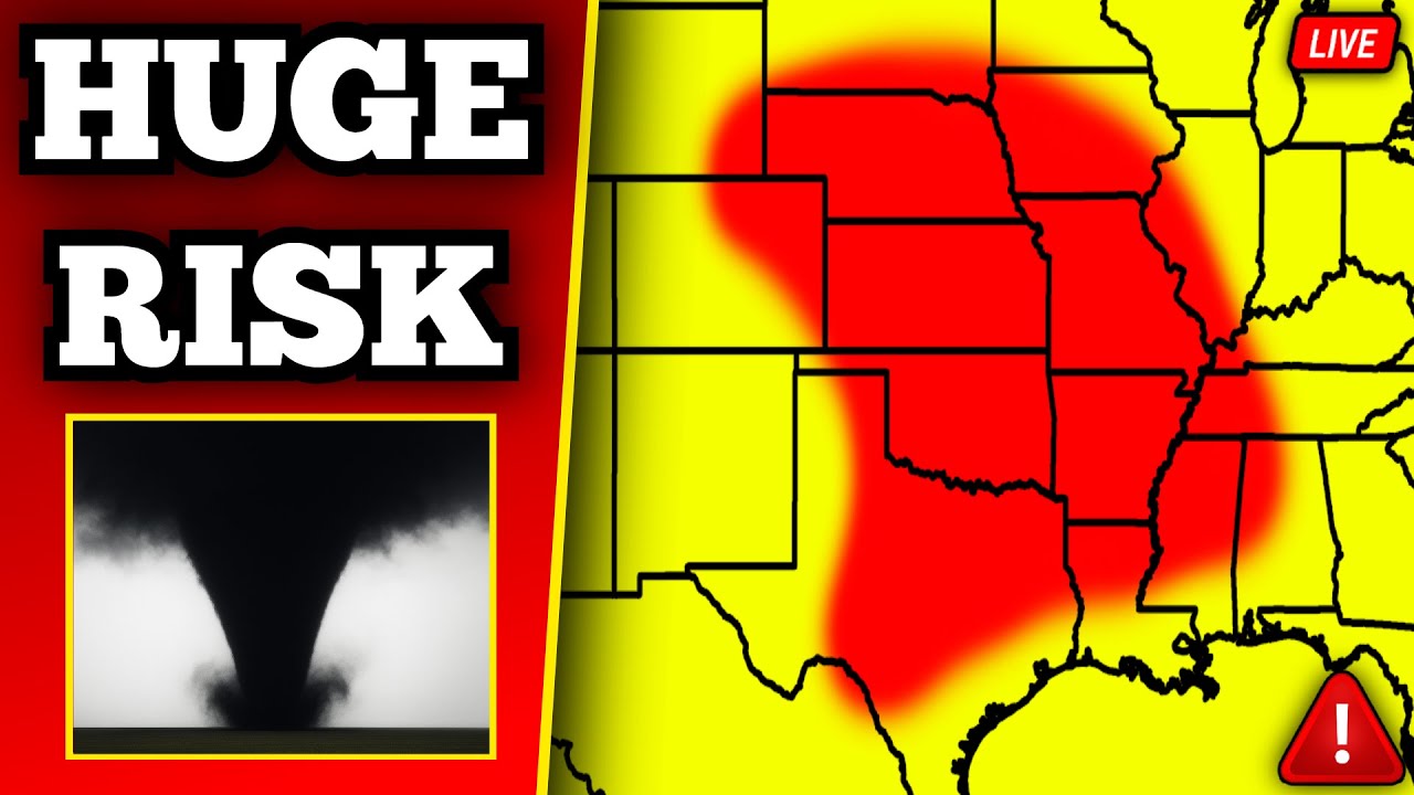
🔴 BREAKING Major Tornado Outbreak Coverage – Strong Tornadoes Likely With Live Storm Chasers
Alrighty, welcome back everybody to our latest severe weather coverage. Hope everybody’s having a good afternoon thus far. Uh we are going live right off the bat with a tornado on the ground in Colorado. This is just off to the east of Denver. Uh this is actually a relatively large tornado. It’s been on the ground for the last several minutes. You can see the velocity couplet. It is huge right now. Uh just off to the east of Highway 79, currently going up towards Living Springs, Colorado, just off to the north of Bennett. If you are in this tornado warning, you need to be in your safe place immediately. Get away from windows and get on the lowest floor possible. Uh part of this is actually not in the tornado warning as of right now, which is uh kind of concerning. The tornado is actually now moving outside of our tornado warning polygon and it is a huge tornado. You can actually see the hook echo extending out from the supercell and it is currently tracking up towards Living Springs. We also have a large debris signature right now moving off to the northeast. You can actually see if we go to the live shot here in Bennett, Colorado. You can see some of the dust there on the left side of your screen being picked up. And that is from this tornado here over the last few minutes. It is currently tracking in the direction again of Living Springs. So, if you are in the tornado warning or just outside of it in Living Springs, Colorado, uh you’ve got to be in your safe place. This is also another live shot. You can see on the middle middle left of your screen still a big plume of dust there. That is from our tornado here just over the last few minutes. It is currently again tracking up towards Living Springs. This is also another look at this tornado here in the last couple minutes. There are a lot of different shots of it. Uh this is just moments ago. You can see the tornado. It was a huge rope. It was also a lot larger than this uh just a few moments ago and it could actually be recycling as it continues to track to the northeast towards Living Springs. A new tornado warning has been issued. They have just issued a new tornado warning on this. Um again, if you are in this new tornado warning for Adams County, Colorado, you need to be in your safe place away from windows and on the lowest floor possible. Uh once again, very dangerous tornado right now. Currently tracking to the northeast. Velocities on radar are very strong. This has actually produced multiple tornadoes. Now, if we go back on the radar a few moments ago, you can actually see we had two different couplets on radar. And the new circulation is a lot stronger. Currently heading up in the direction of Highway 39. So again, this is currently tracking to the northeast. It is a very dangerous storm and it could easily produce another large tornado over the next few minutes. Uh again, if we go back to the live shot, you can still see there’s a huge plume of dust there on the middle of your screen. Looks like a funnel as well. I think this is a non-condensed tornado as of right now that is still picking up uh debris. Uh looks like we have another camera with the tornado. Give me one second. We’re going to add this. There is a another view of this tornado. It looks like one second. Got to add this. This is uh mile. Okay. So, this is on I7 mile marker 309. We’re have it up on screen in two seconds. Just give me one second. There’s a lot of different traffic cams here with this view. And yeah, this is a big tornado. Look at this thing. You can see it right there in the middle of your screen. That is a large tornado right there in the middle of your screen. Uh again, currently moving up towards Living Springs. The velocities bottom right of your screen are still very strong. Again, large tornado currently heading towards Living Springs, Colorado. That is a huge pipe that is currently down. Uh again, right here on I7. This is looking northbound on I7 at mile marker 309. Uh again, large tornado in the middle of your screen. This is a live shot of this tornado heading towards Highway 39. It will eventually go towards Living Springs, Hoy, and eventually Wiggins. Those are some of the next locations in the path of this. This is again a large tornado currently moving to the northeast. Wow. Uh there’s another Oh my goodness. There’s another live shot of this. This is even crazier. Give me one second. I’m pulling it up. This is an even crazier shot of this tornado. Oh my goodness. Look at this thing. Wow. This thing is a huge tornado right now moving towards Living Springs, Colorado. Bottom right of your screen again is the velocities couplet. This thing is huge. This is again live. This is on mile marker 299. uh looking north as well on the on a traffic cam here. There are multiple live shots of this tornado. Every single camera has it now. Oh my goodness. Look at this thing. We got three different live shots on the bottom of your screen. Actually, I’m going to change the second one. Oh my goodness. Every camera has this right now. This is a huge tornado right now moving towards Living Springs. The velocities on radar are very strong. I’m pretty sure this does meet PDS criteria as well. So, uh, again, this is a very dangerous tornado currently moving to the northeast, heading towards Living Springs, eventually going towards Hoyet, just south of Wiggins. It will eventually go towards Fort Morgan. This is a very discreet supercell. Uh, so this could easily be producing a tornado for quite some time as this continues to move to the northeast. Once again, large tornado is currently in progress here in Colorado. This is just off to the east of Denver. Velocities are still very strong on radar. This is likely going to continue for several minutes as it continues to move to the northeast. Um the tornado warning for whatever reason says radar indicated on this new warning. Obviously this is on the ground. This is a large tornado uh potentially a intense to potentially violent tornado right now moving to the northeast. Uh you need to be in your storm shelter, basement closet or bathroom. Again, if you are in Adams County, Colorado, this another shot of that tornado as well. You can see again it’s actually kind of roping a little bit down from the top left going down towards the middle. A little bit of a rope shape to it. So there’s a chance that this does rope out again and uudes and creates another tornado. Uh, this has already cycled a few times and it’s possible that we get another meocyone handoff as this continues to move to the northeast. Still a large tornado though in progress. This is quite literally unbelievable. See what this camera shows again. Yeah, that’s still another live shot. That thing is just a big pipe. Let’s hope nobody’s being hit by this tornado. Unfortunately, there are farms out here. It’s coming up on 88th Avenue, also heading up towards Living Springs. Also, this is a shot. Let me just show you real quickly. This is on the bottom side of it. You can see all the dust from the backside. This thing is lifting up tons of dust. See all the dust circling as well there on the screen. Apparently, there’s another live shot. Let me try to put this one up. Let’s go back to this live shot. You can still see the tornado. It’s becoming less condensed. Again, I do think there’s a chance that it is right now accluding. It looks like it’s been roping out here over the last few minutes. Still a tornado in progress though. Currently heading towards Living Springs. Let’s go back to that two or is it one? This another live shot. You can still see the tornado. There was just a cloud of ground lightning strike there on the left side of your screen. This thing is still going. Radar’s just updated. We have a big debris signature, by the way. There’s likely been some sort of damage. Either that or just a lot of dust being lifted up right now. Uh latest scan is still showing a large area of uh debris and that’s likely all the dust that we’ve been seeing kicked up here over the last few minutes. So, that’s actively happening here. This is again currently tracking towards Living Springs, Colorado. This is going away from the camera for the for reference. It is going north of the interstate. So, it is no longer going in the direction of the camera. It’s been going away from the camera. You can also see this is another live shot a bit closer again near Bennett, Colorado. You can see all the dust right there still being kicked off the ground. You can still see barely that kind of uh tornado coming down. It’s not as intense as before. I do think it is oluding right now. Uh but I do think it’s going to hand off again and we could get a new tornado as this continues to move up towards towards Hoyet over the next few minutes. Uh this has been quite unbelievable though. This has been on the ground multiple times in the last 20 minutes. And uh it is currently tracking towards Hoyet and also going towards leader. This is a uh and you can still see it roping out. You can still see the rope going all the way up. It is still on the ground picking up tons of dust. It’s being kicked off all over the place here. This was moments ago as well. That was a view of the tornado from the mile marker 299 here uh back over just north of the interstate. Unbelievable looking tornado. It’s been a stove pipe for the last several minutes and it is still going. Uh you can barely still see that shape there. It’s in the middle of your screen. Middle middle left or middle right, excuse me. It’s still on the ground here. It has not given up quite yet. This actually another. You can still see it here too pretty clearly. This is an emergency alert. A large and strong tornado is on the ground. Seek shelter immediately. All right, this is now officially a particularly dangerous situation. This is a large and extremely dangerous tornado. Currently tracking in the direction of Hoyet. If you are in this tornado warning, you need to be in your safe place. Get away from windows, lowest floor possible, and get to an interior room of your home or building. They have upgraded this to a particularly dangerous situation. The velocities are still very strong right now. Uh just to the north of Bennett, coming up towards Living Springs in Colorado. It’s eventually going to track towards Hoyet, just west of Leader. You need to be in your tornado shelter, your basement, your closet, your bathroom, wherever you can get right now. This is a large and extremely dangerous tornado that is tracking to the northeast. We’ve had again multiple shots of this tornado just over the last few minutes. It is pretty much It is a stove pipe. All right, it’s literally a stove pipe here that is currently tracking to the northeast. It’s not nearly as large as before, and it’s not as condensed as before either, but it is definitely still down. You can still see all the dust that’s been kicked up and that’s spreading out over probably 2 to three miles here. uh tracking right now to the northeast. Uh let me go back over to this camera shot. This one’s in a field. Uh let’s go to cam three here. And you can still see all the dust being kicked up. It looks like the tornadoes down more on the left now. Uh can’t fully tell there, but it looks like it’s a non-condensed tornado there further off to the left here. And so this is again going towards Hoyet, Colorado here over the next several minutes. And apparently there’s another camera with a funnel. So let me pull that up. There’s definitely a funnel still. It may be a non-condensed tornado currently tracking off to the northeast. One second. Repul that traffic cam. Let’s do this. Yeah, I think this is the view. I think we already have it on. This is the live shot here. You can still see the the lowering there on the left. It’s just a huge plume of dust right now. I don’t see a clear condensed tornado as of right now. Uh but there is obviously a lot of dust here. The visibility is very low now. And I do think right now this storm is recycling. There’s actually a new couplet attempting to form uh just in the north of Strasburg. So there’s likely a new tornado forming right now. So we have a live shot of this tornado attempting to reform just to the north of Bennett, Colorado. Keep in mind that this is uh this is technically our only tornado warn storm right now. It’s this one east of Denver. So, this is likely going to drop a new tornado as this continues to move northeast. I’ll have that bottom right of your screen. Uh Riley has an update. Go ahead, Riley. Hey, Max. I did just want to point out because it looks like this tornado is weakening. Uh this tornado has been on the ground for about uh 23 miles now on and off. Uh there’s been four different separate tornado reports. And I also think that we could see tornado potential extend further out the boundary. So, we kind of see a hook where a tornado is now. There’s actually a boundary that goes further off to the east from that and we could see the um vorticity of that spin up a land spout or two. So I’d be careful um where the couplet is and also further off to the east of that. I think that’s part of the reason why this tornado warning is so large just because there’s so much vorticity in the atmosphere. We could see land spout spin up in addition to our meocyonic tornado. Thank you Riley for the update. We actually have a video that was just sent in by one of our uh viewers of this tornado. This was back when it was near Bennett. So, this was before it became this large stove pipe. And um you can see clearly, I mean, that’s obviously a a pretty decently, it’s not a huge tornado, but you can see all the debris being kicked up, but that was what we call a non-condensed tornado. We have this big spacing between the condensed area here at the top. That’s about, you know, half way down here from the uh the lowering. And then also, this is all the debris that’s being picked up. And you can see all the people on the roadway. And obviously, you know, there are a lot of people that do travel here in and around the Bennett area. So, this definitely comes probably as a surprise to some. And this is literally just one storm. There’s nothing else in the area of Denver and it kind of came almost out of nowhere. So, uh, pretty crazy stuff here. And right now, this tornado is currently tracking towards Hoyet. The velocities are ramping up again. So, I do think a new tornado is going to be dropping in the next few minutes. If we go back on the radar evolution here, it is literally unbelievable. So, if we go back on the velocities, you will see this area of convergence come together back down near Parker. This is when we had our first tornado. Look what happened. We had a strong tornado just east of Senator. And then eventually we had another one drop right here south of Watkins. Another one dropped right here over Bennett. And then two dropped at the same time north of Bennett. It might not be clear cuz I’m a little bit more zoomed out, but you can literally see that there were several tornadoes here with this storm. And this one was the most intense by far near Highway 79. And it looks like a new one is trying to form now back over in Living Springs. So this is obviously a very dangerous situation. And this storm is definitely going to be packing a punch uh with tornadoes probably for quite some time. And the Storm Prediction Center has just gone ahead and issued a tornado watch which uh does not actually I don’t think include where this tornado is. If not, it’s just barely in it now. Uh but for areas in northeast Colorado, northwestern Kansas, and southwestern Nebraska where a few tornadoes are likely, this goes until 8:00 tonight. Uh definitely a dangerous area to watch for today. We have a lot of stormchasers actually in route to this area. And this will not be the only storm that’s tornatic in this area today. There will be several other storms that are tornatic. And uh this is just one of many. I mean, we’re going to have a bunch of supercells, I think, firing up in this entire area. You can see Connor Croft, Storm Intermedia, all currently in route for this area. And we also have stormchasers further down to the south where we’re also expecting the potential for a tornado outbreak. And we’re going to go way more in detail on that here in just a few minutes. Back to live radar right now near Living Springs. Again, the initial tornado that we’ve had has lifted, but I think a new large tornado is imminent. This is going to be moving again towards Hoyet, Colorado, and Highway 52. We still have a pretty good view here of this storm. Um, this is again currently a live shot. You can see how ominous the skies are. The camera is currently moving a little bit. They’re just trying to look at the entire storm. Uh, this is again currently tracking off to the northeast in the direction of Fort Morgan. That is a pannedout view here of this entire storm. I think they’ll go back to where that lowering was, the area of interest, uh, in the next couple of seconds here. And a little bit further to the right. And there you go. So, this is the storm, what we’re looking at right now. And by the way, if you guys have any photos or videos, you can ask us on Twitter, Max Velocityw. This is uh, again what the storm looks like right now. You can still see the cloud base right there. There is still lowering here. And again, this could drop a tornado as it continues to move to the northeast. This is also moments ago. James Pettis was able to capture this with a traffic cam and you can see this is what it looked like just a few minutes ago. I mean, that thing is a was a huge stove pipe. Uh, and hopefully nobody was hit by this, but there were likely at least some farms, if not even possibly some homes that were hit by this uh in this area. And look just how this thing spun out and roped out. That is unbelievable. And this is a time lapse, by the way. I That’s just unbelievable. That’s weather for you. I That’s That’s literally weather. That’s literally insane. By the way, in reports, if you guys have any traffic cam stuff, uh, send it to me. There’s also another view of this from earlier. Um, let’s go back to Let’s go back to radar first. So, latest scan still showing an area of rotation right now near Living Springs. This is again trying to drop a new tornado. Uh, we are keeping a very close eye on this. Bottom right of your screen is really the best live shot as of right now. Uh this is currently tracking in the direction of Hoyet, Colorado. Again, east of Denver as of right now. Uh so if you’re in this warning, again, continue to stay in your safe place away from windows and on the lowest floor possible. Uh Riley has an update. Go ahead, Riley. Hey, Max. Unfortunately, we are talking about a very large area today. We’ll get that risk covered uh later, but closer in our moderate risk, we do already have a storm producing very large hail west of Witchah. It’s warned for golf ball sized hail, but I would be uh I wouldn’t be surprised if it’s producing bigger than that. at uh the decibb on the reflectivity are already reading upwards of 70. So there’s probably baseball sized hail with this storm. It just crossed over Highway 54 going to the north. The storm to its south is probably going to be a hail producer as well. This one should take a right-hand turn and turn into Witchah. So if you guys are in Witchah, Kansas, go ahead and be prepared for a uh hail storm in that area. All righty. Thank you, Riley, for the update. So that is again back over west of Witchah. Our first really big hail storm of the day here. currently moving off to the northeast. It’ll be heading towards Newton. This is likely producing greater than two inch sized hail right now. So, if you’re in this area, definitely make sure that you’re protecting your vehicle, staying away from windows as well. Back over in Colorado, again, we are still waiting for the storm to recycle. I think it’s moments away from dropping another tornado. It’s currently tracking again towards Hoyet and eventually towards Wiggins. We don’t have any damage reports quite yet from this area, but again, I would not be surprised if we at least have a few uh with the intensity and the magnitude of this supercell and what we just saw here over the last few minutes. Uh we have another uh video here from a few moments ago. Let me try to get this up here. Uh this was another video from moments ago of this tornado. Live shot here. And there you go. So this another traffic cam and this was in real time. This was not a time lapse. And you can see all the dust being kicked up and the tornado there in the middle. Uh that is obviously again a huge tornado here. That that was moments ago on this traffic cam. Uh looking I believe this is westbound or no this is actually looking no this is looking westbound uh back at mile marker 302. So this was only about 10 15 minutes ago basically when we went live just before we went live as well. Quite literally unbelievable. You can just see it right there. A huge dust field right there. And it actually was only about probably a half a mile from this camera. By the way, look at everybody going on on the road here. Look at everybody on the road. I like all these people are traveling on the interstate. Probably had no clue there was even a tornado up until they saw it. Uh cuz again, this storm basically came out of nowhere. Uh Riley has an update. Go ahead, Riley. Hey, Max. Unfortunately, we are already seeing damage reports. Uh we’ve seen uh don’t know where they’re from actually, but we have seen a roof be ripped off the building. So this was definitely a significant tornado. Um it’s obviously no longer on the ground, but if it does produce again, it could also be a significant tornado. So take any downstream warnings very seriously. Hey Riley, for the update. Latest radar scan is showing a couplet once again. Very low reflectivity area. Uh this is an area that we will probably see more photogenic tornadoes today just in this general vicinity. Our surface low is literally located over the Rockies. So this is a very high area of vorticity and also wind shear. And with that said, we are probably going to continue to see this produce more tornadoes as it moves to the northeast. Hasn’t produced a tornado probably in about 10 to 15 minutes. In fact, they just downgraded the warning back to radar indicated, but this is likely about to drop something again as it continues to move towards Hoya. We still have an area of strong rotation. Uh all three cameras again at the bottom of your screen are looking at this storm. We’re going to go full cam to at least one of them here. Uh let me go back to cam one. And it kind of looks like on the left side of your screen that might be a funnel trying to develop there. I’m not 100% sure yet. Um, but that looks like maybe the area of interest right now. And this is also a little bit more zoomed in. What’s interesting is on the bottom of your screen, you can still see all the dust that’s being kicked up from that initial tornado that is still moving uh to the north. And I honestly think that is a funnel on the left side of your screen. If not, just some sort of sus clouds there. But that might be the area of interest right now. Velocities on radar have been intensifying again. And we have another velocities scan coming in here in just a second. So awaiting that. So this is currently again located in Adams County, Colorado. We’ll probably get a new tornado warning here in a second, but left side of your screen starting to look a little sus. A new tornado warning has been issued. They have issued a new tornado warning. This one’s going to be for Morgan and Adams counties. This is going up towards Wiggins and Highway 70 or Interstate 76 in the uh near term. If you are in this tornado warning, seek shelter. It’ll pop up here in a second. There’s also a terminal radar site that shows the velocities. Yeah, there’s definitely a large area of convergence still. This thing is definitely still trying to drop a tornado. Large area of broad rotation at least from this radar site. Might even have a little tightening there near Leader. We’re just waiting for the other radar sites update here. So this tornado warning again for leader in Hoyet in Colorado. If you are in this tornado warning, seek shelter, get away from windows, get on the lowest floor possible, and get to an interior room of your home or building. This is again currently tracking to the northeast. It will be moving northeast here at about about 25 mph. Fort Morgan and uh Brush are next in line for this uh as it continues to move to the northeast. And I’m not seeing anything definitively here. It looked like there was a small funnel a second ago on the left side. I don’t think it’s there anymore, but there’s definitely a lowering still here. And I don’t think this is far from trying to drop another tornado. Velocity’s on radar. Uh there’s still a little tightening maybe just east of Living Springs, but it’s a little bit broader of circulation southeast of Comanche. You can still see the hook echo on radar as well that’s extending out pretty far from our supercell. And again, it could drop another tornado as it goes up towards Hoyet over the next few minutes. But again, this is no longer a PDS tornado warning. It is back down to radar indicated. Tornado watch is in effect here until 8:00 for this entire area. We are expecting many more supercells to fire off in this environment over the next few hours. In fact, the HR model uh for today has looked very concerning for a lot of places, not just Colorado, but literally across the board. This is one of the most recent model runs. And you can see how many discreet supercells the HR has firing off here right around 4 to 5:00 stretching from Colorado and Nebraska all the way back over into central Oklahoma. Uh this is quite literally an unbelievable look on a computer model. We don’t usually see stuff like this. Uh if for some reason this scenario pans out, we could be talking about a full-fledged outbreak of tornadoes today across the central and southern plains and even back up towards Colorado where we’ve already had a large tornado. And honestly, that large tornado kind of came as a surprise. I don’t think really many of us were expecting a tornado uh in, you know, Colorado just east of Denver at 3:00. So uh this would basically be worst case scenario here as we go late into this afternoon and into the evening. Anything that you’re seeing here like these little ovals, those are updraft hallicity tracks. Basically meaning any of these storms that are on the picture here are something that’s rotating. So there’s something rotating here literally with any one of these supercells. And uh in this environment and if these storms are able to push out long enough uh basically meaning they fire off here in the next hour or two, we’ll probably end up seeing multiple strong or even long track tornadoes here across the board. And uh obviously this is very concerning. This is not what you want to see and let’s hope this scenario does not pan out. Uh but if it does, it is going to be a very long afternoon and evening. And this is even the more recent HR model run still showing a very similar scenario across the board. So yeah, that is definitely a concerning look right now. Also, we have a new SBC outlook for today. This is the 3:00 update just came out. Um and obviously if you’ve not already heard, yes, we have a moderate risk of severe weather today. That was upgraded from this morning. That is across southern Kansas and northern Oklahoma. enhanced risk goes back up into western Nebraska, northeast Colorado, back into North Texas. In addition to that, there is a threat of strong tornadoes. They have grown the 15% hatch tornado risk to include a larger area here uh including areas just to the west of Witchah and just to the north of Enid Enid uh in Oklahoma. Additionally, large to very large hail is another big concern. We’re probably going to be talking about some giant hail here uh throughout the afternoon and evening hours out of these supercells. So, make sure that you’re staying weather aware, protect your vehicles, be ready with a tornado action plan ready to go. It is going to be a long afternoon and evening. Back over near Witchah, we do have a severe storm here. This is not really something tornatic by any means right now, but it is producing some big hail uh currently coming up near Park City just on the northwest side of Witchah. So, if you are in this warning, continue to stay in your safe place. It’s currently warned for golf ball sized hail. Back near our dry line, which is where storms are going to initiate soon. Uh we don’t actively have anything in this area that has developed, but within the next hour or so, I do think we’re going to start to see some supercells bubble up here across western Oklahoma. And then back over in southwest Missouri, northeast Oklahoma, we have some elevated storms continuing to produce hail. Uh but overall, these are not currently uh anything that I would expect to be very tornatic here in the near term, but it is still something that we need to keep a close eye on as they continue to go towards Springfield, Missouri. All right, back to our tornado warning. Uh latest radar scan still showing an area of rotation right now east of Highway 43. This is as of three minutes ago. A new radar scan is coming in as we speak. So we’ll see what it looks like here in a second. This what our supercell looks like. Again, this has now produced at least four different tornadoes in the last about 45 minutes to an hour. Still have a hook echo extending out from our supercell. And the velocities right now are still on the uh or at least are starting to strengthen right now. Moving to the northeast. We have a photo of damage. Uh this is from Riley Winters on Twitter. This is some of the damage back over in Watkins or Bennett, Colorado. So this is some of the initial damage that we are now getting here out of Colorado from this tornado. That looks like a solar field farm that took some big damage here. And another photo here of it looks like a home that has been at least partially damaged. Looks like part of the roof. And a lot of trees are down as well. and sheet metal also stuck up into a tree and then more damage here to that solar field. So, unfortunately, there is damage from this tornado. It literally crossed over uh Interstate I think it was what was the interstate here? We’re the interstate already. Uh Interstate 70. It crossed over Interstate 70. This is your tornado track. We had multiple tornadoes once again. Uh but this was the general area of where we had multiple tornadoes and so unfortunately Bennett, Colorado did take a hit from this tornado and it is continuing again to move to the northeast. Uh we are getting a report that there is a new tornado or at least was in the last couple minutes. Um let’s go back to the live shot here. I’m not sure if it’s still on the ground, but there was a report a few minutes ago of a new tornado that dropped maybe briefly. Velocities on radar are still not looking super tight right now, but if this thing can tighten, we’ll probably get another tornado. You can still see the wall cloud there on the left side of your screen. So, this thing is still attempting to drop a tornado moving to the northeast. It’s going up towards Hoy right now. Lots of ranches in Colorado. Yeah, unfortunately there is a lot of farmland as well out here, but you can definitely see the wall cloud on the left side of your screen. Again, I think this thing’s trying to still drop a tornado. I don’t think this thing’s done. And uh this is one of our best shots of it right We have a couple other cameras at least from the uh Colorado traffic cams that have a view of this. So, we’re keeping an eye on those. And once again, if you’ve not already seen the tornado, uh again, we probably shown you this multiple times. This is just unbelievable when it comes to weather, but this was again not now, but this was about 20 minutes ago or so. This one, the tornado was right next to I7. And again, it was a huge tornado and it roped out. And this is one of the craziest things that you’ll see in meteorology is seeing a tornado rope out just like that. You know, it literally was a huge stove pipe. Then it starts roping out, gets that like curvature, kind of gets sheared off. And um yeah, I that’s pretty pretty crazy. And unfortunately, this did again cause damage at least to a solar field. And at least one home from what we’ve seen has been damaged by this tornado. And we will likely have uh more damage reports coming in here soon, especially with this area not really being a low population area back over in Bennett. I mean, it’s not like a huge city, but there are multiple homes here and as well as farms and ranches. So hopefully everybody’s okay though. Buildings can be rebuilt, lives cannot. Let’s go back to the live shot here. Still got a low wall cloud right now on the left side of your screen. Latest velocity scan still showing an area of rotation heading up towards Hoyet, Colorado. We’ll have another radar scan here in just a second. This happened just east of Denver in uh Bennett and in and around the area of Bennett. Again, there were multiple tornadoes. It was not just one. There was literally four different tornadoes. Hey, Douglas for the super chat from Crossville, Tennessee. Appreciate the super chat. Still got a wall cloud there on the middle middle left of your screen. There’s another shot that has a little bit better of a view, but it has a little bit more contrast here. Is Kansas at risk? Kansas is 100% at risk. Kansas is 100% at risk today. I I honestly You know what’s crazy? I actually posted this on Twitter earlier. Kansas has had four tornadoes in all of 2025. Believe it or not, all of 2025, you guys have had four tornadoes today. I think we’re going to at least double that number today. Uh, with our environment, like by 5 6 7:00, you can see there are going to be so many different storms out there. And, uh, any storms that fire in this environment will likely be rotating. If we look at our significant tornado parameter values for today across the board, they are very high and they are the highest across northern Oklahoma. So, uh, they are going to be very high here today. We don’t usually see blues at least when we look at the radar mega color table here. And um yeah, I mean the environment is very favorable. We have also a lot of again a lot of wind shear in this environment in general. This is a classic great plane setup for strong and even long track tornadoes. So I would fully expect that we are going to see multiple um tornadoes today especially in Kansas and Oklahoma. But I do think back up here in northwestern Kansas, you know, northeastern Colorado, southwest Nebraska, this honestly could be an outbreak just in general here. So, looks like this storm is still rotating a little bit. Um, on radar, the velocities are still there. I’m waiting for another velocity scan here. It’s about 3 minutes old. The storm is still rotating. And this did produce a large tornado, at least a few different tornadoes. Is attempting to try to drop another one here near Hoy, Colorado. And the latest velocity scan just came in. Still rotating. It’s not as much as before. We still have a large lowering there in the middle. Let’s go back over to the other camera, too. Multiple different shots of this. Still see that mezo there on the middle of your screen. Hey, Jay for the super chat. How’s DFW tomorrow? I think the main concern will be hail in Dallas for Worth tomorrow. There was significant damage in Bennett. Yes. Uh again, we’ve already seen some photos and in case you’re just tuning in again, this is some of the damage that we’ve had in Bennett, some to a solar field here, uh back over in the town of Bennett. Actually, there’s even more photos here. These are newer photos again from Riley Winters on Twitter. Uh more photos of the damage. And this is a close-up view of some of the damage, including solar panels that are completely shattered. These are not usable anymore. Uh you can even see some wood planks as well. Fence is completely damaged here as well. So, major damage. And this is honestly an ominous shot. I I hate when I we see photos like this where it’s like you got the storm right in the background and then all the damage left behind it. It’s one of the more scary kind of photos that you can see. And honestly, I’m not saying this is what happened, but I mean this does remind me like back when we had the Joplin tornado for example when all the people were all like the reporters were going to that tornado and then all you see is them with dark skies behind them from that, you know, really deadly tornado. And um you know, having a photo like this is just so ominous. But again, a lot of damage here in this field in Bennett. A big solar field once again. A lot of poles snapped. Lots of wood planks all over the place. I mean, these I would have to say probably at least half of those solar panels are broken and they’re probably not usable anymore. Looks like a towel or something like that right there, too. Another solar panel completely shattered. And wow, look at that sheet metal right along the pole. These are, I believe, telephone poles or power poles. And a little bit of damage to the roof here. That home looks okay. There’s definitely some damage there, but it’s not substantial. Man, oh man. Not a good start to today at all. This is a live shot of our tornatic supercell here near Hoy, Colorado. The velocities are attempting to intensify again. Starting to rotate a little bit. Looks a little scutty, but it’s trying. still trying. Hey Katie for the super chat. Southeast Wyoming also has to be on alert. Southeast Wyoming also has to be on alert today. There is a chance in southeast Wyoming for an isolated tornado and also very large hail. You’d still see it spinning a little bit. This camera isn’t like 60 fps, like you can’t really see every It’s like one frame a second basically, but um or maybe a couple frames a second, but you still definitely see the Scut. It doesn’t look super organized right now, but it is spinning a little bit. Velocities on radar have not been as intense, but we still have rotation over the town of Hoyet, Colorado, moving up towards Highway 52, just south of Wiggins. And this is still a live shot of the storm from one of the Colorado traffic cams. This more distant from Bennett. Still several live shots. Riley, if you see any cameras that have uh damage as well, let me know. I don’t know if any of them have any view of anything damage wise. Most of them are looking at the storms right now. Uh Riley has an update. Go ahead, Riley. Hey, Max. We just got a new meoscale discussion and um the images and reports chat, but uh this is one of the strongest worded metocale discussions I’ve ever seen. Um it includes a risk for greater than 4 in size hail and winds or tornado winds from 155 to 190 mph. Um, I would not be surprised if we end up seeing a PDS watch for our risk area today. So, um, this is like the watch to the watch. If you guys are inside the circle, be ready for the watch and be ready for a tornado warning should one be issued later on today. Hey, Riley, for the update. That is scary. And not just the warning, but look at the the probabilities here. Uh, these are some of the highest probabilities I have seen on a tornado watch or a mess scale discussion, excuse me. Um, most probable peak intensity for tornadoes up to 190 mph. For reference, that is in the ballpark of the potential for EF3, EF4 tornadoes uh that are possible here in southwest Kansas, western Oklahoma, and also the Texas panhandle. Greater than 4in size tail is also likely in this area. And notice the colors here there. There is a reason for these colors, by the way. It’s not because of the intensity. because of the likelihood of these happening or at least in the probabilities of like you know how high it could possibly get. Uh you know this is like one of the highest probabilities you can basically get on a mezoscale discussion and so there is a potential for a particularly dangerous situation tornado watch here. Uh again due points are already into the mid to upper 60s and low 70s. Temperatures are well into the uh 80s right now across many of these areas. So we are expecting the threat of significant tornadoes in this region today. uh just to kind of go over some of the wording on this mess scale discussion. Uh once we get the wording, I’ll let you guys know. It looks like it’s not up yet, but once the wording is up on this watch, we will uh we will talk about it. Is there wording on this yet? Whenever the wording gets posted, copy and paste it to one of the chat rooms. Um but yeah, again, they are mentioning that supercells are expected to form from western Oklahoma into southwest Kansas. Very large hail and tornadoes will be possible. So very dangerous day of severe weathers ahead and that again includes parts of Oklahoma. that is not what we want to see. Again, so far, if we go over to satellite imagery, this is a pretty important thing today is looking at some of our uh, you know, now features because, again, computer models only do so much with today’s environment. One of the things that we’ve noticed throughout the, you know, late morning and also early afternoon is that there has been some thick cloud cover, especially across Oklahoma. But look at all this clearing right here. Look at all that clearing across western Oklahoma and also the northeastern Texas panhandle and southwest Kansas. And also look at this cumulus field right here that’s bubbling. We are going to start to see supercells probably forming right along the Colorado and Kansas border over the next few hours. And then additionally, we are going to be seeing probably a bunch of supercells forming in this environment here soon. Assuming that the atmosphere can destabilize fast enough, which right now, yeah, you can see it is quickly destabilizing. Uh we have really little cloud cover right now in western Oklahoma. Little cumulus field is beginning to go up here. And so we should start to see some convective initiation within the next hour or two in western Oklahoma. And then back over in Kansas, this is a bit of a concerning sign. Storms are starting to try to bubble up right now back over in West Kansas and East Colorado. Is there a new tornado down or am I going crazy? You go back to multiple cameras. It looked like something. I don’t think there is one. Kind of looks like a little funnel still sticking out of the sky here. This back over in Colorado on our only tornado warning. The velocities on radar have not looked overly impressive recently, but uh there is still a hook on this storm near Hoyet. Just again tracking up in the direction of Fort Morgan. It looks like there’s a lowering. Uh Riley has an update. Go ahead, Riley. Hey, Max. I had that uh Metoscale discussion text pulled up now if you want to pull it up on the second computer. Uh the watch probability of course is 95%. We expected this, but I do want to note that uh they are expecting very large hail and they specifically note EF3 plus tornadoes. So the EF3 plus tornadoes, those are your violent tornadoes. Uh the reason for this is um we basically have a very very favorable environment. Our storm relative elicity values look good and um it’s only going to get better with the um jetream movement later today. Uh this is once again we’re expecting the peak tornado intensity today to be 155 to 190 mph, wind gust up to 80 mph and hail up to 4 in in diameter. So there’s a very very significant threat today and we need to be taking it seriously. Thank you Riley for the update. Once again, very strong wording from the Storm Prediction Center and uh there is a potential again for a major tornado outbreak that includes parts of Oklahoma and as well as Kansas. And we are expecting this to be again not just in those states, but those are like the two primary states this afternoon that we will likely be seeing some significant tornadoes in assuming that we get discrete supercells that fire and they also uh can maintain in this environment. We’ve had some again some thick cloud cover throughout the day across parts of Oklahoma. But again, that is starting to clear out and we should start to see some convective initiation here soon. Uh looks like we’re starting to see a little bit of some convection bubbling up just to the south of Dodge City. So I’ll have to keep an eye on that. Uh that’s back over just south of Dodge City, Kansas, west of Ashland. We also have a new severe thunderstorm warning for the city of Witchah. That is for golf ball size hail in addition to the threat of 60 mph damaging winds. That is also near Sedick, Newton, Bair, and Park City. So if you are in this area, make sure that you are ready again for the potential for large hail and damaging winds. The tornado risk for the time being is low. Uh it is it’s not zero, but it is low for right now, at least with these storms. But we’ll be keeping a close eye on these. Uh Riley has an update. Go ahead, Riley. Hey, Max. We have an update out of Adams County, Colorado. That is where our tornado was. Uh we’re receiving reports of significant structural damage to multiple homes, people missing and or trapped. It sounds like they have called in a state emergency managers and structure collapse teams from Aurora Fire and South Metro Fire into the region. So, um, unfortunately, it does sound like this tornado did do significant damage to occupied residents, and I will have more updates on that as the story develops. Thank you, Riley, for the update. That is definitely not what you want to hear. Uh, again, we’ve already had major damage in this area. This was again from uh Riley Winters on Twitter. And this is just some of the damage. Again, we we’ll probably have more damage photos as we continue to go throughout the afternoon, but obviously significant damage to this area. The majority of what we’ve seen so far is damage to a solar field. Uh there’s also been damage to part of a roof as well. Let me find that roof damage again. I’m going to see if there’s any other photos as well. We might have more now. Hey, um Riley ask see if we can do this one too. Yeah, this is part this is some of the roof damage that we had. Again, this is honestly there’s probably worse damage than this vid to guess, especially with the magnitude of our tornado. But you can see part of that roof uh you know that corner like kind of triangle part of the roof there was completely torn out. Um hopefully again that everybody was safe in this building as well. We had a lot of trees down, lots of power lines down by the looks of it too. Sheet metal went flying into trees. Anybody that was caught outside would have been in a very dangerous situation here obviously or even traveling especially with sheet metal flying around like this. That is obviously very d very dangerous. But again, this was in Bennett, Colorado. Uh, which is again where there is it look that from the sounds of it. There is currently people missing or trapped. So there is uh currently structure collapse teams that are ordered for this area uh in Adams County. Again, Colorado. Riley, you got the thing in Dibble, right? Thank you Kyle for the super chat. DFW tonight should be mainly a hail risk. So again, what’s going to be happening over the next few hours. Let me just go back to the future radar here. And again, you can watch the computer models inside the radar Omega app if you are a subscriber. Download it with the top link in the description. This one looks like as we get closer to 6 to 7:00. Again, we are expecting several supercells to fire up near our dry line. Just kind of giving you a zoomed out view here. This is our dry line right around 6:00. Many supercells are going to fire up in Kansas. Oklahoma. The HR R is not really bullish on right now, but I still think we’re at least going to see one or two storms in that environment. But notice back over North Texas, we’re actually going to have several supercells fire up here. These will be mainly a threat of hail, but there is a chance for an isolated tornado or two in this environment. And so that’ll be mainly a late afternoon and evening threat. If we go over to our SPC outlook for today, uh let’s go to the tornado probabilities. You can see we have a 5% tornado risk across Texas. So we’re expecting maybe a tornado or two. Uh strong tornado is not impossible. I know we don’t have a strong tornado risk technically in this area, but we could definitely see a strong tornado in this environment. Back over in Oklahoma, our 10% hatch tornado risk does go up towards Oklahoma City. Elk City, Woodward is also included in that just west of Bartlesville. And then our 15% moderate risk of tornadoes is in effect just west of Witchah back over near Hutchinson, Great Bend, and Hayes. And also near Dodge City where there is a potential for strong maybe even long track tornadoes this afternoon. And then back over in northeast Colorado, southwest uh Nebraska, and even northwestern uh Kansas, I honestly think we should have a 10% hatch risk up here. I’m surprised we didn’t get one. Um but honestly, in the next hour or two, we will probably end up seeing a couple strong or even long track tornadoes in this region. We already had one near Denver, and we might get another one. So, all right, we have another video from our tornado earlier back over near Bennett. Believe this is from or this is a photo. This is a photo of our tornado earlier. This is from Greg on Twitter. That was again back over uh just to the east of Denver uh near Bennett. This was one of the first tornadoes that we had. Again, this storm, keep in mind, produced four different tornadoes. This wasn’t the only one. Um, so this was one of multiple tornadoes that dropped and you can see it was a non-condensed tornado. You can actually even see some of the hail falling as well. But again, that is a non-condensed tornado debris being lifted up on the ground or actually it’s almost condensed, but um, yeah, pretty crazy look there as well. Also, the tornado warning is still ongoing here for a few more minutes. Let’s go back to radar. Let me get off this and let’s go back to live radar here. That’s what the storm looks like right now in Colorado. Still is tornado warn just to the south of Fort Morgan. Velocities over the last several minutes have not been as strong. There is still a small area of rotation uh that is heading up in the direction of Fort Morgan. But I do think this storm there is a chance it is a bit more outflow dominant. We can actually see an outflow boundary sticking out just to the east of this storm. And if that’s the case, it is going to struggle to produce a tornado. I think uh we can kind of see the storm still from these traffic cams near Bennett. That is a live shot. You can still see the storm out in the distance. I don’t see a clear lowering anymore, but still something we need to keep an eye on in case it does latch to that outflow. So, we’ll be keeping an eye on that. Hey, John from becoming a member. Welcome to the velocities. I’ve got an awful feeling about tonight. The setup seems very similar to May 4th of 2007. I’m I’m pretty concerned about today. I mean, obviously right now we don’t have any like crazy supercells other than the one in Colorado, but within the next hour or two, uh, I think it’s going to take off very quickly. I mean, we already have convective initiation beginning in southwest Kansas, and it’s only going to be a matter of time until these storms are at the height of actually becoming tornatic. So, I mean, it’s going to take a little bit of time, but they’re they’re definitely starting to fire up and get going. And then, uh, back over even in Colorado, we’re starting to see initiation, too. And then within the next hour, we will likely start to see initiation as well. uh back over in parts of western Oklahoma and then also in North Texas. So things are going to take off I think very quickly. Let me go back to radar here. I want to show you guys again just from a little bit ago. This was again our tornado tornado supercell here. One of the craziest things that you’ll see this storm produced several different tornadoes over east of Denver. One of which was just to the north of 186. We had another one drop here near 30 and then another one dropped way further off to the north and then another one drop near Bennett. I actually think there may have been twin tornadoes near Bennett at one point because we had two tight couplets on radar uh that tracked right up through the town of Bennett here in Colorado and then that continued for a few miles near 79 and then it oluded. So there was actually like again I think there were four different tornadoes here that happened uh just to the east of Denver and we are fortunate that this did not happen anywhere closer to Denver because there are a lot more people that live in Denver compared to Bennett. But even then Bennett has suffered damage and there are currently people that are either trapped or missing right now. Uh Riley thinks there’s a possibly five tornadoes, so he may have actually had five, which is pretty crazy. Hey, Denim for the super chat. I totally agree. Thank you Sam also for becoming a member. Can confirm here in Bennett there were two within a short period of time. Yeah, there were definitely I definitely think there were two. Also, shout out to Roger with the VM. You and Riley do a good job keeping everybody informed. Y’all have lunch on me. I appreciate that. Roger. Thank you for the VMO donation. Riley, do we have perms on that video yet or no? All right, we we have already posted some of these videos on our uh Twitter and Facebook pages. Again, this was from one of the traffic cams earlier of our tornado here just off to the east of Denver. And it gives you an idea of the intensity. And this is actually twin tornadoes, I’m pretty sure. I think that’s a tornado. And then this is right here. Um I’m like 99% sure that’s what that is. I could be wrong, but yeah, that looks like two different tornadoes. That that this is when we had twin tornadoes. So we had two tornadoes on the ground near Bennett. That is one of them back over in the distance. And that is the larger one that we had uh looking westbound on mile marker 302. Also, we just got a new tornado watch for Oklahoma and Kansas. And kind of surprising, we do not have a PDS tornado watch, but we do have a tornado watch across many areas in southwest Kansas, western, and central Oklahoma where a few tornadoes are likely. Widespread hail up to the size of apples is also likely. And then scattered damaging wind gusts up to 70 mph is possible. This includes a little over 2 million people here today. So, if you have any friends or family in this area, make sure that they’re aware of this situation. And uh definitely make sure if you are in this area that you are taking this seriously. have multiple ways to receive alerts and have a tornado action plan ready to go as we are expecting a very busy afternoon here across western and central Oklahoma and also Kansas and a little sliver of Texas in the panhandle is also included in this and there will be a watch I believe let me look at this here real quick and also I’ll have a probabilities on that watch here in a second but uh we will have a watch I think here soon in Texas uh my mouse just died that’s actually unfortunate my mouse just died while I’m live. Give me one second. I got to plug in my mouse. I’ve never had that happen before. Mouse dying on stream is actually diabolical. All right, now it’s good. I had to plug it in. All right. Um, what I was saying is that we we were supposed to get a watch in Texas actually not too long ago. They haven’t issued one. We had a mess scale discussion. Uh, once storms start to initiate, we’ll likely get a severe thunderstorm watch or a tornado watch for parts of Texas and uh anywhere basically from Witchaw Falls back towards San Angelo. So, that’ll be something that’ll probably come out here soon. And this is a live shot. Maybe, maybe not. All right. This is a live shot from Abene right now. You can see it’s actually kind of hazy out there. This is one of the Radar Omega cyclone ports. And if you download the Radar Omega app with the top link in the description below, you get access to all these different live cameras inside the app. Uh we’ll be keeping a close eye here in Abalene today cuz we’ll have storms initiating, I think, in the next hour or two with the main concern being large hail. But there is a chance for a tornado with any discrete supercells that do fire off. Uh there’s also one back up in the Center Ranch in German, Texas. You can see it’s actually pretty windy out in front of our uh dry line, which again I have had a lot of people ask me what is a dry line. It’s basically the divide between very humid and very dry air. That’s literally all it is. And that’s where storms are going to be initiating today. And you can pretty clearly see the dry line. I This is a very clear shot of our dry line here. uh due points very high off to the east of it in the 60s and 70s and then anywhere west of this white line it’s pretty much all in the 30s and 40s. So storms are going to initiate right along this dry line over the next few hours and we will likely end up seeing the threat uh for several tornadoes in addition to very large hail and some damaging winds. And one thing I do find interesting about today’s severe weather risk. If we look at the uh just general risk outline. Again, we have a moderate risk of severe weather. But more notably, the biggest concern is tornadoes and very large hail. We have a pink area outlined uh in near Witchaw, Great B, Hutchinson, and Hayes near I7. That could actually be for the threat of upwards of four to possibly 4 and 1/2 in sized hail today. Wouldn’t rule out a storm producing the hailstone size of DVDs as well. And then damaging winds is also a concern, but generally speaking, uh it’s actually not as great of a concern as you might think. This is actually pretty low for us having a moderate risk because this is a slight risk of damaging winds across the board. So, I thought that was kind of interesting with today. And by the way, if things don’t go crazy today, they’ll definitely be crazy tomorrow. Look at tomorrow. Huge enhanced risk. This covers about 18 million people across the central and southern plains. So, both today and tomorrow are probably going to be crazy. Uh strong long track tornadoes are also likely tomorrow. So, buckle up. It is going to be a very busy next 48 hours. And uh on Tuesday over in the Ohio Valley, we could also have an outbreak of severe weather. So it it could get pretty crazy here over the next few days. We do have a new supercell that is beginning to go up right now back over near Sterling, just west of Sterling here in uh Colorado. Not really rotating much yet, but it is out in front of the other supercell. This one may have a chance of trying to get tornatic at some point down the road. It’s very new. It is currently tracking off to the north towards Highway 71. We currently have Connor Croft in route for the storms. We’re going to put him on the screen. We’ll put him like bottom middle, I guess. Uh Connor’s in route. Freddy McKini is also in route. So, we got multiple stormchasers that are currently in route for these storms. Uh Riley, I need Freddy’s uh radar omega link. That tornado warning is going to be allowed to expire in 2 minutes, by the way. They It’s not on the map anymore. They are going to allow it to expire. So, back down to just severe thunderstorm warnings at least for the time being. Witchah, Kansas. We’re talking mainly about a large hail and wind threat right now. This what it looks like in Witchah. Um, which actually the severe warnings here for Witchah have actually been cancelled, but we had upwards of golfball sized hailfall in Witchah recently. One of the good things that we are at least seeing right now. This could easily change if our atmosphere destabilizes. But with these storms initiating out in front of our dry line, this could stabilize the environment at least for a couple of hours in Witchah. So, if storms do fire up a little bit later today, things could definitely get concerning. But at least in the short term, that is definitely a uh a good thing. But we’ll see if things start to get crazy here in an hour or two once storms initiate near our dry line. Once again, we are starting to see a couple little cells popping up right now south of Dodge City. So, we’re keeping a very close eye on these. Also, we do have a Let’s see. We have a new update of some sort. Oh, yeah. New NATO outlook for today. NATOCast is back. We haven’t had NATOCast in a while. They just brought it back. NATOCast is an experimental tool. Basically shows us the potential for tornadoes and how high that could possibly be today. And uh you’ll notice we have at least according to NATO, there’s a 15 or sorry, not 15, a 30% uh tornado probability risk outlined back over in central western Oklahoma. I’m not saying that’s going to happen, but generally speaking, NATO is usually pretty accurate. So definitely something to keep in mind. It also has that other high corridor back up in the northwestern Kansas and southwestern Nebraska quadrant. All right, tornado warning will officially expire in 30 seconds. Let’s go back over to where am I going? All right, let’s go back to Colorado here for a second. They do have a tornado possible label on the storm near Wiggins, by the way. So, there is still a TP label on this that is currently tracking again to the northeast. One second. I’m adding a Freddy over to our chasers as well here. All right, cool. We got Freddy on here now. Those cells popping off south of Dodge City are just the beginning. I agree. They are just popping up right now. These are going to probably get going here very shortly. Again, our dry line is set up basically right here. So these storms that are initiating, if they can scale here over the next, you know, 20, 30 minutes, we’ll probably have severe warnings and possibly tornado warnings here pretty soon. Hey, Stallion for the sewer chat. What should I expect in Armore, Oklahoma later today and tomorrow? I think the main concern down near Armore will be damaging winds and hail. Uh the tornado risk going to be a bit lower down here. Once again, if we go back to the future radar here over the next few hours, we are going to have multiple supercells firing up, but I think the majority of them will be either off to your west or to your north. And there will be a probably multiple that form in North Texas today in central Texas with mainly a hail and wind risk moving towards the Dallas Fort Worth area. Uh, but generally speaking, there is a chance too that nothing really fires in southwest Oklahoma. I honestly think we’re going to see something fire down there. Just again, models have not really been showing that here recently. If we go back a few model runs, we might actually see it. You can kind of see a few storms trying to fire up down there, but uh generally it’s kind of a 50/50 right now whether you’ll actually have storms within like 25 miles of you. So, we’ll have to wait and see. Do have a new severe thunderstorm warning just west of Marino in Colorado. That is going to be for uh 60 mph damaging winds, ping-pong ball size tail, and there is a tornado possible label on this. We have a if we have cameras near Sterling, let me know. I don’t know if we have any. Hey, Martian for the super chat. Thanks as always for the great coverage. Appreciate that. No problem at all. We got multiple stormchasers that are out there today. We got Connor Croft who’s currently now tracking into Colorado. You can watch him also inside the Radar Omega app. Connor and Freddy we are both working with very closely now. And Freddy will be on pretty much all of our streams. Oh, he’s loud. Okay. Uh he’s also on the radar Omega app now just south of KBY. And again, a lot of stormchasers are in route for this area where we could see multiple supercells fire up over the next few hours. We are beginning to see more convective initiation around Sterling, Colorado. And these storms could upscale pretty quickly and produce the potential for tornadoes as they move off to the northeast. So, this is definitely an area that we need to keep a close eye on over the next few hours. Again, strong tornadoes are definitely in play, I think, in northeast Colorado within the short term. We’ve also had some convection developing just to the south of I7. Nothing really crazy yet, but if any of these can get going, uh, we definitely could have some problems on our hands. There’s one storm currently towering up there just north of Cheyenne uh Wells. So, keeping an eye on that on video cameras. If there’s any good photos, let me know. Riley, thank you Gage for the super chat. My grandpa drives a semi is heading toward Ottawa, Kansas. There anything heading in the next couple of hours? Where is Ottawa? I feel like I should know where Ottawa is. Ottawa, Kansas. No, probably not. The greater concern will be later this evening. There could be a couple storms out there, but none of these right now are severe, and they probably won’t be severe for a little bit of time. Hey, LA for the super chat as well. Honestly, tomorrow looks pretty crazy. Again, today is going to be crazy, but tomorrow also looks crazy. If we go back over to the future radar here, I’m going to do the future radar for the next like 48 hours. Not just today, but also tomorrow. Uh cuz I want to show you guys what it looks like. Again, tomorrow also, I know we have a moderate risk of severe weather today, but tomorrow could also be really crazy. And I do think a moderate risk is definitely in play for tomorrow. And um again, it’s just going to depend more on storm mode and also how much morning convection that we have. This is what it looks like here over the next several hours for today. Again, the HR is showing multiple supercells across Kansas, Nebraska, and Oklahoma with all hazards of severe weather on the table, including large hail, damaging winds, and tornadoes. And then as we head into Tuesday, you’ll notice that we have more storms that try to fire up in the morning. None of these that concerning, but just after lunchtime, things start to pop off in Arkansas, Oklahoma, and southeastern Kansas with all hazards of severe weather on the table. And then notice how many storms are out there by tomorrow afternoon and evening. They are all over the place. But depending on storm mode, that’s going to really depend or basically whatever the storm mode is will really factor in to what we’re going to see in terms of severe weather tomorrow. We could have strong tornadoes. We could have a tornado outbreak. But if the storm mode’s a bit more linear like this, it’d be more of a wind, hail, and embedded tornado threat, which basically means it wouldn’t be as significant. But if storms can be more discreet, like they probably will today, then things could definitely get pretty hairy tomorrow. So, tomorrow definitely looks like it could be a big day, too. We are working on getting another video from the tornado earlier back over in Colorado. So, I’ll have another video here in a second of that. In case in case you’re just tuning in again, we had a huge tornado earlier in Colorado. I’m gonna find a video of the traffic cam again that we had on it. Also, Riley, can you put the chat on the uh other monitor in case you haven’t already seen this was the video from earlier. This is in Bennett, Colorado. This is our tornado that began today’s stream. It was a huge tornado roped out pretty quickly. We had four or five different tornadoes from this storm. And um again, this is probably what we’re going to see a lot of today. Hey Terra for the super chat. Also GE for the super chat. And unfortunately with this tornado, we’ve also had a bunch of damage come out of this tornado. Let’s see if there’s more damage photos, but we’ve had already a few. This is one of the photos from a solar field farm of significant damage in Bennett. According to one of the government sources in this area, I believe they did say um just east of Denver in Adams County, Colorado, there is significant structural damage to multihomes. People are currently missing or or are trapped. Uh state OEM is currently ordered structure collapse teams ordered from Aurora Fire and South Metro Fire. Um according to Colorado live events on Twitter. Uh so that is at least one of the reports that we have. Again, there is some structural damage to this area. This is so far the main tornado that we’ve had today. We’ve only had one or we’ve had like five, but this is the only supercell that’s actually produced tornado so far. Sheet metal caught up in a tree as well. And then also more damage here to a solar field. Lots of sheet metal there as well. This is again from Riley Winters on Twitter. Another closeup of that as well. How many screens am I looking at? We’re looking at five right now, but in about a month, we’ll have eight, possibly 12. We’ll be up to possibly up to 12 monitors here very soon. It’ll be pretty crazy. It’s probably the one of the weaker tornadoes that we see we’ll see today. I don’t know about that. This is definitely a stronger sided tornado. I mean, it was at least strong. It was at least a strong tornado. I mean, it could have also been intense as well. We don’t know for sure, obviously, but the the motion on it looked pretty crazy. Hey, Connor from the SE chat. Do you think the storm near Long Mount, Colorado may turn tornatic just off to the east of or just to the north of Denver? I don’t think so. This is kind of further back to the west. It’s also uh it’s going to be running in some rain cool air with the other supercell that we’ve had. So, I think this storm is not going to really produce any tornado threat, at least in the near term. Uh the main supercells that have any chance of producing a tornado in Colorado right now is the one near for Morgan, which has already produced multiple tornadoes, but has been outflow dominant for a while. And then the storm west of Sterling also has a chance to produce a tornado. We do have a little mezo on it just west of Marino and west of I76. So, we’ll definitely be keeping a close eye on this. I do think a tornado is in play with this as it continues to track to the northeast again in the direction of Sterling. So, we’ll be keeping a close eye on that. Hey, Riley, figure out who this is who that chaser’s through. Is there in northeast Colorado? Anyway, and for the super chat, any concern for forced tomorrow in Kentucky? Kentucky and Ohio is not going to see anything until Tuesday. We got a few cells attempting to go up right now in southwest Kansas. No success so far with these cells. They are very early on. Got a couple little storms trying to fire up. Also, I want to point out this. Let’s go to actually I could probably do this. Let’s go to this. Let’s go to HR. This is another thing that we look at for tornado threats. And this is our significant tornado parameter values. And in case you did not already watch our video today, we did talk about this quite a bit. Uh but essentially this gives us an idea of how favorable our environment is for tornadoes today. And we are currently sitting at about 4:00 central time now. Uh which is really when we’re expecting initiation to begin here across our dry line. And you’ll notice the values are already starting to creep up closer to, you know, 7 8 9 10. And notice the scale here. Uh the tornado parameter value scale is basically on a scale of 0 to 10. A lot of the time when anything’s lower than 1 or two, we don’t usually see strong tornadoes or at least the chances of that are on the lower side of things. Once we creep above 2 and three, our tornado threat is usually elevated or even in some cases significant. And even by 4 to 5:00, these values are pretty much maxed out here uh near our dry line in southwest Kansas and also northern Oklahoma. So if any storms can form near our dry line, we are going to likely see strong and long track tornadoes. Same thing goes even in North Texas and North Central Texas. Basically the same story over here where we could see some strong and long track tornadoes and then by this evening the values are even higher by 8:00. If for some reason we get a discrete supercell by 8 that fires near the dry line, which would be quite late, but if a storm were to fire around 8:00, just look at this environment. It’s honestly I mean it’s crazy how high these values are. is a classic great plain severe weather setup. So yeah, I mean today again has a very high ceiling. A new tornado warning has been issued. Very high ceiling for today. We do have a new tornado warning. This one’s going to be in uh Weld and Logan counties. We’ll have it pop up here in a second. It’s only our like third tornado warning of the day. I say only. We’ll probably have a lot here soon. Uh can you tell Hayden to add that chaser to the map, Riley? All right, here’s the new tornado warning. Uh this is west of Sterling. Area of circulation right now is near Willard. It’s currently tracking up in the direction of Highway 38. Again, rural area, but there are a lot of people um or a lot of ranchers at least that are in this area. So, if you are in this tornado warning, seek shelter just to the west of Sterling, Colorado. Again, currently tracking off to the north, just west of I76. So, seek shelter, get away from windows, and get on the lowest floor possible if you are in this tornado warning. Oops. Let’s do this. And where did Conor go? right there. All right. Am I suspecting activity in DFW tonight? I mean, I was yesterday and we didn’t see any activity in Dallas Fort Worth. So, I mean, maybe if I say no today, it’ll actually happen. But now, I I do think stuff will happen in in North Texas. I don’t know if storms will be that intense near Dallas Fort Worth, but uh I I do think it’s a possibility that we could at least get something over in DFW tonight. Hail would be the main concern, but if a storm stays discreet, the chances of a tornado would be a bit higher. latest radar scan. Rotation’s a little bit stronger now. Uh back over here near Willard. This could be some sort of contamination. I think that is just contamination, but that’s actually if that was rotation, that’d be anti-cyclonic. Might even have a little bit of rotation just west of Sterling. There actually could be three different areas of circulation right now. Uh just to the west of Sterling. I am going to see if we have any camera shots of this. Are some cameras in Sterling. They’re all photographs, but they might have a view of something. Keeping an eye on that. Hopefully, if somebody has camera control on those cameras, there’s one camera that has motion. If somebody has a camera control that might be watching the stream, um, you can somehow position it. That’d be lit. Uh, we have one camera that has a view of something. I really cannot tell what this is. Um, I’m going to send you the link, Riley, so you can give me the other link, but this is a live shot. That could be something there. This is again looking at our storm. I can’t really tell for sure. It’s just too blurry. Just a live shot of the storm here on I76, mile marker 101. Are again multiple areas of circulation here on radar just off to the west of Sterling. There might be something. Trying to get more. I’m just trying to get a clearer video. There are there’s a couple more video shots of this. This is another live shot. Just it’s impossible to tell really, I think. But like you can see how dark and ominous the skies are here. And um again, there could be something here. I I can’t really tell though for sure. Definitely one of those situations that if you’re in this warning, just be in your safe place and you know, at least prepare as if there is a tornado because there definitely could be. It’s very ominous here for sure. Back to the threecam view here. Latest radar scan still showing our main area of rotation just off to the northwest of Willard coming up on Highway 14 just west of Sterling. Currently moving to the northeast out here in Colorado. He is about to enter. He’s actually still in northwest Kansas, but he is going towards Colorado. We also have a new severe thunderstorm warning northwest of Fort Morgan. Broad area of circulation still northeast of Orchard, but mainly a wind and hail threat moving to the northeast. So, if you’re in the severe thunderstorm warning, be ready for that. We’re adding the cameras to the program so we have a better shot of these. Uh, this is back over in near Marino, Marino, Colorado. Let’s do this. All right. Bottom left of your screen is a live shot kind of looking at this storm right now. If they uh move the camera up more, I don’t know if they will, but if they do, then we might have a better shot of this. We do not have camera controls here. Just trying to verify and see if there is a tornado or not. And we also have Sterling. Let’s go full cam to Sterling. So, if there were a tornado, you’d probably be able to see it there at the top of your screen. I don’t clearly see anything. Just a little bit too distant. There’s a stormchaser that’s not far from the storm, but I think it’s going to they’re probably not going to make it in time. Huge shout out to Frell with the $50 super chat. Since tomorrow’s weather is going to be even crazier, here’s a little something for your Popeye’s addiction. If Riley is in the same location as you, please give him some lunch as well. He is not in the same location as me. Uh, what does Kansas City region look like for tomorrow? I think tomorrow will be mainly a wind and hail threat. If storms are more discreet, the tornado threat will be more elevated. Yeah, very top of your screen. It is hard to see. I I mean, there might be like a little lowering there on the right. They’re just not not clear by any means. Velocities on radar are not as strong either. There is a little hook on this storm, but I’m not very convinced that that’s, you know, tornatic quite yet. And we are starting to get a little bit closer to a little bit of a radar hole. Definitely ominous back there. My goodness. Look at this. This is crazy. You guys ready to see this? This is south of Dodge City. Look at this little storm right here east of me. You might think, “Oh, that’s just a little, you know, cell. Not nothing crazy.” There’s actually a mezzo. It looks like it’s already rotating, which is actually wild. It’s already rotating. It’s going to be It’s going to take some time for this thing to actually produce, but like it’s already rotating. We have a couple stormchasers in this area that we’re keeping an eye on. Man, that’s actually wild. A Teimu hook. It basically is. And there’s legitimately a Mezo on this already. And Aaron JJ’s not far from this. We’re going to keep an eye on him. This is back to the Colorado tornado warning live shot in Sterling. Bottom right of your screen is the little hook here south of Dodge City. I’m waiting for another radar scan. We’re going to go more in depth on this in a second. Hey Jimmy, for the super chat. Hard barbecue is so good. I miss heart barbecue. I haven’t been there in so long. I’d say the timeline for Argyle is going to be a little bit after sunset tonight. Sometime around like 8 to 12 would be my guess. Want to keep that bottom middle of your screen. Also, back over in Colorado, we got two storms that have now gone up near Cheyenne Wells. And Connor’s currently in route for these. And same thing with Freddy. So, we’re keeping a very close eye on them because these storms again could become tornatic here pretty soon. Um, if they’re able to scale up here. This is an environment where there’s a lot of vorticity, a lot of spin in the atmosphere. So, there’s definitely a chance of a tornado if these storms can grow in size. It’s not going to take much as I’ve mentioned a few times. Back on our storm in Kansas again. It is a really tiny little cell that is trying to rotate already just to the east of me. Time towards Minola and Fowler right now. also eventually going towards uh Dodge City. So definitely something that we need to keep an eye on. Connor actually I think already has a view of this bottom right screen. We’ll go live to Connor here. Connor’s on that little cell just off to the south of Burlington, Kansas. And I don’t think he’s talking. I hear nothing. There’s definitely a little base already to this thing. I don’t think it’s going to take a long time for this thing to get going. It’s just off to the west there of Goodland, Kansas. Uh Riley has an update. Go ahead, Riley. Hey, Max. Actually have two things for you. So, south of the Cheyenne radar site, we may have a spin-up tornado starting to wrap up near CAR um Colorado. Also, if we take a look at the violent tornado parameter on the SPC mezoscale analysis, it kind of points to us at why we may be seeing some of these small storms rotate. So, we talked about this yesterday and how we had really really elevated values of up to 17 and that meant that something significant could probably happen. Well, today we’re up to a 20 and uh we don’t normally see any of this purple color on the violent tornado parameter charts at all and it is off the charts in parts of Kansas and Oklahoma today. All right, and thank you Riley for the update. Uh back to live radar. As Riley just alluded to, we actually do have rotation right now near Highway 85 that is tracking in the direction of the Wyoming Colorado border. Little hook echo on this and an inflow. It’s more of a spit-up tornado in a line. Uh but there’s definitely rotation here right over Rockport. It’ll be going to rural areas here just east of Carr and I25. Uh but we’ll likely see a tornado warning on this here in the next couple minutes as that tracks up towards the Wyoming and Colorado border. We still have a tornado warning west of Sterling back over here in northeastern Colorado. I’m not seeing really anything definitively on radar, but keep in mind we could definitely see a tornado as this continues to track to the northeast. Uh bottom middle of your screen is still a live shot of this storm. I’m actually going to go full cam to this. Let’s do uh good. Let’s do full cam. You can see at the top of your screen. This is from Sterling. This is again for Logan County, Colorado. Low clouds, ominous skies. Can’t clearly see a tornado as of right now, but if we have one, it’ be somewhere at the top right of your screen. Uh Riley has another update. Go ahead, Riley. Hey, Max. This is actually about our um tornado outbreak a few days ago um when we had a bunch of tornadoes in Illinois. We actually just had an EF4 tornado with wind speeds of up to 190 mph get added to the DAT. So, this is a tornado that was south of Marian, Illinois. And uh yeah, 190 mph winds from this tornado. Wow. All right. Thank you, Riley, for the update. That’s pretty crazy. Uh if you if you have any damage photos of that, let me know. That that’s pretty crazy. EF4 tornado confirmed from our tornado outbreak, which again was a deadly tornado outbreak only a couple days ago. And um that was a rated EF4 tornado. Maximum sustained winds were 190 mph by the way. That is almost borderline EF5. So it was a very high-end EF4 tornado uh that was confirmed there in southern Illinois. That was our tornado emergency uh that happened there back over near Hudgens and just south of Marion in Illinois. That is wild. So yeah, that’s crazy. We had at least I think three or four EF3s as well. Let me let me double check the exact numbers. We also had we had a bunch of what day was that? May 16th. Let me get the exact number here. Uh we had from that deadly tornado outbreak, we at least had three EF3 to at least four EF3 tornadoes. So, and additionally at least seven EF2 tornadoes and all in total, we at least had 30 tornadoes on that tornado outbreak day uh just a few days ago. So, that’s pretty wild. That was a big day. And unfortunately, there was at least 30 fatalities at least confirmed from that tornado outbreak. This is back over just south of Dodge City. We still have a little mezzo on this storm near Highway 160 heading up towards Fowler in Minnola. We’re keeping a close eye on this. Bottom left of your screen, Connor is on a cell that is just developing west of Goodland, Kansas that is beginning to get a little messo on it. Uh you can see bottom middle of your or bottom left of your screen still a pretty good shot of that. Uh Freddy even has some dust being kicked up. It looks like this Freddy’s view of or Freddy pops up here. Freddy has a view of some dust being kicked up in an open field. What we got going on later this afternoon makes sense to me. It’s windy, so there’s some dust being kicked up. Got some high winds out there. We’ll be keeping a close eye on Freddy. Uh Riley has an update. Go ahead, Riley. Hey, Max. So, uh it’s the DAT is a little slow right now. Just I imagine they have so much people coming to look at this, but our EF4 damage indicator was right here near Quarter or Quarter Horse Road. And uh this was a two I believe a one or two family residence. The slab was swept clean. So this was a picture of the um house that was impacted at this tornado’s strongest intensity. And um we can just click through these p the pictures. Unfortunately, the um slab was slept clean. Uh the reason that this tornado was not upgraded further is what we’re looking at here is the video or picture of our um anchor bolts and these were just nailed to the ground. So, because this house was constructed with improper anchor bolts, that is why we did not see a higher rating. So, this tornado could have produced winds greater than 190 mph. Unfortunately, we don’t have the damage uh that shows that it did. So, that is why it’s received a high-end EF4 rating. Wow, that’s crazy. Thank you, Riley, for the update. Uh we have a new tornado warning that was just issued. That’s for Morgan and Weld counties in Colorado. pop up here in a second. But yeah, I mean, again, that was a crazy tornado. Again, if you’re just tuning in, that was an EF4 tornado two days ago. Uh, maximum sustained winds of 190 miles hour. Uh, that is literally nuts. And so, yeah, really, really crazy stuff there. Uh, where is the tornado warning? Well, I don’t know where the tornado warning is has popped up. That is interesting. There’s a data server issue or something. All right, new tornado warning is for All right, it’s going to be this storm back over here. So, this is just west of I76, uh, just south of Rymer, coming up towards Raymer right now in Colorado, just northeast of Fort Morgan. And we’ve had some rotation on this storm. It’s a large broad area currently tracking to the northeast. If you’re in this tornado warning, again, be in your safe place just north of Fort Morgan in Colorado. We will probably get another tornado warning, too, just south of Cheyenne, Wyoming. Uh or maybe not now. There has been rotation on this. It’s a little bit weaker on the latest scan that’s east of Carr. That’s currently tracking up in the direction of the Wyoming and Colorado border. So, if you’re in that area, continue to stay in your safe place. Uh there is still a dangerous storm there. Going back over to the southwest of Goodland, this storm is starting to ramp up a little bit again near Highway 385. Currently tracking towards Burlington. It is rapidly developing into an organized supercell and it could be a tornadic supercell at some point here not too long from now. This is Connor Croft currently looking at this storm in a second. So you can see the base there starting to organize a little bit on this now. Conor is also on YouTube. that the lack of initiation directly between here and that one down by Syracuse. He’s also on the radar app. You can download Radar Omega at the top link in the description in between Sharon Springs and Trabune. Yeah, I guess that’s a good point. I mean that one where’s that one would be in line for Oakley. The one down there. How’s my voice? My voice is doing pretty good. It’s It’s doing pretty good. It was actually a little bit bad yesterday, but it’s it’s doing good today. Ready to go for an outbreak today and tomorrow. Yeah. I mean, I’m keeping a close eye on that one. I think that one’s probably the storm of the day. have a little blip by Sharon Springs now, but yeah, it’s kind of a tough call. Here are the current uh warnings. By the way, uh again, our tornado warnings are both in northeastern Colorado right now uh near Raymer going up towards uh Highway 14 and then the other one’s just west of Sterling. Bottom right of your screen is still a live shot from Sterling of this storm. There hasn’t really been a whole lot on this cell. uh still have a little messo tracking up right past now Highway 14 going into rural areas now of uh Logan County and our other tornado warning still for Morgan and Weld counties. So that’s again currently tracking to the northeast. We also have a new severe thunderstorm warning in Kansas uh north of Witchah. If I can get this button to click here. This near H west of Newton. This is not a this not really a storm that’s going to be producing a tornado threat anytime soon. More of a hail concern. currently moving to the north about to cross over I 135 eventually going in the direction of Abalene and Junction and then back over in southwest Kansas. This is where we’re beginning to see some storm initiation. We still have a little cell near Fowler that is attempting to organize. It’s still very early stages. We had a little mezo on this even before this thing’s gotten to even being that much of a supercell. Uh it is currently going to be tracking the direction of Bloom and then eventually going towards Dodge City. If this can organize again, this could cause some big problems in the near term. So, we need to keep an eye on that. Uh not tornatic by any means right now, but it is something that could become tornatic at some point down the road as it continues to move to the north. And then this is really one of the biggest storms that we are keeping an eye on. It’s very early stages still, but it is organizing pretty quickly. Connor has a view bottom left. This could become tornatic soon as it comes towards Burlington, Bthoon, and Stratton here in eastern Kansas. By the way, the tornado from yes or from two days ago, uh, the Marion, Illinois tornado is the strongest tornado rated by the National Weather Service of Paduca since the Mayfield tornado in 2021. So, I’m going to show you guys this again in case you’re just tuning in. This is breaking news basically. Um, that’s not it’s also not the right button. Uh, this is the the tornado that we had. It was an EF4 tornado. Maximum sustained winds 190 mph. This was our tornado emergency in southern Illinois. Again, here are some of the damage photos that we’ve had uh sent already posted on the damage assessment toolkit from the National Weather Service. A home completely uh pretty much slabed here back over in southern Illinois. Major damage. Basically nothing left of this home. I mean I mean this is just devastating without a doubt. And then this is probably one of the most telling photos. And I mean you can see so many things in this photo. You can see a toilet. Uh, you know, you got like a little kitchen utensil there. Uh, I mean, just the entire building basically destroyed. Things scattered all over the place. You can see stuff on trees. It’s just unbelievable. Part of a pot too there on the left. You can see that pot where my mouse is hovering there. Just devastating. Absolutely devastating. So again, this was a high-end EF4 tornado, not far from being an EF5, maximum stained winds of 190 miles per hour. Uh Riley has an update. Go ahead, Riley. Hey, Max. Well, we’re on the topic of uh tornado surveys. We did get four tornadoes added from Wisconsin the other day as well. Uh we had two EF2s and uh and two EF1s added. One of these was the Mayville tornado, which the or the DAT is laggy again. So, unfortunately, I can’t show you more information on that, but one of the damage indicators for these was actually a cow that had been speared by a 2×4. Uh, like the 2×4 was sticking out of the side of the cow. Luckily, the cow did recover and uh they performed surgery on it. But, uh, yeah, that was one of the things that happened in our tornadoes in Wisconsin. Hey, Riley, for the update. I actually was sent a photo of that cow. Um, and I’m not not going to show it on stream at all, but I was sent a photo by DMs, which I don’t know if it was their photo or not. If it was, obviously, um, it’s crazy to even see that, but I saw a photo of it and it obviously was not good, but we will obviously not be showing that on the stream. And hopefully the cow makes a full recovery. We do have a new severe thunderstorm warning just southwest of Goodland near Burlington. Again, this is the storm that Connor’s on right now that we are keeping a very close eye on. This storm may produce a tornado at some point as it continues to move to the north and northnorthwest. Once again, lots of wind shear in this environment and we are expecting the tornado threat to really ramp up here over the next hour. Storm is currently warned for 60 mph damaging winds and also half-dollar size hail includes Cheyenne uh and as well as Carson counties in Colorado and then also Sherman and Cheyenne counties in Kansas. So bottom left of your screen is a live shot from Connor event. Shout out to Katherine with the PayPal donation for cheese curd and friends. I appreciate that. Also, shout out to Allison with the VMO donation for hydration and food. I really appreciate that. Thank you. Also, we have another video. Uh this one James Pettis put together. Uh this is from this is basically a compilation of all of our tornadoes here near Colorado earlier. And I want to point out that this was the tornado that we began today’s stream with. We had twin tornadoes. We had one large tornado. We had another tornado right here at once. Uh this was again to begin the stream today. We had twin tornadoes crossing I7. Uh this is just east of Denver. And so this is one of those uh video shots. This is a a bit of a time lapse here as well, so it’s a little bit sped up, but you can see the tornado there. You see another tornado just beyond that dust as well. So, two different tornadoes, completely different with the same supercell. Uh, and then this was another shot of that tornado on another traffic cam on the Colorado traffic cams on I7. This one roped out. And again, there was at least four tornadoes, if not even possibly five tornadoes with just this storm within about 20 minutes. Look at that. My goodness. Look at that. I This is insane. It’s just insane weather. This is again over this is a minute video. This is not like a repeat of anything. This is just all the different perspectives of that tornado. It’s actually wild. Alrighty. We have another video. I think another photo. This is from John Surin on Twitter. This is the tornado as well from earlier. Look at that monster. Crazy. This is again the one in again the only tornadoes that we’ve had was that single supercell in Colorado. We had five. Four or five. That is one photo of it with all the dust being kicked up. Unbelievable. It’s just unbelievable. Let’s go back over to Connor. He’s on the store near Burlington. Yeah, I can see it from the east. Right now, not low, but you know, I didn’t expect it to be all that low with the the spreads the way they are right now. I feel like this one and obviously not seeing the base in person, but could probably just drop one of those like really beautiful tall tornadoes. Did you guys hear that Marian Illinois just got rated EF4190? What? Wait, actually. Yep. The only reason it wasn’t higher is cuz the house that took the majority of the damage had nails as anchor bolts. Dude, we almost had the first EFI in forever on an Illinois like 15minute tornado. I remember covering the Illinois tornado. Obviously, we covered it two days ago. It wasn’t like that long ago, but I remember when we were covering it, the velocities on radar were so tight and really strong. It was some of the strongest velocities I’ve ever seen um on radar on one of our live streams. So, I’m honestly not surprised that it ended up being rated EF4. Uh keep in mind that yesterday it was rated in EF3. So, they upgraded that tornado to an EF4. So, yeah. All right. Latest couple radar scans on our Northeast Colorado tornado warnings. We still have rotation on both storms. One near RAM, another one just north of Highway 14. This is currently moving to the northeast or northnortheast, just west of Sterling. Could see a tornado with either of these storms at any time as they continue to track off to the north. So, if you’re in this area of tornado warning, seek shelter, get away from windows, and get on the lowest floor possible. It’s the pick one. I don’t see it though for some reason. Go back to Conor here for a second. Starting to get some nice inflow on uh the Colorado radar. Oh, I see it. Riley, it’s there. That I am about 15 minutes out. Apparently, the London All right, so this is another update. This is just coming in uh from two days ago from our London, Kentucky tornado. Uh it is currently being rated as a preliminary EF3 tornado, but keep in mind that it is preliminary. So, we’ll we’ll have another we’ll have more updates on that here in a second. That is a preliminary update. EF3 tornado uh confirmed from London, Kentucky. That tornado unfortunately uh cost the lives of at least 20 people. So, what in the world’s going on over in Arkansas right now? Apparently, we got a huge shelf cloud or something. Got 70 mph damaging winds currently near Faget and Elm Springs. We also have a huge shelf cloud that is being seen from one of the Arkansas DOT traffic cams. This a this is a shot moments ago back over in northwestern Arkansas. Huge shelf cloud producing 70 mph damaging winds. That is a wild shot there. So this area of storm activity currently moving into Fyet. Also got looks like a hail core. And we got a big hail core going right through the downtown area of Fyet right now. So dangerous storm currently tracking east. Hinsville and Huntsville are going to be in the path of this over the next several minutes. So again, dangerous storm currently tracking to the east. Also back over in Texas, this is from Falcon Stormchasing on Twitter. Back over near Haskell, Texas, storms are going up. Big cumulus clouds going up right now. We are keeping a close eye on our storms back over in central Texas. Those are also capable of very large hail and the potential for a tornado threat as well. This is back over near Abalene and we already have storms firing up. You can see them right on the radar right now. All firing up just to the west of Clyde near Abalene. So some storms are now starting to fire. There’s also a live radar mega cyclone port right here in Abalene. You can again watch these on the radar Omega app at the top link in the description below. If you just download the app, you get access to a camera just like this. And currently you got some rain falling down, maybe some tiny hail starting to fall as well. This is the southern side of our severe storm. So, this is ramping up. Also, look at Connor View back over in eastern Colorado right now. The storm again could produce a tornado at some point in the near future. Getting pretty ominous out here. only get a little bit little bit east. So, he’s currently positioning, but definitely ominous skies right now. This storm is currently warned for 60 mph damaging winds. The storm back over in northwest Arkansas right now for reference, uh, is the most significant storm that we really have right now. It is now warned for 70 mph damaging winds and 2-in sized hail, which the hail and wind have been observed. So big hail core right now over Springdale and near Fagatville coming up on Hinsville over the next few minutes. If you are in this warning, get away from windows and on the lowest floor possible. Uh Riley has an update. Go ahead Riley. Hey Max. So we do actually have a number of storm chasers like six or seven on this storm that’s near Burlington, Colorado. Uh there’s a number of them reporting that it is starting to get a base and a little bit of a better in or a better defined inflow region. So, um, it’s definitely not tornatic right now as you have covered, but it is trying to get its act together relatively quickly. All right, thank you Riley for the update. We’ll be keeping an eye on those chasers as well. Uh, wow, it is windy right now near Fyet. Look at this. This is a live shot on the Arkansas traffic cam. Wind is surging and so many people are pulled over right now uh here in northwestern Arkansas. This is a really intense line of storms right now in northwestern Arkansas. It is very windy. 70 mph winds. Look at all the people pulled over. I I don’t know. Is this a Is this a shoulder or is that a lane? What is going on here? There’s people also parked on like the left side here. There’s a large shoulder. If that’s a shoulder. Look how windy it is. I It’s literally just super windy here in northwest Arkansas right now. And this producing 70 mph damaging winds. Also, we just got a new tornado watch in Texas. We’ll go to that in a second. Riley, can you send me that graphic when you get a second? That’s a shoulder. Okay, that’s that’s a weird shoulder, I gotta say. Super windy right now. definitely take this storm seriously. And look at how windy it is still. I mean, it looks like a hurricane out here. Surprised this camera hasn’t gone out yet. It is really windy. This is definitely producing 70 mph winds. There is no doubt about that. See if this I’m going to see if there’s another camera with a shot here. I mean, this storm again back over in northwest Arkansas, it’s producing significant wind and hail. It’s tracking the direction of Blue Springs Village as well as we speak. See if we have another better shot of this. Yeah, this is another live shot on mile marker 67. You can see cars are parked under the overpass. Once again, we need shame in the chat. Cars are parked under the overpass. Not what you’re supposed to do during a severe storm, even if it’s windy, cuz you are basically in a wind tunnel. Still see the wind curtains going right to left. It’s not as windy as before. All right. And there’s going to be another camera coming up that’s going to see the wind which we’re going to keep an eye on. This storm is tracking along a pretty large area. It’s another live shot. Wind is really picking up as well on northbound cam here. This is uh this this warning’s been upgraded. We’re now up to baseballsized hail. This is a extremely dangerous situation now in northwest Arkansas. Uh very large hail now is the biggest concern in addition to damaging winds around 70 mph. Includes 518,000 people. Uh again, producing 70 mph winds and baseballsized hail. Extremely dangerous situation right now in northwestern Arkansas. Hey Patrick, for the super chat. Thank you for covering. Colorado news stations aren’t reporting. The storms like normal, plus alerts are late are not even sent. Well, I appreciate you tuning in. I’m glad I can help. It’s definitely very windy though. This is on the southern side of the storm. This isn’t even the most intense the wind is right now. But it’s obviously windy and Blue Springs Village is the next in line for this. It’s about to get really windy here. You can see the shelf cloud rolling in at the top of your screen. This looking westbound on the IDrive, Arkansas traffic cam. Going to get really windy here in about 2 to 3 minutes. I’m going to pull that back up once we have that. Uh once again, this warning has been upgraded though. 70 mph damaging winds and baseballsized hail. Unfortunately, that baseballsized hail is falling in a very populated area right over Springdale Johnson, just north of Fagatville, uh, northwest of Go, east of Elm Springs, south of LOL. You can see the CC drop there. That is hail that is falling right now. Very significant storm. Uh, while we’re on the topic of significant storms back over All right, it’s rotating back back over in eastern Colorado. Conor’s reporting back in there, guys. There’s rotation right now in this eastern Colorado storm. This is back over near Burlington. So this is beginning to rotate. Still got visible rotation on this. So things are starting to ramp up pretty quickly now. Broad but present. Where’s everybody at? All right. So it is broad as of right now. We’re going to keep a close eye on him. Freddy’s also coming up on it right now. Uh in addition to that, we have a tornado watch that was just issued. This goes until 10:00 tonight across North Texas. So if you’re in this tornado watch, be ready for a few tornadoes. It’s likely just west of Dallas Fort Worth. Uh Breen Breenidge, Graham, Wishtoff Falls, Vernon, Abalene, Brownwood, Granberry, Weatherford, Decar, and Buoie are all included in this tornado watch. We already have storm starting to fire up there. All right, we have another camera about to be looking at the storm in Arkansas. So again, baseball size tail, 70 m perph winds currently happening in northwest Arkansas. That is this storm near Fagville, very populated area. About 500,000 people are included in this warning right now. But it is an extremely dangerous situation. This is a live shot right now from Sonora on at Beaver Lake. And the winds are about to pick up a lot here in the next minute or two. This is where the highest winds are basically going is right into blue. I think it was blue Springs Village uh back over here just east of Fagetville. So the wind’s about to pick up a lot here in the next minute or two. It’s looking westbound. So we’ll be looking right at the storm rolling in here over the next minute. Hey, nor eastern Illinois for the super chat. What a day of weather. It’s already been a crazy day. All right, here comes the wind. It’s starting to pick up just a little bit. The rain starting to pick up. We should be getting around 70 mph winds from this. And then also this camera is positioned to the point where we might actually have baseball sized hail in this camera here in a second. The visibility is dropping pretty quickly. Obviously, if you are in the severe warning, by the way, again, if you’re in a building, you need to be staying away from windows. If you’re traveling in northwest Arkansas right now, try to your best to avoid this storm or pull over like before you get into the warning. Uh because this storm’s definitely producing some damage. I mean, we’ve already had 70 mph winds clearly and uh trees could also be falling down even perhaps on the highways here. So again on the iDrive Arkansas camera, the rain is now picking up. The wind should pick up at any second. I’m going to go back to this in two seconds. Again, this what it looks like on radar right now. This is the highest winds right now are moving towards Elkins, Goan, Hinsville, and Huntsville over the next few minutes. Also tracking towards Green Forest and Berryville. The worst of it has now passed through Fagetville and as well as Rogers. But we are going to continue to watch for the threat of significant severe weather as this moves to the east. Here’s a live shot. Actually, it could be interesting here. Uh we we actually could have the you can actually see the river here, the water on the bottom. That could actually change directions from the w from the wind. Wind is starting to pick up a little bit. Visibility is very low. Wind hasn’t really gotten that strong here yet. The trees, you can still see them on top. They’re not swinging a ton yet. And I think the wind’s coming in. Yeah, the wind’s starting to come in a little bit more now. Hey, Alex for the super chat. I live in Cwley, Texas. Should I mow my lawn or hide in my bathroom? I don’t know if Crawley is under a warning right now. I think he might be, but I I would wait if you can. Wind hasn’t actually gotten that strong here yet. I’m kind of surprised. We just had really high winds literally on the south side there of Fagville like two seconds ago. So maybe it’s more into the stormier. There’s definitely lightning, some rain. Trees haven’t really been swaying a whole lot yet. While the wait for this, Riley has an update. Go ahead, Riley. Hey Max, obviously this isn’t going to happen uh on the camera we’re watching because there’s a river underneath it. But I do want to remind people uh we have this issue every single time we stream with people parking under underpasses as the storm is moving through Fatville, Springdale, Bentonville, and Bella Visa. Please do not uh park under overpasses. Pull off the highway, park on the ramp, just please not under overpasses. We’ve seen a bunch of scenes in the last few days of miles of traffic being caused and accidents being caused because people are parking under underpasses. Thank you, Riley, for the update. This again a live shower now uh westbound on Blue Springs Village. Wind is now starting to pick up. All right, here comes the wind. It looks like it’s getting a little bit stronger now. There’s also some hail falling and uh visibility’s gotten very low. You couldn’t you can’t even see the end of the bridge anymore. You can see the hail though. It’s coming down. Yeah, this is huge hail. Look at the wind now. All right, here it all comes now. It’s all in the storm. It’s not really on the outflow. So, this is all in the storm. Uh you can barely see now. The winds really picked up and uh there’s huge hail falling right now on in Blue Springs Village. Again, this is warned for up to baseball size hail. This is an extremely dangerous situation. You’d see the hail falling literally into the river as well. You really can’t see the trees anymore. We could see the trees pretty clearly. Now you can’t. I would be scared to even go on this bridge right now. I’m not gonna lie. I I would be personally scared. I would not personally be driving on this bridge. Camera has some low signal due to the high winds right now. My goodness, the wind is definitely high. Definitely high winds. And then in addition to that, you got hail fallen. That’s huge. Just a mix of everything here right now. And look at this car on the right side. You’re going to see it. There’s two cars barely crawling right now on the right side. Conor’s feed blocks it. I I don’t know. I don’t know what they’re doing. This is dangerous. Like they’re they’re barely driving on the road. Like that’s maybe 5 miles per hour at best. They’re definitely getting pounded by hail. This is probably baseball sized hail hitting those cars right now. Once again, the iDrive Arkansas camera. One person just pulled off onto the shoulder on a bridge. By the way, personally, I would never do that. I’d be very scared of this. Um they’re barely driving. And then you got another person coming from the other way, which is probably going a bit faster. That person’s going way faster. Look at that person. I mean, he’s not driving into the wind. The wind’s coming out of the west and we’re looking westbound. So, the people that are driving the other direction are driving against both 70 mph winds and baseballsized hail. You see the hail accumulating on the road, by the way. Look at all the hail on the bottom right and bottom left. It is accumulating on the road now. So, we literally have hail accumulation. That’s That’s legit hail accumulation on the bridge. Some people might think it’s snowing out there, but it’s not. That’s hail. Visibility started to improve. And now there’s hail everywhere. And those cars probably have some windshield damage because of all the hail that just fell. There’s hail all over the roadway here. This is what you call hail accumulation. And sometimes you can actually get hail fog. Believe it or not, we actually could get some hail fog here on this bridge. Well, it’s still hailing, but I mean there’s literally hail accumulation here. It’s still falling. I mean, it’s not even done yet. We literally have I mean, the road is almost not even visible right now. You You can hardly see the road. There was a car with their hazards on on the right lane. We barely seen any cars here. Uh they’re now driving over the hail. They’re making tire marks on the hail on this bridge. There might be an underpass or something back further to the east because that those are three cars all at the same time, but who knows? I got it. I got it, Riley. Crazy stuff. And we don’t have any We don’t have any hail plows out here. We don’t have any hail plows out here in uh in C in Arkansas. So, we won’t be able to plow the hail off to the side of the road, but it will melt pretty quickly. Hopefully, there’s plenty of hail on the ground. This is definitely hail accumulation. It’s again in northwest Arkansas. And again, this storm literally just went over that camera. You can see the hail core. It’s still huge right now east of Fagville and Springdale coming up on Huntsville and Arkansas eventually going towards Panka, Harrison, and Bellafont. And uh huge. So again, significant storm, 70 mph, damaging winds, big hail. We’ve had reports as well of trees down. There’s actually a tree down on one of the Arkansas Doc cameras on US 142. Um, that is currently as of 4:16 p.m., so about 20 minutes ago. So, definitely something to keep an eye on. Uh, and we also actively have a stormchaser, Stormer Media getting hail. We do not have it. Dude, I did not mean hail here. Why does it say tornado emergency and why can I take it off? There is no tornado emergency. So, Stormer Media is currently on some golf ball size tail back over in eastern Oklahoma or sorry, not Eastern Oklahoma. I cannot speak. Eastern uh Colorado right now. And so, they’re driving right through a big hail core of their own. This is not the same storm. They’re getting pounded by hail right now. See a bottom right of your screen coming up into Burlington, Colorado right now. And this hail’s also accumulating on the roadway right next to a loves as well. They’re just getting pounded by hail. Hail is accumulating and the biggest concern technically today is large hail. For the record Nicole for the sewer chat, how’s it going to be in Tulsa tomorrow? I think Tulsa is going to have an active day of storms, a lot of wind and hail probably and also the tornado threat’s elevated there. There’s a new severe thunderstorm warning on this storm for golf ball size or this storm’s warning for golf ball sized hail. It’s obviously raining golf balls out of the sky right now. Look at all the hail hitting their car. And look at it sliding off their hood. They’re literally just driving through the midst of this hail core. You can barely even hear them. The hail is just too loud. Free ice. Yeah, if you go inside, you might be able to get free ice, but this is not ice that I’d ever eat. Never. There’s literally hail accumulation on the road, too. This is crazy. Surprised I haven’t got any dents yet. I don’t think this is large enough quite yet for dents. Yeah, it’s coming up somewhere. Ain’t nobody eating ice that’s coming out of the sky. Why? Why would you say not? Why not eat it? Bro, nobody’s eating ice that comes out of the sky. Absolutely not. You just want to eat a random piece of ice that just comes flying out of a cloud like it never went through anything else. Like, no thanks. I’m going to have to put that through like a filter or something if I’m going to eat a piece of ice that came out of the sky. There’s just no way. You guys are crazy. All right. Uh Riley has an update. Go ahead, Riley. Hey, Max. So, an update on the hail threat. I think what we have going on here, even though the reflectivity values are really, really high. I mean, we’ve seen up to 76 decibel returns on this storm is I think there’s a bunch of little hail instead of not as much very large hail. So, that’s obviously good because uh you can manage a bunch of little hail, but a large hail obviously does a lot more damage. I’m slightly debating whether or not these storms are even going to be able to produce a tornado eventually. I’m worried that the moisture levels are too low. Uh we’re at 72 over 52 right now with and a due point of 52 degrees is a little lower than what you’d like it to see if it was going to produce a tornado. I think the main risk area is honestly further to the southeast near Leody. Uh we’re closer to that 60°ree uh Dupoint threshold where the environment comes more conducive for a tornado. So hopefully these storms up here in and around Goodland managed to not produce tornadoes today. However, it is still a possibility. But down to the south where we’re starting to see more convection, it is way more likely that these storms will produce a tornado. Thank you, Riley, for the update. Whoever just said the dry line today looks like my hairline should be banned in the chat. Uh let’s go over to Storm Runner who still has a bunch of hail on the ground here near Burlington, Kansas. Yeah, they can see him falling out of the sky. And hail is all over the roadway right now. Connor, Freddy, and Storm are all on this supercell. Thank you, Shaded Lotus, for the super chat. I think Missouri will be quiet until late this evening. You know what’s crazy is that, you know, Storm Runner, they’re literally using their windshields to wipe off hail off their car, which is actually wild. Look at the rainbow on the hail in front of us. You see it? There was another piece of hail going right across the windshield. Yeah. I got to get a slowmo of this. Look at the I can see him falling out of his literally out. Oh, I can’t do it like this. By the way, no active tornado warnings. So, tornado warnings in north or northeastern Colorado have ended. This storm has been upgraded to confirmed golf ball size tail. This is another live shot from Connor of this storm. I mean, obviously Stormer’s here as well. Uh, this is Connor Croft. Oh, here we go, guys. Here we go. Conor’s, I guess, intercepting. Oh, crap. Starting to rotate right there. Conor says there’s now rotation on this. But on the other hand, I guess it’s not necessarily that the storm’s now trying to rotate. Okay, nice. I’m starting to see a nice area of potential rotation right where that is on radar. It’s getting It’s getting stronger. It’s north of Canarado, right along the Kansas Colorado border. Wait, are you talking about that bowl? I don’t see a bowl. Oh, it’s just like it’s just I see it rotating up in the clouds. A little bit of rising scud by it. It’s like weird. It’s like not where you would think it is. Freddy’s on it. We have Freddy, too. They’re all looking at it right now. Freddy has this thing. But this Freddy’s view. It’s just like and it’s just I see it rotating up in the clouds. A little bit of rising sc. It’s like weird. It’s like how you would think it is. Freddy is Yeah, I’m going to jog south a little bit. All right, Freddy’s positioning. Let’s go back to Storm Runner. They’re coming up on this, too. See how ominous the skies are. Still got some hail on the ground as well. There’s been a bunch of hail out of this storm. Go back to Connor here. SRM, what’s your D point? You have a weather station, right? Yeah, after going through the preoint went down to 53, but before we were pretty much near 60. So, again, a little bit of rotation on this. We’re going to continue to keep a close eye on it. Again, we got all three stormchasers on the bottom of your screen on this activity, which again, any of these storms could produce the potential for a tornado. Even the one near Good One looks interesting. That one’s starting to rotate just a little bit as well. Uh back over in northwestern Arkansas, we still have a significant storm here producing upwards of baseballsized hail and as well as 70 mile per hour damaging winds tracking right along Highway 412 moving towards Green Forest. Uh moving to Huntsville right now. Obviously, we’ve seen hail accumulation out of this storm already and it is still producing the threat of significant hail as it continues to move east. So, if you are in this warning, continue to stay in your safe place. We don’t have any camera views of this storm right now, but we’ll have some coming up in a little bit as it continues to track east. We also have severe storms starting to fire off right along the Texas Oklahoma border and this is producing the threat of damaging winds and hail moving to the northeast. Uh Riley has an update. Go ahead Riley. Hey Max, looking near Albany, Texas on KDYX. Clear hook echo on this storm. Broad rotation, but I do think it will manage to wrap up and produce a potentially significant tornado here. Uh this environment down here is favorable for tornadoes. We were just sort of questioning whether or not the storm to be properly surface based. Uh this storm has managed to do that and could produce a significant tornado as it goes north of Albany, Texas. Thank you Riley for the updates. So in your Albany, Texas, we got a clear hook echo on radar. Uh that is moving towards Breen Ridge. Velocities are starting to intensify as well. We got a little bit of rotation. It might intensify further though as it moves into Albany over the next few minutes. So that’s again currently tracking to the easts northeast towards the Hubard Creek Reservoir and then eventually towards Breen Ridge. currently warned for 60 mph damaging winds as it continues to move to the east northeast. It’s back to Connor on our storm in eastern Colorado, which there was some rotation. I don’t think there is now, but there was a moment ago. Go back to Storm Runner, maybe. Or froze. All right, we’ll try that again later. Bottom left of your screen. Let me know if he does. Uh Riley, he does go live. Let’s go back over to Freddy. He has a good view of this right now. If I can get Freddy to work. Why is my CPU on 100%. What is going on? Oh, this camera program is killing it. All right, that’s why. All right, this is Freddy’s view right now. We might have to just blast for the freaking storm down there. The storm near in Texas is probably about to get warm, by the way. Be the one, which I still think this one drops, but but when Well, yeah, when. And also like also like you know like how good is this one going to be you know how much I want to give how long I want to give this thing man that just looks incredible nearly. Yeah whatever town is south of uh like all right we’re about to get a tornado warning in Texas. I mean there’s no way we don’t. Latest radar scan has a very clear hook echo on radar. Uh very strong rotation as well right over the west side of Albany. Uh this might be dropping a tornado in the next few minutes. Again, tracking off to the east northeast towards the Hubard Creek Reservoir just west of Breenidge. So we should have a tornado warning at any moment here for Texas. Uh this storm again looks very concerning and uh it may be producing a tornado at any moment as it continues to move east going towards Woodson. You’re in this warning. Got to be in your safe place away from windows, lowest floor possible. And in my opinion, there should be a tornado warning on that at any second. Also back up near Goodland in Kansas, we have a supercell here that is attempting to rotate. Uh mainly a hail and wind threat right now. This one’s blown up over the last couple minutes. We have multiple storms here near Canarado and Burlington that are all really close to each other. But if anything can stay more discreet, our tornado threat will definitely be on the rise. So we need to keep an eye on these storms as they continue to move uh to the north and northnortheast over the next several minutes. Let me get this and then that. Then also back over here in southwest Kansas, we’ve had some attempts at convective initiation. Nothing’s really gotten going yet, but we have another little mezzo near Ashland. And we’ll have to keep an eye on this little storm near Ashland heading up towards Buckland in Mullenville. That one could also become tornatic at some point down the road, so we’ll have to keep an eye on that. Aaron JJ is also there. You can watch him on the radar mega app. And uh we’ll be keeping an eye on him in case that thing does go tornatic. We have a new radar scan coming on the supercell right now. I’m surprised this has not gotten a tornado warning yet. This probably will get tornado warning again just north of Clyde. Got a large hook echo coming up into the town of Albany. Velocities haven’t updated yet, but they will update in a second. I’m guessing the velocities are going to be stronger. Uh Riley has an update. Go ahead, Riley. Hey, Max. So, I have an update from our storm in St. Louis from a few days ago. We do have the official survey for that storm complete. Uh we had a slew of EF3 damage indicators that uh came through with that uh tornado. And I have a picture of every single one of them. So, this was our first EF3 damage indicator. Obviously, you can see that there is very substantial damage to this building. Uh this was a one or two family residence with most exterior walls collapsed and a few interior walls still remaining. This was another one much the same situation here. Unfortunately, this may actually be the exact same house as this one. However, they did have these plotted in different points on the damage assessment toolkit. Uh this is another picture of a different house that also suffered substantial damage. Uh and another all of these are different points on the map. Although all these houses look the same. Unfortunately, there was widespread significant damage like that. And uh this is another one. So I think we’re up to five houses like now or right now that look exactly like this. And another one we can see this was another brick house that just got fully pushed and collapsed by this tornado. And this was our final EF3 damage indicator. So this was a strip mall uh that basically had the winds punched through the front glass get pushed back and the entire building sort of just rolled back on itself. So that’s what we’re seeing here. here. And all of these were EF3 damage indicators. You can see the line that the um tornado took through St. Louis. They finished the survey across the river. Also, I do want to mention that we have gotten a new tornado warning, I believe, for our storm in Texas. I believe this is an observed tornado warning. I don’t see this yet. Uh yes, so this is an observed tornado. All right. Yeah, this is a confirmed tornado just got upgraded. Uh confirmed tornado warning here for Albany in Texas. If you are in this tornado warning, you got to be in your safe place away from windows and on the lowest floor possible and get to an interior room of your home or building. Uh this located again in Albany currently moving towards Breen Ridge. All right, so again tornado is in progress right now uh near Albany. This has been confirmed by weather spotters and is currently tracking to the east northeast. It’ll eventually be going towards the town of Woodson and as well as Breen Ridge. You need to be in your storm shelter, basement, closet or bathroom. Get away from windows and on the lowest floor possible. We don’t have a Let me see if we have a CC drop yet. Yeah, we don’t have a CC drop yet, but the velocities are pretty strong. And this is a confirmed tornado via weather spotters. What? What is this? You read the text on this. Weather spotters confirmed a water spout moving ashore. Is there a water spout? There’s no lake here, bro. What? All right. Well, I guess that must be an error. Uh, I’m guessing this is not a water spout. Uh, cuz we’re in the middle of Texas and there’s like no water here. So, this is not a water spout, but um, yeah, there is a tornado. Probably definitely definitely not a water spout. Um, and they just updated the warning. All all of a sudden, I guess it’s radar indicated. I don’t know what’s going on. All right, I guess this is not on the ground and it’s it’s it’s possibly about to drop. I’ve never seen that before. That was something. All right. Well, I guess this is no longer confirmed. It’s back down to radar indicated. Uh they just downgraded it. And um yeah, I’ve never quite seen something like that before cuz again there’s no water out here. So uh this is radar indicated rotation for Albany. Velocities on radar. Are still on the stronger side of things. We still got a couplet, still got a hook echo. Could drop a tornado at any time as that moves east northeast going in the direction of 180 and Breen Ridge. So seek shelter if you’re in this warning. I mean, we got lakes, but like a water spell would have been something else. By the way, further down to the south, we also have other severe storms ongoing just south of Abalene. Mostly hail and wind out of these as of right now. Uh tornado risk is pretty low out of other issued. We have a new tornado warning that is for uh Witchah, Wallace, Greenley, and Logan counties in Kansas. I think that is northwestern Kansas. Let me double check here. That’s northwestern Kansas or western Kansas. That is south of KBY. All right. So, this is going to be this supercell here. Uh we actually got two right now. We got one to the west of Leody. That’s the one that just got tornado warned. That’s heading up towards Wallace and Sharon Springs. Got a really good mezzo on that storm that could drop a tornado at some point here in the near future as it tracks off to the north. So, if you are in this tornado warning, seek shelter, get away from windows on the lowest floor possible, and get into an interior room of your home or building that is currently tracking up right along Highway 45. Uh, tracking towards Highway 40 as well, or Highway 25 going towards Highway 40. We also got another We got multiple storms rotating here. We got another mezo near Scott City and another one northwest of Garden City. We are definitely getting closer now to the peak of our tornado or not peak of our tornado threat, but the threat of tornadoes really ramping up here in the next hour. It is now 5:00 and every storm here, at least in western Kansas, is rotating. Every storm right now in Kansas is rotating. Riley has an update. Go ahead, Riley. Hey, Max. I’m hearing reports from Connor Croft. This storm is spinning like a top that all of our stormchasers are on, and we may have a tornado out of it any minute now. Uh not tornado warned yet, but there should be one here shortly. All righty. Thank you for the update. Let’s go over to Connor. Um he is reporting tornado imminent here, guys. Tornado imminent saying it is tornado imminent. This is back over near Canada and eastern Kansas and right along Yeah, this thing eastern Colorado on the along the uh Kansas and Colorado border right now. So it is spinning. Look at the rotation, guys. It’s coming. Oh, it’s going to be right on top of me here in a second. See the storm at the bottom right of your screen? It’s near I7 currently. This thing’s going to drop in a second. This thing’s so close. I’m directly east of it right now. It’s got to be close. This is Storm Runner’s view as well on this supercell. Very ominous skies getting me here, Chad. I don’t see what everyone else directly right now. It’s Oh, it’s got to be close. Oh. Oh, wait. No, there it is. There it is. Yep. Right here. Right to the left. Yep. I see what you’re talking about. That’s just to my west northwest. Yeah. So, Storm Runner is also verifying that this is rotating. Freddy’s also like underneath this thing. Actually going insane right now, but since it’s not on the ground yet, I’m going to go ahead and just cook a little bit ahead of it. All right. So, he’s going to get out ahead of it. Let me go back to Connor. Full inflow. So it needs to be warned. I’d say this what it looks like on radar right now. And the rotation isn’t super strong. It’s still definitely broad at least in the low levels. We do have an outflow and also a hook kind of reaching out. So, this thing may drop a tornado here soon as it continues to track northeast. Uh, go ahead, Riley. Hey, Max. We have reports of a wall cloud on our storm near Canadian, Texas. Um, I would expect that both of these storms here have wall clouds on them and could produce a tornado shortly. There’s also a new funnel cloud on this storm and it’s a very defined funnel cloud per Stormchaser. Thank you, Riley, for the update. So, uh, we actually have two storms rotating right now in Texas. We got one south of Clyde. There’s definitely rotation there. You can clearly see that couplet trying to come together. Uh, that should get tornado warned any second going up towards Bayard and I20. And then the other one is currently located near Albany. This one has uh definitely rotation. It’s not as strong as before, but we definitely have a large area of circulation right over the town of Albany, Texas, tracking right along 180. And this going to be tracking towards Hubard Creek Reservoir as well. Uh again, they just issued a tornado watch for this area and I would fully expect that we are going to continue to see this threat of a tornado uh ramp up out of these supercells over the next several minutes. There isn’t really a whole lot stopping these other than the storms being kind of messy. So, this was moments ago in the Colorado traffic camera uh back over in Burlington, Colorado, which is where a lot of the stormchasers are. Look at all the hail accumulating on the roadways. Bunch of hail accumulating here on the roadways. And this is from a a huge hail storm that is currently producing hail as large as the size of golf balls. That’s the one that Connor’s on and many other stormchasers including Freddy and Storm Media. And it’s also starting to rotate. So definitely not a site you want to see with all the cars there on the roadway on the interstate. Looks like snow. I mean, Colorado does see snow. We actually might have a little bit of anti-cyclonic rotation here, Albany. It might be a little bit contamination, too. But the main area of rotation right now is going to be this thing right here. We got a new couplet forming right in this hook. Right in this hook right here. Strong rotation is developing on the north side of Albany. Uh Storm is apparently looking at tornado genesis right now. So it looks like the beginning stages of a tornado developing in a second back over in eastern Colorado north of Burlington. Hey guys, it’s a live shot here looking at the storm. That is directly on top of us. Birds are going to enclose as always. As a reminder, if you are new to the channel, make sure to subscribe down below. If you have friends or family in the path of severe weather today, share the stream. Get the word out there. Mostly farmland out here. Apparently Connor has a funnel. Funnels on top of us. Connor has a funnel apparently. Apparently the Storunner media has a funnel over their head. I don’t see the funnel yet. Apparently there’s a funnel cloud here now. There’s no tornado warning on this storm that they’re on, but the rotation’s been ramping up. Let’s watch the Goodland, Kansas. Any ground search yet? Not that I can see back to Storm Runner. Any ground yet? Negative. Not that I could see, but it’s a lot of that grass. So, I I don’t know how dry the uh ground is. Yeah, negative. But this needs a tornado warning on it. This is for rapid rotation. saying rapid rotation. Not currently tornado warning west at Goodland. Trying my best with the camera here, folks. I I I I think the biggest problem right now is everybody’s like underneath it. Go over to Freddy chat there. Back window. Huh? Is a little bit further east, too. Right here. We’re going to pause it and we’re park right at it. Got it. Go ahead and get the 360 recording. It is recording. Okay, good deal. right above their head. You can see it right there. Almost coming right at us here. The hook is reaching out to the outflow. So, it’s definitely trying to rotate. Funnels right overhead. Holy. We’re We’re underneath it almost. This is gorgeous looking. I just drop on her head, bro. Wow, dude. Look at this. It’s trying to drop right on top of us. A new tornado warning has been issued. We have a new tornado warning for Ellis and Rogers Mills counties in Oklahoma. I’m going to flip around real quick. That’s the first one of the day for Oklahoma, southwest of Woodward, bottom right of your screen. This is very far western Oklahoma. A new tornado warning. They’ve just also tornado warn this storm in Logan County. There’s a funnel cloud above side of it. I believe it’s this storm or maybe it’s actually it might be northern Colorado. Definitely not. Yeah, that’s a different storm. So, the other storm in northern Colorado has just been tornado warned. Let me go back to radar here. Uh back over northern Colorado. Brand new tornado warning. Logan County moving towards Pets and eventually going into southwestern Nebraska or western Nebraska near Sydney and Potter. The storm that we’ve been talking about here over the last several minutes is this one that’s starting to really rotate north of Canerorado. Uh currently tracking into rural areas northwest of Goodland. Uh we will likely get a tornado warning in a moment assuming that thing continues to rotate. We also still have tornado warnings or at least one right now in western Kansas area of rotations northwest of Leody. And we also have multiple other areas of rotation near Scott City and south of Leody that are still rotating southwest of Woodward. We also have a tornado warning here, a large mezzo right now south of Higgins tracking towards Highway 60. Uh that’ll eventually be going in the direction as well of Highway 270. So if you’re in this tornado warning, continue to stay in your safe place. Uh stormchasers are currently in route for that storm. Let me go back to Freddy. Hey, there’s DL. It is DL. So again, they have a funnel above their head down and then east and then back north here in a second, but also the Texas storms have broader rotation as of right now, but we’re still keeping an eye on it. The one near Alb tornado here any moment. Any moment we’re getting a tornado here. Come on. What a nice little inflow. A new tornado warning has been issued. Yeah, good feeder band pulling in. She’s cranking, dude. Another tornado warning bottom right of your screen for Crook in Colorado. That’s northeastern Colorado. So, seek shelter north of I76. 2 miles north. There’s an east option. Let me just verify that real quick. Let’s go over to Connor. Same. You want to do it? There’s another view of the storm here. Somebody else coming up behind us here. She’s trying to drop. Uh Riley has an update. Go ahead, Riley. Hey, Max. This tornado has made ground contact here in Kansas. One that all of our stormchasers are on. Stormchaser Jaden Papenheim uh confirmed this is a tornado on the ground. Freddy is confirmed as well. Thank you, Riley, for the update. Uh this is a a tornado tornado warning in progress apparently. I mean, we have all three stormchasers on it again. And they’re reporting a tornado north of Canado. So there’s ground contact. Velocities have gotten really strong north of Canaro heading up into the western half here of Kansas. Should get a tornado warning at any second. We’re going to go back to Freddy in a second. We just got another tornado warning in Texas. That’s for just south of Higgins for Hempill and Lim Lips Comb County in Texas. Uh this storm’s moving into Oklahoma over the next few minutes going towards our net. Let me go back to Freddy cuz he’s like underneath this thing. Apparently it’s down. It’s right over here, guys. See if we’re going have to take off. See if Freddy has the winds are picking up. Shoot, man. Why is there still no tornado warning on it? The hook echo. Trying to figure out a road. Saw that. Needs a tornado warning on it. Yeah, I don’t know what we’re doing here. Not warning this. Yeah, this makes no sense. A new tornado warning. They have just tornado warned it. Oh no, they did not, guys. Oh my goodness. This is crazy. We We’re up to seven tornado warnings. This one’s actually concerning, too. This is northeast of where they are. Uh back up near St. Francis. Look at this couplet on radar. They just tornado warn this one, which this could be on the ground at any moment heading off to the northnortheast. So, if you’re in this tornado warning, you need to seek shelter. Get away from windows and get on the lowest floor possible for Dundee County, Nebraska. Uh also for Cheyenne County, Kansas, and Yuma County in Colorado. Uh this one again currently tracking to the north and we’ll be going towards Haggler uh here very soon. I feel like it’s about to plant. Go back to Freddy. I’m going go ahead and take this up here. It is spinning like a top here though. Oh yeah. Oh, we might have to go back. We might have to go back to that like three miles over. Go three miles over. I’m going to stay over on it here. Oh my goodness. Oh, it is trying to drop. Rotating. It’s trying to drop right here. I’m just going to take it north. It seems like it’s going kind of north. So, tornado trying to drop. Oh my gosh. We’re going to get a tornado here in a second. Really nice tornado. right? Just for a second. It’s on this road up here. I’m just going to drive up underneath it. Let’s drive up underneath it. Riley, which one is it? The one north of where Freddy is. Okay. Roll this window up. Go for it. Oh my gosh. Look at the Look at the wrap. It is Holy cow. Look at the rap. Ridiculous rapid. This needs to be tornado warned right now, guys. This needs to be tornado warrant. Look at the funnel. Look at the Look at the Look at the funnel overhead. Yeah, she’s about to plant. That’ll be above us, dude. Chaser. Didn’t work. I’m good for now. I’m in no rush. I mean, we’re basically right on this thing. Once you’re just tuning in, this run along the Colorado and Kansas border. This thing’s spinning like crazy. I don’t know how there is no tornado warning on those. Velocities are strong. Yeah, I know, dude. Dude, this thing is like, this is incredible. It’s going kind of north right now. This thing needs a tornado warning. What? Look at the funnel now. It’s coming down. It’s really coming down here. Holy cow. About to get an amazing tornado here, guys, in Northwest Kansas right now. Just a heads up, Freddy. I did tweet a video with the National Weather Service tagged up this funnel cloud, so they should be aware of it. Awesome. Thanks, Charlie. Thank Thank you, Charlie. Oh my gosh, dude. The velocities are tight. This thing’s about to drop. It’s literally about to drop. We got a tight cut right over their head. There’s no tornado warning on this. Just north of Canado northwest of Goodland, Kansas. Once again, this is literally about to drop. Look at the funnel coming down there, right above Freddy’s head. It’s literally above them right now. It’s going to be incredible when it comes down, dude. Oh my gosh, dude. Look at that. Look at it come down. Look at it come down. This is going to be a ridiculous tornado in a second, guys. We’re right up underneath it. This is crazy. Go full wide, too. You can just go full wide. There we go. Cuz we’re we’re just coming up underneath it basically. A storm intermediates view as well. You can see it rotating. Look, it’s spinning right there at the top. This thing’s about to drop. Look at the motion in there. Oh, that’s reaching down towards us. Velocities are very strong on radar. We have a tight couplet. I I don’t I just don’t know if it’s going to try to like I I don’t know. Tornado down. Tornado down. Tornado. Tornado. There’s a tornado down. Tornado’s down now. Tornado in progress. This is the number one tornado right now in western Kansas northwest of Goodland. It is in progress now. You can see the dust plume on the right. Is non-condensed tornado. Look at that thing spinning. A new tornado warning has. Look at that thing spinning. That is rapid motion here. Tornado is clearly in progress. Behind the mezo right here. Freddy has it right in front of him. Yep. Tornado right here. They just tornado warned it. By the way, this is going to be for Sherman County in Kansas and Cheyenne County in Kansas. You county and Carson County. They’re driving literally right next to the tornado. They’re about a zero me right now. Tornado crossing. Literally crossing in front of their tornado on the ground. Just crossed. Just crossed. And now it’s tornado one right here. Tornado. Look at it. Right on it. Right on this tornado here. Amazing tornado coming down. It’s going to be on my window in a second. You all right? Yep. I don’t know if this keeps going or what. By the way, the northern storm is also on the ground. The other one west of St. Francis, Kansas. We got multiple tornadoes in progress. Now, this is a nav on the fly. This is an urgent alert. A tornado is on the ground. Seek shelter immediately. You can see it right there from cars POV2. That’s a little bit further back. Look at it. It’s literally non-condensed, but it’s spinning on the ground. There it is, guys. Tornado again is in progress. Still not getting condensed yet. It’s trying. Still weak but down. I’m waiting for a funnel to come down again. Go back to Storm Runner. They still have it on the right. You’re You got another room. Oh, look at the wrap. See, see that wrap, Eli? Yeah. Crazy wrap on it. Maybe a bump here. Thanks for the warning. Actually wasn’t too bad. I can’t believe it hasn’t like tried to plant yet. That link isn’t working yet. I got to blast to this next north option. Is this a real north option here? Once again, we got a bunch of tornado warnings and uh this is one of the more concerning ones. We have two that are active. The one off to the north here um of the one that we’re looking at right now, the one west of St. Francis has been on the ground currently tracking north of Highway 36, moving towards Highway 27. Also going towards Hagler in Kansas. The one we’ve been talking about for the last several minutes is the one that a bunch of chasers are on. Still a large hook echo currently moving to the north heading in the direction of kind of rural areas here northwest of Goodland. So seek shelter again if you’re in either of these tornado warnings. This one again is observed uh currently tracking to the northeast. And then back over in Texas, uh this is off to the northeast of Abalene. Uh we just, I believe, had a tornado. Uh and we may still have one. The there’s actually a couplet on radar. This is north of 180. So tornado is likely in progress right now. Northeast of Highway 180, northeast of Abalene. So if you’re in this tornado warning, seek shelter. Get away from windows and on the lowest floor possible. Further down to the south, there’s also an area of stronger rotation near Bayard. Uh that is also producing the potential for a tornado. off to the north near Higgins and right along the Texas or right along the Texas Oklahoma border in the Texas panhandle. This one also has strong rotation and that is currently tracking to the east northeast. We’re trying to we have a chaser I think on this. I’m just trying to get them on here. Uh that’s going towards our net right now. So that’s going towards our net and will eventually be going in the direction of Sharon here in western Oklahoma. See if I can get the person on here. Matt I still don’t have it. For some reason, it’s not working. Oh, now it is. All right, I got it. All right, we have a chaser on this. There is a tornado in progress. This is from Matt. This is on the the one west of our net. There’s legitimately a tornado in progress. Look at this thing. This is in progress right now. That’s a tornado in progress heading towards Arnett, Oklahoma. Debris is flying into the air right now. Non-condensed tornado here as well. This is another non-condensed tornado just south of Chatuk. Once again, this right along the Oklahoma and Texas border. We just lost him there. There is a tornado though in progress right now. That’s going towards our net. Uh and again eventually going towards Sharon just southwest of Woodward or Woodward. If you’re in this area, you need to be in your safe place. Get away from windows and get on the lowest floor possible. Uh this is a dangerous storm right now heading to the east and again is actively producing a tornado. And it might not be condensed, but it is definitely producing. I mean, you can see the velocities. They’re very strong on radar here. That is currently tracking towards our net over the next few minutes and eventually going towards Route 60. Also south of Goodland in Kansas, we still have strong rotation on this storm. It’s actually not as strong as before, but there’s still rotation north of Leody. We also have a storm near Scott City that has a strong mezzo near 83 tracking towards ElCar. So this storm is also producing the potential for a tornado. Uh not currently tornado warn, but we’ll probably get a tornado warning here momentarily. And then back off to the northwest of Goodland, Kansas. This one is still rotating. That’s where uh bottom middle and bottom left. Both uh Storm Runner and Connor are on this storm. And that’s currently moving to the northnortheast. This is back to the tornado right along the Texas Oklahoma border which looks like the feed’s a little bit laggy. There is low connection here. I don’t know if this is still fully on the ground right now. But we keep them bottom right. Also, we likely still have a tornado west of St. Francis. We still have a couple here north of 36 that is heading up right now towards Hegler. So Hegler’s currently in the path of that actually see the uh the funnel coming out of the sky here. There’s also another chaser on this. Let me let’s do this. Let’s do Ryan Cardi. Who else has a view of this? Uh, it’s on the ground again. This is This is down and on the ground again. We have a We have a tornado in progress. I’m going to wait for him to load, but there is a tornado in progress again on this storm uh in western Oklahoma just out the Higgins. It is definitely down again. It’s a brand new tornado. You can see it right there on the middle of your screen. This is an urgent alert. This is definitely a tornado. Tornado is on the ground. Seek shelter immediately. So, tornado in progress right now in western Oklahoma coming up towards Arnette. It’s tracking towards Highway 60. Little rope here that’s down and on the ground. It’s interesting because there’s a large lowering to the right, too. So, there’s a tornado on the left here, but there’s also very scuddy uh clouds to the right. That could be something to watch, too. a new tornado warning. We’re up to nine tornado warnings. By the way, this tornado warning was just upgraded to confirmed. As you can clearly see, there is a tornado here. Uh this is for Ellis and Roger Mills counties. So, a a long noodle coming out of the sky right now. Looks like it’s still making ground contact. Velocities on radar still very strong. And this could be one of many tornadoes that this supercell produces. Look at that. It looks like it’s roping out right now. Looks like it is roped out. Uh Riley has an update. Go ahead, Riley. Hey, Max. It sounds like from Chasers on the ground that they’re reporting that sort of snaky tornado we just saw as an anti-cyclonic tornado in the main lowering that you were talking about. Uh that is a cyclonic rotation. So, there’s a chance that we may have had two tornadoes on the ground. One anticyclonic and one cyclonic. Thank you, Riley, for the update. And for those that don’t know, anti-cyclonic cyclonic tornadoes, they’re very different clockwise versus counterclockwise. We very hardly see um tornadoes that literally spin in the clockwise direction. I mean, that’s like literally 2% of tornadoes. So, uh very rare to see that. And so, that’s what we likely just saw. But you can actually see now the other area of rotation here right in the middle of your screen. It’s a little bit pixelated, but that is a wall cloud there. Uh once comes back into focus, we’ll go back to them. But that is a large wall cloud. That is where we’re watching for the potential of a larger tornado. All right, so that is the area that we need to keep an eye on for potentially a larger tornado uh if we were to see one drop. And it looks like it’s dropping right now. I know it’s a bit pixelated, but this is an urgent alert. A tornado looks like that’s dropping. Seek shelter immediately. So, this is a new tornado that’s forming on this storm here near Arnett. It’s at least a funnel cloud. Uh if not, this thing’s about to be on the ground. That’s reaching down right now. Um and they’ve just upgraded the other warning to observed. That is definitely a tornado dropping. If not, it’s probably on the ground right now. Uh currently again tracking in the direction of Arnett, Oklahoma. Yeah, you can definitely I this is definitely a a tornado dropping. This could be a stronger one if it does drop. It’s about halfway to the ground right now. Don’t see ground contact yet, but it might be making ground contact at any second here. It’s literally about I it might be making ground contact now. It’s not fully condensed, but it’s definitely very close to being fully on the ground here. Yeah, that that that’s that has to be down. There’s no way it isn’t. Don’t clearly see debris yet, but that looks like a tornado. Yeah, this is near our net Oklahoma. Yeah, this could be on the stronger side of things too with this environment. Keep in mind that strong and long track tornadoes are possible. I wouldn’t say that this one is necessarily definitely strong right now, but it is definitely a tornado that could be producing damage as it comes to up towards our net. It’s currently going through some farmland. Our net is a slightly more populated town. This has been on the ground for a solid three or four minutes probably now. We had a different tornado before that was further off to the left that fully oluded. I think what we’re seeing on the right, by the way, I don’t think it’s twins, but on the right it does look scutty. It’s been like that for several minutes. I don’t think it’s twins. Can’t confirm ground contact on that either. Riley has an update. Go ahead, Riley. Hey, Max. Just wanted to mention that this uh storm we’re watching a tornado basically produced right now near Arnette, Oklahoma, is also a PDS severe thunderstorm warning for 70 mph winds in baseballsized hail. Thank you, Riley, for the update. So, this storm’s producing multiple threats right now. We clearly see a tornado. Uh it’s also producing the threat of baseballsized hail and 70 mph damaging winds. And so this is a significant supercell right now tracking up towards our net. Um and again it’s going to be eventually going towards Sharon and VC just south of Woodward. So this is again a dangerous storm right now moving to the east northeast. Very strong rotation on radar by the way. This is looking very high up into the atmosphere but velocities going towards the radar over 100 milesPH. Uh so the odds of this being a strong tornado are definitely on the higher side of things, especially with today’s environment. Still see it. I we don’t know if this is fully condensed or even it’s not fully condensed. We don’t even know if this is still a tornado, but it’s at least a funnel cloud that’s halfway down. Haven’t seen clear ground contact really at any point, but it’s been very close to touching the ground if it has not already been on the ground. Uh, as we’ve already mentioned, the National Weather Service has already confirmed this as a tornado. So, likely some report of ground contact at some point here in the last few minutes um on this tornado. Still a huge wall cloud. It looks like it’s about halfway now up from the ground. So, it may be lifting, but it may drop another tornado as this is a discrete supercell in western Oklahoma. And keep in mind, any supercells in this environment are going to be capable of producing tornadoes. It is very early on. Uh, this one’s likely going to continue to produce tornadoes as it continues to move towards Woodward or Woodward, excuse me, in western Oklahoma. It looks like that is lifted. Let me go back to radar. Uh, let’s go back over to Kansas and Oklahoma Furts or Kansas and Colorado Furts. We still have two tornado warnings in northeastern Colorado. These will be allowed to expire. The rotation’s broader. It’s moved down to Nebraska. The two storms in western Kansas are still pretty concerning. We still have a supercell that is riding right along an outflow boundary. And if this can stay with it, we could have another tornado. Bottom middle of your screen is a pretty good shot there of that storm uh currently tracking in the direction of St. Francis and Bird City in northwestern Kansas. We also have had a tornado for a few minutes northwest of St. Francis. Not sure if that’s on the ground anymore, but still strong rotation going towards Haggler. Uh up there in Nebraska, we also have strong rotation near your Scott City. Uh this needs a tornado warning. We could easily get a strong tornado out of this. very strong rotation north of Scott City and also strong rotation just off to the west of Scott City. So, two really strong areas of rotation that are currently tracking off to the north towards Elcar. So, if you’re in this area, you definitely need to make sure that you’re ready to go to your safe place. That is very strong rotation right now moving to the north. It looks like we have another funnel coming down uh back over in western Oklahoma. This is again south of Chatuk. Looks like another tornado attempting to come down there on the right side of your screen. a little bit hard to see, but it looks like another tornado is trying to come down there and he’s panning the camera too much. Uh, let’s go over to the new tornado warning. We have another one in Scott County, Kansas. That’s the one we were just talking about. So, they have issued a tornado warning for Scott County, Kansas. Very strong rotation. This will likely have a tornado at any moment as it goes towards Elcar right now near Highway 83. It’s going northnortheast eventually going towards Oakley and also going towards Grenol Grenel uh Kansas. We still have two tornado warnings in Texas. One of which is west of Breen or both of them are west of Breen Ridge. Very strong rain wrapped rotation right now north of Highway 180 that is tracking towards Hubard Creek Reservoir and also west of Breenidge. And so this is going to be capable of producing a tornado as it continues to move east. So again, very strong rotation here. likely a tornado in the next few minutes if it is not already on the ground. Velocities will update again here in a second. Let’s go back over to Connor. He’s on that one in western Kansas. Get an update from him real quick. We got Connor and Freddy here. As soon as you drive into these things, you know that you need to get away from him for some odd reason. I was like, I think we’ll be all right. Go over to Freddy. He’s underneath it. So Freddy’s underneath like right in front of me. Freddy’s actually underneath some rotation right now. See a rotating lot of a lot of motion on it, but it’s not. Oh. Uh, looks like a brand new back to look at this. This back over in western Oklahoma right now. Again, this is back over southwest of Woodward. once again have a this time we have a large bowl lowering uh just off to the west of his location west of Arnett, Oklahoma. So you can clearly see a large bowl lowering here. This already produced two different tornadoes. Could try to drop another one as well. It’s literally right above his head. It also looks like got Bread Dare coming up on this who also has a large bowl. large bowl lowering here. This is definitely trying to drop another tornado right now heading towards our net, Oklahoma. How about that? Thank you Emily for the super chat and also Alpha for the super chat. Stay safe up there in Bird City and St. Francis. Horizontal roll. Oh yeah. We’re up at eight tornado warnings as of right now. One of which is in western Oklahoma. That’s the one that we’re looking at. We have three in western Kansas, two in northern Colorado, and then two one in Texas right now. That hail hitting his car right now, too. This storm’s again producing baseball sized hail, too. Not just a threat for a tornado, but also baseballized hail. Ryan Cardi is right underneath this rotation. And look at that thing rotating. Look at the spin. This is right underneath what we were just looking at here in western Oklahoma near Arnette. You can see it rotating. It’s spinning right above his head. He’s pretty much underneath this right now. And while this is happening, uh Connor is also looking, it looks like, at a lowering this back over in northwestern Kansas. So, basically, there’s a ton of storms rotating right now and there’s a clear wall cloud forming right now. This thing’s trying to come together right now. back to Brett who also has the lowering over here in western Oklahoma. Come on, baby. Now, this is an urgent alert. A tornado is on the ground. Seek shelter immediately. It’s back over to Storm Runner and western Kansas. Also, tornado now confirmed near Scott City. City. So, confirmed tornado western Kansas south of Elcater for Scott County. That’s what it looks like on radar right now. This thing has some pretty strong rotation just west of 83. This is a classic looking supercell right now. Very strong rotation. Tornado confirmed once again just west of 83. Currently tracking towards Elcar eventually going in the direction of Oakley. We have multiple supercells rotating here. We even have another one just southwest of Scott City that is also attempting to produce a tornado. So again, if you’re in this area, you got to be in your safe place away from windows and on the lowest floor possible. That is confirmed via weather spotters. Uh looks like we have that the the storm is trying to lower even further right now in western Oklahoma. So we have that wall cloud forming right now. We still have a clear wall cloud. This is an urgent alert. A tornado is on the ground. Seek shelter immediately. Northwest Kansas. The storms that have tried to fire near it have lost all luster. All right. Uh new tornado warning for Elcar County in Kansas southwest of Gove City. This is a confirmed tornado warning as well going up towards Elcar Highway 83. Strong area of rotation. Again, this is confirmed via weather spotters uh moving to the northeast. So, if you’re in this tornado warning, you need to be in your storm shelter, basement closet, or bathroom. Again, this could easily be a strong tornado. We have very strong velocities on radar and we do need a tornado warning for this supercell near Scott City as well. This one’s rapidly rotating and could easily have a tornado on the ground right now or at any moment approaching Highway 96 east of Leody here in western Kansas right now. Back over northwest Kansas, we also have multiple other storms rotating. We have another one attempting to rotate southwest of Bird City. That is tracking towards Highway 36 and also going towards Highway 161 in northwestern Kansas. And then back over in northern Colorado, these two tornado warnings will be allowed to expire. So those ones are not too concerning as of right now. Back over in western Oklahoma, this is the one that has already produced two different tornadoes. Could drop another one. It is a very discreet supercell. We have a bunch of stormchasers on this storm and the one in northwest Kansas. Uh so we’re keeping a close eye on all of them. Actively bottom middle of your screen is a live shot of that storm. And then back over in Texas, we no longer have any tornado warnings for now. Uh but the storm northwest of Breen Ridge is still rotating. And uh this could still drop a tornado as it heads towards the north side of Breen Ridge in Texas. Let’s go back to Brett who still has that lowering. You can see the the the scud right now rising up into our wall clouds. So that thing’s starting to rotate right now. So again, just southwest of Woodward in Oklahoma. Velocities on radar are pretty strong. It’s definitely trying to rotate. A new tornado warning has been issued. They have issued a new tornado warning uh for this storm. And also this is a live shot from underneath this rotation in western Oklahoma again near our net. You can see it rotating right now underneath the base. Ryan Cardi here is underneath that area of rotation. They have issued a new tornado warning for this storm for Woodward and Ellis counties. You definitely see it rotating there. And we just got a new tornado warning in in um in Texas as well. This thing’s definitely rotating. It’s not rapid yet, but it is definitely rotating. And again, this thing could definitely drop a tornado pretty much at any time as it continues to move east northeast. We also have another tornado warning in Texas. That’s for Steven Stevens counties or Steven County, excuse me, in Texas. So, new tornado warning in Texas for Stevens County. So, that’s going to be this storm, I believe, near Breen Ridge. Uh very strong rotation uh north of Breenidge going towards Crystal Falls. It’s heading towards Highway 67. You need to be in your storm shelter, basement, closet, or bathroom if you’re in that warning. Looks like tornado warning. A tornado is attempting to drop right now in western Oklahoma. This is again near our net. This thing is definitely rotating rapidly now. Look at that. All that scud rising right now. This thing is rapidly organizing. This another live shot, too. They’re both looking at it. This thing’s about to drop a a big tornado if it drops in a br here. Come on. This thing is rapidly organizing. It’s rapidly approaching us. There’s a big big hail right here. There’s a good tennis ball. Yeah. Oh yeah. This thing’s about to drop a big tornado if it drops. is rapidly organizing. So, another live shot a little bit further back, not zoomed in. You can still see it here as well. You can see it rapidly rotating with the cloud base there. This more zoomed in on our area of rapid motion, rising motion into our wall cloud. Where hit again near our net Oklahoma right now. Come on, baby. You’re out here in a field of nowhere. There she goes. You start seeing now it’s starting to spin a little bit at the top. It’s starting to spin now. Just a little early. I feel like also we have a large wall cloud in northwestern Kansas. Huge wall cloud here in northwest Kansas just to the west of Goodland. That’s a a massive wall cloud. A lot of stuff happening all at once right now. Stay right here cuz I don’t feel like the show’s over. I feel like everybody left to miss a shot of the day. Go back to live radar again. This is the supercell is a new tornado warning has been issued. It is rapidly rotating. Large hook echo heading towards our net and eventually going towards Sharon and VC in western Oklahoma. Back over northwestern Kansas. This is an area of concern still. We have a large hook echo still on this supercell. This might be about to drop a tornado heading towards St. Francis, Kansas. Uh velocities are on the are starting to strengthen again. And you can see bottom left of your screen, there is a large wall cloud. Uh multiple stormchasers are on that right now. And again, we’re keeping a close eye on everybody. I’m going to put Storm in our bottom right again. Uh he has a view right now of that as well. Also back up north of St. or just east of St. Francis, rotations rapidly intensifying as well near Highway 36, west of Bird City. That is tracking towards Highway 161 right now, west of McDonald in northwestern Kansas. back over near Scott City. Uh I don’t understand how we don’t have a tornado warning on this storm near Scott City right now. The velocities are really strong uh right now near Scott City. Large area of strong rotation near Scott City. Going to be tracking right behind our other confirmed tornado which is coming up on Elcar right now in western Kansas. So again, you should be in your safe place in my opinion if you’re in Scott City cuz this storm is rapidly rotating and I think needs a tornado warning right now moving to the northeast. Back over in Texas, uh just southwest of Graham as well, we have a large area of strong velocities. It’s still broad rotation though, uh coming up on Highway 183 north of Breen Ridge. It is rain wrapped rotation going towards Highway 67 and eventually tracking towards Graham and Graford. So again, just off to the northwest there of Mineral Wells. Looks like a tornado is coming down right now right there on this back southwest of Woodward. Look, tornado is trying to come down right now here near our net. Need me to stop and start recording. Bunnel’s about halfway down. Yeah, you This is an urgent alert. A tornado is on the ground. Seek shelter immediately. It’s coming down. New cut with it coming down. Yep. Oh, that’s a big hail stone. Storm’s also producing baseballized tail back lit and everything. Wow. Don’t evaporate. It’s not yet. Hold on. Hold on. Hold on. Hold on. This is If this dropped, it would be the third tornado out of this storm. I don’t see clear ground contact yet. And a hailstone to sit there car. There she goes. Pretty twisted that one. All right. Do your little thing and then and then get back down. It’s coming. It’s coming. Just give it a minute. Well, I know that little belly thing. It does. the big bowl right now and it is rapidly rotating. It’s coming down. Is there ground contact? I think there’s ground contact. Yeah, there’s ground contact. We have a tornado in progress near our net. Cloud. Yep, we’ve got it on stream. Center frame’s got us now. Center frame and tight. Tornado is in progress now near our net in Oklahoma. There it is. It’s coming this way now. That is clear ground contact. Non-condensed. And this could be a strong tornado. All right. That’s a large tornado. All right. Put the uh 360 the other camera on the roof. Not the 360. Put the Yeah, that one. Here it comes. Here. Hey, John, for the super chat, John, for becoming a member. 8K. There you go. Put it on the roof. Yeah. Tendrils. Look at the vortex. This tornado is going to be coming into the town of Arnett over the next like four or five minutes. It’s right on the west side on Highway 60. It’s about to cross Highway 60. Clearly see the ground contact. Hey, does it look weak now? Going just right or left. All right, boss. All right. Uh Riley has an update. I’ll do audio for him. U actually no, I can’t. Actually, yeah, I can. Uh Riley, go ahead. Hey, Max. We just had a chaser on this storm that we’re watching currently produce a tornado report large applesized hail. That’s 3 in in diameter. So, um, if you’re ahead of this tornado, you can also expect 3in large hail with that. All right, thank you for the update. Uh, once again, this spread of dare tornadoes in progress right now coming up on our net across the road right up there. This thing is not super fast moving. It’s going to be moving into the town of Arnett, Oklahoma over the next few minutes. All right, here we go. Okay. All right. Don’t intercept. It might cross the road right here. Yeah. Thinking we’re going to ride right here for a second. We got an option right here if we have to. You ready? Yeah. Just let it come. Got it on the street. Riley has an update. Go ahead, Riley. Hey, Max. There is a large wedge tornado on the ground near Scott City. We don’t have a chaser feed on that, unfortunately, but you’re going to need to take my words. There is a large and probably dangerous tornado. or it is dangerous. It’s probably violent on the ground near Scott City, Kansas. All right, thanks for the update. So, Scott City, Kansas, a wedge tornadoes in progress or at least a huge tornado uh west of Scott City heading up towards 83 that’s going to be moving towards ElCar over the next several minutes. Uh again, there’s a large debris signature. You can clearly see it on radar right now moving up towards Highway 83 and Alcar. You need to be in your storm shelter, basement, closet, or bathroom if you’re in that warning. Uh oh man, the other one north of that is even I think this is the larger one. So, a huge tornado right now moving towards Alcar uh in Kansas. So, we have two different large tornadoes in progress right now around and just north of Scott City currently tracking the direction of uh Gove City or just south there of Oakley and south of Grenell. So, you need to be in your storm shelter, basement, closet or bathroom. This is a large and extremely dangerous tornado. This warning needs to be upgraded to PDS. Huge tornado moving towards Alcada right now. This is a tornado in western Oklahoma which is not at the size of the one that we have right now south of Elcar, but this one is obviously producing. This is still on the ground. They’re coming up on it right now. This is also another live shot which is a little bit closer. A new tornado warning has been issued. Oh, they’re lagging. All right, let me go back to Brett. We’re coming up on this again. Western Oklahoma right now. This is near Arnette. This this tornado is about to enter the town of Arnett. Come across the road right here. Ready? I’m not wrong, am I? No. I see the debris. Here you go. There you go. Ready? sheet wide, baby. This thing is fully condensed now. This is a fully condensed tornado coming up into the town of Arnette. Get any closer. Actually, you can. You want me to? Uh, yeah. It’s on a pretty good right right trajectory. Think so? Yeah. I think it’ll be across the road by the time we clear the streets. A new tornado warning has been issued. They’re coming right up on this tornado. It’s about across the road in front of them. Riley has an update. Go ahead, Riley. Hey, Max. We need a tornado emergency for the town of Elgator. Um, this is a very dangerous tornado, one of the strongest I’ve seen in a couple of days, and we’ve had a lot of violent tornadoes. If you are in Elgater, you need to be underground now. Yeah, this needs a this needs a tornado emergency. This is violent rotation on radar. We have a very intense tornado heading up into Elcar, Canton right now. Large debris signature on radar as well. This is a very intense potentially likely violent tornado moving into Elcedar near Highway 83. It is still labeled as observed, but this needs to be a tornado emergency or at least a PDS heading up into Elcaro right now in Kansas. This is back over in Oklahoma. This tornado literally in front of Brett right now. You can see debris actually flying by their car. Yes, sir. Tornado’s literally right in front of them. Got it. Yep. Look at that thing. Doing damage. There was just a report of three and a half inch size tail out of this storm. By the way, that is also producing a tornado. Stream. Got it. Got it. Got it. Right there. Right there. This is an emergency alert. A large and strong tornado is on the ground. Seek shelter immediately. Now officially have a PDS tornado warning for Gove in Logan counties in Kansas. Now officially have again a a particularly dangerous situation. A large and extremely dangerous tornado is now in progress in um back up here in Kansas. This is going to be back over near Elcar. This is again it meets the criteria for a tornado emergency. So this could go tornado emergency at any second assuming it continues its path. We have a huge debris signature right now and the town of Elcar, Kansas is about to take a direct hit from this large tornado. If you are in this warning, you need to be in your safe place. Get away from windows and get on the lowest floor possible and get to an interior room of your home building. This is an extremely dangerous tornado right now uh that is tracking into ElCar, Kansas. Look at Brett’s shot of this tornado in Oklahoma. This thing is ripping right now in Oklahoma. Yeah, I know. This is definitely strong if not intense right now moving into our net Oklahoma. I got debris coming in the window here. The storm. The storm was also just produced 4 in size hail. So we have softballs falling out of the storm right now as well. Getting lofted. Shredding the trees. Oh my goodness. Power flashes. Got to go in tight. Holy crap. Oh, it’s shredding the trees. Did you stop the wipers for a second? Approximately apparently about 1,200 people in our net, by the way. Come on. We got to go. It’s going into town. Yep. Ready? This is literally going into the town of Arnett as we speak. We are live. No more drops. Got it. Yep. Holy cow. This tornado is insane. Got two views of that tornado bottom middle and bottom right moving into our net eventually going towards VC and also Sharon in western Oklahoma. Back up in Kansas. Again, this is one the most dangerous storm I’d say we have right now. Uh again, this is producing again a wedge tornado right now moving into Elcar uh in Kansas and that’s eventually going to track towards Gove City and Grafield. This is by far the most dangerous supercell that we have right now tracking up towards I7. You need to be in your tornado shelter, basement, closet or bathroom. I mean, you got to be in the lowest floor humanly possible. This is likely a violent tornado moving into the town of Elcar over the next few minutes. Uh also coming up on Gold Road. gold roads in the path of that. It looks like this tornado in Oklahoma is beginning to rope out. You can see it at the top of your screen. Uh it is now roping out by the looks of it right before hitting the town of our net, Oklahoma. At least we think. Um at least from this perspective, that’s what we’re seeing. It does not look like it’s on the ground anymore. It was just on the ground though. It just came over the hood on the road. Okay, so it just oluded. It looks like at least from what we’re seeing there. Um and you can see it also bottom right of your screen. You can see that tornado roping out there in western Oklahoma. But once again, uh a likely violent tornado currently moving into southwest or western Kansas right now. Uh coming up towards Elcar. You the velocities are very intense. This is one of the more intense couplets that you’ll see on radar. Gate to gate shear right now is at 90 versus 68. This is at least if we had to guess at least an EF3 plus tornado right now moving towards Elcar. Uh velocities are gate to gate shears is about 170 mph. Uh that’s coming up right now on Gold Road on the west side of Elcar and it is currently going to be tracking. It looks like it might be turning a bit to the left. If it turns left, it could occlude out. Uh it is currently moving in the direction of Gold Road right now though uh near Elcar. Uh we have a photo of something. What is this? Oh, this is the wedge tornado. Uh this from Jakeworth Photography on Twitter. Uh this back over in Scott City. This is a video of the wedge. That is a huge tornado. So this is the wedge right now back over here in Scott City. This is a a huge tornado. This is literally moments ago. That’s probably a half a mile to a mile wide. It also has violent motion. This reminds me of the tornado we just saw in western Nebraska only about two weeks ago. The largest tornado that I’ve ever covered. This honestly is is this is definitely large. Probably about a half mile to at least half mile wide, if not a mile wide. This gives you an idea of the tornado size here uh coming up into Scott City right now. That is a huge tornado or sorry, not Scott City, Alcar. The Scott City storm, by the way, is on the ground as well. The one northwest of Scott City, it’s not as large, but we have a tornado in progress here as well. Uh that is tracking up towards 83 Road. 83 road is in the path of that. Am I able to show that or no? That radar photo. Okay, I guess I won’t. We’ll have another radar scan here in a second, but again, this is a violent tornado moving into Elcar. Back up in northwest Kansas, we still have several storms rotating here, but none of these look as organized as before. We have an outflow boundary uh pushing off these storms. So, overall, the tornado threat a little bit lower for the time being right now near Bird City and St. Francis, but we’re still keeping a close eye on those storms. Southwest of Woodward, we’ve had a tornado for quite some time. uh has oluded as of now, but it could drop again as this moves into the town of Arnett over the next few minutes going towards Sharon and eventually going towards VC here in western Oklahoma. Back over to the southwest of Graham, we still have a tornado uh warning here that’s northwest of Breenidge. The velocities on this have gotten a lot broader, so this one’s not as concerning right now. That is moving towards 1148 and Highway 67. We have multiple supercells as well around Moran west of Cisco. Uh we actually have rotation just south of Moran that could become tornatic at some point that’s currently heading in the direction of 183. All right. Um uh they have continued the PDS tornado warning here. They’ve not upgraded this to a tornado emergency. Uh at this point it does look like there’s a chance that the initial area of rotation is oluding and a new tornado may be trying to drop right now right over the town of Elcedar uh in Kansas here that’ll eventually be moving to the northnortheast. In case you just did not if you’re just tuning in, this is what the tornado looks like right now. Looks a little bit like this. It’s about about a mile wide. This is absolutely crazy. From what I’m hearing is Elcar is in an abandoned town. So, let’s hope that is the case because I mean this is it’s this is a similar tornado size to what we just saw in Nebraska a couple weeks ago. But we had a wedge tornado just like that. And so this one is is honestly not far from that. Very still a very strong area of rotation right now west of Elcadar coming up on Highway 83. There could be a few farms here. We don’t really know what’s exactly here, but if you are in this warning, obviously seek shelter. This is a very dangerous tornado right now near Route 83. Oh, is uh Oh, Tyler Kurts. Is he live? Not bro. He’s on this. Looks like oil wells in Elcater. Let’s hope that’s the case. Hopefully there isn’t anything. Hopefully there’s nobody here cuz that is a huge tornado. All right, let’s go back to Oklahoma. Uh, we have a bull lowering again on this storm in Oklahoma. Uh, southwest of Woodward, we have now a new bull lowering. I’m waiting for somebody to get a view of it. Um, Brett might There is now another bull lowering right over the town of Arnett. This is probably about to drop another tornado uh here in the next few minutes. It did lift, but I think a new tornado is dropping right now. Uh, coming up on the town of Arnett. Yeah, we got we got a view with Brett. There’s a large bull lowering. This thing’s about to drop another tornado here in western Oklahoma. I got it. I got it. Sorry. There it comes. Here she comes. Another tornado dropping. This one could be stronger than the last one. All right, we got to go get that one. That one’s going to be much worse, I have a feeling. Where’s my phone? This tornado is again on the ground uh near Arnett, Oklahoma. It’s a slowmoving tornado heading towards Sharon and VC. That’s that one we were on. That’s the one right down here. Where’s it at? Right up here. Yep. Oh, yeah. All right. Where the van turned left. All of them’s turning left. Is there a road right here where these houses are? They’re currently positioning. Bottom right of your screen is the live shot of that tornado. Again, right in the town of our net or on the north side of our net near 46 is the approximate location, but if you’re anywhere in the pink polygon, you need to be in your safe place. This is again currently moving towards Highway 3. Go ahead, Riley. Hey, Max. I think we’re about to have another tornado southeast of Dodge City, Kansas. This area of rotation is broad currently near Buckland, Kansas, but it’s going to wrap up with given our extremely favorable environment for tornadoes. All right, thank you for the update. So, another area of strong rotation uh developing near Buckland that’s heading towards Mullenville and Highway 183. If you’re in this area, you need to be in your safe place. Back to our tornado in progress here in Oklahoma. Again, Brett is on this. This uh was just touching down, fully condensed. It may still be on the ground, just not condensed right now. That thing hit something. I I had the A7 out the window and watched something get obliterated. No idea what it was, but it got smoked. Center frame stream. All right. New new tornado. There it goes. All right. On the ground. And what now? Mine what? Tornado might be oluding again. Still on the ground right now over the town of Arnett. Oh yeah. Well, we were too cuz Busby passed us. All right. I think we’re oluding right here. You see this? It’s oluding again. This looks like an occlusion. It’s definitely occluding. This looks like an occlusion. Am I wrong? No. No. You are not wrong. This is the third or fourth different tornado that has dropped out of this particular supercell in the last 45 minutes. This is an urgent alert. A tornado is on the ground. Seek shelter immediately. This upgrade this tornado warning to observed for Ellis in Woodwward counties in Oklahoma. It’s down though. Look at that pretty thing. It’s still on the ground. Even though it’s oluding, it is still on the ground. It’s roping. I like it’s like literally twirling like a straw. You dude, leave it. Let it stay. I am I’m not touch I’m just moving the camera. Okay. I’m not doing the All right. I think I think this is it for this one. I think it’s about to olude out. It’s another occlusion. I’m not crazy, am I? Is the rotation redeveloping east now? Not messy. Yeah, it’s east of us. There’s a some sort of officer. It looked like an officer right there that just passed by. Stop right here on this occlusion. Let it out. Get it. Get it on the stream center. still oluding. Again, we don’t know if it’s I don’t think it’s making ground contact anymore. It’s definitely still rapidly rotating. I mean, this thing’s probably going to try to drop another tornado. This supercell’s already dropped multiple now. Uh again, this is currently heading in the direction of Sharon and VC. So, this is still an active threat of a tornado. Uh velocities are still very strong. We’re likely going to see another tornado try to drop out of this supercell here in western Oklahoma. Currently tracking east at about 30 mph just to the south of Woodward. uh just southeast of Dodge City. Uh we’re going to have another radar scan in a second. Rotations intensifying right now near Buckland that is moving off to the northeast. And then that large wedge tornado that we’ve had near Elcar has now fully oluded. So we no longer have a wedge tornado over Elcar. There is still some rotation though. It’s likely going to recycle and drop another big tornado as it heads up towards Gove City. So Gove City, you’re eventually in the path of that. We also have another um view I think of that tornado or actually this was the view of the tornado before. I think there was something else I wanted to show. This was the wedge that we had about 10 15 minutes ago on this storm. Again, probably about a mile wide wedge near Alcator. It gives you an idea of the intensity of what we could see today with these supercells. Tornadoes like this are very possible. We have a very favorable environment for tornadoes. And for reference, the one good news part about this particular storm is that the population is very, very, very low. It’s not zero, but it is very low. There’s six people that are technically in this tornado warning where the wedge tornado has been happening. So, let’s hope nothing’s been damaged. Hopefully, it was just in an open field and that was it because obviously uh this is a very dangerous storm. But unfortunately, it will eventually be tracking towards more populated areas as it heads up towards Grenell, Grainfield, and as well as Oakley. So, this supercell, I don’t think it’s anywhere near done. We still have a tornado in progress on the northwest side of Scott City that’s approaching Highway 83. That’s also south of Elcar. This is another tornado in progress. We still have a hook echo, very strong inflow, very discreet supercell. Pretty classic looking for today that’s tracking also up towards ElCar. So Elcater could get hit again over the next few minutes. And then back over in northwest Kansas. So there’s a lot of stuff happening. Northwest Kansas. Uh this storm these storms right now are not as tornatic as before. I think these will be mainly hail and wind producers. The tornado threat is still there, but it’s a little bit lower now as we have more of an outflow boundary which is creating these storms to, you know, basically they’re more outflow dominant as of right now. We also have a tornado warning near Osborne, Kansas. Uh, this one is a messocyone moving up towards Osborne and Highway 24 just west of Downs. That’ll eventually be tracking towards Highway 81, moving to the northnortheast. And then we still have a tornado warning in Texas. Uh, this one southwest of Graham. Not seeing much rotation on this storm anymore. I think they’ll probably cancel this tornado warning here soon uh just southwest of Graham, Texas. Otherwise, not really a whole lot of rotation on these storms in Texas right now, but that could change really at any time. So, continue to stay weather aare. And then this is the stormard net that still has rapid rotation a loft. It may be about to drop another tornado. We’ve had multiple with this one already that’s tracking towards Sharon, Oklahoma. Riley has an update. Go ahead, Riley. Hey, Max. We just got a 3.5 in size tail report out of Arnett, Oklahoma. currently warned for baseballs but is producing much larger than that. Thank you Riley for the update. There was also a 4in size tail report just south of Chatuk Storm Media. That’s he’s back over in north uh western Kansas. He actually has a wall cloud I think right now. A new tornado warning has been issued. Looks like it at least. That’s his shot right now. Very scutty. Just a large lowering right now. Yep. If you look on me now like 50 and then like the observations off to the north and east of it are like 66 over 66. New tornado warning for Sharon Harmon counties or sorry Sherman Sharon and Harmon uh towns in Oklahoma. That is the same storm that we’ve been talking about for the last few minutes. That’s the only one I think Russell Springs. I never actually got a look at that one. That’s the one. That’s the So again, new tornado warning here. Very strong rotation still in the mid levels. This might be about to drop another tornado as it continues to move towards Sharon in Oklahoma. This thing’s already produced three different tornadoes at this point. It could try to drop another one as it continues to move east northeast over the next several minutes. Uh PDS tornado warning is still ongoing for the time being near 83. It is cycling. We’re likely going to get a new tornado with this as it goes towards Gove City. We will likely have a new tornado warning in a moment that includes the Gove City area. also going towards Grainfield. Go ahead, Riley. Hey, Max. Matthew Kapuchi is reporting even larger hail with this Arnette storm all the way up to 5 in in diameter. Wow. All right, so 5in hail is being reported on this storm near Arnette, Oklahoma. So, this is a monster hail storm. It might not look like it on radar, but this is apparently producing some very big hail right now, tracking towards Sharon. So, Sharon is in the path of this. By the way, we have a lot of stormchasers on this storm. And another cool thing that we have is we actually have a camera set up. This is a project weathery camera, which you can watch inside of the radar Omega app. We’re going to be keeping a close eye on this because this storm is actually like the storm that we’ve been talking about here is directly in the path of this camera, which is just coming up here just out the Sharon. So, that’ll be kind of cool to see here in a little bit and see if we can see anything on it in addition to all the stormchasers that are converging onto this particular supercell. But 5-in size tail for reference is DVD sized hail for those that don’t know. to what Matthew Kapuchi is basically reporting is that DVDs are falling out of the sky. That is something that many of you kids might not even have a clue about, but uh yeah, basically a big circular thing coming out of the sky. Uh which is very dangerous. Tornado is on the ground. Seek shelter immediately. And in all honesty, we basically call that deadly hail. So that that’s essentially what’s happening over here near our net. Uh new tornado warning, a confirmed tornado warning for Gove and Logan counties in Kansas. That is going to be just south of Oakley, south of Grenell, and south of I7. This is the supercell that just produced a wedge tornado near Alcar. It could produce another large tornado as it heads up towards I7 going towards Greenfield and Grenell just west of Gove City. So, seek shelter, get away from windows, and get on the lowest floor possible if you are in this tornado warning. This is still an extremely dangerous storm right now that is tracking to the northeast. And looks like we still have a tornado in progress just north of Scott City. I didn’t even notice this, but they actually upgraded this to a PDS tornado warning, too. So, we actually have two uh particularly dangerous situation tornado warnings that are ongoing. And so, the other one just to the south of Elcar is also producing a large tornado right now, moving northnortheast. Let me do Let’s do that. And then boom. All right. Also, tornado warning in Texas has been cancelled. We no longer have a tornado warning there. Latest radar scan on our Oklahoma storm. Still a very strong messocyone. Very strong rotation on radar. Uh again, this is mid-level rotation which has translated to the ground multiple times now. Likely going to produce another tornado at some point as it goes towards Sharon Highway 34 towards VC Oklahoma. Uh Vince Walty, bottom right of your screen is coming up on this bottom right. We’re going to keep a very close eye on him and also the other camera here we’re keeping an eye on because that will have a view probably here soon. Wow. I’ve got to say this has been a crazy We’ve only been We haven’t even been live for three and a half hours yet. This has been absolutely insane. This is a tornado outbreak, by the way. There’s no way it isn’t. And we’re we’re just getting started. We’re just getting started with this tornado outbreak. We still got a long ways to go. This is from Stormchaser Hunter Hurley. 4in size tail on South County Road um on 85. This is back on this supercell. So again, we are at least verifying that softballs are falling out of the sky on this Arnett Oklahoma tornado warn cell. It could easily again be larger than that though. Again, Matthew Kapuchi just reported that there is DVD sized hail which is 5 in in diameter. That is huge hail. Some would say massive. All right, we’re sitting at 30 severe thunderstorm warnings. We have eight tornado warnings as of right now. Got a lot of warnings still. Um, and they’re not going anywhere anytime soon. Let’s go back to All right, so northwest Kansas, no tornado warnings anymore. These are all outflow dominant storms as of right now. So little tornado risk at this point on the northwest Kansas storms. Those are tracking into southwestern uh Nebraska here over the next several minutes. We still have a PDS tornado warning for Elcar. Again, strong rotation is now back on this storm. This one’s been recycling. This produced the wedge. It’s probably about to drop another tornado as it comes up on Gove City. So, Gove City, you are currently in the path of this uh potential large tornado here in the next few minutes. That’ll be coming up on Grafield and also heading towards Grenell and I7. We’re keeping an eye on that storm. The one southeast of Dodge City had some rotation and it is still rotating. Uh we still have a messocyone right now northwest of Mullenville tracking towards 183 east of Dodge City, Kansas. This storm could drop a tornado at some point here in the next 20 minutes as it tracks in the direction of Kinsley. We also have rotation north of Ashland which is also tracking towards Buckland. This is an urgent alert. A tornado is on the ground. Seek shelter immediately. We have another confirmed tornado warning. This one is going to be for GO and Logan counties in Kansas. Uh that’s going to be an extension to to this tornado warning. So that’ll pop up here in a second. And believe it or not, guys, we just dropped down to four tornado warnings after all the madness we’ve just seen. Hey Rachel, for becoming a member, welcome to the velocities. Don’t forget if you are new to the channel, make sure to subscribe down below. We’ll be live again for the next several hours with tornado outbreak coverage. We are not going anywhere. This is going to be a very long afternoon and evening. We are currently sitting at 6:16 p.m. And I can only imagine things are only going to continue to get even crazier. This is our new tornado warning. Uh that’s going to be for Alcar. It is a confirmed tornado warning heading up in the direction of Gove City. So if you’re in this warning, seek shelter, get away from windows, and get on the lowest floor possible. The one in Oklahoma still has my attention. This one is still rotating a lot in the mid levels. Could produce a tornado here soon as it comes up on Sharon. We have multiple stormchasers on this. Uh none of them currently have anything to report. I know Vince is coming up on this right now. Uh this is what Vince is looking at right now. So he’s coming out of the east right now. You can see the supercell structure. Look at the overshooting cloud tops at the top as well. It’s very sunny behind this storm. It’s like a classic May supercell here in Oklahoma. You can also watch Vince inside the Radar Omega app. You can download it with the top link in the description below. tornadoes. We should have a clear view of this storm here very soon. He’s about 5 minutes or so away from scene at least the rotation area. You got to be kidding me. I I wonder if this one’s a Dutch. We keeping a close eye on him. I am going to be a little bit pissed if we missed it because it’s my own fault. All right. Uh Riley has an update. Go ahead, Riley. Hey, Max. So, we actually have a somewhat positive trend here. Um we have been sort of monitoring the um capping or the sin which is basically a cap on the environment would not allow storms to grow over the last 3 hours and we’re actually starting to see a large area of increasing uh sin in Kansas. So what this could mean is that storms that have produced tornadoes are going to move into this area with more stable air and they could potentially produce less tornadoes. So the reason that we’re seeing this is if you take a look at satellite or satellite, you can see that we have a lot of this white sort of just like scum in the air in between our two lines of precipitation. And what this is doing is it’s somewhat limiting the surface heating that’s going on between our morning convection and our new storms which are producing tornadoes. So because of this, that will somewhat limit the ability of storms when they move in there to continue strengthening and or continue producing tornadoes. This is what we’re kind of seeing with our storms right now that we’re just producing a tornado near Elcar. Let me go ahead and move my radar. And um those storms right right here and we can see that they are already showing signs of weakening. They could still be producing tornadoes right now, but the couplets are a lot less significant than they were just a few minutes ago. Um, and we’re kind of seeing this storm to the south start to fall apart. Hopefully, what we see occurring right now is just there’s too much scuzz in the air for these storms to really uh go to the high end of our tornado threat to the day and uh we’re going to see the threat actually start to die down. Hey Riley, for the update. All right, so right now we’re sitting at 32 severe warnings. We got four tornado warnings. It is again a full-blown severe weather outbreak right now. Um, that is literally the easiest way to put it. Uh, if if not, we’re talking about again a tornado outbreak. I would still call this a tornado outbreak. I don’t know why you wouldn’t call it a tornado outbreak with everything that we’ve seen here over the last 75 to 90 minutes. I mean, literally everything happened at once. Again, we’ve probably had about 12 to 15 different tornadoes within about the last 30 minutes or so, which is absolutely crazy. So, again, it’s it’s crazy. The the weather is is really crazy right now. Let’s go first to the northwest. So again, we’ve been talking a lot about our severe storms in Colorado, Nebraska, and northwest Kansas. These are the storms that began today around our low pressure system. There’s lots of vorticity, lots of wind shear in this area. Um, again, these are starting to lift into a less basically a more stable environment and as well as a lower dupoint environment, which basically means our storms are all currently tracking into a less favorable environment for tornadoes. So, I do think the tornado risk in western Nebraska is a bit lower. But if any storm can stay discreet and can somehow get a little bit more moisture uh going with it, we could definitely see another tornado. We have a little bit of rotation right now near Chapel and also a little bit just south of I76 here near the Nebraska and Colorado border. So definitely something to still keep a close eye on. Back over in northwest Kansas, these storms are mostly outflow driven. Uh Connor is still keeping a close eye on this storm. He’s just to the south of it near McDonald. If this thing starts to rotate again and really ramps up, he’ll probably go right back to that storm as it continues to move to the east. Back over to the south of Oakley, we currently have a stronger area of rotation still on radar that is currently tracking towards Grafield and that is also going to be going up towards I7. Again, my biggest concern with this supercell, obviously we have a storm that’s out of the south that’s hindering it a little bit. But if this storm can stay discreet, the threat of a strong tornado is definitely going to be a lot more elevated. Again, this was the one that produced a wedge tornado about, you know, 30 minutes ago or so. And again, it could definitely produce another large tornado as it goes towards I7. So, if you’re in this area, definitely make sure that you are staying weather aare. This is still a dangerous storm currently tracking to the northeast. Actually, we do have a stormchaser on this storm in Scott City. Let me get let me get him up on screen here. Uh, we’re going to go to Vince first. Give me one second. We have one in Scott City. This is Tyler Curts who just went live it looks like. See if I can get him up on screen here. So, this is in Scott City right now. We got So, the Scott City storm is the both of them have been the ones that have been rapidly rotating. We’ve had two different large tornadoes with these. You can see how low the clouds are here. live tornadoes Kansas, Missouri. I could change that, but I just uh yeah, probably uh tornadoes in Kansas or something like that. Live stormchaser, but he’s currently driving north. I believe he is on 83. Okay, I do have uh I still have radar mega on my um iPad. I’m also going to see if I can get them on one of these bottom cameras. Give me one second for that. All right, we’re gonna do this and we’ll put Tyler somewhere on the screen. Tyler Curts. All right, so Tyler Curts again is on that storm just north of Scott City. All right, a little breather here for a second. Thank you, Wyoming, for the super chat. Don’t forget to eat something. Thank you, sir, for all you’re doing and for the communities in this great country. I appreciate that. Thank you for the super chat. Yeah, I do think the storm is cycling. And once again, this is from Jake Worth Photography on Twitter. This is what the tornado looked like approximately 2530 minutes ago. Again, it was literally a large wedge. Uh again, luckily, this was in a very rural area. I don’t really think many people were hit by this. Let me try to refresh this so we can actually play it here. So, you can see the again the large tornado here. This was approximately 25 minutes ago. It’s no longer on the ground, but it is trying to drop again. Buckling, Kansas. Where’s Buckland, Kansas? Apparently, there’s a funnel cloud in Buckland, Kansas. Oh, is that the one further south? We just had a report southeast of Dodge City of a funnel cloud uh on this storm. This is moments ago. Let me get the video here for you guys. We we just got this moments ago. This is from Buckland, Kansas. There’s actually a funnel cloud. You can see it right here. So, there is a funnel cloud on this storm. This is an unworn storm right now, at least when it comes to a tornado warning, but there is a funnel cloud on this one uh just outside of Dodge City near Buckland. See if there’s a clear view. You can still definitely clearly see it. Definitely a funnel. Probably about a third of the way down. Maybe a quart or maybe a half of the way down there. All right, back to can or Oklahoma. Still a very strong rotation right now west of Sharon. Um, put Vince bottom middle. Vince is still coming up on this right now. Put Vince bottom middle. See Vince Bottom Mill. He’s on this Toronto Supercell right now in western Oklahoma. This is coming up on Sharon. This one’s warned right now for 4 and a half inch sized hail. Holy crap. This up to grapefruit sized hail now. So we are on grapefruit sized hail just to the south of Woodward in Oklahoma. So this thing is producing massive hail. Uh again, we already have had a report from Matthew Kapuchi of 5 in sized hail on this storm, which is the size of DVDs. And they’ve just gone ahead and upgrade this tornado warning. Even though it’s not producing a tornado right now, it’s producing 5 in size hail. We don’t have any photos of the 5-in hail. We do have photos of the 4in size hail, but we don’t have any yet of the 5-in size hail. Again, Matt Kapuchi was reporting that there was 5-in size hail in this storm. This is so far the largest hailstone that we’ve physically seen, at least with a photo. Uh once again, this is from Hunter Hurley, Stormchaser, back over here in western um Oklahoma. Absolutely bananas. Could even have banana sized tail falling out of the sky. Thank you, Jason, for the super chat. I appreciate that. Out of curiosity, look at the storm reports. So far today, these are the storm reports. These are these numbers will definitely go up. So far today, we’ve already had eight tornadoes at least reported across the board, 52 wind reports, and as well as 77 hail reports. So, a boatload of reports already, but again, this number is only going to go up. We’ve at least had a dozen tornadoes divide to guest so far today. It’s it’s literally been insane. And we’re really early still into this event. Keep in mind that we are still pretty early into this severe weather event. This is our tornado risk that’s outlined for today. Uh we’ve barely touched the corner of we’ve barely even touched our hatched area of severe weather. That that’s kind of crazy to think, but this is the area where all of our tornatic supercells have been so far. All right, we’ve had some further northwest, right? But I’m talking about the hatched area. We have so much longer to go in this tornado outbreak. It’s actually kind of crazy how much has not been used yet. We still have a very favorable environment for tornadoes for the next several hours here across Kansas, Oklahoma, Texas, all the way back up into Colorado and as well as back over into Nebraska. If we look at our significant tornado parameter values for today, this is by around 7 to 8:00 and they are still very high across Texas, Oklahoma, and back up into Kansas and southwestern Nebraska. We have a long ways to go with this severe weather event. Looks like Tyler is currently punching into our tornatic storm here uh near Scott City that produced a wedge not too long ago. I believe he’s now in Elcater. He’s coming up towards Grenell. Also, the PDS tornado warning has now or is about to officially end in two about one and a half minutes. It is no longer PDS anymore. Um, but the storm that we are that was PDS was back down near Scott City. That tornado warning is about to fully expire. Just to the south of Grenell, we still have an area of rotation that’s been on the stronger side of things. This is originally where our wedge was. Uh, no longer a wedge. It’s no longer even a tornado, but if it’s able to stay discreet, it is going to be able to produce the potential for a tornado as it continues to move towards Grenell and Grainford, which is a much more populated area here in western Kansas. Thank you. I p the super chat contributing to the remind max to eat fund. I’m good right now. Appreciate the super chat. I did mention this a few minutes ago, but we had a reported wall cloud east of Dodge City. We still have rotation right now north of Mullenville and also a large messyone near Buckland. So, we still have two areas of rotation. A new tornado warning has been issued that are currently tracking towards Kinsley and another one tracking towards Mullenville. So, I would assume we’re going to get new tornado warnings here at any moment or a tornado warning at least at any moment here east of Dodge City. We have another tornado warning. This one’s along the uh Nebraska. Oh, wow. Look at this. We actually have a view of this. This is the Nebraska and I’m just going to go right storm intermediate. This right along the Nebraska and Colorado are Kansas border. It’s war guys. This is Storm Intermedia on this storm. It’s going up towards literally Max. Yes, the town name of Max, Nebraska. Yep. We’re about ready to get into those tornado warnings. North at 20. It’s moving faster than 20. If it was moving 20, we would have caught it already, guys. You guys got to go if you guys want to catch that thing. Look at how low this cloud is right here. That’s why that’s what I’m all Yeah. This could be hitting the town of Max, Nebraska if we get a tornado. Obviously, if you’re in Max, seek shelter. Um, is that age? Yeah, that looks like something. But I can’t tell if I’m seeing a right edge in there or not. This looks like a scud bomb right here. Right. Right in front of them. It looks like a huge scud bomb. Velocities on radar have gotten stronger. Actually, there probably is a tornado. Okay, we’re good. There is likely a tornado on this storm. You might have to take away your applaud uh for these chasers, Jade. I think there’s a N. There actually likely is a tornado here. Uh if we go back to live radar here, there’s likely a tornado on this storm. Um if not, at least a brief one. The velocities on radar are pretty tight right now. This is the latest velocity scan. Very tight couplet coming up towards Max. So, if you’re in Max or west of Stratton here in southern Nebraska, you need to be in your your safe place right now. Again, potential for a strong tornado will exist with this storm as it moves to the northeast. This is a photo, by the way, from Ben Williams of that tornado over in Oklahoma earlier. Pretty good photo right there. He just sent that to me. Stormer have something here. There’s a lot of dust being kicked up there on the right. We’re not going to make it if we can’t go fast enough. Like some might have been dust or scud there. There’s still a tight couplet. They might have a tornado at any second. Still a tight couplet on this thing right over the east side of Becklebin coming up on Max, Nebraska. It just crossed over the Kansas and Nebraska border. And look out. If you’re up in Grenell or in Greenfield in Kansas, you need to be ready to go to your safe place. have that tornado action plan ready to go if you are in those areas. We still have a strong area of rotation moving to the northnortheast. What is going on here? Why is there so much scud? I don’t think that’s dust. I think it’s just a lot of low clouds here. My question is what is this basically fog that we’re driving into? Why is it so low? It’s like Yeah, it’s like almost foggy. It’s weird. These clouds are all on the ground basically. 61 over 58 here. So what they just said is 61 over 58. That basically means the temperature is 61 degrees and the D point’s 58. So still favorable for a tornado. Not as favorable as Kansas, but it’s still favorable. We got one, two, three, four cars in front of the two of us. He was the fifth. I have him on the bottom middle of your screen. Also bottom right of your screen is Tyler Curts looking at a large lowering. I’m actually going to go to Tyler here. Tyler has a view of the large lowering here or at least a lowering uh back over here just to the southeast of Oakley, Kansas. That is on the Scott City storm. Slice again. I hook sliced this one when I first got down on this one. So he’s just like right beyond that little grass line. I don’t know why the grass has to perch up like that, but you can kind of see the very low clouds there in the background. This is the one that did produce a wedge earlier going up towards Grenell and Grainfield and I7 here in western Kansas. Hey John, for the super chat, what about eastern Oklahoma later? It should be mainly a wind threat. Still could see an isolated tornado though. Let me go back to Storm Runner. Stor is verifying anything yet. We still have a tight couplet here up near Max, Nebraska. Maybe on the very Freddy McKini also has very low clouds. Look at this. Some monster hailstones. The hail marker on GR2 has this thing marked for three hail. 3in hail. Okay. Okay. Wow. Thing is chucking some stones. Hey, Jen, for the $20 card’s right, we might be able to just blow out the windshield. Heck yeah. These cars are so low over here. We just lost signal with them. Keep an eye on Freddy bottom left. And that’s the storm up here near Becklman. Both of these, by the way, are producing some pretty big hail. Uh right around at least golf balls right now. Could be a bit larger than that, though. Uh near Max, Nebraska. Also in the area of Becklman, Nebraska. These are both again currently moving to the northnortheast into southwestern Nebraska right now. And looks like our hook echo is getting a lot more to find here on radar. We could have a big tornado trying to drop right now going up towards Grenell and Grainfield here in western Kansas. So if you’re in this warning again, make sure that you’re in your safe place away from windows and on the lowest floor possible. It’s like Freddy has maybe come back or fresh Freddy. He’s come back. That’s Freddy’s view right now. You can see how low the clouds are. That’s what we’re looking for with this supercell. We’re watching these to merge kind of over the next 30 minutes. We may see a localized increasing tornado threat because it’s such an established mezocyclone. It’s it’s way into the stable air, but it just kept producing a little bit. Storm is also a little bit further ahead of them. We’re keeping an eye on that. Let me see what we got. A lot of stuff happening. I want to go back to Tyler. This is near Oakley. You can see the large mezocyclone out in the distance here. This is the storm that again produced that large tornado near Eckler in Kansas not too long ago. Uh the rotation’s ramped up a lot over the last few scans and it could be dropping a tornado coming up towards I7. Also, we just got an update for actually first off, we see a rainbow on the left. So, this storm has a rainbow also back over in uh Oklahoma. This from Hunter Hurley. He measured 4 and 1/2 in size tail, which again is the size of a grapefruit. This is back over in northwestern um Oklahoma. So, four and a half inch sized hail from stormchaser Hunter Hurley. That is this supercell near Woodward, which is still tornado warned as of right now. Uh, currently coming up towards Woodward and just off to the west of Sharon. We’re still keeping a very close eye on this storm as it continues to move to the north and or really east northeast towards towards Woodward. If you are in Woodward, be ready for some destructive hail. They have this warned as 3-in sized hail right now coming up into Woodward over the next few minutes. just outside of Morland. Riley has an update. A new tornado warning has been issued. Uh, go ahead, Riley. Hey, Max. There are reports of 15 rail cars that have been blown over and power lines damaged in uh Scott City, Kansas. We do not know if this is from the tornado or just the general effects of the severe thunderstorm, but it happened nonetheless. Thank you, Riley, for the update. All right, sorry guys. I’m just trying to fix this. All right, back to radar. All right, we got a new tornado warning in Kansas. So, this is going to be for Gove and Sheridan counties. This storm is again rapidly rotating right now coming up on Grenell and Grafield just west of Park. This is again going towards I7. Very strong area of rotation right now moving to the northnortheast. If you are in this tornado warning, you need to seek shelter, get away from windows, get on the lowest floor possible, and get to an interior room of your home or building. Again, this is a very dangerous storm that could literally drop a tornado at any time. Uh Riley, do we have a spotter dot or anything for Tyler? You know, no. Okay. Well, Tyler’s coming up on this right now again. He’s believe on one of these side roads just south of our main area of rotation, just to the south of I7. We don’t have a tornado yet, but the velocities are really strong. Hey, LK for the five. Get to memberships. All right. So, I’m getting his I got his location right now. He’s just barely west of this hook right now. So, he’s coming up on it from the backside. We’re going to keep an eye on him. All right. Latest scan just came in. We still have a large hook echo. Strong inflow still out of out of the the east here just south of I7. Also have a little bit of convection from the south that could hinder its development, but we’ll see. Velocities are an update in like two seconds here. Hey, Michael from become a member. Welcome to the velocities. Yeah, this is about to be on the ground. If it’s not on the ground, it’s about to be. Very tight couplet right now coming up into the town of Grenell and I7 over the next few minutes. Um, hey, if there’s a camera at or send in the chat. I know there’s one like near Grainfield. Should be a camera here. Uh I mean, there’s there’s legitimately probably a tornado right now in progress with how tight the velocities are. We just can’t confirm ground contact yet cuz the CC isn’t showing anything. And there’s a possibility that we have debris being lifted up into the atmosphere, but we have like you again no clue cuz it might just be like some dust or something which doesn’t always get detected by the correlation coefficient. So likely tornado right now in progress that’s coming up towards I7 and Grenell. Hope this road is good for as long as I need it. Tyler’s coming up on this right now. Like it’s getting worse potentially just barely to the west of the hook. Thank you Karen for the Venmo donation. appreciate that. Is there a different radar site that shows debris? I don’t I I would pretty pretty sure that radar site would show it first. I don’t see a clear debris signature yet. The velocities are really strong. For the record, by the way, the storm that’s south of this, another supercell just south of this is still rotating west of Gove City. That’s going to be going towards Greenfield. So, we basically got two storms that could produce tornadoes uh coming up towards I7 here over the next several minutes. So, both of these are again concerning storms moving towards I7. Riley has an update. Go ahead, Riley. Hey, Max. Our storm near Oakley heading up towards I7 in Kansas is uh across the threshold for a PDS tornado warning whether or not it has a TDS or not. So, we should see an upgrade to a PDS tornado warning before this thing gets to I7. If you are on I7, please pull over. If you’re um east of Grafield going west, pull over before you get to Grafield. So if you’re in Oakley, also get off I7 and please do not continue east from Oakley. Thank you Riley for the update. So again, this does meet the criteria. Even if we don’t have a official TDS signature on radar, this is a uh this would meet the criteria again for a PDS tornado warning, which means a particularly dangerous situation. So uh we’ll see if that continues for the next scan here. Uh while that happens, we just got a new tornado warning in Texas, which is just east of Abalene. And that is a strong area of rotation. We actually got a large hook echo on this thing. Look at that thing reach out. Large hook echo just west of Ranger. Uh currently going towards Strawn. So if you’re in this warning, seek shelter. Get away from windows, lowest floor possible, and get to an interior room of your home or building as this moves east. Uh Riley, get Bob. I think he’s alive. Unless I already I don’t think I have him on here. Maybe I do. Wait, it might be on here. I got it. All right, never mind. We’re good. We got a huge wall cloud right now in Texas. This is what it looks like. This is Bob Pack. Oh, he just went to radar. All right. Well, there’s a huge wall cloud there. Once he’s off radar, we’ll go back to him. There’s a huge wall cloud, though, in this storm right now. Uh, just off to the east of Abalene near Eastland. And so, this thing might be gearing up to drop a tornado here coming up on Ranger in Texas over the next few minutes. There’s a rainbow, by the way. Bottom right of your screen. I just saw that. Once he’s operator, we’ll go back to him. All right, back to Bob. You can see the there’s a large wall cloud on the middle middle right of your screen right behind the tree line here. I’m going to look for a place This is again the storm in Texas near Ranger. How’s this vantage point? Not good enough. Not good enough. That is low. A new tornado warning has been issued. It’s quite ominous. name Andy for the sewer chat. I know which Jefferson city you’re talking about. If you’re talking about Missouri, you’re good for today. Tomorrow’s a different story. Also, new to ordering for Dundy and Hitchcock counties in Nebraska. Oh, yeah. Uh there’s something there’s some serious motion right up ahead of me here. So, he’s saying there’s serious motion. Again, there could be a tornado dropping, folks. I believe that is a tornado right there. This is an emergency. Large and strong tornado is on the ground. Seek shelter immediately. PDF warning for uh Gove and Sheridan counties in Nebraska. That is a confirmed tornado via visual. There’s a spot there. It’s observed. It’s confirmed. Oh, really good. The reflectivity’s even got a really good hook on it now. Oh, this is this is going to be a big tornado in Texas. This is likely about to be a big tornado in Texas. We got really strong rotation on this thing. Uh we’ll keep bot bottom middle of your screen. Velocities are really ramping up right now. And we got a huge hook echo. Uh very strong inflow as well. This is likely about to drop a tornado as that continues to move to the east. So again, very dangerous storm here just off to the west of Dallas Fort Worth, east of Abalene, right along the interstate. Uh likely going to get a tornado here in the next few minutes as this continues to track toward right along I 20. Our PDS tornado warning is back up here in Kansas. That is for Grenell. So they’ve gone ahead and issued a PDS tornado warning, meaning a particularly dangerous situation. A likely large and extremely dangerous tornado is going to be coming up towards I7 over the next few minutes. Also tracking to Grenell and just west of Grafield. Latest radar scan still showing very strong rotation and assuming we have a tornado. This is coming literally into the town of Grenell over the next couple minutes. So Grenell is going to take a direct hit from a large tornado over the next few minutes. It’s back over in Texas. So got very low clouds on this storm just north of I20. This is your new tornado warning as well. Uh looks like every stormchaser staying on this. Uh this is back over here to the west of Trenton. So west of Trenton, this is a new tornado warning near Stratton and Max. If you’re in this tornado warning, seek shelter, get away from windows, and get on the lowest floor possible. Go ahead, Riley. Hey, Max. Uh we have a stormchaser. Unfortunately, we cannot show the uh picture, but there is a large wedge tornado on our new PDS tornado warning head head to the towards wow headed towards the town of Grenell, Kansas. Thank you for the update. bottom left of your screen is Tyler Curts. He’s on this tornado warning. Uh let me see if he has it right now or has something. Tyler Curts is on this. So we he might have something. This coming up again towards I7 and Grenell. Can’t tell what that is above his head. Be scutter cloud. But he’s currently here on a roadway I believe just around where this tornado is. Let me get his exact location again. I’m like 99% sure he’s right behind this. I’m gonna go back to Bob. Yeah, it’s now Bob is low signal. Uh let me just get the exact location here. Yeah, he’s barely just to the southwest of that tornado. Definitely got to keep a close eye on him. And that tornado right now is coming up on I7 going towards Grenell over the next few minutes. Once again back over in Texas off to the west of Dallas Fort Worth. We have a strong area of rotation. Um actually Bob has a view of that now. This one looks like there’s been some rapid motion on this on radar too. Very strong. There’s a tight couplet on radar. Very strong rotation here. Morton Valley, Texas coming up on Ranger. Yeah. Okay. It’s right out here. It’s right out here. It’s right out here. Yeah. Got to go. Got to go. Got to go. Okay. So, he’s going to reposition. Uhhuh. It’s right out there. Go. Look at the hook echo on radar once again. Large hook. Very strong rotation. Uhhuh. Got to go. I’m practically in it. Oh my god. Hey Cotus for the super chat. Oh man, this storm could make it to Dallas. It’s possible. A lot of models were showing this going all the way up to Dallas. By the way, huge shout out to Joseph with the $100 VMO donation. Dubbies in the chat for Joseph. Really appreciate that, Joseph. Thank you. Helps out the channel a ton. All right, so he’s repositioning as of right now. Not photogenic, but Oh, come on. I lose everything. Come on back. Wait, wait. What? It looks like there’s Yeah, that thing snuck up right there. Right there in it wasn’t a good We’re going to keep a close eye on him. Said there was a condensation funnel. Again, this north of I 20, north of Eastland, Texas. It’s right now tracking towards Ranger. If this thing drops once again, it could be a pretty dangerous tornado. So, if you’re in this warning, you got to be in your safe place away from windows and again on the lowest floor possible. Velocities update getting here in a second. We don’t have a debris signature quite yet, but the velocities are pretty strong. Huge supercell right now here in Texas. And I again I got to say like I know we we usually have a lot of Texas viewers. We are, you know, we used to we started in Texas for the record. Uh for what it’s worth, this supercell will probably be going towards Dallas Fort Worth. I’m not saying it’s going to make it there, but it is going in that direction. And a lot of models did hint that this would be a supercell for a long period of time all the way up to Dallas Fort Worth. So, uh, keep that in mind. If you’re over at Dallas Fort Worth, like you’re you’re definitely, you know, you’re not you’re not good, I would say. Like, I mean, there’s definitely a risk of severe weather here within the next few hours. It’ll take some time, but it that’s the direction of where this storm is going. Back over near Woodward and Morland here in northwest Oklahoma, this is still a tornado warn storm. This one produced a bunch of tornadoes earlier. Not really producing anything right now. Uh but is still something that we need to keep a close eye on as it continues to move uh to the east northeast. It’ll eventually be going towards Morland and then also eventually tracking in the direction of Wayoka in northwest Oklahoma. The PDS tornado warning is still ongoing. We still have a large and extremely dangerous tornado, reportedly a wedge that is currently coming up into the town of Grenell in um Kansas. So, if you are in Grenell, Kansas, you need to be in your safe place. Once again, this is a large and extremely dangerous tornado. It is going to be more likely than not a bit more rain wrapped. Have a little bit of a backwards inflow coming in from the south. Tyler Curt’s bottom left of your screen. He’s still trying to get out in front of this, but he’s I I don’t know if he’s going for the Gove City one, but if not, uh, he would be just to the south of this tornado. There’s also a new meocyone forming west of Gove City, which could also lead to a tornado heading up towards Grafield and I7. And we still have a tornado warning in Nebraska. this back over near Stratton and Connor Coft bottom right of your screen has a crazy structure shot too of that storm. So, we’re going to be keeping a close eye on him. Grenell has a TDS. Yep, it it does. We had a big tornado in progress coming up into the town of Grenell, Kansas right now. Uh this is a large and extremely dangerous tornado. This is the first time that we’ve had a clear debris signature on radar. So, we now have a 100% a tornado in progress here moving into the town of Grenell over the next few minutes. A new tornado warning has been issued. It’s an extremely dangerous situation if you’re in Grenell. Large and extremely dangerous tornado coming up into town. We had a wedge with that one earlier. New tornado warning for Vernon, Ray, and as well as Leairard in Colorado. If you’re in this tornado warning, seek shelter, get away from windows, and get on the lowest floor possible. This back over to Texas, just to the north of Eastland, we still have very low clouds here. I’ve had a large wall cloud here for about 15 20 minutes, maybe even longer than that. Probably has low signal. We’ll go back to him in a second. We’re back up to six tornado warnings. Go back to the Texas storm. I if there there I think there’s a tornado here. Yeah, we got a tornado in progress now in Texas. So again, tornado is in progress in Texas. We do have a debris signature here uh that has just popped up. At least a small one. So at least some sort of tornado right now in progress uh just off to the north of Morton Valley. The velocities are really strong. Uh definitely could have a tornado here over the next few minutes. And what is Freddy looking at? Freddy has a big plume of dust. Uh we might have a tornado trying to drop here, guys. This is a this back over in southwest Nebraska. I don’t know. Is that just a gust? I I’m not calling that a tornado. It might be a gust. I see it. Yeah, it’s I I What am I looking at? It’s like Oh, look. What is What’s going on here? I’m going to be honest. I don’t know. That’s a tornado. That is a tornado. Yeah, that’s a tornado. That is a really weird tornado. It looks like we have a tornado in progress right now. Tornado on the road right now. This is again in southwest Nebraska near Max. Oh, hey, uh, Storm Runner and, uh, Jaden, Dude, what is All right. Tornado on the ground. Cross the road. Got to get the cameras, Ryan. Oh my gosh. Well, we don’t got to get the cameras here. That’s a tornado. Yeah, it’s a tornado. Unfortunately, by the way, bottom right of your screen, Grenell, Kansas is taking a direct hit from a very large tornado. Oh, shoot. Yeah, it’s not on the uh it’s the latest radar scan. We we have a big tornado right now hitting the city of or the town I should say of Grenell in Kansas. Large debris signature. This is a significant tornado right now moving into Grenell. You need to be in your storm shelter, basement, closet or bathroom if you are in this tornado warning. I go to Freddy which it tornado right here. It’s like it’s weak. Right in front of us is really weak tornado if that’s a tornado. Might just be a gustado. Dude, this is so weird. I don’t even know. Yeah. I don’t even know if Is there a This is the strangest thing, dude. Well, yeah. There’s the rotation right in front of us. Yeah. I got pull snapped here. Poles down. Sounds like there’s at least some damage here. Took the poles down here. Would it even be smart to jump out? Get this 360 cam. Uh, we can do it real quick. Okay, hold on. Yeah. Yeah, I got to grab it. Just throw it on here real quick. Yeah, about to drop a violent tornado north of the road. Well, north of the road. So, whatever you guys are seeing, Connor. Okay, this is an urgent alert. A tornado is we got a lot of updates immediately. This storm is about to drop a big tornado by the sounds of it. You can actually see this back over in Nebraska. So, this is what they were just looking at. Very strong rotation right now uh just to the northwest of Stratton. Connor’s out in front of this. That’s where Freddy and Storrunner are. Again, you can see their locations inside the radar mega app. This storm is right now moving to the northeast towards Palisade just south of Hamlet. So, this is a very dangerous storm. They’ve just upgraded it to a confirmed tornado. So, that’s moving to the northeast. Back over in Kansas, we have unfortunately a likely intense, possibly violent tornado moving into the city of Grenell right now. This is a PDS tornado warning, meaning a particularly dangerous situation for the city of Grenell. You need to be in your storm shelter, basement, closet, or bathroom if you are in Grenell. This is I mean the tornado is literally over top of you right now. Uh it’s going to be eventually going in the direction of Hoaxy. And then further down to the south uh no longer a tornado warning in Oklahoma at least for the time being. The tornado warning in Texas which is east of Abene is producing still very strong rotation. Uh you can actually see if we go to Bob Pack. He actually has a view looks like of rotation right there on the right side of your screen. Uh his feet has been a little bit in and out. I’m going to try to refresh him. Uh looks like something coming down right there on the right side of your screen. Uh there is definitely rotation on this. It’s pretty strong right over near Morton Valley coming up on Ranger, Tiffen, and Bulock. So if you’re in this tornado warning, you need to seek shelter again off far to the west of DFW. It’s near I20 just north of Eastland. This is definitely rotating right now. You can see the wind picking up too. Definitely rotating on the right. So that’s the area of interest. It looks like it might try to plant something here in the next couple minutes. Thank you Deina for becoming a member. We’re have to keep an eye on that. Bob will be bottom middle and we’re going to get Connor bottom left. He’s coming up on that Nebraska storm. Yeah, again velocities are really strong here. And there is no technical hatch risk of strong tornadoes here in Texas today. But we could still see a strong tornado threat come out of stor a storm like this. So this is definitely a dangerous storm again going towards Strong Gordon. Long-term this will eventually be going really towards Weatherford in the Dallas Fort Worth area. Again the a lot of computer models have indicated that this storm would go towards Dallas Fort Worth. I’m not saying that’s definitely going to happen, but keep in mind that this storm could make it there. It’s going pretty much due east. So, this is on track for the Fort Worth area here within the next couple of hours, but it’s going to take some time. Things could definitely happen between now and then uh with that supercell. All right, and here’s the latest radar scan. Grenell, Kansas. Unfortunately, it looks like it’s taking a direct hit from this tornado. We still have a large debris signature right now over Grenell, Kansas. This is a a town with a population of approximately 250 people. There is the Grenell Middle School. There’s also the grade school there. There’s also Grenell Liquor and the for the Frontier AG Farm Home and Auto Center that may have just taken a hit from this. There are also a lot of farms in this area, but unfortunately, I think this tornado may have just hit the downtown area of Grenell, if not on the east side. Also, there’s a gas station on the east side that may have taken a hit from this. This just crossed over I7, and that tornado is now moving up further northeast. It may have just occluded. The velocities are a bit broader, but the tornado may have just hit Grenell before now oluding. So that’s definitely not a good situation for the town of Grenell. By the way, one thing I want to show you guys, this is actually really kind of crazy. Uh this is what you call a tilted updraft. This is very common with uh supercells. You can see how it tilts. See that like 45°ree angle? The supercell here. This is Vince Walty again on radar Omega. This is in northwest Oklahoma. That is a tilted updraft. Means there’s a lot of wind shear and there’s a lot of directional shear as well as we go aloft and a lot of speed shear. So what we’re seeing here is a tilted updraft and these are the ones that usually produce tornadoes. So um yeah, this is definitely a very interesting sort of thing and a very interesting weather phenomenon. We usually can’t see this cuz a lot of supercells are uh you know really large. They you know get very messy and it’s also usually cloudy in the low levels. this case, we have a very photogenic supercell in northwest uh Oklahoma that actually has a tilted updraft, which almost every storm that we have right now is tilted because of our speed shear. So, thought that was kind of interesting. This storm’s not tornado warned right now, but just kind of a little interesting tidbit. All right, let’s go back up to Nebraska. We got really strong rotation right now northwest of Stratton. This thing might be trying to drop a big tornado here in the next few minutes. Connor is right now getting out in front of this near Palisad in uh southwest Nebraska. So he might have a view here in just a few minutes. Freddy McKenna’s also positioning Stormer as well. Uh velocities are really strong. Yeah, I mean there could be some level of contamination there, but that that definitely looks concerning. Riley has an update in a second. All right, I got you. All right, go ahead, Riley. Hey, Max. Um, I think our storm in Texas has a TDS on it now. Yep, it does. Uh, Riley, thank you for the update. This is a confirmed tornado now in Texas. So, we have a tornado in progress right now in Texas. This is again just off to the east of Abalene. This is an emergency alert. A large and strong tornado is on the ground. Seek shelter immediately. All right, we have another PDS tornado warning. Um, all right, so first off, that’s the one in Nebraska. They just upgraded that to a large and extremely dangerous tornado. Uh, this one over here northwest of Ranger has just dropped. So, we have now a tornado in progress northwest of Ranger, Texas that is heading towards Straw and is just north of I20. So, if you’re in this tornado warning, you got to be in your safe place. Bob Pac bottom middle is looking at the storm. Um, actually latest scan just weakened it. So, we may have just had a brief tornado. Uh, but velocities are still pretty strong. We still have a large hook echo. So, this could go on to drop another tornado. I believe this is the second tornado that has dropped from this. This is Bob Pax’s view of this storm here in Texas. You can see it’s really low clouds here. It’s really impossible to tell. The tornado might be behind the trees there. We just don’t know for sure. But the velocities are really still really strong. I mean, the other thing is too, this tornado, if it’s on the ground, might not be hitting anything, which means we might not be able to verify it via radar, but the uh the tornado is almost undoubtedly on the ground right now. This is an urgent. The tornado is on the ground. Seek shelter immediately. So, we now have a tornado confirmed here in Texas, just northwest of Ranger. And this is Bob Paxi. The tornado would be behind the trees. I’m pretty sure he’s going to probably try to position here. Yeah, I think that if you looked closely at the bottom left, that could have been the edge. So that could have been the edge of the tornado. if not at least some sort of wall cloud or lowering. Latest radar scan still showing very strong rotation. Again, if we don’t have a tornado right now, we could easily have one at any time as this storm continues to move to the east heading in the direction of Stron over the next few minutes. So, if you’re in this tornado warning, you got to be in your safe place. Right, I got to get this camera program back open. One second, guys. Let’s do this. All right, back over to Kansas. We still have the tornado warning for Grenell has now been downgraded. So, it’s no longer PDS. Still have strong rotation coming up on Highway 23 that is currently moving in the direction of Hoaxy, Kansas. This has now produced two different large tornadoes and it may produce another one as it continues to move northeast. We have another tornado warning. This one is going to be for Hayes, Hamlet, and Wanita in southwestern Nebraska. So, seek shelter if you’re in this warning. Again, this is a PDS tornado warning, meaning a particularly dangerous situation just southwest of Paliside. It is currently tracking in the direction of Paliside and Hamlet over the next 5 to 10 minutes. So, you need to be in your safe place in this warning. And they issued this as a particularly dangerous situation here. Oh, just as a specifying note, apparently when Riley was laughing when he came on, that was because he was uh eating and he clicked the button that basically means he talks. So, I almost put him on while he was eating. Just an FYI, there was some confusion there. All right, this over to uh let’s go to Connor real quick. He’s coming up on this. Connor is really close to possibly being able to see something. He’s on this PDS tornado warning in Nebraska. Can’t see because the sand hill still. FYI, the one to our south looks like it’s about to produce. See if we get a view past this or not. Stupid sand hill, dude. Leonard from coming to maximum velocity member. It’s starting to cycle right now. I think it’s cycling, too. And then the one again, the one back west is about to drop. It looks like it’s very low. That’s what you very low back there. Could be a tornado back there somewhere. Can’t tell for sure. It’s what we call the Nebraska Sand Hills. By the way, this is not Colorado. His location’s wrong. This is uh Palace Palisade in Southwest Nebraska. Wonder if these cells will uh merge into one. They are on the PDS straight warning. Back the other way. I just can’t see. Just not my Yeah. How far up or ahead of me are you? I just seen you pass me. What’s your speed? Just now I’m trying to play this. I can’t see where the tornado is game cuz I’m freaking massive hills. Kill and smack you. Hey Quincson from a member. He is right behind me. This is a PDS tornado warning. Again, we are assuming there’s a large tornado in progress. We don’t know for sure where it is. Uh again, we can see a huge rain shaft. I’m wondering very low clouds going to do it next. I don’t know what’s going on with this, but I literally can’t see. And it’s trying to cycle. I’m going to end up in the newtheast. Anyway, I almost kind of wanted to get up here. I’m going to end up in that new I’m going to end up in that new tornado path. But it looks like this one may be accumulating back into the rain right now. I’m going to end up in this new tornado’s path. Freddy’s also close to this. He’s inside the tornado warning and it’s very low back in there. I’m wondering if he’s basically saying the same thing. Also, I do not think we have a tornado anymore in Texas, but it’s probably cycling going towards Straw Texas and Gordon bottom right of your screen is that storm. Yeah, it is. It is. You see, it’s so hard to You can’t get an angle on it, but the tornado would be back in there right now. Right now. Yeah, I see like Thomas tornado, I don’t think. But I definitely see where it would be. And it’s definitely back in the rain over there. And also look at our radar. There’s a pretty impressive uh cyclone cyclone gosh cycle starting to happen right now. It’s like really ramping up. Look at the inflow really starting to uh intensify on the east side there. Yeah, I I agree, Freddy. When you pass me, I had my drone into where it could be. You could see like a little bit of See if Freddy can see anything here. If he doesn’t, then I’m gonna go back to radar. I’m I’m about to pull the footage to see if I can pull anything out of it. But yeah, see all the dust being picked up from the inflow. So we got inflow going to the storm right there. Right to left this one or that southern storm. I’d say the uh I’m going to stay north. I’m going to stay. I think it’s going to be super by palide, but it also, you know, it could be the southwest one like with the sand hill supercell again in southwest Nebraska. I’m going to go back to live radar. Uh back over in Texas. This is our supercell that was just producing a tornado north of I20 north of Ranger. This is coming up on Strong. I would assume we’re going to get a new tornado warning here soon. Uh for those in Gordon, assuming the storm is still rotating, we still have strong rotation, big RFD surge, and still an inflow coming. And so this storm is still pretty concerning. Again, long-term it will be going towards the Dallas for Worth Metroplex. At the minimum, I would expect a large hail and damaging wind threat to continue with this still. There’s still a chance for a tornado, especially since it’s very discreet and has a large hook echo and a very strong inflow. Back over northwest Oklahoma, we still have storms up here near Woodward and Morland that are currently moving towards Wayne Noa. This is currently mainly the threat for baseballsized hail and 60 mph winds. Not as much of a tornado risk anymore, but we’re still keeping an eye on it. This one did produce at least four tornadoes, I think, earlier. And we have now another tornado warning in Kansas. This one is near Hoaxy and this might be on the ground again. We have another tight couplet. So, we may have another tornado on the ground here in um Kansas. This is right now coming up on Highway 23. So, if you’re in this tornado warning, seek shelter. We’ve already had two large tornadoes with this storm and this could be a third. It’s going up towards Hoaxy. Also, tornado warning for Colorado. Not really seeing much right now. It’s pretty broad rotation, so I’m not too concerned about that storm as of right now. And then back over south of Hamlet. Uh, we still have pretty strong rotation embedded in our storm here. Again, both Connor, Freddy, and Storm are all in this storm. We’re keeping an eye on them right now. Nothing confirmed as of right now. It is still technically a TDS tornado warning for the time being. If we have a tornado, it’s going to be rain wrapped or probably buried back in the sand hills, which is very hard to see. I do think this is some level of hail contamination here south of Hamill. I don’t Hamlet, excuse me. I don’t think it’s a a tornado, per se, but the velocities are still pretty strong looking at basically any radar site. Just a little contaminated, I think, back over here north of Stratton. Huge shout out to Steve with the $50 super chat. Doing a good job. Watch your site when I’m in the truck for the night. I appreciate that. Thank you for the super chat. the Grenell Supercell cycling. Yeah, it is. All right. Here’s the report. By the way, this is from Grenell, Kansas, of the tornado that we had a few moments ago. There are multiple reports of a tornado just east of Grenell. One report of it roping out. So, that is back over in Grenell, but as of now, it looks like it’s about to drop another tornado. The velocities again have gotten very strong over the last few minutes. This is an urgent alert. A tornado is on the ground. seek shelter immediately. We have a new confirmed tornado warning in Nebraska since the PDS warning expires in two minutes. They’ve continued at least a confirmed tornado warning here going up towards Hamlet just to the west of Palisad. It’s a pretty small area here, but continue to stay in your safe place if you’re in that tornado warning. Looks like we’re about to have another tornado drop in Texas. Might actually have one. Very close to it. Tight velocities right now coming up on Straw, Texas. We had a tornado a few moments ago and it oluded and it looks like we have another one trying to drop right now going towards Strawn. It’s trying again. Hey Lori for the super chat with Cap. pulled in DFW. I don’t think so. I think the I mean there is technically a cap there, but this storm will probably make it there. Even if it’s not tornatic, wind and hail would be the biggest concern. So, we also have a huge warning, by the way, for this entire area for baseball sized hail. So, destructive threat continuing here to the east. By the way, there is no CC drop in Kinsley. That is all clear air contamination. But there is some rotation here. Uh they may issue a tornado warning if that rotation gets any stronger. It’s going up towards Garfield and Lewis in southern Kansas right now. Let’s go back over to Connor and see if he has a view of that storm. That is PDS in Nebraska. He’s currently looking at it from Palisade. See how fast the clouds are moving from left to right. It’s also back over to Freddy who is just to the east of this PDS tornado warning which is now no longer PDS. They have it observed now. Insane amount of dust. Yeah. I mean, look at this. This is wild. Go ahead and throw on my uh my extra lights here just because of the visibility. Got your wigwags on. A new tornado warning has been issued. And this is all inflow. We got a dust monster forming here. Yeah. Hey, Charisma from coming a member. Yes, we do. Yes, we do. Just a wild, wild dust moning here. I’m just going to go to like paliside. Maybe shoot west. We just got a new tornado warning in Kansas. That is going to be the other supercell east of Grenell. So, broad area of circulation right now coming up on Grainfield Park and I7 uh going towards Quinter. Uh Hayden, if any cameras have anything here, let me know. I don’t know if one’s in this wrong thing. Let me let me get a I think we have a camera inside of this actual warning. If we do, I can’t see them because apparently the map is broken right now. This is from Falcon Stormchasing moments ago back over in Texas. Uh reporting a Oh, wow. Yeah. Uh this is from Falcon Stormchasing moments ago in Texas. A large rain wrap tornado just happened moments ago. Falcon Falcon Stormchasing is on Twitter as well. This was moments ago, literally just outside of Straw. Rapid motion. One of the best chasers in Texas. He usually just chases North Texas stuff. He was on this. And look at all the trees down. Tornado cross right there. That is rapid motion. I mean, this thing is rapidly rotating. And again, this was moments ago. I was at 7:05, so about 15 minutes ago when this was on the ground. It could again drop at any time. Obviously concerning. This what it looks like on radar right now. We still have rotation right now west of Strong. It could drop another tornado as it continues to move east. That video is on Twitter as well, Maxel Velocityw. Shout out to Cody and Jill with the VMO donations. Appreciate that, guys. Thank you the support. So yeah, actively this is not producing a tornado, but the velocities are definitely still there for this to try to drop another tornado as it continues to move towards Gordon. It is still an observed tornado warning, which I don’t think there is actively a tornado, but if we have one, uh, it will be going towards Gordon and right along I20. Uh, go ahead, Riley. Hey, Max. So, a few updates on our tornado damage in Grenell. It sounds like um, unfortunately it did hit at least three homes. people are trapped inside them. They’re still working on search and rescue in the area. Also, we have reports that it hit a car on I7. Um, it flipped a Porsche and it threw it out into a farm field. Luckily, the occupants of that vehicle did make it out safely. Um, it sounds like the tornado did luckily weaken right before it entered town, but there are still reports of damage from the town itself. Thank you, Riley, for the update. That is definitely not what you want to hear. Um, so again, damage there in Grenell. That is where we just had a large tornado. So again, it gives you an idea of the magnitude of today’s tornado outbreak. This has been significant thus far and it it’s really not slowing down. New tornado warning near Kinsley. Uh this is Kinsley and Lewis here in southern Kansas. Rotation right now located in this hook echo just out the Kinsley. Inflow is pretty strong. This is going to be going up towards Lewis and Garfield. If you are in this tornado warning, seek shelter. Get away from windows and get on the lowest floor possible west of Belpri. It’s east of Dodge City. Oops. All right, let’s go back to Nebraska. Uh, back southwest of Hay Center. I’m not seeing anything really organized as of right now. This is what Connor is looking at right now. He’s on this storm just off to the east. This is the one that was PDS about 10 minutes ago. Um, this is Conor’s view of the supercell. actually a pretty decent structure from this view. It’s a little bit ominous. Grady day or I believe it was Grady. Yes. Yeah. As it got south of Grady, it produced the cool like white light tornado and then after that it just went like full full beast mode. Yeah. Yep. I remember what you’re talking about. We’re hitting stable air. The striations are quickly turning to milk. Hey Kermit for the super chat. Do you think the EF system is flawed? I mean, the the EF god, I’m losing my voice. The EF system is really based off of and just failed. The EF system is based off of purely damage. So, I mean, I’ve always been kind of against it being purely off damage. Failed is basically what happened here, but it’s also a bit more consistent. So, I don’t know. I I have mixed feelings about it. It’s like hard. Not even sure how. Hey, Glad for the $40 super chat. Really appreciate the support. We just got a new mezoscale discussion from the Storm Prediction Center. By the way, whenever a new messocale discussion comes out, just at me on Discord. Uh, this is the new meoscale discussion. This includes most of uh central Kansas. It also includes southwest Nebraska and northwestern Oklahoma. Uh, a few things I want to point out right off the bat. Tornadoes, very large hail and wind damage are possible over the next few hours across this region. They’ve also noted that a strong tornado is possible over the next hour or two. anywhere in these blue hatched areas. We got one in northwest Oklahoma. We got one in northwest Kansas and one in southwestern Nebraska. This is an urgent alert. A tornado is on the ground. Seek shelter immediately. Confirmed tornado in Texas, Palapinto County. 4in size hail also is still possible. Even up to DVD size tail, which is 5 in in diameter, is still a possibility. We are still talking about the potential for strong, intense to perhaps violent tornadoes as well. So, please stay weather aware and have multiple ways to receive alerts. Brand new tornado warnings west of DFW. It’s a confirmed tornado. Uh, again, west of Strong. The velocities are still pretty strong here moving up towards Gordon and I 20. If you’re in this tornado warning, seek shelter. It’s a dangerous storm right now tracking to the east. The tornado is not going to hit Ranger. Ranger is now out of the track of that storm. The tornado is currently tracking towards Gordon. And bottom middle of your screen, I’m going to refresh it. The bottom middle of your screen is Bob Pack. He is still keeping up with this tornatic supercell currently tracking to the east. You have any friends or family in the path of any of these storms? Again, you can feel free to share the stream with them on Facebook, Twitter, all those platforms. And you’ll be live here for the next several hours with commercial free coverage here on YouTube. This is Bob’s view actually right now. This is of the tornatic supercell. Look at the mezzo. Actually see the mezzo. He’s coming up on the area of rotation right now. This is right now near Strawn. So, this is the storm that is attempting to again has apparently been confirmed in the last couple minutes as a tornado. Uh we don’t have a debris signature on radar. This is near Strawn. If we have a tornado, it’s entering Straw, Texas. Be right over the tree line if we have one. Yeah, Bob for I don’t know if Bob accidentally turned off his audio, but his audio is off right now. Left side of your screen, we’d have to be looking for a possible tornado. It’s clearing up a little bit here. See if we can get a clear view. It’s going to be passing in front of them. We have a tornado. There’s a light now. Might have been lightning back there. Couldn’t really tell for sure. Could have been a power flash, too, but I kind of doubt it. All right, let’s look again at our storm that’s currently tornado war near Strawn in Texas that has apparently a confirmed tornado and it’s very low. The clouds are low to the ground. Can’t tell for sure. We have a tornado be probably behind that little hill there. Velocities bottom right are still pretty strong. Hey, W for the $10 super chat and drone for the super chat. I don’t think a tornado’s down, but we definitely have some rotation back there. Again, that’s our large wall cloud right there in the middle. It’s again, just east of Abalene, west of Fort Worth, southwest of Mineral Wells. This is a confirmed tornado warning over the town of Strawn. So, there’s definitely a wall cloud back there. I don’t visually see anything yet. We’ll wait a second to see if something passes by over that little hill there. You definitely see it spinning a little bit back there. It’s distant, but This is crazy. By the way, this is this back over in Oklahoma right now. I want to give you guys a shot of this. This is pretty crazy. This is from Matthew Kapuchi, uh, who’s also in the radar or my radar app on iOS and Android. You can see the tornado here from earlier and our tilted updraft. This is a classic looking supercell uh that also produced grapefruit sized tail or possibly up to DVDs. He said there was possibly up to 5 in size tail here which would be DVD sized tail. But uh that’s quite literally unbelievable. That was back over near Arnet Oklahoma. I think Vince still has a view of this. A new tornado warning has been issued. At bottom right, Vince has that tilted updraft. You can see how tilted it has gotten. It is so tilted. It’s like literally tilted 50°. It’s crazy. Means there’s a lot of speed shear. Uh new tornado warning for Dundee County, Nebraska. Uh Cheyenne County, Kansas, and Yumu or Yu Yuma, excuse me, County, Colorado. Main area of rotations over Heagler. It’s coming up on 34 going towards Becklman. If you’re in this warning, seek shelter. Again, we got a strong inflow and a hook on this storm. And if we have a tornado be coming up on the south side there of Hegel over the next few minutes. We’re still keeping a close eye on our supercell up here near Hay Center in Nebraska. It is radar indicated rotation. I don’t really know if this has much of a chance anymore. It could it could be outflow outflowy at this point. Some stormchasers were saying it was getting to the point where it’s a bit more outflowy or at least more stable. So, it’s a chance that this storm is now reaching a point where the tornado threat is at least a bit lower. But, we’ll continue to keep an eye on it as it goes up towards North Plat. Tornado warning northeast of Grenell. The rotation’s gone a lot broader here at this point. This storm is likely not going to be producing a tornado at least anytime soon, but we’ll continue to keep an eye on it. Again, this was the one that produced a wedge tornado about an hour and a half ago and also produced a tornado right over the town of Grenell, Kansas, where there is currently at least a few homes that have been damaged from that tornado. And also tornado warning near Lewis in Kansas. Large hook echo and strong rotation coming up on Lewis Bell pre and then eventually going towards Garfield. So, seek shelter if you’re in this tornado warning. This is a large live shot from Bob Pac back over um in Straw, Texas, just east of Ranger. There was a recent report as well of tennis balls sized hail in this storm. It’s going to be going towards Fort Worth eventually. Also, this back over in Nebraska, we still get inflow pumping into this thing. See all the dust on the ground there? There’s a lot of inflow still pumping into that tornadic supercell up there. Back Bob. Hey Myra for the super chat. Shout out to drone for the super chat as well. Yeah, I we’re going to figure out a way I think to use a pen whenever I’m on cameras. I can’t really do it. Like right now, I can’t use my pen on these cameras, but we’re going to try to see if we can figure out a way to do that. I think there’s a way. I I just got to figure it out. And I haven’t really had time to do that or figure it out. This is our latest radar scan on our confirmed tornado warning in Texas. Again, I don’t think this is on the ground anymore, but if there is a tornado, it is currently heading in the direction of I20, eventually going towards 281, just south of Mineral Wells, Texas. Again, this storm is still pretty organized. One thing I’d keep an eye on here is the storm mergers from the south. That could actually help to amplify the supercell more or weaken it as it moves towards Fort Worth. It could go literally either way here. So, still keeping a close eye on this. Again, Bob still looking at this storm. I’m not seeing anything clearly here at this point. If we have a tornado, it would be probably way back behind the tree somewhere more on the right. He’s going to continue to keep up with it and track that storm in case there’s another tornado. So far, Oklahoma City’s quiet. Let’s hope it stays that way. I don’t know if it will, but let’s hope that stays that way. The supercells in northwest Oklahoma have been struggling. They produced a bunch of tornadoes early on and they haven’t strugg been struggling since then. So, that’s definitely at least some good news. Let’s hope that continues. Also, we have another photo. Let me find it. This is from Hunter Hurley in Fort Supply, Oklahoma. Look at that tilted updraft. This one I was talking about earlier, and we’ve I mentioned this now like I think for the third time here, but this is a tilted updraft. You don’t usually see this again on normal days when we have storms because a lot of the time they’re just too much cloud cover. This is a classic looking supercell in May in Oklahoma especially where we have a tilted updraft. That means there’s a lot of speed shear. Basically means the wind shear is stronger and stronger as we go aloft. And so it tilts the updraft at like a 45° angle. And then here you’re overshooting cloud tops as well. And then kind of a little bit of low clouds here, but not really a wall cloud or anything like that. It’s just really the cloud base. And then again this your lifting condensation level, which is where clouds build. So pretty interesting. Very tilted updraft. Once again, this is very typical for uh supercells. Tilted updrafts are basically required. It’s almost too tilted to be honest. I think it’s tilted too much at this point to actually produce a a tornado. Unfortunately, uh there was a car flipped over in Oakley. So, I’m just going to give you guys a quick update. I’m not going to show the photo out of the respect for the person that is injured, but uh unfortunately back over near Grenell and Oakley, a car was flipped over on I7 due to a large tornado. And it was literally flipped over and I I could draw a car. It was basically like this in the grass. And um there there is it looks like emergency personnel there. And also I7 in this area is closed due to power lines down. Also, tornado warning in Texas has just been downgraded. It is back down to radar indicated. So, we’re back down to four tornado warnings, all of which are back to radar indicated. The one near Lewis looks pretty close to imminent. We still have strong rotation on this storm uh east of Kinsley going towards Lewis, Kansas. It’s going to also be going towards Nettleton and perhaps towards Garfield over the next 15 to 20 minutes. So, if you are in this tornado warning, make sure that you’re seeking shelter. Get away from windows and get on the lowest floor possible. We’ll probably get a new tornado warning here in a few minutes for the Garfield area. Uh there is a tornado it looks like. Uh looks like according to news media there is a tornado in progress here near uh Kinsley right now. Actually is a chaser not far from this too. See if he has anything. So there is a again a tornado in progress according to news media here just off to the west of of Lewis going up towards Garfield. It looks like a large cone. So this is likely a large tornado in progress at least in the last few minutes. Currently moving to the northeast. This is an urgent alert. A tornado is on the ground. Seek shelter immediately. All right. This is now a confirmed tornado. So again, another tornado in progress. This one is now west of Lewis, east of Kinsley, heading in the direction of Garfield and L. So seek shelter, get away from windows, and get on the lowest floor possible if you’re in this tornado warning. It’s going to be eventually going up towards Pawnie Rock as well and Great Bend. This is like I mean this could go PDS at least from I can’t show the photo unfortunately. It is the news media but um the tornado again is large. Just trust my word on it. It is it’s a fairly large tornado. It’s not as large as the wedge that we had earlier, but nonetheless it is a large tornado. Uh in case you have not already seen, there’s been a lot of stuff that’s happened today. As we’ve talked about, we’ve had a bunch of tornadoes. We’ve had over a dozen at this point. Uh this was by far the largest of the day. Uh this was about 2 hours ago or so probably now from Jake Worth Photography on Twitter. Uh we had a wedge tornado about a mile wide or so if we had to guess that happened back over near Scott City in Kansas. And to be honest with you, like this looks very similar to any other violent wedge that we’ve ever had. I mean the the motion looks really rapid. Uh by far this was the most intense tornado that we’ve seen today. And this was mostly in an open field. So luckily uh or let’s just say hopefully nobody was hit by this. But I mean, this thing was a huge thing. A huge tornado there for about 10, 15, 20 minutes, just off to the north there of Scott City. A new tornado warning has been issued. New tornado warning for Cheyenne County in Kansas. That is off here to the northwest of our other tornado warning. So far northwestern Kansas, just southeast of Haggler, uh, just outside of St. Francis. We actually have rotation right here near St. Francis. That’s heading up towards Becklman Max in Nebraska. So, if you’re in this warning, seek shelter, get away from windows, and get on the lowest floor possible. This tornado threat is still far, far, far from over. We are not really even halfway through our hatched area for tornadoes. And it’s 7:35 p.m. Gives you an idea that we still have a long ways to go. We’ve also had I do want to point this out, too, by the way, we’ve had a lot of supercells forming way off to the north of our dry line. I do want to mention that these storms are going to struggle to produce a tornado risk. It’s not really in an environment where these are able to rotate as much. We don’t have enough wind shear in this area. It’s too far uh to the north and it’s also, I believe, north of our warm front, which means there’s really not much wind shear. So, just letting you guys know like generally speaking, these storms are not as significant. They will produce hail and wind, but they’re likely not going to become much of a tornado threat. They might after sunset tonight, but it’ll take a bit of time for that to even happen. Back to Hay Haye Center in Nebraska. We have rotation ramping up again near Hay Center north of Palisade, Nebraska. This is a live shot from Connor on this storm. I got 735 and it looks like it just got even more HP if that’s possible. That is high preip. I preip supercell. Also back over in Texas, uh this is Bob PAC who is right now I believe on I 20 currently keeping up with this supercell in Texas. Uh we are probably moments away from another significant tornado dropping near Kovville going towards Santo and New Salem. So very strong rotation right now near Mingus. It’s currently tracking towards Santo and eventually going towards uh New Salem over the next few minutes. Long-term, keep in mind again, I I know we have Texas viewers. This is eventually going to be going in the direction of Dallas Fort Worth. We have some storm mergers coming from the south. So, that might create a little bit of a spike in velocities here over the next couple minutes and then maybe weaken and then recycle. So, this is an urgent alert. A tornado is on the ground. Seek shelter immediately. Well, it’s back to being on the ground. We have a tornado in progress in Texas. This is an emergency alert. A large and strong tornado is on the ground. Seek shelter immediately. All right, we now have PDS tornado warning. So yeah, I mean we we’re we’re all over the place now. So we just got a confirmed tornado now in Palpinto County, Texas. Uh that is this thing right here. The velocities are very strong. Tornado confirmed there northwest of Gordon. This is confirmed by Weather Spotter. So again, another tornado in progress heading towards New Salem. Long-term, this is going to be heading towards Dallas Fort Worth. We have a supercell just to the west of this too that we need to keep a close eye on. We also have another tornado in progress in Kansas and this is a PDS tornado warning. This is a large and extremely dangerous tornado that is heading towards Garfield and L. Uh this is according to broadcast media. So broadcast media is confirming a large tornado right now that is heading in the direction of Garfield and then eventually going towards L Kansas. So, if you’re in this warning, you got to get to your safe place away from windows, lowest floor possible, and please get to an interior room of your home or building. And yeah, as of about 14 minutes ago, there’s another report of a tornado in the Texas storm. There’s now another report. This is Bob Pack looking at this storm right now in Texas. It’s to the west of Fort Worth. Again, we have another tornado in progress over Gordon. Velocity is bottom right of your screen. Don’t clearly see anything right now. We got audio back. Is that my road? Listen up. Listening to him. He’s right now, I believe, on I 20. So, he’s just south of this tornado. Wow. Look at this. This is crazy. Look at Connor and Freddy. We got crazy views in Nebraska right now. have an east option, right? Do I have Freddy on one of these slots? I do. This is Freddy. Look at that view of the shelf. Why did my program have to crash right here? That’s so annoying. Go back to Connor here. There. There’s a crazy shelf cloud here. Try and chase this up here. Yeah, that’s the exact same thing I’m wondering. Trying to get Freddy’s stream up. Freddy had a better view. Freddy Jane is taking pictures of our car with the star in the background right now. What? This is Freddy. Supercell in the Nebraska sand hills. Look at that structure and everything. Ridiculous storm structure on this supercell. Just the structure of the superell up here. Yeah, that’s the exact same thing I’m wondering. Maybe we get a view though. I see some stuff underneath a little bit. It’s starting to get closer though for sure. Aaron up a little bit. Aaron in the sand hills. I don’t know. They’re close to it. Take you guys to the radar here. Hey Jason for the super chat. Appreciate that. Also, shout out to Kyle with the super chat. Here’s where Freddy and Eli are located. They’re Yeah, weather for biggest concern right now is hail, but this tornadic supercell is heading your direction. Just like we were saying earlier, these emerging on Freddy. widen the updrafts and you’re seeing that here with just this absolute behemoth of a storm here sitting over the Nebraska sand hills. If we go back to our radar here, we can take a look at our velocity mode. You can see there’s probably a pretty big tornado getting ready to form here tucked back in that rain. You can see we have that really strong bright greens, really strong bright reds. That’s a signal of some very strong rotation, very large rotation, too. Just like we were saying earlier, we have that really strong inflow surging into the storm that’s reading to that’s leading to this really large, really strong outflow response helping to form that circulation. So, could have a tornado getting ready to form in here just to the west of Hay Center. Fortunately, it doesn’t look like there’s a whole lot in the path of this. It looks like it’s kind of tracking over open terrain, but if you’re west of Hay Center, how far west of Hay Center is this? This is 6 miles west of Hay Center moving norththeastward. If you uh are in that area, six miles west of Hay Center, kind of northeast from that, definitely going to want to be aware because uh it’s a storm on our media view. Crazy looking storm out here in southwest Nebraska. We have a new update or actually do that. where this Dutch channel is coming down here. Looks like exactly where that rotation would be. It’s It’s just pulling it from this one zone down here. Real quick, guys, there is a Let’s go back to live radar. Uh back over to Gordon, Texas. Again, this is our confirmed tornado, which I don’t think is on the ground anymore. It’s a very rain wrap tornado if we have one. Uh currently tracking to the east. It is going to be heading in the direction of I20 and eventually going towards Weatherford. So, if you are in this tornado warning, continue to stay in your safe place. If you’re back over in Weatherford, be ready for a potential tornado risk here soon. At the minimum, we’re talking about tennis balls size hail that is heading in the direction of Dallas Fort Worth. Off to the northwest, uh, in northwestern Oklahoma, these storms have been struggling to stay alive here, but we’re still talking about some hail and wind moving towards Alba and Cherokee. And then just to the south of L, uh, we still have a PDS tornado warning here for those in Garfield, just south of L going up just west here at Bell Pri. strong rotation still a broadcast media confirmed tornado which is again large heading towards Highway 19. Uh so continue to be in your safe place if you’re in this tornado warning. There is a stormchaser just to the east of this so I’m keeping an eye on them but they don’t have anything quite yet. So if they have something we’ll have them up on here uh that’s moving off to the northeast and then back over in southwest Nebraska. This tornado warning continues for two more minutes. I would have to assume we’re going to get a new tornado warning but at the minimum hail and wind will continue near Hayes Center which the structure again is pretty crazy. Riley has an update. Go ahead, Riley. Hey, Max. So, two updates for you. Number one, the cap that we talked about earlier is continuing to increase or increase along Kansas and Oklahoma. This is a good thing because this is going to be what will limit our tornado potential throughout the rest of the day. Also, we have another report out of Go County, Kansas. Apparently, the sheriff’s office took a direct hit. So, uh that is impacting the ability to do uh first aid. Thank you, Riley, for the update. That is the one uh that’s a large tornado hit Grenell back over in um Kansas. This is Bob Pack. He actually has a good view of this storm now in Texas. This is back over uh west of Dallas for Worth. So, pretty good view here of this storm right now, west of DFW. Don’t again I don’t see a tornado here. If we had a tornado, it’s probably going to be rain wrapped anyway. But velocities are still pretty strong right now over the town north side of Gordon, Texas, heading towards Santo. Continue to be in your safe place if you’re in this tornado warning. Hey BJ for the $20 chat. Hey Max and Riley for keeping us safe. Bless you. And don’t forget to eat dinner. I appreciate that. I will be eating dinner at some point. Who knows when? I don’t know what I’m getting for dinner yet. Hey, Madame for the super chat as well in North Carolina with a bathtub full of cheese curds. What? Appreciate the super chat. I think you’re all right over there in North Carolina. I’ll be honest. This is a crazy view. Uh back over on Let’s go to Freddy. This is still a crazy This is Storm Runner. Let me put Freddy on here. It looks like a big dust storm that is just basically unraveled here. in southwestern Nebraska. It is so dusty now. Thank you. They have just issued a new tornado warning on that storm, by the way, that they’re looking at. A new tornado warning has been issued. Which one are yours in? The one with the the one that’s not in the ranch bag. I put the ranch bag with the ranch one. I was talking about ranch. Got some ranch for dinnerhead. Huge shout out to Lori with the $100 Venmo. Wy’s in the chat for Lori. Really appreciate that, Lori. Thank you, Michael, also for the Venmo donation. Also, Cody, thank you for the Venmo donation. Do you want a chicken wrap? I was trying to get a chicken wrap in the middle of a tornado warning. That’s kind of crazy. I’m not going to lie. I think Connor was getting the chicken wrap. These are really insightful things right now. Chicken wrap deployment. I made them. They got a chicken wrap interceptor in the middle of a tornado warning. All right, but again, this is our new tornado warning for Haze Center. Velocities again on the stronger side of things. Still a large mess cyclone. This is a heavily dust wrapped storm at this point. It’s going to be hard to see a tornado, but I again there’s just dust everywhere. So, if you’re in this tornado warning, seek shelter. Wallace in Nebraska is also in the path of that. We still have a PDS tornado warning here in Kansas. That tornado is likely near Garfield now tracking up towards L. So again, this is still a large and extremely dangerous tornado moving to the northeast. It’s confirmed by broadcast media as of about 15 minutes ago or so. Still moving to the northeast and also back over North Texas. Strong rotation right over Gordon. This is likely going to be a significant tornado if it drops. And it’s also going to be rain wrapped. So again, possibly a significant tornado right now dropping near Kovville just to the north of I20 coming up on Santo. What it looks like live right now from Bob Packed on this storm. Looks like that might be Yeah, right there in the middle is like the lowering. So it is rotating right there. I think it’s frozen now, but it’s definitely rotating right there. Yeah, this is definitely still rotating. It’s fully rain wrapped though or it’s almost fully rain wrapped. Will reach DFW? I think the storm will reach DFW. Will it be tornatic by then? We don’t really know, but I do think the storm will reach DFW to some extent. Do you think Fort Worth is in the path of this very populated area in the path of this? Obviously, back to let’s go back here. We actually have a new damage report. Uh roof damage is being reported in Stratton, Nebraska. So, that’s Hitchcock County. Uh that is possibly from a tornado. There’s also reports of down power lines down uh from a possible tornado as well just southwest of Palisside and or Palisade here in uh Nebraska. Back over to Freddy who’s now driving through this storm. Yeah, but I’m pretty sure it’s still definitely a couple miles north of Looks like they’re going to try to punch into this area of rotation. Look at the bottom right of your screen. That could be contamination, but if there’s a tornado, they’re within a mile of it. So if you guys want to go fast. Oh yeah, there is a clear slot. There is a clear slot too on radar. There’s definitely an inflow coming into the storm. Yeah, I think the clear slots just to our left though. See how we’re coming up into it right now? It’s getting a little lighter to the left. Cactus just said I have to book a safe appointment for you guys. Cactus just said that Charlie had to book us a safe flight appointment. Oh, thanks. Thanks, Charlie. You’re thinking ahead. I love it. Love it. You’re the best, guys. Or uh Yeah. Yeah. Yeah. Let me go back to Bob Pack. Well, there’s their wrap or whatever they’re having. This back to Bob Pack back over west of Dallas Fort Worth. The storm is still rotating. And again, it it could drop a significant tornado just west of Dallas Fort Worth at any time just west of Weatherford, south of Mineral Wells. We don’t have a debris signature yet. We don’t have any sighting from him yet. That’s what it looks like on radar right now. Little freaky little. So again, very strong rotation coming up on Kovville, Texas. There could be a rain wrap tornado over Kovville coming up on Santo just south of the Palopinto Creek Reservoir. Also the PDS tornado warning has been downgraded. It is back down to a confirmed tornado, but no longer a PDS tornado warning at this point. Is Connor in front of them? Let me see what Connor’s looking at. He’s He’s on that. Actually, wait. What What did Bob just have? Does Bob have something? Bob doesn’t have anything yet. Let me get back to Connor. Connor is currently on he’s right now in the clear slot of where there could be a tornado. Look at the wind picking up. So, he is he’s in the clear slot right now in southwest Nebraska of a potential tornado. Yeah, I don’t know what’s happening, but um we need to do a velocity scan. Where’s 49, dude? I don’t know, but I don’t like the wind direction here. Sound just a second. Winds are definitely picking up. New scan. It’s still north. Hey Popler for the super chat. Hey Daryl for the super chat. The tornado warning in Texas was just downgraded back to radar indicated for now. When it was going the velocities are still very strongly like I don’t I don’t know why it did that. I’m going to flip flip around. So we don’t see a tornado yet near Hay Center Nebraska, but the winds are definitely strong. It still looks like it’s going to try to produce here in the next few minutes. Think it’s going to be a rain wrap tornado. Thank you, Greg, for the super chat. Didn’t like that windshift, guys. But we’re good. Yeah, that was some s rain action there, but uh yeah, definitely. Is this sus? We’ve reached the sus hour. I just didn’t like it. So, we were all on the same page. It’s back over to Texas once again. We do have a tornado warning right now west of Weatherford. Strong rotation over the north side of Gordon heading towards I20. All right. Right. So, if you’re in this warning, got to stay in your safe place. If you have friends or family back over in anywhere near Dallas for Worth, near Weatherford, or any of these other areas, please make sure that they are aware of this. Uh, again, this is still a dangerous situation. If this storm is able to stay discreet, which it probably will, uh, definitely a concerning storm at least for hail and wind. And if it can somehow make it to Fort Worth, this is obviously a very populated area which could lead to a big, you know, threat when it comes to hail because if there’s a lot of vehicles parked outside, that could literally lead to a multi-million dollar event, especially with tennis balls sized hail, which again, tennis ball sized hail has already been reported. The biggest hail core is north of Straw, north of Gordon, and then the strongest rotation is over Gordon, which is still very tight. And we could have a tornado at any moment as it comes up on I 20. Bob back middle of your screen is still on the storm. So, we’re keeping an eye on him. Thanks Sarah for becoming a member. Back up near Garfield, Kansas. This is where we’ve had a PDS tornado warning. It is no longer PDS though. It is back down to confirmed. This is currently tracking the direction of war and will be going towards Pawnie Rock. So, still strong rotation here moving to the northeast. And it looks like Bob actually might have something. Now we got some rising SC. This just west of Dallas Fort Worth. Keep in mind the rotation. I don’t think this is any of our rotation. I think the tornado would probably still be close to rain wrapped. If not, it’s just barely on the leading edge. We have a tornado. I really think there’s probably a tornado right behind me, but I can’t. There’s no way to see it. Freddy’s driving through a huge RP. Should be in front of us. It’s back over in southwest Nebraska. Big hail stom, high winds near hay center. Restarted, but I don’t know how far in front we want to go. It’s getting pretty dark up here. It’s right in front of us, bro. New scan 753. It’s further north. Further west, too. They’re actually I think there might be a tornado here. I think they’re coming up on one right now. I think they’re coming up on a tornado here. The velocities are really strong. If not, really rapid rotation near 25. They’re all on 25 right now. I’m going to go to Connor. He’s slightly further ahead of Freddy. One second. Let me do that again. Hey, Chandra from coming to member. New tornado warning issued. So Connor’s getting very close to the strongest area of rotation. It’s literally going to cross Highway 25. This could be a fully It could be pretty close to being a rain wrap tornado, which makes us dangerous. Bottom right of your screen is the rotation. Location of all these chasers is on the bottom right. Hail’s coming down now. New tornado warning is for Rooks County in Kansas. Thank you, Angela, for the VMO donation. This is pretty sus. Freddy’s. That’s what Freddy’s looking at right now, too. They’re both basically in the same spot. A new tornado warning has been issued. They’re all getting pounded by hail and wind. Some stuff up there. Watching this left side here. Feel like this is trying to make something out to the left. Yeah, I think there’s a left edge. I think there’s a tornado. Maybe you can angle them to the 11:00 there. Left edge. Left edge. Could be a tornado. Could be a tornado. This is an urgent alert. A tornado is on the ground. Seek shelter immediately. Big left edge. I think there’s a tornado here. So, there’s likely a tornado right down here near Highway 25 in Nebraska, north of Hay Center. It’s going to be going north, just southeast of Wallace. Oh, this RF is going. Yep. Yep. I think we have a tornado up in here just to the left of the road. Probably a tornado up in here. Wow. I think there’s there’s probably a tornado. 100% confirmed, but there’s probably a tornado. I’d be able to creep a little north. I’m going to go back to them in a second. We have a brand new tornado warning in uh Texas. This is going to be just southwest of Weatherford. This is going to include Gordon and just west of Le Pon. So near I20, seek shelter if you’re in this tornado warning. Also in bottom middle of your screen is still a view of that tornado warn cell. We don’t have anything confirmed as of right now on that. Uh L Kansas, you’re included also in a confirmed tornado uh warning. Still a tornado in progress near Garfield coming up on L and eventually going towards Ponyie Rock. So seek shelter if you are in this tornado warning as that continues to move to the northeast. Uh Riley has an update. Go ahead Riley. Hey, Max. So, we did get photo evidence of this tornado. Unfortunately, it’s another news uh confirmed tornado, so we can’t show it, but it does look like a strong cone tornado headed towards Larnid. All right, thank you for the update. So, that tornado in southern Kansas is still a large tornado according to news media. Uh that was PDS at one point. This back over in southwest Nebraska going towards Wallace. We have a very strong area of rotation, likely tornado currently tracking up just west of Morango going just to the east of Wallace. So, if you’re in this tornado warning, you got to be in your safe place, away from windows, and on the lowest floor possible. It looks awfully suspicious out here. Uh, let me go back to Connor. They might be trying to get an exact idea. They might be going back south to go east here. I’m not sure yet. They might not try to intercept directly the tornado. We’re right where it was ago. Tornado would have just crossed Highway 25. I think they’re driving into it. All right. So, it sounds like there is there was a tornado or at least high winds. Yep. See that pulled down? Oh yeah, that’s damage there. There is damage being reported. Uh we got cows chilling right here. We’re really close now. There’s probably a There has to be a tornado. There’s almost no way. Well, we’re actually big time. They poor cows. Freddy is Freddy, but still just to the north. Holy crap. Wow, we got strong wind here. They’re like literally next to this tornado. Assuming there’s one on the ground. I think there is one. This is big time. Got some small hailstones flying around this too. Just north of Hay Center in Nebraska going up towards the west side of Wealthy. I just noticed them for cows, man. Hopefully the cows are all right. I don’t know. It doesn’t look all that impressive right now at the moment. Probably it might be just to the right of the road now because the road shifts to the left here. So, it’s going to be just to the right. Maybe we see it from the back end. I take this Freddy. I’m down. This might not be a good idea. I was about to say they’re going literally down here. I immediately saw the mud sling up and I was like, “Oh, they are on a mud road. They might get stuck.” Looking at that barn. Yeah, I checked this barn out. There could be damage here. I think there is damage this barn. Minor damage here. By the way, really strong rotation right now. West of Dallas for Worth West of Weatherford. bottom right of your screen. We need to keep a very close eye on this. Yeah, the the door got punched in. Door got pushed. Door got punched in there. So, there probably is like I’m going to guess there’s a tornado in here. It’s just a broad kind of weak. Do we have Do we have a way to stay up with this? I’m not see if there’s any roads anywhere. No. No, we can’t. We got to go back. We got to be careful. They might get stuck in the mud. They’re literally stopped. I would not be stopped. Bottom middle of your screen is a live shot of the storm near uh just west of Dallas Fort Worth. Definitely a concerning trend on this storm back over here west of DFW. The velocities have really started to ramp up over the last few minutes. There is a chance that this is somewhat contaminated, but I don’t think it is. I definitely think that this is rotating a lot more than before. and might be trying to drop a tornado here in the next couple minutes. This is a live shot from Bob Pack here on this storm which again low signal. See if we can stay with them here. Uh that looks like a tornado. I think there’s a debris signature here. Santo, there might be a tornado on the ground. Don’t have visual yet. We don’t have visual yet, but there may be a tornado in progress right now near Santo, Texas. This is an urgent alert. A tornado is on the ground. Seek shelter immediately. This is a tornado in progress in Texas. This is going to be for a wrath and Palo Pinto counties. Uh possibly a strong tornado. Big debris signature here on the latest scan. Uh just off to the south and west of Santo. You need to be in your safe place away from windows, lowest floor possible in the interior room of your home or building. This is a tornado again in progress coming up into the town of Santo, Texas going towards New Salem and I20. Bottom middle of your screen is a live shot. Again, it’s low signal for Bob, but he is on this storm and if he gets a visual, we’ll lock in on him. This what he’s looking at as of a moment ago before a signal went out. Clearly a lowering. This tornado is going to be coming up into New Salem and Brazos or Brazos over the next few minutes uh just to the southeast of Lone Camp. Lone Camp is in the path of this. Also, bottom right of your screen, Freddy is showing a lot of the damage from that tornado that just happened back up there in southwest Nebraska. So, if you want to keep an eye on that, at least some minor damage. Didn’t look like anything major. could have also just been from the RFD surge. I’ll have another radar scan in a second, but again, there’s a chance that this is a a strong tornado uh just off to the east of Gordon. The debris signature from the other radar site is a little bit larger. I wouldn’t say this is strong for sure yet, but with the velocities being this strong, uh it’s probably on the stronger side of things. And the the feed’s coming back a little bit right now. And you kind of see it in motion a little bit here. It’s It’s definitely spinning. Latest radar scan. Yeah, this thing is looking really concerning. It’s wrapping up quickly. We got a large hook echo on this storm on the latest scan and the velocities are getting much stronger. And though it might not look like it’s not really tight tight, but we have very strong winds going into this storm and then also going away from the storm. They’re really strong. So I’m not entirely sure if that right there is definitely a tornado. I think the last scan was pretty definitive. U but at the minimum we have very strong rotation wrapping all around this thing. And so this definitely could drop a more significant tornado as it continues to track east in the direction of Weatherford. Yeah, this a big supercell. It’s really been organizing over the last few minutes. We’ve had a lot of storm mergers as well. uh over the last few minutes. And unfortunately, I do think that this could be a bit more of a significant tornado here, at least in the near- term, maybe even the long term as it continues to track in the direction of Fort Worth. So, a live shot again from Bob Pac, which still showing low clouds, but I do think there is likely a tornado, if not at least rapid rotation. He’s on again on the storm west of of Weatherford. Also, we still have a confirmed tornado around L here southwest of Pawnie Rock in Kansas. Don’t actually think it’s on the ground anymore. We still have a a stronger area of rotation near 56 tracking up towards Pony Rock, but generally speaking, not nearly as significant as it once was. And then back over in southwestern Nebraska, we still have very strong rotation. Likely tornado right now tracking towards Highway 23 just west of Wellfleet. All right, let’s go back to Texas. Yeah, I’m still leaning towards this being a tornado in progress. There’s definitely a tornado, I think. I just don’t think it’s like a super It’s not like a large one, I don’t think, yet. Again, I I think this is gearing up for potentially a large tornado, though. Still very strong winds going into the storm and away. This is all really organizing. It could drop something big here in the next few minutes. We’ll probably get a new tornado warning in a few minutes going towards Weatherford. I would say this will probably be the main area that’ll be included in a new tornado warning. So, Granberry, uh maybe even Toller, Texas, possibly just north of you and then just along and south of I 20. And uh in the long term, assuming the storm continues to push east, it’ll be going towards Dallas, Fort Worth, uh Berles, Joshua, and Benbrook. So, those are some of the locations that are in the general vicinity of this tornado or at least this tornatic supercell. Hey horse, for the super chat just south of Weatherford. Thanks for the coverage, Max. Getting ready to go our shelter. Yeah, be ready if you’re over anywhere around or just south of Weatherford or even around Granberry. I definitely be ready to go to your safe place. You don’t have to be there yet, but definitely get ready to go there. This is the latest scan, so I’m not seeing a debris signature anymore, but what I am seeing is a again still a large hook echo and a strong inflow going to the storm over Santo. And the velocities are still really strong as of 8:05 p.m. We’ll have another scan in a second to verify how strong the velocities are. Also, thank you uh String for becoming a member. PDS burrito on Connor stream. I think I saw that. Yeah, he has a a big burrito. This is an urgent alert. A tornado is on the ground. Seek shelter immediately. Do confirm tornado warning. This is going to be for Parker, Hood, and Palo Pinto counties in Texas. Again, this is going right towards Dallas Fort Worth. You need to be in your storm shelter, basement, closet, bathroom, away from windows and on the lowest floor possible. This is going to be heading towards a highly populated area over the next 20 to 30 minutes going in the direction of Fort Worth. This will likely be producing a tornado for quite some time. By the way, uh the velocities are still really strong and it’s likely going to drop it could drop a strong tornado as well. This environment is still favorable enough for a strong tornado. We have a lot of wind shear. I’m going to show you guys a sounding in a second of that. Uh Quark main considerably isolated wind and hail. It’s pretty low risk in Iowa tonight. Once again, bot pack uh middle of your screen is still on the storm. We’re keeping an eye on him. I’m going to refresh him just so it’s more up to date. He is still on the storm. We’re keeping a close eye on him. Again, velocities are still really strong heading towards the Dallas Fort Worth area. One thing I do want to point out as well is if we go over to the sounding here in Dallas Fort Worth, they’ve launched a weather balloon to basically sample our entire atmosphere. And this what it looks like in DFW. We have veering winds, which means there is wind shear here. There’s directional shear which will help to increase our tornado threat. Our photograph also it’s a little bit straight line but definitely curving in the first 3 km of the atmosphere which basically means there is quite a bit of wind shear here. So uh that in addition to the amount of instability that we have we have over about 3,000 jewels per kilogram of instability. So very unstable and the winds even in the lower levels are pretty strong. So uh this is a favorable environment again for a tornado and it could be on the stronger side of things if we get one. Got a new radar scan coming in right now. Thank you, Aloe, for becoming a member. Do we have any photos of this? Let me look on Twitter. This is the latest radar scan. No debris signature still. So, I don’t think there’s a tornado actively, but I think one is imminent still. velocities are still really strong. They have also just issued a new severe thunderstorm warning. This is a destructive supercell heading towards Fort Worth. All right, I can’t stress this enough. If you are in the Dallas Fort Worth area, you need to be ready for the potential for a very large hail storm and also the potential for a tornado. The tornado threat is mainly going to be geared towards this area within the next hour or so. So, Cleburn, Venus, Fort Worth, Arlington, Berles, and Joshua. And I’m not saying you’re going to see a tornado. I’m just saying that’s the general area of where the tornado threat is. And then our very large hail threat right now, which is baseball size, could basically be anywhere in this box within the next hour and 30 minutes or so. The current tornado warning that’s confirmed, this one right here is currently for about 34,000 people. about 35,000. There was a spotter that reported the tornado in Santo, by the way. And Bob is currently trying to get back out in front of us in position. Also, we have a new SBC outlook for tonight. I’m g try to pull that up here real quick. Couple interesting notes. Uh the SPC outlook for tonight, it’s still a moderate risk of severe weather, basically in the same area across northern Oklahoma, central and southern Kansas. Enhanced risk goes from central Nebraska back into northern Oklahoma. And a slight risk still continues for Texas. The tornado risk is pretty much the same area. Hasn’t really changed a whole lot. Uh we still have a 15% hatch tornado risk in place. That is our moderate risk for tornadoes. And even though you can see here on radar the the 5% tornado risk down here in Texas, it’s not hatched, but we can still see a strong tornado. All right, don’t be fooled by the risk here. There’s still a chance for strong tornadoes, even if we have a 5% tornado risk in place. And uh so if this storm is able to drop again, which I think it probably will, uh there’s a chance that we do get a strong tornado out of it. Velocities in the the low levels are very strong and they’re ripping. So latest radar scan still not showing a debris signature but still very rapid motion here in the low to mid levels. This is going to be coming up on 1189 road just south of I 20 in the next 5 to 10 minutes and eventually going towards the south side of Weatherford and then eventually moving towards the southwest side of Tarant County in about 20 probably about 354 minutes from now. Uh, and again, baseball sized hail is also in route for the Dallas Fort Worth area, assuming the storm stays intense, which it it probably will. It’s a classic looking supercell, though, just west of Dallas Fort Worth. Thank you. Huge shout out to Take Five for the $100 super chat. Do you think Al is going to be hit by this? Alto, Texas is in the path. And unfortunately, even if you don’t get the tornado threat, you’re going to get some really big hail out of this storm. So, the hail threat is probably the biggest concern right now for the for that particular area, but there’s still a chance for a tornado. You’re not in the tornado warning yet, but you’ll probably end up being under under one if the velocities stay as strong as they are. Hey, Steve, for becoming a member. Thank you Freebo for the super chat. Omaha tonight, mainly a wind and hail threat. Very low tornado risk over there. By the way, back up here in Nebraska, we still have very strong rotation west of Wellfleet. Uh we’ll likely get a new tornado warning here soon for the North Plat area. So if you’re back up in North Plat, be ready for the potential here of a tornado threat that’s moving again towards North Plat and I80. Yeah, if you have photos, by the way, in North Texas, you can send it into us on Twitter, Max Velocityw. Uh that’s the best way to do so. I’ll also be trying to check our North Texas Weather Center page on Facebook a little bit here in case we have anything. Thank you, Diet Coke, for becoming a member. I’m not seeing anything as of right now. Also, you can send us photos on our Facebook page at max velocitywx2, but preferably uh Twitter. Thank you, Angel, for becoming a member. As a reminder, if you are new to the channel, make sure to subscribe down below. Again, we do severe weather coverage like this all the time. If you’re just tuning in, we are covering a major tornado outbreak across the Great Plains. We are for the first time in a long time down to four tornado warnings, but uh still a lot of stuff happening. Uh the storm back over in L, Kansas, has been weakening. The velocities are still there. They may continue a tornado warning going up towards Pony Rock and Great Bend, but overall the rotation’s been a bit weaker here over the last several minutes going towards Hosington. And then back over Nebraska, we just talked about that storm, but if you’re back over North Plat, have that tornado action plan ready to go as a tornado does remain possible. If you’re back over near North Platt, we have a couple, we have multiple stormchasers in route for this storm still. Bottom left and bottom right. And then bottom middle is Bob Pac who’s on the storm right now just west of Dallas Fort Worth. We also have a severe thunderstorm warning if you’re in Denton County, also in Wise County for mainly a hail threat and wind threat. Ping pong ball sized tails coming up for those in Denton County, mainly north of Argyle. The latest couple scans are still showing a large hook echo here just west of Le Pon. Um again in going in the direction of Tarant County as well. Still very strong winds going towards the radar and away from the radar. Tornado is definitely still possible with this storm as it continues to move east. The velocities are very strong. The rotation itself is still broad though. It’s not as tight as before. a dead eyee from becoming a member and as well as Hollow. Also, they have just issued a tornado watch in parts of North Texas. We’re going to get that in a second. Uh Riley, can you send that to me or was this an extension? Send me where the watch is. We have a the tornado watch has at least been expanded into North Texas, which now includes all of the Dallas Fort Worth area. So, the entire DFW Metroplex now included in a watch. tornado watch. What about Alan McKenna? Alan McKenna should be mainly a wind and hail threat. Shout out to Sarah and as well as Grover for the PayPal donations. And also shout out as well to Christopher with the VMO donation. How’s Allen, Texas looking? I think anywhere basically anywhere north of the supercell. So up here we’re mostly looking at a cluster of thunderstorms. So that’s mainly hail and wind if you’re north of basically Fort Worth. But if you’re anywhere around or just south of Fort Worth, we’re dealing with this big supercell that could be capable of producing a stronger tornado if it drops. At the minimum, we’re talking about 70 to 80 mph winds in addition to baseballsized hail. Have a couple storms firing up just west of Abalene right now. Have to keep an eye on those couple storms firing up out there. probably more of a hail and windfront more than anything. Rotation on our tornado warn cell in Nebraska has gotten a little bit broader over the last few minutes. That’s heading up towards North Plat right now. We’ll probably still get a new tornado warning for North Plat here in a few minutes. So, be ready for that. I had somebody ask me in the chat about North Plat. So, that’s your greatest concern right now is hail up to 2 to 2 and a half inches in diameter and the potential for a tornado as well. Latest radar scan still showing a huge hook echo and a very strong uh inflow with a large clear slot. Going to be coming up on 1189 road in Le Pan or Leon here uh just southwest of Weatherford over the next few minutes. This tornado warning once again is a confirmed tornado, but that tornado would happen about 105 minutes ago. It’s trying to recycle and drop a new one. This again for Parker Hood and Palo Pinto counties. Thank you TMR for the sewer chat for the cheese curd fund. I appreciate that. We need a Door Dash fund. I need food. Apparently we have a video of Texas. So we might have that in a minute. This is the new tornado watch that has been issued. It includes all of basically Dallas Fort Worth. This goes until 10:00. So it’s just an extension. So, they’ve expanded the tornado watch here across most of North Texas. Additionally, this is a video from Mason WX on Twitter moments ago. This was from a few minutes ago back over uh just to the west of Weatherford. Very ominous skies. Kind of see the inflow coming in too. Large wall cloud it looks like right there. That was that that’s the inflow, but all kind of coming into this area. It’s all rotating in that general vicinity. Could be a rain wrap tornado, at least from that perspective. And assuming that is looking from out of the south, it’s probably going to be on the more rain wrap side of things. But man, look at this hook echo. This thing looks absolutely crazy. The the clear slot is even larger. We have a large inflow coming right into this thing right over I 20 right now. It’s a crazy looking storm right now west of Dallas Fort Worth. Hey, Fernando for the super chat. Dallas based airline pilot that just flew through this storm into DFW. Surprisingly smooth ride with little shear. That’s kind of crazy. I’m not going to lie. As a pilot, you were taught to never fly into storms. And I guess you did. Hey, does it have anything yet or no? I’ll add it. Apparently, we have a camera in DFW. put this bottom right just for a moment and I’m going to go full screen to it real quick. This is a live shot from Dallas for Worth on the virtual rail fan. Obviously, you can’t really see much right now, but this is just an idea of how ominous and dark it looks right now. Sun is now setting, so it’s going to look even darker, but pretty ominous skies. We’ll be keeping a close eye on that camera in case something, you know, is visible here in the near term. Uh, let’s see. See, I just got added on something on Twitter. Wow, there is a huge messocyone on this storm. Look at this shot. This is one of the Texas Department of Transportation traffic cams. Look at the messocyone here. It’s looking westbound on I20. Huge messyone. That’s just moments ago. Just got a new messocale discussion as well. This is for the Dallas for Worth area. This is a very tiny little messocyone discussion. Supercell tornado threat will continue. So that includes Fort Worth just north of Stevenville. It’s a very tiny meascale discussion. But there are a lot of people in this warning or in this area, excuse me, not warning, but in this area. So it’s probably a good four to five million people, I’m pretty sure, that are probably in this messcale discussion. If not, it’s at least a couple million. Fort Worth is very populated. Look at this storm. There’s just such a large inflow. Huge hook that’s reaching out all the way to Le Pan. Velocities aren’t really that strong right now. I mean, the velocities are really strong, but the the rotation isn’t that strong. It’s still broad. If this thing can wrap up, it’s going to produce a nasty tornado. It’s heading right now towards really Taran County. The general direction of where our tornado threat’s heading is like this area right now. It’s kind of generally on the around just south and west of Fort Worth. And then the hail threat is going to be heading right into Dallas Fort Worth almost undoubtedly. And right now we have upwards of 3in sized hail which is up to the size of Apples falling just west or ju sorry just south of Mineral Wells coming up on Milsap and Weatherford over the next few minutes. So even if you’re not in the tornado warning right now and you’re in Weatherford, I would be taking shelter in the next few minutes because we have the potential for upwards of three inch sized hail coming and that’s significant already. And assuming that that hail threat does continue, um this is obviously going to continue to produce the threat uh of hail and also the wind. It’s going to basically be wind driven hail. So that’s a big concern here, especially if you’re near windows. You could have hail literally going right into your windows and shatter them. So this is the latest radar scan. Rightly, look at text. Take care for the sewer chat. What do you think of St. Louis late tonight? St. Louis will be mainly just isolated wind after midnight. The storm isn’t moving very fast. Well, yeah, it’s not moving very fast. It’s moving east at about 25 miles hour. So, assuming it continues at this pace, the tornado threat would be reaching southwest Taran County in approximately uh 45 minutes to an hour. That’s assuming it continues the same speed. And sometimes storms can speed up and slow down. So entirely possible that something different happens here. This is the latest radar scan. Still no tornado as of right now. We got a large hook echo just south of I 20. Velocities are still very strong. The rotation is still a little bit broad. We still have some grays here. So it’s not on the ground quite yet. Again, it could drop at any time as it continues to move east in the direction of Dallas Fort Worth here over the next several minutes. The sun is now approximately set here now. It’s about to set. If not, it’s like setting as we speak, in the next like 5 minutes. As a reminder, all of Dallas Fort Worth has been added to a tornado watch that goes until 10:00 tonight. This is an emergency alert. A large and strong tornado is on the ground. Seek shelter immed. They have upgraded this to a particularly dangerous situation. Uh a large and extremely dangerous tornado via radar for uh just south of Weatherford. This is for Parker, Palopento, and Hood counties in Texas. So, this is a large and extremely dangerous tornado according to radar. Uh, this is obviously a very dangerous situation with how populated this area is just southwest of Fort Worth. This is a very concerning situation. Uh again, if you’re in this warning, you got to be in your storm shelter, basement, closet, bathroom, away from windows, lowest floor possible. This is a particularly dangerous situation. Again, radar indicated, large and extremely dangerous tornado right now heading in the direction of Ben Brookke and DFW. The velocities are really strong. I do not see a debris signature quite yet, but I mean, assuming we have a tornado, it could be on the again large side of things for sure and possibly strong. So, you need to take this warning very seriously just south of Weatherford. That might be the tornado right there. That might be it. Might have a debris signature there just northwest of Leon. That could be the tornado. I’m not 100% sure. like for sure that that’s a tornado because again velocities aren’t tight, but if we have a tornado, that is it right there. Just southeast of New Salem. It’s coming up towards Maxwell Crossing, Buckner, and then just off to the northwest right now of Allison, just south of Weatherford. Again, it’s heading in the direction of Fort Worth right now. And to add insult to injury, there’s also a huge hail core approaching I 20 right now. So that’s going to be crossing over I 20 in the next few minutes. that is around baseball to potentially applesized hail falling with this storm uh coming up towards Weatherford over the next several minutes. Once again, this is a particularly dangerous situation. Tornado warning here just off to the west of Fort Worth, Texas. This is a very populated area. Are some cameras here? I’m trying to see if any of them have a view of anything. So, I just want to throw this out there. The cameras that are in place just to the around where this tornado would be located, the cameras where they are right here on I 20 are out. So, there’s a chance that there may have been a tornado that crossed the highway or something along those lines that has knocked out power because the cameras that are along this part of I20 are now out. Um, this is the latest radar scan. We still have a very strong area of rotation right now north of Le Pon. It is also a huge hook echo and the inflow is still very strong cutting right into this. So, it is still rapidly rotating and could drop a big tornado here over the next few minutes as it continues to track towards the south side of Weatherford. Uh eventually again going towards the Dallas Fort Worth area. The one good news thing I have for you guys right now if you’re in Fort Worth is that it’s moving slowly. It’s moving east at 25 mph. So, it’s still about an hourish out. Assuming that it continues at that pace, it could speed up as I’ve mentioned before, but it’s at least moving at somewhat of a slow pace. With that said, I would not be waiting to prepare if you’re in Dallas Fort Worth and just wait for this thing to maybe die off or whatever it might be cuz it might not die off. It might continue here. I don’t really see this weakening anytime soon with it being this discreet. But, uh, if you’re in Berles, Fort Worth, Cleburn, protect your vehicle. If you have any loose line items, bring those inside. If you got a trampoline or something along those lines, uh you should definitely also make sure that you are hatching those down cuz those could easily go flying here. More cameras are now out, by the way, on the highway. So, there are several cameras going out. I’m pretty sure there is at least high winds, if not a tornado. This is moments ago on the Texas Department of Transportation camera, uh looking southwest. Cannot visually see the tornado, but you can definitely visually see the winds picking up here, at least at the bottom of your screen. So, that was moments ago. There’s also another shot moments ago, too. This is also another camera that is showing the wind picking up, but again, it’s not live. It’s just static. But at least it’s showing something. We at least have something to look at. This actually looking from water’s edge. This is in the tornado warning. You can see the structure there at the very top and top right of your screen. So, at least something there. And once again, if you have any photos or videos, you can add me on Twitter at max velocity wx or send them into us on Facebook, which you can also send it into our North Texas Weather Center page, Facebook. Might have a photo of this storm here in just a second. This is the latest scan. It’s still very strong velocities right now. Still very strong rotation south of I20. It’s coming up on 1189 Road here over the next few minutes. There may have been a power flash a moment ago on one of the cameras, by the way, one of the traffic cams. It’s not live, so we don’t know for sure, but there there may have been a power flash. There could still be a tornado, if not high winds, right now coming up on 1189 Road just to the north and northwest of Granberry. By the way, this is our only tornado warning. Believe it or not, this is the only tornado warning that we currently have, which is actually shocking. We’ve had so many tornadoes today. We’ve had probably upwards of one to two dozen tornadoes. Shout out to Peter with the VMO donation. I appreciate that. But the only tornado warning that we have right now is the most significant and it’s also going towards really one of the highest populated areas we’ve been talking about today. So definitely concerning. This is a live shot from moments ago in Leon, Texas. It’s looking southbound, but or southeast. It’s ominous on this camera. I don’t see anything definitively tornado- wise, but it’s ominous. What’s Bob Pack’s location? Uh, let me get it real quick. He’s on the back side of the Hook Echo right now. So, he’s slightly behind it. He’s located just southeast of Santo. So, he’s kind of he’s going to be coming into the Hook Echo here in the next couple minutes on the bottom middle of your screen. Thanks, Starlet, for becoming a member. These velocities are just so strong. The reason why this is PDS, by the way, I don’t think we have an active tornado. If we if we have one, it might be happening now, but like in the last few minutes, I don’t think we’ve had a tornado. I think the biggest thing is is that the we have the V-Rock basically, meaning that the gate to gate shear is just so strong, which is why this has been upgraded to PDS. And so that it’s basically more of almost like a precautionary thing, but in the case that tornado does drop here, it will undoubtedly be strong and large. I mean, this is a very strong rotation, especially going towards the radar. We have very strong velocities. So just keep that in mind. And it has also been organizing more over the last few minutes. It’s been a bit broader and now it’s gotten a little bit tighter now just south of I20. We still have an inflow going to the storm too that’s still coming in. So that inflow as long as it’s there, this thing will have an elevated chance at producing a tornado which again would be large andor strong. Conor’s back up near North Plat, Nebraska. Just looking to see if he has anything up there. It’s raining right now. We do have a little bit of convection out in front of us, by the way. That could definitely be something. That’s definitely something to watch for. If that feeds into the inflow, this thing could get choked off. So, we’ll have to keep an eye on that. The velocities just going towards the radar are at about 97 mph. So gate to gate shear is around 110 120 at this exact moment. If the highest winds were able to connect here, we’d have like 97 versus like 50 or 60. So I mean this would easily be a a more intense tornado if we were to get one here in the next few minutes. Anyone tangled for the gifted membership? What’s pink and yellow mean? Pink is a tornado warning and then uh yellow is severe thunderstorm warning. And keep in mind that this storm is not just producing a threat of a tornado. All right, I I I’m trying to stress this a lot more too because this is not just a tornado concern. It is also a baseball-sized hail concern. We have up to baseballs falling in this supercell right now coming up towards Fort Worth. And this again a very populated area. We could have a multi-million dollar disaster happen. uh if for some reason we actually get that baseball size hail into Dallas for Worth, which is possible. A new tornado warning has been issued. This is back over in Nebraska. Looks like Connor has some low clouds right now. We also just got a new tornado warning in Kansas. That’s for Great Ben and Hoisington. Bottom right of your screen, that’s Pony Rock. So if you’re in that tornado warning, seek shelter. So random. Is that like a bowl or is it rotating? I think it is. Thinks this is rotating. What? Talking to the right. That is not a rope tornado to the right. That is a crack from a hailstone on his windshield. He has a massive windshield dent from a from some hail recently. By the way, this is our tornado warning right now west of Dallas Fort Worth. This is a PDS tornado warning, meaning a particularly dangerous situation tornado warning. Once again, this is for those in Palo Pinto, Parker, and Hoods. I had to make sure those are the main counties in this warning. latest radar scan still showing very strong rotation west of Maxwell’s crossing or Maxwell crossing going towards Buckner right now. Huge hail cores as well coming up to Dallas for Worth here over the next several minutes. Huge shout out to Melinda with the $50 VM donation. Really appreciate that. Also Brooklyn and Melinda for another $50 VM donation. W’s in the chat for Melinda for two $50 VMO donations. Really appreciate that. Do we have any more camera shots? If you guys get any more photos, just send them in the Discord. Back to Connor here for a second. This is back over in southwest Nebraska. God, that’s all I’ll say. Back near just north of Palisade, Nebraska. This storm’s been rotating. We’re waiting for another radar scan on the Dallas Fort Worth storm. It’s moving pretty slowly, so we got a little bit of time here. Hey Doug for the $10 super chat. Also Kevin for the super chat. The weirdest little thing. Freddy has a view of that also on the bottom right. All right, here’s the latest radar scan for our PDS tornado warning west of DFW. Once again, we do not think there is a tornado in progress right now. If there is one, it is fully rain wrapped. Um, one thing I’ll keep I’ll I’ll mention too, like the rotation right now that we’re seeing, it looks like it is weakening over the last several scans. This rotation’s get the inflow got cut off from the convection out in front of it. So, I do think this rotation’s weakening. But, I do also want to point out that we have a new hook forming out in front of it. So, this could be recycling. We have a large inflow out in front of this now. So, even though this rotation’s weakening, I think we have a new hook forming and a strong inflow. This might be trying to drop a new tornado at some point here soon as it comes up towards DFW, which this is not a good thing, by the way. We definitely don’t want this thing cycling, and it looks like it is. So, this is a recycling supercell now going towards Crescent and just north of Granberry. It’s not guaranteed that it’ll produce a tornado even if it recycles. But, it’s definitely in a recycling stage right now because our main area of rotation is wrapped back in the rain. That tight couplet right now is coming up near I 20. It’s actually been moving almost backwards. So, if we have a tornado, it could also be a drunk NATO. It’s kind of turning back off here to the west over the last few velocity scans, but new area of rotation is going to probably try to develop here just north of Granberry over the next few minutes. Freddy has a large lowering. It looks like back over in southwestern Nebraska. Yeah, that’s the area right there. Dude, it’s like drying. Yeah, I know. We might get a tornado here. Oh my god. Is there a way to get east? It’s actually coning out now. It’s a way to get east here somewhere. Thank you, Anna, for the super chat. I 20 east just southwest of Brock Junction is completely shut down. That’s Thank you for letting me know. That’s good. That’s at least a port there. Uh just to the southeast or east of Gordon. And that may have been from our tornado, by the way. Uh we’re just chasing that could have been from this storm that is producing very high winds and a potential tornado. Uh also twoinch size hail has just been reported right along I 20 in Milsap, Texas according to a stormchaser. Lightning’s also starting to pick up back over in Dallas Fort Worth. We got a line of storms pushing in right now. Really not really a line, more of a cluster pushing into Denton right now near Flower Mound, just south of Gainesville. No longer severe, but a little bit of wind and hail still possible. Yeah, I think the PDS will probably get taken off on this here in a minute. I mean, the the tornado that we’ve had, if there is one anymore, it’s likely oluding uh just down to the south of I 20. But again, we have to watch this other area of rotation here. We still got a strong inflow. Not really rotating quite yet, at least in the low levels, but I think over time, we’re probably going to see this recycle. Just going to have to wait a few more scans to get a clear view of that. This is Bob PAC who is just west of this supercell. It’s very ominous right now. Just west of Dallas Fort Worth. This live stormchaser here just west of DFW. Let’s go back to live radar. His speed’s been a little bit here and there here today. All right. Uh Riley has a update. Go ahead, Riley. Hey, Max. So, we got a relatively rare 8:30 p.m. Central time public severe weather outlook from the SPC. Uh I’m assuming they’re doing this because they think that there may be an elevated risk throughout the rest of the night. Uh, so they do note that there’s several tornadoes, a few intense widespread large hail, and some baseball-sized isolated damaging winds. I think that’s I read that a little wrong. I meant I think it was supposed to be widespread large hail some basement side, period. Isolated damaging winds, but that is for our moderate risk region. And um I think what they’re worried about is this area of new convection that we’re seeing south and east of Dodge City. So, we’ve kind of seen two new storms go up. And although this um environment is relatively capped, there is still a ideal tornado environment here if these storms can actually grow up and become mature storms. So, it looks like we have one really small area here, a one that’s more organized, and then one that’s sort of in the middle. As these head off to the north, if we see any of these take a right-hand turn, that would indicate that they most likely did grow um enough to sort of fight off that cap and they will take advantage of the prime tornado environment in our moderate risk area. Thank you, Riley, for the update. So, again, the threat is still a long ways from over here across North Texas and all the way back up into Oklahoma, te and Kansas, and as well as even back into Nebraska. This is from Sebastian on Facebook back over in Granberry, Texas just a few minutes ago. Look at this structure. This is our messocyone on this PDS tornado warn cell which again I don’t see a tornado in the shot at all. It’s again our tornado that we’ve had is definitely rain wrapped but you’d see it’s a huge messocyone tilted updraft as well going up into this thing. It’s very curved. So again there’s definitely wind shears. Plenty of rotation here. It’s a pretty classic looking supercell. And so this thing is still trying to drop a tornado right now just off to the west of uh Fort Worth. All right, we do have video of this tornado. Um, believe it or not, this is from Joe Pon uh on I20 Farm to Market Road 4 805. This was actually the tornado approximately 30 40 minutes ago. So this is not now, but it was earlier. So this is when the tornado was crossing. So you kind of see it just spinning over near the trees there. So this was from a little while ago back over just off to the west of Dallas Fort Worth. Hey Wagum for the $20 super chat. Do you think this big tornado will reach East Dallas? I I don’t know about a tornado reaching Dallas or even Fort Worth at this point. It’s to it’s not not really plausible to say for sure or whether it will or will not happen, but I do think the biggest concern still uh with this storm as it approaches Dallas Fort Worth would be the threat for very large hail. Um and that that’s really in my opinion the biggest concern. It’s still warning for baseball sized hail. They have just downgraded the warning. It is no longer PDS, but there is still a tornado warning here. It is back down to radar indicated, which I figured would happen here. But I do think the storm is still in the process of recycling. The velocities on radar are very broad everywhere in this storm. Our tornado is back here east of I20. Uh that’s now a broad area of rotation. But we have a new hook that has tried to form with an inflow. And assuming this is not outflow dominant, we could get a new tornado with this storm as it tracks in the direction of Benbrook in Fort Worth. So you still need to be staying weather if you’re in Dallas Fort Worth. This the hail core for the Dallas Fort Worth area and it’s not as large as before, but the main area of hail is going to be coming up into the southwest side of Tarant County within the next probably 15 to 20 minutes or so. So protect your vehicles if you can if you’re in the Tarant County area. Uh if you’re back over in Cleburn, Joshua, Burles, I would also be protecting your vehicle just in case. Storm is still producing some pretty hefty hail here just south of Weatherford. Shout out to Britney with the Venmo donation. appreciate that. And also, Maryanne, appreciate that. Thank you guys for the donations. Helps out the channel a lot. Is there is there a race in Fort Worth tonight? I think I also know L for the super chat. I don’t know if there’s a race going on at that uh speedway. I know there’s a speedway in Denton County. I used to live near it, believe it or not. Do you have a camera bottom middle of your screen that’s in Lana, Texas? Latest scan looks pretty outflowy to me. I don’t know if this is going to recycle, but it definitely still has a hook to it. We’ll see. We’ll have to give it a little bit of time here as it comes up towards Berles and Fort Worth. In the meantime, let’s go back to this is a live shot in Lana. Let’s back to Freddy. Coming up on some rotation right now just southwest of North Plat. I wonder if we’re going to get a nudger from the squad line coming in behind it. Hey, uh Levif for becoming a member. Yeah, it is. It is like right on top. It is on top of us. It’s road spinning right overhead. Yeah, you got that right. There’s kind of a nudger coming up. Maybe a see it spinning a little bit just above their head there. This is also Connor feel like it be like tornado feel like it be right up there. Start pulling straight up. Isn’t the speedway Fort Worth? I don’t know. I thought there was a speedway in Denton County. I thought it’s right here somewhere. Whatever the main part of the circulation is is about to go directly overhead, I think. So hopefully it just starts chucking stuff, dude. Is that it? It’s our right right on top of us, dude. about to get imagine it’s like a violent tornado for two seconds and we die. Fingers crossed. Yeah. Wow. Hey, Mara for the super chat. That That was a crazy day. Florida Florida outbreak was insane, dude. Yeah. I like move, dude. It just died. The whole thing just died. All right. of the road right now. Pretty much right on top DJ. Yeah, the whole thing just died. Like the whole storm. Some type of animal in the road up ahead. Not sure what. Riley chat. Speaking of dead, the zero heard for tomorrow is so bad. Unfortunately, I already saw it. Yeah, it’s just coming. for the super chat. Intercept like line. My son and daughter-in-law are going to an outdoor concert tonight in Dallas at the Dose Equis Pavilion. I’m definitely not pronouncing that right. If you’re over there in Dallas, if you’re anywhere in Dallas, you need to be staying weather aware. I mean, right now, the storm is still a good hour west of you. So, I’m not too concerned right now for Dallas. But, I mean, again, this storm’s definitely going to try to cycle, and I think there’s still a chance of it trying to produce a tornado as it moves east. It’s still producing up to baseball sized hail. Again, the worst of the hail right now is coming up at the Benbrook. You can tell I don’t drink, by the way, because I don’t know how to pronounce that. Oh, is it dokis? Oh, yeah. I forgot. All right, now I know. I don’t drink that much, so I didn’t know. My bad. All right, Riley has an update. Go ahead, Riley. Hey, Max. We have reports out of Palo Pinto County. Uh, major damage reported in the Gordon, Texas area after a probable tornado. Um, apparently there was an overturned 18-wheeler on I 20 near 281 due to strong winds. Hey Riley, for the update, it’s back over near Gordon, Texas, which is where we had a tornado earlier. Still have a tornado warning right now west of Fort Worth. Goes for another 23 minutes. And again, I would have to guess if we still have enough rotation, which right now it’s not rotating a whole lot, but we have a hook echo that’s developed again. Still got an inflow. If the velocities can intensify again, we’ll likely get a new tornado warning here soon going in the direction of Benbrook and Berles. We’ll likely get a new to warning, tornado warning, excuse me, here soon. We’ll likely get a severe warning too for the Fort Worth area at any moment for hail because the hail course is coming up here over the next few minutes. Hey, Oak for the Super Chat in Denton. Lots of lightning and thunder and a light rain at my house. I’m hoping it will fizzle out and not cause any damage. I would hope so, too. Yeah, it hasn’t really been that intense. It’s definitely been weaker here over the last hour or two. It’s mostly just gusty winds, lots of lightning. It’s really the biggest thing right now west of Denton. Got a new radar scan coming in here for the storm just west of Fort Worth. Hey Cotus for the super chat. I I’d say the hail threat for Dallas right now is probably like 60%. It’s going to depend really on the trajectory of the supercell. It’s moving slightly eastsoutheast, so you might get spared, but otherwise definitely looking at least at a a threat there. Tornado threat’s pretty low. Back over to Connor in southwest Nebraska. Stand up for a second. Back to radar. Actually, no, I’m going back to radar. Uh, this storm’s about to produce a tornado it looks like. Latest radar scan. We got rotation ramping up again just south of Tintop. Hook echo on radar and strong inflow. We might get a tornado here in the next couple minutes. The velocities are upticking now west of Crescent. So, this storm is recycling and it’s trying to drop another tornado here just southwest of Fort Worth. It is definitely cycling. It’s moving in the direction of Lake Shore States. velocities aren’t as strong as before, but they are definitely it’s definitely rotating here. Also, we just got a new tornado watch. This is going to be across Nebraska and Kansas. Uh, you’re unmuted somehow, Riley. I think Discord might be broken or not Discord, uh, Zoom. Yeah, it says you’re unmuted on Zoom. There you go. Now you’re good. Uh tornado watch has been issued across Nebraska and Kansas until 1:00 a.m. Central time. A couple of tornado, a couple strong tornadoes are possible. Uh scattered hell to tennis ball sized hail is also possible and then scatter damaging wind gust gust, excuse me, around 70 mph is possible. That goes until 1:00 a.m. Latest scan still showing strong rotation right now near Center Mill heading towards Baker, Crescent, and Chapen. So again, possible tornado dropping right now just southwest of Dallas for Worth. It’s definitely cycling. This thing’s probably going to produce here in the next few minutes. This is one of its last chances, I’d say, for a tornado. Good shot to Ruthless with the $100 super chat. I really appreciate the generosity. Uh be safe, guys and girls of the chat. Thank you, Max Velocity team. And Riley, your team and Chasers had me at Hook Echo. Wow, that’s so cute. Thank you for the super chat that was in the chat for Ruthless. Also, shout out to CJ with the $50 super chat. Thanks for keeping everybody safe. And don’t forget to grab some IHOP. I’m going to try tonight. Hopefully, we can actually get it this time. Last night, they didn’t allow me to even have it. Wasn’t able to be delivered. Also, thank you Noel for the super chat. And also, thank you Yvet for the super chat as well. Hopefully, I’m saying your name right. I think the right now is all right. Latest radar scan still showing rotation right now on the south side of Tintop. Still got a hook echo and a strong inflow. Velocities should update here in a second. It’s definitely trying to cycle. Greatest tornado threat right now would be heading towards Joshua, Berles, Fort Worth, Arlington, and Benbrook in addition to upwards of tennis ball to baseballsized hail heading in that direction. Let me see if we have any more photos here from Dallas for Worth. There is a photo I think of this tornado at near south of Weatherford around 8:15, but I don’t think that’s a new tornado warning has been issued. See if we can show that photo though. Uh, new tornado warning in Nebraska. This is going to be back up probably. This is Hitchcock County. which is somewhere up here. Don’t know yet. All right. So, that’s west of Makook. Little area of rotation right now just to the northwest of Trenton coming up on Palisad and also Highway 6 just west of Colbertson. So, if you’re in this warning, seek shelter. That goes until 9:15 Central time. Otherwise, a lot of severe warnings really across the board right now in Kansas and as well as Nebraska. We also had a tornado warning here in Kansas. Uh looks like they’re going to allow that to expire in 3 minutes. Just abroad MEO right now north of Great Bend. We have some more storms right now going up currently down to the south of Dodge City. These are actually starting to rotate. So I’ll have to keep an eye on this. A little bit of rotation starting to ramp up here near Protection and Cold Water in South Kansas. So the severe weather threat definitely not done yet. We’re also getting severe warning south of Abalene, Texas near Winters. Uh currently for half-dollar size tails, 60 mph winds tracking to the east. Latest radar scan still showing a tight little hook here. Strong inflow. Velocities are still not tight. They’re on the broader side of things, I’d say. But there’s definitely still a chance of a tornado here as this continues to track east in the direction here of uh Baker, Chapen, and eventually going to Lakeshore States over the next few minutes. Shout out to Erica and Chris Kristen, excuse me, with the VEMO donations. I appreciate it. Also, thank you Britney for the Venmo donation as well. Once again, if you’re just tuning in, this is a tornado warning just southwest of Dallas Fort Worth. Storm is still trying to drop a tornado right now heading towards Berles and Benbrook. Say the chances are not super high, but it is definitely still rotating quite a bit. Latest scan. That rotation’s a little bit little bit stronger. Start over center mill. No tornado as of right now. Let me see what the base velocities look like out of curiosity. Yeah, we we definitely have we probably at least have something rotating like probably like a wall cloud or something. Hey Ryan from becoming a member. You’re getting nailed in North Plat, Nebraska. It’s mostly 60 mph winds and half dollar size hail. That’s like the biggest concern up there right now. A lot of lightning by the way bottom middle of your screen in Lantana, Texas. The lightning’s definitely picking up right now. getting a report of no power in parts of Argyle, by the way. So, apparently there are actually power outages up here near Denton, even though there’s no warning right now. Wind is pretty weak. There’s some gusty winds, possibly lightning strike or something along those lines. Hey, take five for the super chat. Honest thoughts of what’s hitting Alto. in the bathroom with kids. I I would say right now for Alto the biggest concern is hail. The tornado threat will likely just stay down to your south, but it’s definitely not guaranteed. I’d say more than anything, hail is the biggest concern. It could be as large as 2 in in diameter. The hail core is not as large as before, but it’s still definitely producing at least some level of hail. We still have an area of strong rotation there right over center mill. Now, it’s coming up towards Lake Shore states in the next few minutes. This tornado warning goes for another 14 minutes. I’d have to assume they’re going to issue a new tornado warning here in the next few minutes. This is from Tyler Curts earlier. We had him on stream. This is Tyler Curts from earlier back over in Scott City, Kansas. A huge wedge. Look how large this wedge is. This was from approximately two two and a half hours ago. We had a wedge tornado near Scott City. That thing is massive. I I mean like if we have a clear view of it. That’s at least a mile wide. My goodness. That That was larger than I thought it was. And I mean the other shot that we had looked pretty big, too. That’s insane. Hey, Jennifer, for the super chat. Thank you for all you do. I live in downtown Dallas and the chat’s going too fast. Live in downtown Dallas. I have an action plan in place and I’m charging all electronics. Got my dog’s cage ready to go as well. I’m here for the $10 IHOP fun. I appreciate that. Thank you for the super chat. Yeah, again, that’s a good idea, too. If you’re in the Dallas Fororth area, again, power outages are possible. Make sure that you are charging devices. I’m definitely not as concerned about the tornado threat right now, even though we have rotation. It’s not as organized as before. Uh there’s still an inflow coming to the storm. I’d definitely say right now the biggest concern is definitely hail. The storm will likely start falling apart in the next hour if I had to guess, but it’s not for certain. Okay, that’s just my thinking right now. I do think this is weakening to some extent. Thank you Rusty for the $10 super chat. Last night my cousin’s town took a direct hit from a tornado, but because of your live, she knew way ahead of time and is safe. I’m glad I could help. As a reminder, if you are new to the channel, make sure to subscribe down below. Again, we are still in the midst of a major tornado outbreak. Obviously, only two tornado warnings right now. It’s not as many as earlier, but still have a threat for strong tornadoes and perhaps long track tornadoes over the next few hours. Again, we’re going to continue to be live as long as this threat looks significant. And we’re still watching the storm again just west of Dallas Fort Worth. Still rotating, still producing some big hail. Could still produce a tornado as it moves to the east. There’s also apparently golf ball sized hail right now falling west of Memphis. So, just west of Memphis, we got golf ball sized hail back over Memphis, Tennessee. Definitely be ready for that. Some big hail happening in northeast Arkansas this evening. Got a little tight couplet here in the latest scan on the north side of Center Mill. Could have a possibly a tornado there east of Tintop coming up on Baker. Hey Mcnasty for the super chat saying getting wind in Benbrook. Yeah, it’s probably from the storm. I mean, this is like now reaching out. It’s reaching out pretty far to the east. Surprised we didn’t get a severe warning yet for Benbrook, but I don’t think this is large hail anymore. I think the large hail’s back in here. So, back out in front of this. This should be mostly just heavy rain coming up into Ben Brook. And then this will be the hail core coming up here soon. Thank you Katie for the VMO donation and also Cali and David for the VEmo donations. Appreciate it. apparently for the do the the the dosekis fund. Hey Grahams for the sewer chat. My three-year-old calls them tornadoes and I’m here for it. Or tornadoes. It’s interesting. Latest scan. Still a little couplet there north of center mill. I don’t think that’s a tornado. If it is, it’s already weak one. Hook echo still visible on radar. Still looks like a classic supercell. Still a strong inflow. It is starting to run into some more stable air. Um a little bit more of a cap. So it might not make it to DFW, but we’ll see. Just off to the north of Flower Mound. We are still looking at mainly a wind threat here. Wouldn’t rely a brief spin up somewhere, but mostly wind currently in and around Denton and in Flower Mound and really anywhere across Denton County. Most significant storm still is southwest of Fort Worth. Also take five for another super chat. Do you think after we’ll be okay for the night’s sleep? Yeah, I think it’ll be fine after the storm passes. There isn’t really much behind this. I mean, we got a couple storms south of Abalene, but these are likely not going to make it to Dallas for Worth. And we only got one right now. Does have a small mezo, so maybe a low tornado risk, but more of a wind and hail threat there. Shout out to Gwen with the $25 VMO donation. I really appreciate that. And Katie as well for the VEMO donation. It’s time to order Door Dash. I’m getting food because we’re going to be live probably for a while. It’s time to get some food. Do I do IHOP? Actually, I kind of want to do IHOP. I’m going to do IHOP. The IHOP fund is actually going to be used because I can actually use it this time. All right. Uh, we got some damage photos from earlier back over in Gordon, Texas. Uh, this is from a tornado that just hit west of DFW earlier. That’s significant damage. Power line tilted. Big damage to something back there. Let me zoom in on this. Some sort of damage there. Looks like what that exactly is. Some sort of building here. Took some pretty big damage. A lot of sheet metal as well. And this just happened within the last like hour in Gordon, Texas. It’s from Nathan Isbel as well on Twitter. This is another photo. Some more damage here near Gordon, Texas. This is the last photo. Pretty much the same one as before. Hey E3 for the very generous super chat. Appreciate that. Thank you Adley for the super chat. That was again from the tornado earlier near Gordon. in Texas. Hey Brett, for the super chat. Appreciate that. Thank you Kobe as well for the super chat. Anything on the ground in Dallas? Not not at this moment. I I do think this storm is going to weaken before it gets to Dallas, but it’s not a guarantee quite yet. We still got to keep an eye on it. Uh right now it’s looking a little bit less organized than what it once was. We still have some hail falling south of Willow Park, but generally speaking it does not look like we’re going to have a tornado in Fort Worth or really in the general vicinity. And honestly, the tornado warning will probably be allowed to expire cuz the velocities on radar have also gotten broader. And the hook echo on radar 2 is not looking as impressive. I think we have an outflow boundary right here. Looks like an outflow boundary. So this is likely now more stable than before. And it’s also moving into a more stable environment in and around the Dallas area. So, thank you Brett also for the super chat. All right, let’s go back over to the north real quick. Uh back over to Great Bend, Kansas. We still have a supercell here that is rotating. That one’s not as concerning as before. The supercells that are starting to get going here west of Cold Water honestly look like they could get tornado warned here soon. Uh we have a little area of rotation right now near Lexington. If that supercell can organize, definitely be ready for a tornado threat heading up towards Greenberg in uh southern Kansas. Just east of Norton, we also have a severe warning here for mainly a wind threat coming up on Philipsburg. Also some quarter sized hail. And then just off to the west of Kansas City, a messy area of thunderstorms is heading your way. So a lot of rain, a lot of strong storm activity, some small hail, gusty winds. Nothing really too significant though out of that activity. And then just to the west of Colbertson, we also have a tornado warning still which goes for five more minutes heading up towards Palisade and Hayes Center. And then if you’re in North Plat, we also got some half-dollar sized hail and 60 mph winds coming up into North Plat right now near I80. Uh Connor, bottom left of your screen, still looking at that. And also bottom middle of your screen is Lantana, Texas, which still has a view here of our storm just off to the west of DFW. Let’s actually go full cam to that because the storm’s rolling in right now. It’s very, very convenient. what it looks like right now in Lantana, Texas. Got a little Scud there on the right. Not really rotating, so it’s not too much of a concern. Will I be live tomorrow? We’ll be live tomorrow 100%. Another outbreak of severe weather is likely tomorrow. Thank you Matthew for the super chat. Where do you get that cloud ground lightning light thing behind you? I honestly don’t know. I got it off Amazon, I’m pretty sure. So like that’s probably the easiest way to find it. Just looking up on Amazon like a lightning light or something. No exact area I’m looking for, but is tomorrow looking a lot like today? Well, I’m going to be honest. Tomorrow, I’m not sure how tomorrow is going to pan out yet. I have not had a chance to even look at the most recent computer models. Uh, unfortunately, it’s almost the same exact area tomorrow for another potential major tornado outbreak. Uh we’re talking about literally anywhere from Omaha and Sous City all the way back through Dallas Fort Worth and even near Austin, Texas where very large hail, damaging winds, and multiple tornadoes are all in play tomorrow. Again, I have not had a chance to even look at it. But I’m I’m going to quickly First off, I want to show you guys one thing. Um this is our infrared imagery. Oops. Our infrared imagery across the southern plains right now. Look at this massive storm over Dallas Fort Worth. Very cold cloud tops a loft. That’s what we’re looking at here on the infrared imagery. So, kind of a cool view here just south of the Red River Valley. And then this back over in Kansas, Nebraska. It’s kind of cool to see this little evolution. Yeah, what I was going to show you guys is the Let’s go over the future radar real quick. Not fully sold on tomorrow yet. Um, at least from what I saw in the models earlier. So, tonight storms will pretty much be done by 1 to 2 in the morning for the most part. Tomorrow morning’s quiet. Just after lunchtime, storm storms start to ramp up. High preip storms ramp up around Kansas City and also across northeastern Oklahoma. By 3 4 5:00, these storms continue to move east. Looks very linear right now. And if it’s linear, that tornado threat’s going to struggle somewhat. And then by 6:00 to 7, we still have a huge line of storms moving east and another line moving east. Discrete supercell, possibly some more high preip tornadoes back over in Arkansas. And then those continue to move east. Texas is in the enhanced. We go back here to the future radar. It doesn’t look like much is going to fire in North Texas tomorrow, but that could change. I would not be I’m not super sold on this model run. Honestly, I think it could be a little bit crazier than that. This is the HRW model, which shows some storms firing here in southeast Oklahoma and also has one forming in Dallas Fort Worth tomorrow evening. So, I definitely think there’s a chance of something here. It’s conditional for Dallas Fort Worth, but if something forms a strong tornado, high winds, and very large hail, it would all be in play. And the HRW just has an outbreak of severe weather with a bunch of discrete supercells. So, HR is more of a wind threat and uh embedded tornado threat, while the HRW is way more of a an outbreak threat. So, it could basically go either way. New severe thunderstorm warning for Ben Brook, Fort Worth, and Berles, Texas, north of Joshua. This is going to be for half-dollar size hail, 60 mph, damaging winds, and there is a tornado possible label on this, which means they will probably allow this tornado warning to expire here in just a minute. Uh, that that goes for one more minute just south of Weatherford. HR is better. I mean, HR is usually better than the HRW, but no matter what, I’d still I I still think there’s a chance it could go either way. HRW’s been or the HR has been pretty inconsistent with tomorrow’s setup so far. And honestly, today didn’t look that crazy until this morning. All right. Like when we looked at the 00Z HR model runs last night, it did not look that crazy. When we looked at the morning runs, it looked crazy and it end up being crazy. So, it’s a chance that like the models change here as we go into tomorrow. And some of it will have to do with what happens tonight, too, like with our storms that are currently ongoing. So, just keep that in mind. All righty, we’re back down to no tornado warnings for the first time I think almost all day. I think that’s the first time all day that we’ve had no tornado um warnings. They have issued a severe thunderstorm warning west to Cold Water for Kansas. Little rotation it looks like there. That could be some sort of contamination though. I got to keep an eye on the storm. Uh Riley has an update. Go ahead Riley. Hey Max. So we just received a number of tornado ratings from over the last couple of days. The majority of these are in Illinois, Indiana, and Kentucky. But uh the most significant one that we have that we haven’t talked about yet was our tornado near Morganfield, uh Kentucky. So, this was a EF3 tornado and this was some of the pictures from that tornado. So, this was a brick residence. Um, it got wiped clean off its foundation except for one wall. The reason that this was only a EF3 damage indicator is because the fact that the bricks were nailed to the foundation instead of properly bolted down. So, that was one tornado that we had. This is an EF2 damage indicator that we had from one of our other tornadoes. We had a number of EF2s in and around Hopkinsville. Uh both of these were rated EF2, one to the north, one to the south. We also had another tornado report near Bloomington. Um all of these tornado reports that we’re covering right now were EF2 tornadoes. There’s also an EF1 over closer to Robinson in Palestine. Um, there were more EF1 tornadoes down here near Cape Gardo, but the most significant tornado that we’ve had so far was our EF4 tornado that occurred near um, Hudgens. I’m going zoom in on here to our most significant uh, damage indicator. So, this was our EF4 damage indicator that we talked about um, earlier. Let me pull up these images. The DAT has been a little slow today, so it may take a while for them to load, but this is what that looked like. So, this was our EF4 tornado that occurred. Um, this was a one or two family residence that was slept clean off of its foundation. And the reason that it didn’t get a higher rating was also because of improper anchor bolting. So, a lot of this um these ratings, the tornadoes may have been stronger, but uh they did not get rated as high as the winds may have been because of the buildings being improperly made. All righty. Thank you, Riley, for the update. back to live radar. Also, if you guys haven’t already heard, uh this is still coming in as new information, but uh the London, Kentucky tornado has been confirmed as at least an EF3 tornado. So, there’s the latest out of there from London, Kentucky. Back over to the southwest of Dallas Fort Worth, we still got a severe storm here producing some hail and wind. Uh Riley has an update. Go ahead, Riley. Hey, Max. I think there may be a strong tornado trying to form south of Greensburg, Kansas. This is one of the storms that we saw fire a few uh minutes ago and we talked about this saying that it could have a increased tornado potential if it manages to grow. Um it’s definitely grown. the velocities are starting to come together and unfortunately this tornado would go right through the town of Greensburg if it does manage to um actually perform a proper bezo and stretch down to the ground. So Greensburg, Kansas, this is your time to take shelter now even before the tornado seems likely just to make sure you’re safe. Hey Riley, for the update. Yeah, this is definitely rotating and um I’m kind of surprised they didn’t even put a Oh, now they do. They have now have a tornado possible label on this storm. We’ll probably end up getting a tornado warning here in the next few minutes for this supercell head heading up towards Havland and just west of Pratt. So if you are in this tornado warning or not tornado warning, but if you’re in the severe warning, I’d be taking shelter. Uh this definitely could produce a tornado here in the next few minutes. And actually we have tornado page apparently coming up on this. Um we actually have a chaser on this. Are they live? Yeah, there. All right. Um yeah, they’re coming up on this right now. We’re going to go full cam to them. It is night time now, so it’s going to be a bit harder to see. But let’s see. Should load in a second. It is not daytime. Give me one second, guys. Let me fix a link cuz they’re on this. It’s going to give it a second to refresh here. A new tornado warning has. They have tornado warned it. There is a tornado warning now here for the Greensburg area, Havland, and also heading in the direction of the west side of Plat. If you’re in this tornado warning, seek shelter, get away from windows, and get on the lowest floor possible. Uh yeah, if a tornado drops, it could be on the stronger side of things just to the northwest of Cold Watering. Let’s see. All right. So, and tornado page is on this. We’re going to go back to tornado page. They are on this tornado warn cell. Little bit low connection right now. The tornado I mean the velocities on radar very strong. We could get a strong tornado at any moment as this heads up in the direction of 183. And we’ll also get an update here from from them in a second. I’m going to try to z them. Hey, take five for the super chat. Yeah, you’re you’re fine up there over there in Alto. I I’d still just make sure you’re staying away from windows in case there’s any high winds, but the threat is definitely lower there. I’m going to give him bottom middle for now. They’re coming up under the tornado warning though right now. Maybe it’s just the browser. Let me try this. this any better? No, it’s still laggy. I lost connection. talking about tornado page Riley. Why is it lagging on my end? I don’t understand. I’m just going to put up their YouTube link, I guess. Let me try this. Yeah, it’s still frozen. All right, there’s some low signal right now. Lay radar scan still showing the strongest area of rotation west of Wilmore, uh, southeast of Buckland. Again, that’s going to be heading up towards Greensburg here over the next 15 minutes. If you’re in this warning, continue to be in your safe place, away from windows, and on the lowest floor possible. Once again, heading up towards Highway 183. Still a very discreet supercell. could produce a strong tornado as it continues to move northeast. Thank you Rick for the super chat. Give NATO a shout out if you can. We really appreciate everything you do. It also does. That’s awesome. I appreciate that. Thanks for picking up the supercell hoodie. Thank you for the super chat. Back over in Dallas Fort Worth. We still have a strong storm right now going through the Dallas Fort Worth area. I’m going to put the Lantana camera back on bottom right of your screen. That is a live shot from Lantana, which is around Corinth and a Little Elm. And you can actually see right now the little lowering off there to the right. Probably not much of a lowering, just some scy clouds here in the Corinth area. We don’t have much of a tornado risk with this storm as it moves towards McKenna. Mostly gusty winds, frequent lightning, and maybe a little bit of small hail and gusty winds. Back over near Fort Worth, this storm’s weakened a ton. I This thing’s literally dying out. So, I think Fort Worth, I think you guys are chilling. I don’t think it looks too bad. latest radar scan on our Kansas tornado warning. The rotation is even stronger on the latest scan. Again, we could get a big tornado here in the next few minutes going up towards Greensburg. During this tornado warning, you got to take this seriously. Tornado is currently trying to drop right now heading up towards 183 over the next few minutes. And this could be on the stronger side of things as well if it drops. Still radar indicated for right now. They just updated the tornado warning, but definitely some strong rotation here. Kind of coming back a little bit here. the live shot on the tornado warning. Looks like there’s a debris signature. Got the subtitles. And they’re currently inside of this tornado warning. Very strong rotation. Could get a large tornado with this if it does drop. Not good guy. Not good. Oh my goodness. Now we’re looking at it if there is something. It’s the low clouds over there. By the way, they’re not in Wood County. They’re not in Woods County, Oklahoma. That is not correct. They are on the storm that’s currently tornado warned. Hey man, for the super chat. Really appreciate that. Also, thank you Jeff for the super chat. Um, it looks like we have a tornado. Yeah, we have a tornado. This is definitely a tornado in progress with a nudger. So, this is in progress. They’re coming up on it right now on Highway 183. See if we can see it. This is a tornado in progress, though. Again, just north of Cold Water, south of Greensburg in Kansas. You can see bottom right of your screen. That right there is your tornado. It’s a debris signature on radar. I’m going to go full cam just so you guys can see this. And this is definitely a tornado right now just west of Highway 183. Velocities are very tight here. And that’s definitely a tornado. So, we might see it in the next couple minutes as it continues to track up towards 183. Uh they’re located right about here. So, I’m guessing they might stop at some point to look at this. Uh but there’s definitely a tornado in progress here. And this is almost undoubtedly a strong tornado as well. It’s moving at um 40. Okay. He said it’s working now. Okay. Yeah. I’m going to turn the hot spot on. Cut it off. Hold on. Sorry. No, no, you’re good. You could probably pull in here. Turn it around. Might have a view of this in a second. We got a good lightning strike. We’ll see it. Definitely a tornado in progress, though. The warning will be upgraded at any second. This road is not fantasting in hard. Oh yeah. Can’t see anything yet. Yeah, guys. This is a significant tornado. We can’t see it quite yet, but this is a significant tornado. layers velocity scans even bigger on the bottom right of your screen. Uh we have a much stronger couplet. The CC drops even larger and there is definitely a debris signature here on radar. So I got a significant tornado setting up towards Greensburg, Kansas right now. We’re trying to see if we can see it. It’s likely a large cone if I had to guess. You see anything? I do not. I don’t either. Okay. On track for Greensburg and Havland, Kansas. This could be a long track one, too. A little bit more lightning to see it. Thank you, Abby, for the VEMO donation. I appreciate that. Now, they’re looking west from 183. This is definitely a tornado. I’m surprised we have not seen it yet to be honest. At 27, it’s in the middle of a field, but it’s going to be coming up more towards some homes and farms and stuff here over the next 15 to 20 minutes. Looks a little weird on that. I do want to point this out, by the way. This is a really rare mezoscale discussion that we just got issued. Oh, apparently that is definitely a big tornado. This is a rare meoscale discussion. You don’t see this very often. Um it’s a this is a highly favorable corridor for a localized threat of tornadoes. And notice what the probabilities here are. Uh we could see upwards of an intense potentially violent tornado in this area over the next hour or two. Uh this is again heading in the direction of Pratt just east of Dodge City. Hail up to three and a half inches is possible as well just north of Alva and just south of Hayes. So definitely not a good situation here. 15. Yeah, I don’t know. Once again a huge tornado. at the 15point turn. It’s now PDS. This was just upgraded to a particularly dangerous situation on the bottom left. That’s not right. A large and strong tornado is on the ground. Seek shelter immediately. So, we now have a large and extremely dangerous tornado in progress. This is heading towards 183 just south of Greensburg. It is likely an intense, possibly violent tornado right now heading up towards 183. And it is nighttime. Makes it even more dangerous. So, if you are in this area, you need to be in your safe place. Get away from windows, get on the lowest floor possible, and get to an interior room of your home or building. Again, very dangerous tornado right now, tracking to the northeast. There is a large debris ball here. I mean, this is a huge tornado right now, uh, west of 183, southeast of Mullenville. Big debris signature right here, and it’s going to be coming up on 183. And then, Greensburg is a bit more of a populated town, and this is in path for that, if not Havaland’s also in the path of this. about to be in front of us. Okay, they’re right next to this thing pretty much. It’s observed. Radar. I can’t read right now. Okay, you’re good. You’re good. Hard into it. Plenty of lightning. I’m honestly surprised they still haven’t seen it with with all the lightning we have, too. Cross right up here. Yeah, I know. So, I’m just going to go Oh, hang on. Hang on. I can’t tell cuz the things are in the way. But if you look back there. Oh, yeah. Right there. I think that’s it right there. Yeah, that that’s probably it right there behind that light. I just can’t see cuz those lights I saw I saw an edge. That was That’s likely the tornado. I do not want to drive into this. I know. Hey, it’s west of us right now still. Show your face. Riley has an update. Go ahead, Riley. Hey, Max. We’re up to about 82 knots of V-ROT in the last scan. That would be above the requirements for a tornado emergency. Along with that, we have a tornado debris signature well above 6,000 ft. Thank you, Riley, for the update. Seek shelter immediately. They just issued a new PDS tornado warning for Edwards and Kioa counties. Uh that’s going to be for Greensburg, Havland, east of Mullenville. This is a again a large and extremely dangerous tornado. I do not see this really weakening anytime soon as this continues to track in the direction of Havland and Greensburg. You need to be in your storm shelter, your basement, your closet, your bathroom. get away from windows and get on the lowest floor possible. Again, this is still an extremely dangerous tornado. This does meet the again the threshold here for a tornado emergency heading up towards Greensburg. Very large debris signature on this and the velocities are off the charts. See if they see it here. This is again live. They’re on this storm. There’s been plenty of lightning. Look at the velocity couple on the bottom right. This thing is definitely intense. Like we lost here for a second. This is definitely a a really likely strong tornado again currently heading up towards Greensburg. Intense to violent tornado heading up that direction right now. We’ve lost signal here at least for the moment. So apparently a camera in Greensburg. All right, they’re back. See if we can see it. It’s literally going to cross in front of front of them on the road probably. If not, it’ll just stay to their west. With it being nighttime, this is a very dangerous situation for chasers, too. Look at the velocities. Oh my goodness. We have gate to gauge shear at around 175 miles per hour right now. Oh man. We have gate to gate shear at about 175 miles hour. 32 for velocity. Where’s it at? How close are we to that? Really? I got Okay, here. Sorry. This m’s not updating 31. Yeah, we can’t go much further. And just south of Greensburg, Kansas, it’s coming up on Greensburg over the next few minutes. And they’re like literally, you can barely see their tracker on the bottom right, but they’re basically punching into the hook almost. They’re just kind of I’m putting it over just a little bit so you can see their radar, but they’re basically just to the east of the hook right now. potentially violent tornado right now heading up towards 183 just south of Greensburg. For reference, they are the closest chaser to the tornado and the hook right now. Literally, they are within a m probably. Let me do an exact mileage here. They’re about four miles to the east of this tornado. With that said, it should be photogenic since I mean obviously it’s nighttime, so it’s impossible to really see it, but you know, you’ll be able to pretty much see it if there’s some sort of lightning strike. It’s definitely more photogenic, but again, granted, it’s nighttime. So, this is a very dangerous situation once again just off to the west of 183 going towards Greensburg. Also going towards Havland. And I’m gonna be honest, like there’s not another another storm right now that looks anything like this. This thing just looks unbelievable. We we can only hope that this thing will weaken by the time it gets up to uh Greensburg, but there’s obviously no guarantee of that. Wow. A new tornado warning has been issued. Got a tornado warning in Texas. Now he’s got a tornado warning for Denton County and McKenna. That’s actually really surpris Whoa. This storm ramped up a lot in the last few minutes. Holy crap. This this literally came out of nowhere. We got a new tornado warning in Dallas for Worth. McKenna, Frisco, the Colony, Little Elm, Allen, Oak Point. You’re all included in this tornado warning. Uh that rotation is also strong. That’s not even weak anymore. This thing came out of literally nowhere. So, if you’re in this tornado warning, you got to be in your safe place, away from windows, lowest floor possible, and get to an interior room of your home or building. This is a very populated area. If you know any friends or family in this warning, please make sure that they are taking this seriously. Again, the latest scan is showing some pretty strong rotation. The velocities are pretty strong. The rotation’s broad, but it’s the velocities are strong, and it’s definitely organizing. Could drop a tornado here in the next 5 to 10 minutes. Right now, the worst of it is over Shady Shores and Oak Point, coming up into Lilm and eventually going towards Frisco and McKini. Not in a million years that I think that cluster would have actually gotten to the point where it’s actually tornatic. I’m not going to lie, that’s actually really surprising. This is back to our large tornado. We’ll see if they can see anything. Looking in the direction of where this large tornado will be here in Kansas right now. There’s like a turn here. Yeah, we’re doing updates on Texas, too. We’re keeping an eye on it. Pull in here and face it. Okay, sounds good. All right, they’re going to park and we’re going to see if we get any lightning strikes to see if we can see this. Freaking god. That is so bad. This is not bad. back in there somewhere. I know. I can’t see it. This tornado is not lifted, by the way. It is still very strong. It is still an ongoing intense to violent tornado coming up towards Greensburg, Kansas. We’re going to go a little bit more. Oh god, that is crazy. Whoa. Tractor trailer. I don’t know. Go up a little bit more. This is This is honestly scary. I You can’t even see anything. And I mean it literally they’re not far from this within literally about two miles probably where the rotation is. All right, latest radar scan back over in Texas. We got to go back to this uh latest radar scan. We do have stronger rotation now over the south side of Oak Point, Texas, heading towards Little Elm and Frisco. Again, if you’re in any of these areas, you need to be in your safe place away from windows and on the lowest floor possible. Also going in the direction of McKini. All right, so again, you need to be in your safe place right now if you are in this tornado warning. Uh currently going towards McKini. Also heading in the direction of Fairview and Allen. By the way, Hayden, if you’re looking at my stream, look bottom left. That’s what I’m talking about. Like the camera is like really laggy for some reason. Same thing with the bottom right one. Everything just froze up for some reason. Argyle is safe. Yes, you’re safe in Argyle. But if you are east of Denton near Oakpoint, Little Al Colony Frisco, Alan McKenna, you got to be in your safe place. No tornado as of now, but it possibly could drop here in the next couple minutes. We can see it. I’ll be able to see like that. Use the wind as Yeah, I don’t like that. Do you want the blinkies off? Yeah, we can turn them off. Is it still down? I can’t tell. I can’t tell either. Yep. Yep. I think he just said it is on the ground still. That’s about to be a big one. Look at the velocities. And what’s what’s happening right now on radar with this supercell is that we are seeing the initial tornado has oluded and we have a new one that’s dropping over Highway 183 just south of Greensburg, Kansas. Like we’re about to have a brand new big tornado drop here in the next minute or two. That that’s honestly very concerning. And again, this is an area that was hit hard by an EF5 tornado in the past. So obviously this is very concerning right now. And uh again from at least we’re getting a report at least from one chaser um that there is a there is a wedge. But again we don’t know for sure right at this exact moment if there that’s still you know the case cuz we’ve at least had a large tornado. We definitely have seen that on radar and I’m not seeing clearly right now a tornado in progress but we likely still have something. I mean there’s still CC drop on this but the velocities are recycling. So, we likely have a new large tornado forming and that’ll be coming up into Greensburg, Kansas going towards Highway 54 over the next few minutes. Back over in Dallas, Fort Worth, we have a tornado warning right now for Oak Point, Frisco, McKini, Allen, and Fairview. Again, strong rotation right now is located over the Oakpoint area. This is a a really classic looking supercell out of nowhere. I’m not even kidding. Like, this thing literally came out of nowhere. We we thought this thing was dying and the southern storm is fully died pretty much. But the northern storm somehow came back to life and is literally rotating and has a hook echo and an inflow. So this thing has come back to life out of nowhere and it is producing the threat of a tornado. There’s also a crap ton of lightning on this thing coming up into Fris and McKini over the next few minutes and then going into Fairview and Allen. So if you’re in this tornado warning, you got to be in your safe place. Uh Chris Risk is reporting this as a large the tornado in Kansas. Reportedly was reported as a large wedge, but it is now roped out. So that’s the new report from Kansas. If we go to the terminal radar site just west here of Frisco, you can actually much clear more clearly see the hook echo and the strong inflow. If we look at velocities, it’s definitely we definitely have a very strong RFD. The inflow is not as strong, but uh definitely enough here still for a tornado coming up towards McKenna over the next few minutes. Nothing confirmed as of right now, but it is a good idea to stay in your safe place. Is that the tornado back there? They’re next to this right now. Tornado Pigy is literally next to this if it’s on the ground. Was that the wall cloud directly in front? The the lightning I thought just gave away something there. South of Greensburg, Kansas. I’m gonna clean the winch over just a second. Okay. Yeah. It got dirt on it back there. Yeah. Okay. I think that’s the wall. They’re really close to this. That’s what it looks like. Okay. Oh yeah. Oh my god. Yeah. Did you just see that? Yeah, I didn’t see it. Oh my freaking lord. That’ll that might be the tornado there somewhere. We Oh yeah, that’s big. That’s a huge tornado. If that’s not a wall cloud you’re looking at, that is a huge That’s a huge tornado. If that is not a wall cloud. Yep, that’s a tornado. That’s a tornado for sure. All right. This is a This is a large tornado. I We saw it briefly. If you can screenshot that, Riley and send it to me. I’ll try to get on screen here. There’s a couple screenshots. There is a large tornado coming up in Greensburg. We just saw it. And yeah, the velocity is just uptick. This is going to be another probably wedge tornado coming up in Greensburg right now. This is not good for Greensburg, Kansas or Brennham or Heland. Watch. They’re breaking. This is a huge tornado. Look at the velocities bottom right. Probably first responders. First responders probably on the way. Come on. This could easily go a tornado emergency this time. It didn’t for the last one. That is a huge wedge. You can see the edge of it again. I saw an edge. That is the That’s the edge of this tornado. It’s going to cross over this road. You can still see it there in the middle of your screen. This is a wedge tornado currently coming up towards Green Greensburg in You see that one? Yeah. Oh, why are we blocking the road? Sheriff. That is a huge wedge right there in the middle. We might get right there. You can see it. Riley, you can get one, Bradley, right now. It’s a huge tornado. Velocities are off the charts. This is likely an a violent tornado heading up towards Greensburg right now. Also, the severe warning for Denton and Colin County just upgraded to destructive 80 m hour winds. Power flash in the middle. Another power flash. This tornado’s crossing right over 183 right now. I don’t know if we’ll be able to get through here. That is a wedge crossing the road. They’re in the RFD now. They are extremely close to this tornado. My goodness. Come on. There’s another shot there. If you’re in Greensburg, you got to get to a tornado shelter, basement, closet, or bathroom, wherever the lowest place is. This is a a monster tornado. You can see the velocities bottom right. It is off the charts. We got a big debris signature with it, too. The Toyota’s still down the right. There’s a huge wall cloud in the middle there. The Toyota’s down the right. They’re now driving into the RFD search. Just so you know. Okay. Here’s the damage. Oh, the gate to gauge here is at 170 mph right now. Power poles. Our power poles down and they are saying there’s damage. All right, close. Tornado just crossed this roadway 183. South. Okay, right side of your screen is where the tornado will be located. It’s a tornado emergency. This is an emergency alert. A tornado emergency warning has been issued. This is a tornado emergency for the city of Greenfield. Tornado emergency. If you are in the city or town of Greenfield, Kansas, this is a extremely dangerous situation. A catastrophic situation is about to happen uh for Greensburg in Kansas going towards Havland. Did I say Greenfield? I meant Greensburg. Greensburg. Greensburg, Kansas. You need to be in your tornado shelter, basement, closet, or bathroom, away from windows and on the lowest floor possible. This is a violent tornado that is heading up towards Greensburg. And the gate to gate here again is over 170 mph. Uh it really could not be much worse right now. There is a huge debris signature as well. That would be your debris right there coming up into the south side of Greensburg and Brennham near Highway 54. The velocities once again are literally off the charts. And this thing is again a monster. Uh they’re still driving up into this, I’m pretty sure. 4 E. I don’t know if they’re driving the other way now. I can’t tell. I might be repositioning. Once again, tornado emergency for Greensburg in Kansas. Oh, good. Keep an eye on them. Again, this is insane. The velocities are literally insane on this thing. Also, tornado warning still continues in Texas for McKenna and as well as Frisco. Uh, velocities have not been nearly as strong over the last few minutes, but it is still rotating right over Little Elm, so stay in your safe place. Uh, 80 mile per hour winds also a concern if you’re back over here in Denton or Colin counties. This is our second tornado emergency in the last like three days, which is insane. They’re on a different road right now. The tornado be off to the left here. They’re going east. It’s kind of sitting there right now. Yeah. So, we can get east and then shoot north. We can stair step our way. Once again, catastrophic tornado is minutes away from hitting the town of Greensburg, Kansas. That is going to take all that stuff into the inflow. I bet it’s just spinning. Good grief. Yeah, guys, that was a uh a big tornado. Yeah, it was real big going into Greensburg. It may miss Greensburg to the south. Ju just to the Yeah, just to the southeast of Greensburg. Yeah. Oh, man. Did you do that new scan? Yeah. We’re just trying to catch back up with it somehow cuz it crossed right in front of us up there. The roads are somewhat limited here because of the rain and how muddy they are. Yeah. So, we got to pick and choose. We got to be careful. This is literally about 3 minutes away probably from hitting the city of Greensburg or the town of Greensburg in Kansas. 175 mph winds on radar. Yeah, it’s a strong tornado there. Oh, we have another photo of this wedge. Just give me one second. It’s so foggy. They’re looking at the direction of the tornado right now. We just got a a new photo from uh Tornado Pagy and Bryce Shelton on their on their stream here of this wedge tornado. This is what it looks like. If I can get the photo up here. That’s That’s what it looks like. That’s like probably about a half mile to a mile wide. So, this thing’s huge. And let’s just hope this thing weakens before it gets to Greensburg. But it’s right now taking a beline for Greensburg. I don’t see a the debris signature right now is over just to the south of Greensburg. So the tornado right now is coming up towards Brennham and it’s going to be tracking towards Havland over the next few minutes. So if you are in this warning, you got to continue to be in your safe place. This is an extremely dangerous situation. If you are in this warning as well, you need to make sure that you are underground if you can get to a storm shelter, a basement, a closet, a bathroom, away from windows. If you got a tornado shelter, that’s where we got to go. They’re now turning towards this tornado. By the way, first responders are evacuating Greensburg right now. Oh, shoot. Just saw the edge of it. All right, they just saw the edge of it again. It’s coming up right in front of them. Holy moly. If we get another lightning strike or a power flash, we’ll see it again. Lord, come on. Lightning light out. Light out. half mile turn right. We’re going to get back in front of it on the main highway up there in Greensburg in a little bit. Okay. I typed in Halibid. Yeah, I saw that that neighbor. Oh my gosh, there’s so many. We’ll come back in a second. Oh my goodness. This is insane. This is insane. Holy crap. The velocities are actually insane. This is again a a wedge tornado coming up towards Greensburg. There is no way this is weakening. And we got a debris signature clearly right now southeast of Greensburg going up towards Brennham and 54. This is a huge tornado. Quick update for those in Dallas for Worth. Again, the tornado warning here. There’s still some broad rotation over Little Elman Oak Point. It’s not nearly as concerning as before, but be in your safe place during this warning. 80 mph winds are continuing there. This is extraordinarily dangerous right now near Highway 54 coming up towards Havland. They’re in low signal. They’re kind of coming back right now. All right, here they are. are back sort of. We have we already have plenty of photos of this being a wedge just from what we’ve seen with tornado paging. But there there this is literally going to be a wedge hitting Highway 54. Hopefully this this misses the Greensburg town. Hopefully it misses everybody. I mean this is literally a catastrophic situation. Velocities are literally off the charts. You need to be underground if you can. The environment is proud to do. Hold on. We got to turn left. Okay. Okay. Let’s see. Obviously a very nerve-wracking situation as well. But we got to play careful because I Yep. So, we might have to play it east a little bit. Yeah, I’m cool with that. The newest scan. Holy shoot. Good grief. You hanging in there? Okay. Hey, Frank from become a member. Once again, if you’re just tuning in, this is a a large wedge tornado right now heading up into Greensburg in Kansas approaching Brennham. They have just updated this tornado warning. It is still continuing as a tornado emergency again for Greensburg, Kansas, and as well as Havland. They have condensed it. It is still a catastrophic tornado right now that is heading up in Greensburg. Still a huge tornado right now south of Greensburg moving off to the northeast. Watch turn right over again. This is likely a onem wide wedge. We think it’s a mile wide. We’ve seen it. We’ve already got a photo, multiple photos of it. This is probably the tornado of the day. Oh my god. I’m not going too fast cuz it’s right up here in front of us. Immediately know. And I don’t know what this thing’s going to do from the south to it. You just don’t know. Just barely outside town. It is so foggy. It’s so hard to see. I just saw it. There it is. It’s still right there. It’s still down. You can barely see through the fog. Oh, I just saw it. I saw it. Okay, it’s it’s We got another lightning flash. We’ll see it again. Sorry about the light. Holy fog. You mean so Oh, yeah. That’s like Dixie things. Yep. Life’s just like I can’t believe we haven’t had any lightning. Yeah, please. I think I just saw it. Oh, this tornado is going to be crossing Highway 54 in the next few minutes. It’s right now southeast of Greensburg by about half a mile. Foggy fog NATO. I can’t believe we’ve had no lightning. Great road. Great road. What’s interesting is there’s a light there is lightning off to the north. We just haven’t had much. Maybe we’ll get one here in a second. Man, I wish I could see more lightning, but I think that’s it right there. Oh, yeah. I saw an edge. I saw an edge. Yeah, we’re going to turn right on this street cuz it’s going to go right up here in front of us, but we’ll sit back in just a second and watch. No way in all heck that you’re tornadoes about a half a mile to a mile from crossing Highway 54 between Brinham and Greensburg. supposed to have a land. Okay, guys. There’s an edge. How’s radar look? Let me get another scan and then we Okay, new scan just came in. It’s still down and it’s right in front of us. Okay, that southern nudger is I legitimately can’t believe we haven’t got lightning. I don’t want to leave them because I just want to stay here in case we do get a shot of this again. We have no clue what the size of it is now compared to before. I’m still guessing this is a wedge right in front of us. Yeah, truly. Oh, I just saw this tornado right now is just east of Greensburg. Greensburg could be spare. We don’t know for sure yet, but Greensburg, you need to be in your safe place. The tornado is right now just to your east tracking towards Brennham. It could always turn left, turn right, that sort of thing. Apparently, first responders are are trying to evacuate the town. I don’t I you can’t really evacuate during a tornado emergency. That’s almost impossible. There’s just way not enough notice for that. There’s still a big debris signature. So, there’s definitely still a tornado coming up towards Brennham. We could get power flashes in the next minute as this comes up towards the highway since there are power lines up there. I can’t see it. Oh, lovely road. It’s not bad. Riley has an update. Go ahead, Riley. Hey, Max. Um, so it seems like this tornado is starting to weaken. However, that doesn’t mean much because it is still on the ground. I do think it’s important that we start calling out places way upstream of this all the way along Highway 50 like Maxville, St. John, Belpri, and Stanford. Uh all of you guys are unfortunately going to be in the path of this thing. It’s not going to be the same tornado that we see now. It’s most likely going to cycle, but the environment is still very very favorable for tornadoes and cyclic supercells. So, I unfortunately think that we’re going to have a situation where we’re watching this one supercell for the next two to three hours produce tornado, tornado, tornado. Hey Riley, for the update. Um, so again, this is a substantial tornado still and it is coming up right now in Brennham. This is still a large tornado. And again, if you’ve not already seen the photos, which again, it literally looks insane. This was again about 10 minutes ago probably uh when this was just to the west of Highway 183. It is a wedge. Uh, at least has been a wedge. It might still be a wedge right now. So, this is extremely dangerous. This is a catastrophic situation once again uh for the east side of Greensburg right now. The tornado we think has just probably narrowly missed Greensburg, but is about to hit Brennham and also Havland uh right along Highway 54. We still have a tornado warning in Texas, by the way. If you’re back over near McKini or Fris, but this rotation’s been broader. If we have a tornado be over Frisco right now, so just a heads up, we still have a tornado warning here. It’s pretty populated, obviously, but has not been rapidly rotating. It’s broad rotation as of right now. And the latest radar scan still shows our tornado right now coming up towards Brennham. We also have there’s a lot of stormchasers now on this. Uh Brad or Brett Adair bottom left your screen is also coming up on this as well right now. So latest scan showing that debris signature right now coming up on Brennham. We go to Brett. Yeah. You need to your safe place here in Frisco. Oh, let me do three. Here’s Brett. He’s coming up from the east right now on Highway 54. Be right in front of him. Going to be right in front of him. Brad’s just west of Hobby London about to I’d come up to the road. This tornado is literally crossing Highway 54 right now. It’s going to in the next minute at least. It It literally would be over it. We’ll probably see power flashes. Assuming there are power lines here, which I think there are. This is still a tornado emergency. Again, this is a catastrophic situation. Okay. Oh, yeah. Yeah. These are going I know. They have just downgraded it. It is back down to a PDS tornado warning. It is still a large and extremely dangerous tornado. No longer a tornado emergency. Um the max gate to gate shear on this tornado that we know of as of right now was 196 mph. It may have been contaminated. We don’t know for sure, but 196 mph is the highest gate to gauge that we’ve had at least so far. Going to keep both stormchasers uh bottom right, bottom left. Oh, actually, I know why that’s happening. All right, Brett is coming up on this right now. signal is low it seems like for everybody right now. Also, there is power out in Greensburg. I’m pretty sure one of the the c we have a there is a traffic cam there in Greensburg and I’m pretty sure that just went out close to that. Latest radar scan. The tornado has just crossed over the highway. So now it’s now just crossed over Highway 54. It is packed. It’s now going just north of 54. It’s going to be heading up towards Maxville and Bel Pri in the long term. Again, this might not be something that is weakening anytime soon. Uh still producing a large tornado right now moving to the northeast. You need to be in your tornado shelter if you’re anywhere in this tornado warning. It is no longer a tornado emergency, but is still a likely large tornado uh crossing over the highway. We still think there’s a tornado crossing the highway as we speak. About to cross the road. Keep on moving. Here comes Brett. Brett is literally not even a half mile east of this right now. He’s going into it right now. All right. Should be on the road right in front of us. We need to get pretty ready to turn around. Uh, okay. You want to pull to the side right here? Let’s see if we see anything. Or a second. All right. If the toyo’s on the ground still, it’ll be right in front of him. I mean, literally, he’s like I’m looking at his dot on the map. He’s literally like almost next to it. He’s in Havland, right? He’s just southwest of Hav or West Havland. Right down this damn road. He’s insanely close to this thing. See anything is my issue. Shout out to Wo and as well as Lee for the gifted memberships. By the way, back over in Texas, we will likely get a new tornado warning here in a moment. Uh, rotation is still strong enough, I think, to prompt a new tornado warning for those McKini, Fairview, Allen, Princeton, just north of Plano. So, we’ll likely get a new tornado warning here in a moment. Not far, though. Right is creeping up a little bit closer to this tornado. Yeah. Turn east. Turn east. Turn east. Apparently, the tornado is going to cross right in front of them here in a second. Oh, I see it. Uh there’s a report that cell towers are down in this area. By the way, a new tornado warning has been issued. You see it? Riley has an update. Go ahead, Riley. Hey, Max. Unfortunately, I think we may have a new tornado on the ground east of the KUEX radar site. Yeah, they just warned this. Uh, so this is a QLCS style tornado, I believe, or a little bit of an embedded supercell, but this tornado will be heading towards Martland in Geneva in Nebraska. Thank you for the update. Yeah, back up here in Nebraska. We do have a uh likely tornado dropping right now near Geneva, Nebraska going towards This is an urgent alert. A tornado is on the ground. Seek shelter. In your safe place. They’ve also just issued a new tornado warning. And guess what? We got a looks like another tornado behind the one that is currently ongoing. And oh my goodness, look at the velocities. This thing is insane. Again, I I think we just had a maybe a brief occlusion and now it’s even larger. This is going to probably be another big wedge. Shoot. This road is not it. I I think we have another large tornado dropping right now. Unless it’s crazy contamination. The velocities are insane again. Not far. Oh my goodness. You drive. I’m going back to Brett. They’re both massive wedge. You see it? Look right there. All right. He said there’s a wedge. It’s It’s a wedge again. All right. All right. Hold on just a second. Stop. Right. Oh god. Yeah. Son of a Yeah. You see it now? Uh yeah. Left edge is right there. Where? Right in here. Like up off the truck about 5 degrees. Directly behind those lights. Left to right. Hard left to right. RFD right here. Yeah, the latest velocity scan’s even crazier now. They’re getting into the RFD surge. The forward flank of this one’s getting it wrapped up though. All right, we probably need to turn around. Okay, turning around. Go to Hobby Lawn. Riley has an update. Uh, go ahead, Riley. Hey, Max. I actually have to talk about both the storm south of this, which is a tornado warned with an observed tornado, and the one back up in Nebraska. We have a clear hook on the storm in Nebraska. This could produce a significant tornado. Um, I expect that all three of our tornado warned storms right now in Nebraska and Kansas could produce significant tornadoes if they are not already. Hey, Riley, for the update. Uh, once again, this is a substantial storm. I I mean, I honestly wouldn’t be surprised if we got a tornado emergency again. The velocities are literally insane. Gatetogate shear is at least 100 probably 70 180 mph right now. uh right over the Highway 54 corridor here and it is looking extremely dangerous. Again, this thing is probably going to go on for a while. We got a little storm nudger from the south, too, that’s also kind of propelling this right now. So, this is a very dangerous situation. Uh let me go back to tornado page. They are coming up from behind the tornado. They’re driving into the hook right now, which can’t let out. They might get some of the RFD here in a second. We are.3. I see the stop sign. Okay. Just keep it on the road. Keep it steady. Okay, we’re just about at it. Okay, there you go. Oh my goodness. This is insane. This is a huge tornado still. Road. We made it to the road. That’s all we needed. Thank God. Is that a train right there in the middle? I can’t tell what that is. Is that a train? Oh, wow. The wind really just picked up. They’re They’re in the They’re in part of the like They’re almost in it right now. They are They’re going into it right now. They’re going into some of the wind from the outskirts. Clearly hear that. They’ve lost signal obviously. Uh Riley, go ahead. Hey Max, it looks like we are up to a V-ROT of 75 and a gate to gate of 150 mph on this thing right now. Luckily, no CC drop. But unfortunately, that does also mean that we’re not going to get a tornado emergency because in order to cross the tornado emergency threshold, we need to have a TDS up to 6,000 ft. I do think this thing needs a tornado emergency, but we’re just not to the guideline yet where we can issue it. There’s going to be a TDS warding here shortly for northeast of where our couplet is. Hey Riley, for the update, they are in the Look at the wind picking up here. Tornado page is literally on the back side of this tornado right now. Uh they’re on Highway 54, so they’re in some of the RFD surge, which is our rear flank downdraft. It looks so goofy. So they are in a huge surge of wind right now. I think also police officer in front of them. The winds are crazy here. Also, Brett Adair still keeping a close eye on he’s a little bit further off to the east. He’s going up a different roadway. currently trying to track with this, but he’s also pulled over because of the fact that, you know, the trailer’s probably going to cross that road. Uh, it’s going to be coming up towards County Road One or County Road 51. Again, just east of Greensburg, Kansas. So, this is right where I have a 13 and it it’s crossed the highway. There were people on this highway that were traveling into the circulation, by the way. Hopefully everybody’s okay. The wind is still crazy here on Highway 54. I really need to pass. Just back over to Brett. Touch and see if we can get Brett is in Havland right now. All right, let’s see if we can get a clearing. They’re driving up north now. And this tornado is currently it it’s going to be very rain wrapped it looks like. Now go back to live radar. This what it looks like on live radar right now. It is super rain wrapped at this point. Large area of rotation. It is all rain wrapped on the west side of Havland. If this couldn’t even be more dangerous. It just got more dangerous. Uh it’s literally fully rain wrapped now heading up towards County Road 51 just off to the north of Hav or west and north of Havland west of Collision or Collusion uh east of Greensburg. This again a very dangerous situation. Also, they’ve not continued the tornado warning for North Texas. There is still a hook on this storm though coming up on McKini, Texas. Rotation right now is over 2478 road. Could get a new tornado warning at some point. As of now though, the velocities are pretty weak. So, if we got a tornado be on the weak side of things, at least for now. Again, we don’t just have this tornado. Uh we also have another tornado further down to the south uh that has apparently been observed back over just to the southeast of Greensburg going up towards Havland. So, if you’re in this warning, you got to continue to stay in your safe place. once again that this is likely still a wedge tornado that is going in the path of eventually Maxville and St. John. It’ll be going through some pretty rural areas most likely here over the next 30 minutes or so. A lot of farmland. Um this is again what the photo. This is what the tornado looked like not too long ago back when it was just south of Greensburg uh from Tornado Page and Bryce Shelton who are still on this storm. You can obviously see how large it is. And this is one of the largest tornadoes we’ve probably ever covered as well. And I know we’ve said that probably three times now in the last two weeks. So I’m not even kidding. like we’ve had now three different wedge tornadoes. So, this is just absolutely uh insane what’s happening. Let’s go back to tornado pa. It’s coming up on this. I’m going to get my food real quick. Trying to look, but I can’t see it. Not going to lie, my my Door Dash got here I think 30 minutes ago and I completely forgot about it. But I think we should um Yeah, look at this tornado on radar. Look at that. And look at that. There is now a CC drop. The velocities again are still insane on this thing. Gate to gate shears over 160 mph right now. So likely again a violent tornado right now tracking off towards County Road 51. And there is now a debris signature. So, we’re actually getting debris. You know, any friends or family in this general area, just make sure that they’re aware of this. This is again a major tornado. And even with the storms, the storm south, it’s not even weakening this thing. This thing is still chugging along. And Brett is looking in the direction of this. He has low signal. He’s next to this. He’s almost next to this tornado right now. See the rain curtains a little bit left to right. Very close to this tornado. Is that hail? ain’t debris. Yeah, that’s that’s ideal. That’s RD RD, I think. Yeah. And he’s probably about a half mile to the east of this tornado. His location tracker is barely east of this. Well, Here comes the wind. I hope that’s RFD. That tornado is coming awfully close to him. Probably a good time to do so. Literally about across the road here on County Road 51. You spinning. They’re in a They’re in a sus. They’re They’re not in a good spot. The debris signature is even larger, by the way. Well, that was fun. Well, hopefully he’s This is an emergency alert. A large strong tornado is on the ground. Seek shelter immediately. We have a brand new PDS tornado warning and it’s an extension of this right now going in the direction of Pratt Buyers in Aayuka. Uh here in Kansas, if you are in this tornado warning, you got to get to your safe place away from windows and on the lowest floor possible. Um, again, there is a a very large tornado right now heading to the east, just north of Havland. As we just saw, Brett is going through some really high winds. Hope hopefully he’s fine. I mean, literally his signal is now completely gone out. Um, and so again, this is a significant tornado. We got a debris signature obviously on radar now. Um, didn’t quite have this before. And Brett did come back, so he’s fine. Um, he’s currently he’s currently going, he’s actually getting pelted by hail now, too. So, I we haven’t really talked about the hail threat, but there’s also two-inch sized hail with this storm on top of there being a likely a wedge tornado that’s now fully rain wrapped. Yeah, that’s tracking towards Pratt. We also just got a new tornado warning in Texas for McKini. So, if you’re McKenna, Texas, seek shelter away from windows, lowest floor possible. McKenna, Fairview, also Bloomale, Melissa, a new tornado warning issued, and there’s a tornado warning in Mississippi. What the heck? We got a tornado warning just south of Memphis for Hernando, uh, south of Olive Branch. So, if you’re in this tornado warning, seek shelter. This is literally out of left field. I I don’t think anybody was expecting a a tornado warning in out of all places, Mississippi today. We do have an area of rotation right now near Hernando going towards Bhalia. This is still a huge tornado. It’s just crossed over the highway north of Havaland. It’s going to be going again in the direction of buyers Coulison and just west of Pratt here in Kansas. It is a fully rain wrap tornado right now moving to the east northeast. Uh Riley has an update. Go ahead Riley. Hey Max. Uh the gate to gate is well over 50 mph. Also, our differential reflectivity is up to -3.7 which indicates a very very strong um uh horizontal motion and that partnered with our CC drop indicates this is most likely a drill bit tornado right now. So, um probably more focus damage, but definitely a very strong tornado. Thank you, Riley, for the update. So, again, this is a very dangerous situation right now uh north of Highway 54. You need to be in your storm shelter, basement, closet or bathroom if you’re in this warning. Get away from windows. Get on the lowest floor possible. Extremely dangerous tornado is moving to the east northeast towards buyers. And every stormchaser, I think, has literally no signal right now. So, it’s low signal. Cell towers have probably got hit by this as well. Huge tornado just crossed over the highway and is currently moving in the direction of Coulson. And latest CC drop now has it just to the east of the highway. Looks like Brett is back. Let’s see what Brett’s looking at. Maybe he is gone. We’ll go back to him in a second. Page is also getting closer to this now. They’re they’re actually they’re currently punching out towards Coulison. This is their shot. They’re on Highway 54 right now. They’re a little bit south of this But they are on low signal. Brett Brett’s back. Brett is still just looks like they’re all positioning now. So he’s just south of the highway or he’s just south of the tornado. It’s about to merge up. That’s what I’m worried about is it goes towards crap. All right. All right. We could legitimately what could literally happen here in the next like 30 minutes is that we could legitimately go from this one supercell that was pretty much solo and now a storm merger coming out of the south to just one gigantic supercell. Like that is entirely possible here within the next 20 to 30 minutes. And that would be really bad if that happens. So hopefully that does not happen. Luckily, the tornado right now is in very rural areas, but there are some farms in the path of this going towards buyers, uh, just west of Pratt and just off to the northeast now of Greensburg. Our tornado path so far from what we’ve seen has been basically about this. That’s been the general path. Let me go out a little bit more here, but it’s it likely just narrowly missed the town of Greensburg and very narrowly missed as well Havaland, but we also had the RFD surge and the inflow all coming in at the same time. So, all that mixed together, we’ve actually had a fairly intense tornado here. Uh, even with it missing those towns, the winds were high enough probably to cause some level of damage. We don’t have any damage reports yet, but obviously whenever we get one, uh, we’ll let you know. Right now, the gate to gate shear is at 150 to 155 mph. So, this is still likely an intense to violent tornado that is tracking in the direction of Pratt. We also have a tornado warning in Texas. This is north of Dallas. Uh, again, this storm’s looked honestly, again, this pretty much came out of nowhere. We haven’t had anything confirmed on this, uh, but the storm is still rotating and is still producing the potential for a tornado. The rotation is still on the weaker side of things, at least looking at our, uh, regional radar site. Looking at our terminal radar site, we’ve actually had a bit more of a couplet in the last few minutes just to the west of McKini. So, possibly a tornado in the last couple minutes just west of McKenna coming up towards Buckner. uh some rural area kind of in some uh not rural areas. This is not rural uh but some of these communities here just off to the west of McKenna are currently uh in the path of this near Bloomdale Buckner and also just east of Whitney Place. The last couple scans have the rotation a bit broader but still rotating and could drop another tornado as it tracks throughout Colin County until that storm weakens which right now it’s been pretty strong. Don’t really see it weakening in the very near term. All right, latest radar scan. Still a very strong rotation right now. Tracking in the direction of buyers just to the west and northwest of collision. This is still a likely violent tornado moving to the east. It is moving east right now at approximately uh 45 or actually 25 miles per hour. So, it’s still a pretty quick moving tornado right now. Moving to the east. All of our stormchasers right now are repositioning. That’s why even in a marginal risk, you never let your guard down. Well, this isn’t a marginal risk. For the record, we are at a moderate risk still. This tornado is happening in the moderate risk. And I got to give props to the Storm Prediction Center. They literally accurately predicted that something like this would happen. So last uh latest radar scan still shows our tornado right now just east of County Road 51. It is coming up again just out the Hopewell and Buyers over the next 5 to 10 minutes. Still a very dangerous tornado right now moving to the northeast. We’ve had a lot of storm mergers here over the last several minutes too. SBC never misses. They’ve been pretty they’ve been pretty good recently. They’ve actually been very accurate. I feel like uh Betta Dair made a report a few minutes ago. I didn’t hear this, but he did say that he was on the outer edge of the wedge tornado that crossed 51 a few minutes ago. So that’s when he was like there. He was literally on the outer edge of that wedge at least in the RFD. If not, he was literally in the, you know, in the tornado. The latest scan still has a a large tornado in progress. I mean, this thing is not weakened at all. Latest scan still showing a large tornado north of Wellsford heading up towards buyers over the next few minutes. They Romania and as well as Arkansas Hill for the super chat. See if anybody has come back. I think everybody’s in low signal still. I’m pretty sure like this tornado I’m not sure how many cell towers are in this area, but I’m pretty sure that like the cell towers that we have in this area have probably been knocked out cuz I mean like literally every chaser is not does not have connection right now. Also, our debris signature is back. We do have a CC drop again. Um again, we are going through a fairly rural area. So, there aren’t a whole lot of uh buildings here that are actually being picked up by this tornado. Uh with that said, it it it’s likely still going to cause some damage. There could be trees, there could be power lines, whatever it might be that could literally become debris here as this goes towards buyers. Also, tornado warning for Pratt and Kioa counties has been downgraded to radar indicated. The southern storm here is not really producing much of a tornado risk anymore. It’s more about this supercell here that is still rapidly rotating off to the west of buyers. Let’s go back to McKini, Texas. We’ll go back to the north. I think most of our chasers are back now. Back over in McKini. Uh, we still have some rotation right now over Buckner. So again, if we have a tornado, it’s going to be over Buckner, Texas going towards Melissa, McKini, and New Hope. Rotation’s been broader over the last few minutes. I think the tornado that we had is probably oluded and it’s now back to being more of a wind and hail threat here for the Melissa and McKini area, but I’d still stay in your safe place. We definitely still have some rotation here. Back over to Tornado Page, your Havland and Cullison velocities on radar bottom right of your screen. As a reminder, if you are new to the channel, make sure to subscribe down below. And we have another outbreak tomorrow, too. This is not the only outbreak. We have another likely tornado outbreak tomorrow and on Tuesday. We got two more big days of severe weather on top of today. Hey, Bill for the $20 super chat. Appreciate that. And Jamie for the super chat. That was crazy. Yeah, I don’t think I’m just going to do it again. No. Hey, thank you, Proxima, for sending a super chat. Uh, I’m sorry about if I miss anybody’s super chat. This is a map, by the way, of our chasers. Just to give you an idea where everybody’s at right now. This is a little map. This is kind of on the back end. So, you can’t see the storm. We don’t have radar on on here, but the the the tornado is right about here. And so, you got Brett and then you got tornado pa right here and a bunch of other chasers in the area. But that’s the tornado going up towards buyers. So, figured you guys could at least see that. Latest radar scan still shows a tornado in progress again going up towards BA buyers. Again, still very strong tornado. I think this thing’s been on the ground probably for maybe maybe an hour. I I don’t know. I’m pretty sure this been on the ground for over an hour now. Uh Riley has an update. Go ahead, Riley. Hey, Max. So, just a little bit of analysis on why this is happening and how long we can continue to have or continue to expect it to happen. So, we talked earlier about um how the cap was increasing and um that could limit tornadoes. Unfortunately, we did see the cap break in South Central Kansas across most of our moderate risk. So, this did lead to um the two tornatic supercells that we now have in the area. And the um tornado potential is still very elevated. I left that circle here. And you can see that this is our violent tornado parameters from about an hour ago. Uh we’re still at 20, which is as high as the scale goes for both of these storms. And the one good thing that we have going on right now is these two storms are actually interacting with each other pretty heavily. So, you can kind of see we have the south storm here and the north storm here. the south one has managed to travel a little further north instead of turning right and really hit the um messocyone area of this uh northern storm. So this could actually end up being a destructive merger where we see these two storms fight and they just fight so hard that they both end up dying. Unfortunately, I think with the environment, one of these storms will end up winning the merger and uh there will be one storm to come out of this storm merger. we can kind of see these storms starting to merge. If we look at the 3D radar scan, so um you if you look really closely, you can see that we see the very tippy top of both of these storms. One is here and another one is over here. And these two storms have sort of knocked into each other. So if we take a look from the um east and look in, we can see our two different precipitation cores that are really really connected at this point. these two updrafts are going to have to fight and is whenever they’re done fighting is when we’re going to have our tornado threat increase again. Luckily, I do think it’s going to take 20 to 30 minutes for these storms to sort of figure out what’s going on. However, during the merger, there is a chance that the southern one could still produce a tornado just because it still has a clean region of inflow. The northern one does not have the clean region of inflow because of the storm to its south. So, hopefully there’s a decreased tornado threat from that one. Hey, Riley, for the update. We just got a video from uh North Texas. I don’t Let me see. I I wish I could actually show this better. I don’t know why Facebook has like this weird messaging thing, but this was a moment ago. I don’t know if you guys can really see this. You can see there was actually a funnel right over Look at that funnel right there. Barely see it in the middle of your screen. There’s a funnel literally right over uh you know Melissa just moments ago or at least a few minutes ago. I don’t think that was now. That was let’s see uh 10:34. So actually that was about a minute ago. So that was a moment ago. Also this was from Hunter on Facebook. This is literally from DFW moments ago. This is insane. That was from Aubrey, Texas. That’s pretty crazy. Looks like two huge clatog lightning strikes. This storm has uh been Let’s see. I think the tornado warning was cancelled and yeah, so they just canceled the tornado warning. The rotation’s gotten weak enough to the point where there’s very little to no concern of a tornado anymore. I wouldn’t be surprised though if we did have a tornado briefly there on the west side of McKenna. Uh velocities were pretty strong. It is back to quarter size tail and 60 mph winds tracking to the east and will likely weaken before it ever gets to like Paris for example. Believe it or not, we still have a tornado warning in Mississippi just to the east of Hernando. Uh rotation on this has been pretty broad. It’s more of a QLCS tornado threat, maybe a brief tornado going towards Bahalia, but just continue to stay in your safe place for that warning. Not super concerned about that storm right now. Not as concerning as it looked, at least when it was first warned. There might be good news. Uh looks like the rotation’s weakened on our northern cell. The problem now is we could get a new tornado that forms back over here near Collision and Havland. So it looks like again, as Riley was alluding to, these two storms are merging and after the merger is done, we could get another tornado that drops out of this as it moves off to the east northeast towards Aayuka. So, that is something that we’re going to have to keep a very close eye on here. Hey, Jim, for the $20 super chat. Sure appreciate you. And Riley, you’re performing a great service. And cheers from West Virginia. I appreciate that. And thank you for the super chat. But yeah, I do think this tornado has oluded, but I think a new one’s going to try to drop here in the next few minutes. Tornado paisies currently positioning out in front of us. Huge shout out to Robert with the PayPal donation and Rob with the Venmo donation. I appreciate that. Thank you Todd for the super chat. W Todd, see what Brett’s looking at. Brett is in low signal. Oh, maybe not. Nope, he is. All right, they’re moving away from it. They’re not moving away from it. They’re just positioning. I do think we’re going to get a new tornado possibly soon near Wellsford. Uh it’s not like imminent, but it’ll probably if we get a new tornado drop in about 5 10 minutes going towards Bayers and Pratt. This could be a bigger concern for Pratt if we actually get this area of rotation going right on Highway 54 right now. Back up in Nebraska, we did have a tornado warning uh south of York. They’ve gone ahead and cancelled that tornado warning. Rotations brought out over the last several minutes. More of a wind threat coming up towards Seward, Lincoln as well. And Riley has an update. Go ahead, Riley. Hey, Max. I think we may have a couple of QLCS spin-up tornadoes, maybe as much as three right on the KLNX radar site. Uh there’s one area of broad rotation to the northeast. Uh two tighter areas of rotation to the east and southeast. Thank you for the update. Yeah, so back up here in Nebraska, this is east of Fedford. We actually have a tighter area of rotation west of Hley and uh that could be a tornado at any moment. Tight couplet there. We got another couplet near Natik and then broader rotation across the rest of the line. There’s another area of rotation north of Arnold. So there’s a chance that we get a tornado warning on maybe this area of rotation west of H’sley here pretty soon heading up towards Highway 2. So again, QLCS tornadoes are tornadoes basically embedded in a line of thunderstorms and that’s what we’re seeing there right now. Huge shout out to Sneaky with the $50 super chat. Really appreciate that. And also, thank you AA for the super chat from Springfield, Illinois. I appreciate that. As a reminder, if you’re new to the channel, make sure to subscribe down below. Don’t forget to follow us on Twitter and Facebook, by the way, Max Velocityw. We are posting a lot of stuff on there, even during live streams, uh, so you don’t miss a thing. just like this photo of the wedge tornado near Greensburg, Kansas about an hour ago uh from tornado paging Bryce Shelton on the live stream. We saw this literally in real time. So, um definitely make sure to follow us on Facebook and Twitter at max velocitywx. Links are down below. Also, join our Discord server. We have Discord. It’s linked down in the description. Keep up to date with the latest weather stuff. Again, tomorrow’s another outbreak and as well as Tuesday. We have two big outbreak days likely ahead. It’s not just today, it’s the next several days. I’m definitely concerned that, you know, we’re going to have probably at least one, if not two more big outbreaks here in the next two days and then hopefully we get a break after, but who knows? We have a new severe thunderstorm warning for Pippertown and Germantown. That’s for 60 m per hour damaging winds. Still have some broad rotation heading towards Holly Springs right now. It’s actually a live shot right now in uh Olive Branch, Mississippi on the radar Omega Cyclone port. wind starting to pick up just to the north of our tornado warning. You can watch cameras just like this inside the radar Omega app with the top link in the description below on iOS and Android. Get it with the base version of the app. You get all these cameras. They have like a hundred across the board. You actually see a lot of lightning right now off to the left. I don’t think that’s power flashes, but there there’s a ton of lightning from this storm. Power flashes would usually last longer. Abalene, Texas. New rotating storm just to the southeast. Look. Yeah, this is a supercell and it’s definitely trying to rotate. I wouldn’t say this is like imminent by any means, but it it definitely could try here at some point. Velocities are pretty broad. It’s it’s not too concerning as of right now. They have continued the tornado warning here in Kansas as a PDS tornado warning. So, it is still a particularly dangerous situation. I think the big concern right now is that if this thing can organize again, which it could, uh, it could recycle and drop a new tornado here near Collusion. So, that’s one of the bigger concerns right now is that this thing could definitely try to recycle. And back down here to the south is the area that we have to keep an eye on. We don’t have a tornado quite yet. A lot of chasers are positioning this kind of general vicinity in case this does try to drop another big tornado. right there. Bottom right is basically in that area. Tornado page is a little bit further to the east in Pratt right now. Definitely going to try to drop I think another tornado here soon. Is the United States the only country that experiences tornadoes in the entire world? It is not. They can happen pretty much anywhere other than like Antarctica or, you know, northern Canada or something like that. Hey, you ready for the super chat? We had a huge tornado in Russia like two weeks ago. We posted that on Twitter. Uh there was a huge tornado in Russia. Can’t remember where. But yeah, they can literally happen anywhere and at any time literally unless it’s like winter. In case you guys have not already heard, uh this is some breaking news that we had earlier in today’s stream, but we have had unfortunately an EF4 tornado confirmed from our deadly tornado outbreak two days ago. Uh literally slabed an entire home here uh back over in Marion, Illinois. This was the highest rated tornado uh from the National Weather Service of Paduca, Kentucky since the Mayfield EF4 tornado back in 2021. And this was at maximum sustained winds of 190 miles hour. But this is just one of several photos uh of damage from that EF4 tornado back over in Marion. Again, this is just two days ago. And unfortunately, we’ve had multiple we had multiple violent tornadoes or at least intense tornadoes on th or on Friday. Today is Sunday, right? So on Friday, there are more photos. I’m going to try to pull up a few more here. Riley, you want to pull some up on the other monitor. If there’s any other tornadoes, too, pull them up. DAT. There have been other tornadoes confirmed. That was one of the biggest ones. Hold up photos right now. Is Joplin, Missouri in the clear? Um, I think you guys are fine for tonight. Just have a few ways to receive warnings. Tomorrow is a different story. Tomorrow looks pretty active. This is another photo from that EF4 tornado. This is honestly probably the most telling photo. This is just catastrophic damage. I mean, this is why there was a tornado emergency. I mean on obviously you can’t predict this like ahead of time like that far in advance but you know at least it was showing on velocities and on the CC radar that this was a substantial tornado and it clearly was. So this is again from Marion Illinois about 2 days ago. Just look at all the stuff scattered everywhere too. There’s a toilet there. That toilet was probably like plugged into the actual structure, too. This was from that same home, by the way. So, and there’s stuff even in the trees. Trees almost knocked down entirely. Just catastrophic damage. Uh, go ahead, Riley. Hey, Max. We are receiving reports from Greensburg that there is a train tipped over. Um, we’ve received a few other damage reports as well of just sporadic damage. Luckily, we haven’t heard about any residents that have been impacted yet, but uh it’s still a developing situation. It’s going to be hard to kind of see what’s going on, especially because we don’t have a clear idea where this tornado went, but um I will update if we hear anything else. Hey, Riley, for the update. And also on radar, we are starting to see rotation kick up again. So, it looks like this thing’s gearing up for another tornado here in the next few minutes near Collusion, uh heading in the direction of Pratt. So, get ready. Uh the tornado warning was downgraded to radar indicated, but it does look like it’s going to try to drop another tornado in the next few minutes. So, we definitely need to continue to take this storm very seriously as it continues to push east. Also, we do have a new NATO outlook for tomorrow. Honestly, I don’t really disagree that much with this. We have a the currently the storm prediction center or the storm prediction center has a large 10% hatched risk. Um they have the greatest probabilities on NATO back over in Oklahoma and also southwestern Missouri. So generally speaking, I mean I don’t think this is honestly that far off from what we’re probably going to see tomorrow. All right, Riley has another update. Go ahead, Riley. Hey Max, this is another tornado that we’ve had added to the DAT from the 16th. So this was the blit Missouri tornado. This is an EF3. Uh these are all images of EF3 damage indicators. So here we can see a house that was destroyed. A car was tossed with minor debris granulation. We had the same sort of thing happen in this image as well. And these are just other images of in or residents that had all of their exterior walls removed and have very few interior walls remaining. Thank you, Riley, for the update. eating a piece of bacon from IHOP. All right. Is it safe to sleep in Witchto, Kansas? I I would still have ways to receive alerts. I don’t think you’re like going to see much more tonight. It’s just a good idea to still have ways to receive alerts just in case something happens. We no longer have any severe storms in the Dallas Fort Worth area. We do still have one severe storm north of Brownwood. This is not really rotating even though it has a hook. Uh it’s more of a hail and wind threat currently just south. The rising star going towards Kenchi indeed Leyon, Texas right now. Thank you Ed for the $10 super chat. All 50 states have experienced at least one tornado in history. Fun fact. It’s definitely a That’s definitely a fact. The Kenny storm was rotating right over my house before it died out. We had a photo or video sent in to us on Facebook of like a a funnel cloud. Unfortunately, I can’t really show the video because like for whatever reason, Facebook just has weird video things on Messenger. It’s kind of annoying. Latest radar scan. Uh, still have an area of rotation right now north of Collusion going up towards Aayuka and Pratt. This is still gearing up, I think, for a tornado. Uh, Riley has an update. Go ahead, Riley. Hey, Max. That is exactly what I was about to say. Um, I believe that this has completed the storm merger enough to the point where we can restart Tornado Genesis. We’re starting to see the rear flank of that storm start to pick up in intensity as well as the inflow notch. So, um, this could produce a tornado as soon as I Auka, Kansas. Thank you for the update. It’s back over in all of Branch, Mississippi right now. It’s still really windy. This is just that back down to the south of Memphis. Line of thunderstorms producing high winds and frequent lightning right now. There was a tornado warning on this storm. No longer tornado warn though. Within the next 10 minutes though, we’ll probably get a new tornado on this. I’d be surprised if we didn’t in Kansas. Hey Ryan for the super chat. I thought central Oklahoma was going to get storms. Not necessarily. Oops, did not mean to click that. Not necessarily. If you go back and look at the models earlier today, which again, this is just a simulation, but me pull up convect composite. Let’s go back to like the 18Z run. I mean, HR has actually done a really good job with today, at least with today’s runs, but it didn’t it did show a couple storms north of Oklahoma City, but it didn’t really show anything in Oklahoma City. And uh Oklahoma City wasn’t even in like a hatch risk. you guys were just in a 5%. So, the confidence was quite lower for this area uh for there actually being tornadoes. But overall, I mean, again, the HR has actually performed really well with today’s setup. Didn’t really have this storm firing off near Pratt tonight at all. I don’t think a single run even showed this storm firing up. So, that’s the only thing it didn’t really show. It did have this storm, but that was over in Oklahoma. I think a realistic expectation right now is that this supercell will probably still be existent for like the next hour or two. And uh on the latest scan, we are starting to see a couplet. So there’s likely a new tornado trying to develop here. A new tornado is attempting to drop here. Now, by the way, there were actually two tornadoes on the storm earlier. Uh there was a wedge tornado and there was also a satellite tornado. So there were actually two tornadoes with this earlier. I don’t know if I don’t know if tornado pa had it. Yeah, there is a report of again a train cars that are derailed on in Greensburg from that previous tornado. Likely tornado at least. If not, it was from the RFD surge. All right, let’s see. Um, all right. Basically, all the chasers are in position for this right now. This is actually interesting. I gotta say this is actually kind of interesting. Look at this. This is one of the cameras here west of Pratt. It says tornado warning. Tune in to local media. I have actually I’ve seen this before, but like it’s actually it literally it’s just west here of Pratt. I mean, it’s on one of the one of the signs here. I’m pretty sure this camera is looking in the direction of where there would be a tornado. So, thought that was interesting. Maybe I’m the only one. I don’t know. Riley has an update. Go ahead, Riley. Hey, Max. So, uh, we have another update on that train situation. Apparently, the train was, uh, carrying a potentially hazardous material. So, there has been a hazmat situation declared where that train was derailed near Greensburg, Kansas. Uh, we do not have an exact location on that. Uh, we will try and get one as soon as possible. Thank you, Riley, for the update. I’ve got to say, I think we got probably a new tornado dropping. If not, we have a new one. It’s coming up towards Pratt, Kansas. We don’t have any official confirmation yet. Um, if Brett is not on low signal, we’ll probably I’m going to try to go to him because he’s he’s the closest to this road. He’s on low signal, but he he’s currently near this. A new tornado warning has been issued. I think he’s going up towards us. I could be wrong though. New tornado warning that is going to be for Pratt and Stafford counties in Kansas. It’s this storm now. Likely tornado going towards Aayuka just on the north side of Plat. One thing that has really hurt our ability to confirm tornadoes faster is really the lightning amount tonight. There’s just been very little lightning on this supercell. The best play right here because uh if we wait on it to get to that road at Iuka, we may it may not be there. So We are. We’re going. I mean, we’re right in the path of it. Coming right up. We just can’t get up in here. Right’s punching up towards the hook right now. So, he’s currently driving directly at where the tornado would be. Just an FYI. Accurate now. Casting. Who lied to you? Oh, my bad. Where was that? Oh, it wasn’t down at that point. It just the circulation was getting rough. But you’re right. I I I eat crow when I need to. You know the problem with this whole thing. We got to get utterly close because all of the fog bank take five for the super chat. Yeah, you’re good in Fort Worth. All right. Uh-huh. No, I don’t. I know. All right. Yeah, I know. Yep. Yep. It could have been. You’re right. I’m trying to see this tornado, though. All right, sounds good. No, but we’re not far. All right. Tyler Curt’s in the rotation. All right, we’ll keep an eye on him. Right there is going right up towards the hook. I mean, we haven’t seen a tornado yet, but he’s literally go he’s pushing right towards it. He’s going up that uh county or this is uh NW7th Avenue. So, he’s basically going up that road right now towards the tornado. If we have one again, it would be on the right just barely to the right here. This gun tornado Maybe it’s left. I mean, he’s looking left here. Let me see. Did he go on a different road? No, he’s still on that road. He’s on 30th Avenue. He’s a bit further east. My bad. So, he’s actually It would be to his left if we have a tornado. We haven’t had any lightning yet. Even though there’s no debris debris signature on radar yet, I am leaning towards this being a tornado in progress. I mean, it’s just to our left. Coming up on Aayuka, Kansas. Let me see if we need to slow up or not. Can’t believe there’s literally no lightning. It’s crazy. Hey, Blossom for the super chat. I think the threat is very low for Tulsa tonight. Hey, Robert. Robbie for the super chat. How many uh tornadoes do you think there were confirmed on the 16th? This is an emergency alert. Large and strong tornado is on the ground. seek shelter immediately. This is once again a PDS tornado. Uh we are back to a large and extremely dangerous tornado here in Kansas. We’re still clear. We’re good. Big time couplet though. They’ve just upgraded this to a PDS tornado warning. Again, particularly dangerous situation here for the town of Aayuka, also north of Pratt. So, if you are in this tornado warning, seek shelter. Get away from windows, lowest floor possible, and get to an interior room of your home or building. Go back right back to Brett because he is literally coming up on this right now. Power flash or something. You say there’s a power flash. Yeah, if it’s down at least. I don’t know what he just said. Said something about a power flash. It should be due west. It should be at your 9:00. There it is. Look. See what you see out the window that way. Yeah. You see over there? This is a uh a Weather Spot confirmed tornado, by the way. So, it does sound like this is definitely on the ground and Brett is punching right. He’s like literally next to it. Power flash to the west. Power flash straight back there. Said there’s a power flash. You guys see it? I didn’t see it. It’s in a range shroud. Oh, I see it. Yeah. Yeah. Perpendicular to the truck. Straight out in the field. Yeah, kind of blew out there for a second. Trying to see if they can see anything here. Yes. Keep an eye on Brett. I hear sirens. Turn that down so we can hear. You hear that wind? There are power flash. If there’s any power flashes, it’d be somewhere in the middle there. Is that a airport or something? Yeah, I think so. Oh boy. Tornadoes love airports. Pratt Industrial Airport right there. No way. There’s an airport over here, right? Tornadoes love airports. Maybe they like the the wind sensors there. We’ll see how strong they can get. Wow. I’m probably like all over the place with this. I’m sorry. I was looking down on my phone. I was distracted while there’s a PDS tornado warning. CC drop. That means we have basically the it’s a radar product that determines if there’s something other than rain falling. We have all the screenshots in the atmosphere. All right. It just went observed. Okay. Oh, I see why. Holy moly. You see that? I guess they’re not even looking at radio or radar observed. There’s a tornado. It’s going to be hitting the town of Auka just north of Pratt over the next minute or two. And I and I Auka is not a small town by the way. It looks like there’s a school and some other buildings in Aayuka. So hopefully this tornado does not sloshing right. Yeah. Stay on the ground through Iayuka, Kansas. Diesel cans in the back in the in the bed. Probably from hail hailed stones, I’m assuming, or from sloshing around. They do that sometimes. Aayuka has the lunchroom, cafe, and coffee shop. Fresh rail. Yeah. US Postal Service. There’s a farm store. Is there a signature on it? There’s also an airport. There is an airport. The Pratt Regional Airport’s here. I’m going to go back to Brett. Right. Is almost in the hook right now. You saw that, didn’t you? RFD doesn’t look as strong as it did with that last one. Let’s go on up. Up here. You’re going to take a right on Northwest 50th. There’s also Yayoka Fire Department. Let’s go ahead. That’ be in the path of this. All right. Yeah, let’s go. RFD. Is that RFD or is that I got your window? Um, yeah, that’s kind of what I was wondering. Do you see anything out the window? No. Christ. Are they in the They’re in some RF right now. Shifting straight. The tornado would be right to their left. They’re blowing in toward it, right? There is a CC drop now. There is a tornado here. That’s definitely He’s very close to this tornado. Strong ass RFD surge. I hope he’s literally next to the There is a CC drop on radar. He’s next to the tornado. Left to right. see anything? Nope. All right. All right. Move forward. It’s very close to it. I like there’s literally no lightning. There’s no power lines. So, there’s no evident power flashes. There was lightning right there. I couldn’t clearly see anything. All right. Left to right again. Right there was our road. Flip it around. Sorry. Going to go back to tornado pa. They’re ju they’re on the road that’s just east of where Brett is. The tornado would be just pretty much right in front of them here. Okay. Um, did you get that? An O2? I got an 01. Okay. I have an O2 for reflectivity. 01 looks like it’s Yeah. Yeah. You see this? Faintly hear the tornado sirens. Um, this is barely faintly hear them. Straight straight back up. No, now you can definitely hear them. But I don’t I can’t tell anything. I can’t tell either. It’s so foggy. Oh, waiting for another light. Spooky. Did not see anything over there. Too velocity. It is right straight ahead of us. Yeah. The slow the slow. I need the mic on for that chewing action. What are you talking about, bro? I don’t usually eat on streams. I hardly ever eat on streams. I don’t know. I I literally never have time to. It’s impossible. That sounded like a gunshot. Sound like something breaking. Maybe someone shoot a gun into the tornado. Not me. Sounded like a gunshot to me. I’m not from like I mean we’re from redneck country so we know what that sounds like. I don’t know. It has like a weird tail on the back. Oh, I saw like I don’t know if there was a rain. Wait a minute. Look right. Yeah. Yeah. Yeah. That’s what I just saw. There it is. There it is. They see it. Okay. I thought I saw that. I thought I was crazy. That’s coming right here. See it? Yeah. Yeah. Yeah. Sorry. I’m trying to get this out so I can record. Oh, it’s okay. All right. You can get back on stream and look. Apparently, there might have been a tornado like 20 seconds ago. It’s doing something weird. Thank Nicholas for the 20 gifted membership. Subies in the chat for Nicholas. Really appreciate that. Tornado would be crossing over the highway right now. Probably about to at least. I’m just trying to record. Bryce is saying that there is a tornado. So, there’s still definitely a tornado here. I can’t tell if that’s Hold on. Let me get my video back and I’m going to scroll back. Okay. The tornado would be crossing over Highway 281 coming up into the town of Auka, Kansas over the next few minutes. preset now. No, no, no, no, no. Look, shoot. I had it. Shoot, shoot, shoot. No. I do want to throw it out there. They are literally the tornado would be coming. I’m almost 100% sure they’re like literally in the path of this. I’m not even kidding. Like they’re literally where they’re positioned right on the highway is within a half a mile of this. You hear that? Okay. Is that it? I don’t know. If so, I can’t tell if it’s the preip. I know. I can’t either. That’s what I saw. Wind’s going that way. It’s going to go south. The winds are super calm, too. I mean, like, I’m not even kidding. Like, literally, I was looking at their spotter dot. It’s literally right where this tornado’s going. Give it a second. It’s real close. Yeah, I know. Okay. Yeah, that’s I got that twice. Yeah, I I just can’t tell. I can’t tell if that’s a really low wall cloud. I can’t tell. Hey, from coming to member and I don’t want to say it is. That looks funny. I’m keeping an eye on Brett, by the way, for those that are wondering. I don’t see anything on his feed right now. driving through some of the rain. I have tornado page on because they’re literally on the highway and the tornado will be crossing over it right now. Okay, they’re going to move out of the way. I’ll point this. We go back over to Brett and we’ll be there. I want to bread it. He’s back. Yeah, Brett is still punching through the hook. This what it looks like on live radar right now for reference. And again, the tornado would be located right near Highway 281 right now. Um, and again, I think this is contamination. This is really the couplet that we’ve been talking about. Still a strong inflow. I mean, this is a a nasty supercell yet again. And it’s really organized again over the last few minutes. So this is again a significant tornado if we have one that’s going to be tracking towards Slovalia and eventually going towards Abyville and long-term it’s going in the direction of Hutchinson and also just north of Kingman. And yeah, I don’t think this is going to make it towards Witchah. This is just such a slowmoving storm, but it’s also not far from Witchah. It’s moving easts northeast about 40 miles hour. So yeah, we we actually have a wedge. Um, there has been reports of a wedge and it is a wedge. Assuming that this is it right here, uh, you can actually faintly see the wedge. That looks like a wedge tornado to me. It’s very hard to tell, but that looks like a pretty big tornado. This was moments ago. Again, this was on tornado page stream. We barely faintly saw it. Uh, we basically got a wedge right now that’s going to be crossing over Highway 281 at any moment. This is coming up on Aayuka right now. So, good thing they moved because that right there is a wedge again. And assuming it’s down fully, which I think I I it has to be. There’s just no way it isn’t. That that is definitely down. And that tornado would likely be somewhere in this hook right here near 281. It’s going towards 61 in Preston right now. Do this. Let’s do that. Let’s go back. Looks like Brett might be in the thick of it here. Brett has might be near it. Big flashes. Brett might almost be in it. Apparently, there are power flashes here. What skin you got? I got a 10. Okay. I don’t Oh, yeah. Oh my gosh. Look at all this crap. What is that? Tornado. Holy effing. That’s a tornado. Oh, that’s a tornado. You can see it. That That’s the tornado right there. There’s that. That’s it right there. Looks like it might be roping out. That’s the tornado. Oh, that’s huge. That looks like a huge tornado. That might be two. I can’t tell. That’s definitely making ground contact. That is a tornado. Just crossed over 281. Watch her down south. Still a PDS tornado warning. That was the tornado. We We’ll try to get a photo and screenshot it in a second. That That is the tornado that just crossed over 281 flying. What in the hell? Are you serious right now? Are you serious right now? Excuse my language, but are you literally serious? Everybody knows how to drive, it seems. God. Uh, post that. It’s in a force. I lost. You already post the other one. Give it a minute. All right. Okay. We’re south of it right now. I know. This was the tornado moments ago that we just saw across the road. In case you were not able to see it, it obviously was quick. Uh looks like this is the tornado that is likely was roping out here. Uh that is the tornado though. Pretty clear shot. Let me get this more in full screen. I need to actually go full screen. What am I doing here? This was the photo of that tornado moments ago in case again you missed it. So again, you can see it clearly going over the roadway here. And you might think that’s a funnel. I highly doubt that’s a funnel. We already we also had power flashes reported at the same exact time. So that’s almost undoubtedly a tornado there. And again, this is going to be coming up towards Preston and Turan and Langden here in Kansas over the next several minutes. So if you’re in this warning, you got to get to your safe place. This is still a dangerous storm right now moving towards Highway 61, Turan, and eventually going towards Arlington. Hey, Sammy for the super chat. You’re maybe two years old when the F5 hit Greensburg in May of 2007. You think I’m like 18 years old? I think I was four, maybe five when that happened. See if we can still see if we can still see it here. I think it was It looked like the Nebraska robot. Watch this person slamming in the right. This is Brett as well. Where are you? You son of a Wow, there’s a lot of swearing tonight. RFD, man. I mean, it crossed somewhere right up in here, dude. If it was down, I think we’ve had three swear words at least today on the stream. I think Connor, to Benji, and I think Brett now might need to have a swear counter. This is no longer a PG stream. I do apologize. We are meant to be PG on this channel and it’s really not turned turned the wrong direction. All the power poles are up. That’s good. At least the power poles are up right now. dude. I ain’t never seen nothing like that. Hey, falling out the sky. Hey, potato for the super chat. I think you’re all riding Newton. Just have ways to receive alerts just in case. All right, where are we at? We go hook slice the damn thing if we can. Hey, Dipple Dork from the super chat also for becoming a VIP velocity member. I’m not swearing all the hay and stuff on the road even here. We are getting a lot more lightning which is interesting. Back to page there. There’s a lot more lightning now. This storm looks actually crazy on radar right now. Oh, I’ve never seen anything like that. Here, give it to me. It’s up here in the corner. Sorry. You think that rope could have been a satellite? It’s possible. I’m not going to lie. It is possible. We really don’t know for sure. I when we look at radar like the velocities are really strong. It’s hard to tell. It could be. We don’t have a debris signature. So, we really don’t know if there is a wedge and then possibly a satellite or something like that. That’d be a little bit easier to tell if we at least had a debris signature. So, we don’t really know for sure. I mean, if I had to guess, it was probably a satellite, but really hard to tell and it’s hard to know for sure. Oh, got it. I think. Oh, so I don’t know what that was then. It’s probably a tree. Damn, you had hell of a week, didn’t you? I can’t see. Latest radar scan. It’s really rainy. This could literally drop another wedge. The velocities are insane again. I mean, this is just unbelievable. how this storm is still rotating this much. This could drop another huge tornado going towards Preston and Turan or Terron. It’s not tight tight yet, but I mean the gate to gate’s already at least at 120. This has already had a history of producing at least two different tornadoes now and uh it very easily could produce another. By the way, just a little update on our severe weather. I’ve really been mostly on Kansas, but we still have damaging winds ongoing in Mississippi. Uh a little bit of damaging wind potential going towards New Albany. 70 mph winds also near Collierville. 60 mph winds just south of Bolivia, Tennessee. Uh back over in Texas, we also have a severe warning north of Brownwood. This is not tornatic. It’ll be mostly just a little wind and hail threat as it continues to move east going towards Blanket and Commenchi. Not super concerned about that storm though. It’ll be weakening I think over the next hour back over Nebraska. Just a bunch of wind and hail across the board. Maybe an isolated tornado uh continuing. The biggest tornado threat would come out of our line of thunderstorms uh which is currently moving through areas like Elm Creek just south of Ansley. And we’ve had multiple areas of rotation in here. No tornado warnings further north, but we had a couple couplets earlier. So definitely something to keep an eye on down there. Still have our PDS tornado warning which means particularly dangerous situation. Again, I I think we’re moments away from another wedge here. I the velocities are just insane. Oh, tornado page I think may have just had something. Hey Riley, go back like at 11:20 on my time thing and take a screenshot of the bottom middle cam. See if there’s something. I I thought I saw an edge of something there. Oh, me too. Do you see that ripping? Oh my gosh. Train tracks. Train tracks. Thank you Bailey for the Venmo donation as well as Justin for the very generous Venmo donation and Matthew. Appreciate you guys. Thank you for this the support. One one car coming. Another one coming around the back. Velocities are insane. Again, this is probably going to drop another big tornado here in the next few minutes. Oh my goodness. Okay. All right. Yeah, I would. Oh, okay. It shifted a little north. Yeah, we’re good. Okay, we can actually stay on this road. Yeah, this is an emergency alert. A large and strong tornado is on the ground. Seek shelter immediately. They are going to continue the PDS tornado warning. This one’s going to be for Raino County in Kansas. Again, keep in mind this is north just to the northwest here of Witchah. Uh keep in mind it’s pretty far away from Witchaw. It’s about 55 60 mi west. It’s not really going towards Witchah, but it is going in the direction of Hutchinson. And so, uh definitely be ready to go to your safe place if you’re in Hutchinson. At least have a tornado action plan ready to go. And this is still a very dangerous supercell that is just north of Preston. It is heading in the direction of Tron, Langden, Abbyville, Plevena, uh, Salina, Arlington. You guys are all in the path right now of a, we still think a likely large tornado right now moving towards Abbyville. And this is still a very dangerous situation, especially if it is on the ground. So, if you are in this warning, you need to be in your storm shelter, basement, closet, bathroom, away from windows, and on the Whoa. Okay. Yep, that’s a big tornado. Uh, that is a huge tornado in progress coming up towards Niola. I This thing’s huge. Tornado pa I think has a possibly a view of it. They’re looking at it right now. It’s right there in the middle. This is a huge tornado. We got a big debris signature. Now there’s trees. Gate to gate shears 150 mph. Likely a wedge once again heading towards Turon, Niola, and Langden in Kansas. It’s a huge tornado heading towards Langden. Wow. There is a train and they are they’re currently driving. Thank goodness. Basically up into this right now. And so this um on the ground most likely. I mean definitely you just can’t see it. There’s a Yeah, there’s a debris ball, is there? Yeah, they’re driving up into it. Uh Riley has an update. Go ahead, Riley. Hey, Max. Uh, we have once again crossed the threshold for a tornado emergency. So, hopefully we get a tornado emergency for the town of Niola. Hey, Riley, for the update. Tornado is on the ground. They just put out a new PDS tornado warning for this storm, which does include the Stratford area just west of Sylvania going up towards Langden, Tron, Arlington. This is a new tornado warning because the other one was about to expire. Again, huge tornado right now moving up towards Niola. You need to be in your storm shelter, basement closet or bathroom, away from windows and on the lowest floor possible. Again, this is an extremely dangerous situation right now. We have a massive tornado that’s going to be going right towards Langden. And there is a debris ball on radar bottom right of your screen. Huge debris signature. We got Tornado Paigy and Bryce here are are currently about a half a mile of this. Wait for the location track update for some reason. Tornado warning and observed for good reason. Um, wow. That totally cleared all of that stuff out in front. That’s crazy. All right, they’re going to turn into this here. So, they they’ve been driving on Highway 61. They’re about to turn left, I think. No, they’re going to go up one more road. Oh my. This is a giant wedge, by the way. This is being reported as a giant wedge. Oh, I just saw power a big power flash back in there. There said there was a power flash. Had to be. Yeah, it had to be. Wait for them to turn onto a roadway here. They’re located right about here. They’re going to turn up north, I think, at this road and probably intercept it. This is a huge tornado, though. Look at the debris signature. It’s coming up right now towards Niola, going in the direction of Langden, just south of Slovenia. Uh going towards Pva, Abbyville, and Arlington. And this is a huge tornado though in progress north of Preston. And unfortunately, I think this is I this is going through a lot of farmland. But man, I mean, I can’t believe this is this is the third iteration, I think, of us having a wedge. It’s going to eventually go towards Hutchinson and uh Yodar. So, if you’re back over in Hudson, if you have any friends or family in the Hudson area, definitely make sure that they’re aware of this. This is a very dangerous tornado right now moving to the east northeast. And again, Bryce is reporting that there are power flashes. This is definitely an active large wedge tornado moving to the east northeast. They’re turning up the road now. We’ll probably see it here in a second. Yeah. Yeah. Yeah. Yeah. There. Yeah. It’s right there. Right back in there. It’s right there on the left. Right there on the left. Yeah. Yeah. Yeah. You It’s a huge tornado. You saw that? Oh my goodness. It’s another wedge. I think this is the third wedge we’ve had with this storm. Got another lightning flash. We’ll see it. Couldn’t tell there for sure. Yo, did you just see that? Yeah, it’s a big old witch right there. Yeah, I know. Our lightning flash will see it, dude. Dude, looking thing. My lord. But you can actually see. Oh my lord. Do you mind if I put this on there and position this way? Absolutely. The CC drop is huge on this tornado. Whatever you need to do. That is craziness. You got coming into it. Holy moly. Holy moly. Holy moly. Oh my goodness. I’m trying to hold this as still as I can. Jeez, it is moving. That is massive. Have you guys seen it? Oh my gosh. Put this down here, dude. This thing is literally huge. Give me one second. Riley. Oh, yep. Right there on the left. I need to put this away for a sec. It’s a It’s literally a huge wedge. This should be tornado emergency. That is massive. Do you see this? Oh yeah. Oh my gosh. I have no words. If anybody in reports can grab screenshots on screen, please do and put them in my in the chat. It’s literally a wedge. You can see it clearly right now. I mean, I I can now clearly see it there. There is a huge wedge right there in the middle of your screen. That is literally a huge wedge. I mean, that’s huge. It’s way more visible now than before. And heading right now towards Langden in Kansas is a huge tornado. Clearly, I mean, look how how large that is. The left edge is huge. I mean, it’s it’s hard to tell how large the actual tornado is. It’s a large wall cloud. Then you got the tornado underneath it. The debris signature is off the charts, too. This is a really intense to potentially violent tornado right now heading towards Langden. Yeah. On the right there. It’s huge. Guys, in Discord on reports, put put screenshots for my stream on there. What’ you say? Oh, multip shots here. Yeah. Yeah, acutely. Still a huge tornado right there on the right side. It’s beyond the railroad crossing sign. We might get a better visual of the entire thing here. There’s a lightning flash behind the tornado. Might be able to see the entire thing. That that honestly looks at least a mile wide. East of Greensburg from this. Oh my gosh. I I thought I saw something. Somebody said that a trooper and a chaser confirmed. You ready to go the way a little bit? Yeah, absolutely. Of course there is. Yeah, we’ll get around. Oh, there’s so many people out there. I mean, that thing’s huge. I I can see the entire I mean I I wish I could draw on the screen. It look literally looks like a mile wide. See on the left and right edge of this tornado. Cannot believe this. Oh, can you put that window up? Sorry. There’s a whole line. Well, there’s two. Yeah, there’s two. You should be able to um get around. Come on. Another turn. The second was not. Riley has an update. Go ahead, Riley. Hey, Max. So, uh, I’m looking at the CC drop on multiple tilts of the radar. Unfortunately, it does look like this, uh, CC drop goes all the way up to 25,000 ft in the air, if not more. Um, what this means is the debris that this tornado is picking up is getting quite literally picked up and thrown 5 miles into the air. So, this is definitely a very strong tornado. Emerson’s method, which is basically a bunch of different radar analysis, does reveal this is most likely an EF4 plus intensity tornado. Hey, Riley, for the update. So, again, this is a huge tornado that is in progress, and as we mentioned multiple times, it is pretty much a it basically is a wedge. That’s what we’re at least thinking right now. Huge tornado right now. It’s going through the town of Neiola right now. Back to live radar. It’s going right now through the town of Neiola heading up towards Sloania and then eventually going up towards Langden, Arlington, and then eventually tracking towards Abyville. So again, a huge tornado right now is in progress and uh there’s really no signs of this thing slowing down anytime soon. It is so discreet. The debris signature is just massive. This entire thing right here is not rain. That is debris. Legit debris being lofted up into the atmosphere right now. This is really basically worst case scenario for those over in Abbyville. The latest radar scan does not show this thing lightning up anytime soon. It is still huge. Off to the It’ll be off to the left. Tilt their camera. Riley, try to ask them to pan the camera more left. They can. This already has met the thresholds for a tornado emergency, by the way. Bet it is. It’s already met that. By the way, I think Brett is fine. I think he went north and uh he might he might be just might be done for the night. Who knows? That is a possibility. Oh my gosh. I think Vince is coming up on this. I’m going to try to get Vince on here. No tornado emergency. Yeah. I mean, to be honest, PDS is still, I think, enough for people to take shelter, but this is pretty close to I mean, this is tornado emergency criteria. They could easily issue one. This is likely a mile to a mile and a half wide tornado right now that’s heading towards Levania and Pleva. And the velocities are still off the charts. Yeah, we have one pixel. So, I mean, I I don’t know how much we can put into this, but there’s one pixel just going towards the radar that’s at 128 mph. I mean, obviously, it’s a little bit contaminated here, but I mean, if the gate to gate was anywhere near, right, let’s just say there was more yellow here. I think this is a little bit contaminated, but like, let’s just say these two match up, 128 versus like 62 or something like that. The gate to gate is over 180, 190. So, I mean, again, we can’t really verify that for sure because it’s a little bit contaminated here, but and truly, I mean, it literally could be that high. I’m going to try to I’m going to try to verify with another thing here. They still have this as PDS. They just updated the behind warning here as a PDS tornado warning. I’m looking at gate to gate right now, and I’m still seeing basically the same thing. 87 versus 102 is what I’m reading, I think. So, 87, this is the latest radar scan. Th this could literally be a this is a violent tornado. Generally speaking, the gate to gate shear is at least 150. There’s so it’s still contaminated a bit. I would say it’s probably closer to 200 right now. This is likely upwards of 200 like a 200 200 gate to gate shear. Velocities are literally off the charts here. I I I don’t know when this is ever going to end. This supercell’s been going for I think two and a half hours producing a large tornado. It’s been It lifted at one point, but I mean it’s been producing a large tornado for a really long time. This is just insane. I cannot see. Edward, thank you so much for the um and gate to gate shear is closing on 200 miles per hour. It’s approximately what it is right now. So again, a wedge that is in progress. Tornado pa is pretty much in good position. They’re probably going to turn at some point, probably up near Langden and probably stop to look at it. But uh they are just getting out in front of it right now. I mean, this is a violent tornado. There’s no reason to be anywhere within like a mile of this thing. The storm’s been producing a tornado again for probably about two and a half hours. It’s been up and down a little bit, but it’s basically been on the ground for two and a half hours. You know, any friends or family in Hutchinson, uh, Kansas, make sure that they’re at least aware, uh, that this is a very dangerous supercell that is tracking in their direction. I’m not saying that this is going to 100% hit Hutchinson, but it is tracking towards Hutchinson right now. And assuming that this tornado stays on the ground, which it could, it could lift. It could also recycle and drop another one. Uh I I mean, this is going towards a highly populated area northwest of Witchah. So, we can only hope that this thing weakens before then, but it has not shown any signs of weakening. The gate to gate shear is the gate to gate shear is now crossed 142 + 67. The gate to gate shear is at 210 mph. Gate togate shear is 210 miles hour. This is absurd. And it’s 11:30 at night. Riley has an update. Go ahead, Riley. Hey, Max. You can actually see the um tornado on the 3D radar here. Uh this is the basically the 3D view of the hook and um this is the tornado coming out of the side of the storm. You can see the normal radar here where you see the hook. This is quite literally our tornado vortex stretching out of the storm to go to the ground. Uh this needs to be a tornado emergency. I do not know why we haven’t had one yet, but either way, you should be taking shelter if you’re in this warning. It doesn’t really matter what the warning text is. It’s a serious situation nonetheless. Thank you, Riley, for the update. I mean, again, this is a cat I mean, this is literally a catastrophic tornado. If it hits like anything, it’s going to probably destroy it. I mean, this is one of the worst tornadoes that you can potentially see on radar at the at the minimum. Gate to gauge here though, really within the ballpark right now of 190 to 210 mph. Uh, again, I’m not really even nitpicking. I’m literally just going based off what we’re seeing here. So, I mean, this is a significant tornado right now coming up towards Langden. huge debris signature still as well going towards Arlington. And uh again, this is going to be producing catastrophic damage. It’s right now in some fields. It’s going to be coming up on a little neighborhood. There are some buildings here in the path of it right near um Sloania Road and then eventually going towards Plevenna and as well as Abyville, Kansas. Tornado Page is now I believe now in Langden or they’re about to be. So they might turn and look north here in a second. It looks like it went through a right where we were right. Yeah, they’re a little bit more out in front of the hook now. They’re just positioning. This is still a large wedge, by the way. I mean, there’s l It’s not lifted. It’s still going. And there’s a lot more lightning before. So, it will be easier to see this for the record. Be way easier to see this whenever they do turn their camera. Yeah, they’re about a half mile from Langden, so they’ll probably turn north here in a second. This is the latest scan. 8 to 8 is a little bit more probably about I mean this is showing about 160 170 still. Latest scan still showing a huge debris signature coming up on Sloania Road. Let me see if what we have in the path here. And this is just a huge tornado. This is starting to turn. It’s It’s starting to turn more north over the last few minutes. Starting to almost turn towards Pleno, which is not good. There is an airport uh the whole air field or it’s like an airfield that’s in the path of this Also, we got to keep an eye on I don’t know if Aaron JJ’s going to keep going east. I mean, if he if he keeps going east, then does Vince have it? A ton of lightning out front. I just saw Vince looking at the direction of it. I don’t know if Brad Arnold’s got a better view, but we may have a huge wedge. I think Vince may have just had it there a second ago. He’s just south of where it is. That surprise me one bit. We still got CC and all that. Like I’m not seeing things. I’m not going to hold you guys to it. I just want to make sure before I start broadcasting. What I It definitely appears we have a large, very wide tornado up there. All right, tornado paisy is going to pull off here and probably look at this. Let’s hear the tornado sirens going off as well. Still a large wedge. again. Gate to gate shear is super high. They’re going up north through Langden. I’m This is This is so I’m not going to lie. This is scary. Sirens are going off for good reason. By the way, we’re stay on them for at least a second unless they lost connection fully. They’re think they might be coming back. there. So, they’re going north on uh on Langden Road. Oh, I’m on the wrong thing. That’s why. There we go. All right. This is live. Sorry. Look at that. Oh, nope. All right. They still froze. All right. Intensity 155 to 190 miles per hour. All right. Uh Riley has an update. Go ahead, Riley. Hey, Max. So, we did just get another one of those localized bezoscale discussions for this storm. Uh, the SPC has noted that this storm has the most probable peak intensity of 155 to 190 miles hour with this storm and they expect it to continue over the next hour or two. All right, thank you Riley for the update. Yeah, again, this is a very localized mezoscale discussion literally for Hutchinson northeast of Pratt in Kansas. So, a potential for an intense to violent tornado will continue over the next hour or two and it’s actively happening as we speak. Uh, this is again a extremely dangerous situation. Cannot stress it enough. Um, this is back to tornado pa again. They are driving towards this tornado right now near Langden. I just want these people to go around us. Oh no, they’re going to do the same thing. Slow down. I guess they are stopping here probably out of a precaution. Tornado be right in front of them again. They’re looking north towards the tornado. There’s a lot more lightning than before. So, I if they get past these trees here, it’ll be much easier to see. Yep. Wait. It’s so hard to do. It’s over there to the left. All right. Yes. Oh, wow. Oh my gosh. Y’all see that? Where? Riley, you’re muted. Unmuted. Unconsume. You’re muted again. Actually, give it here. Thank you. Huge tornado. That is huge. I just saw it. Screenshot. Um screen shot it rather. This is a huge debris ball. That That’s huge. Holy crap. That’s even larger. I I didn’t realize how large it was. That is huge. That’s literally I mean that’s at least a mile, if not more. This is huge. I mean, this is literally the third or fourth, at least the fourth wedge I think we’ve had today. It’s all been in Kansas. And right middle, you can see it every time we get a flash. Once we get a screenshot, I’ll show you guys, too. That is a huge wedgie on the right side of your screen. This tornado is tracking towards Pvna, Kansas right now in Abbyville. Still see it in the middle, middle, middle, right. Still see the left edge. That’s huge. There’s another shot of it. Uh, and we got a clear day view of this tornado. They’re going to be bottom right for two seconds. This is a photo. This is literally what they just saw two seconds ago. That That’s how large it is. In case you cannot see this tornado for for whatever reason, which obviously I know it’s dark. That is what the tornado looks like. It is literally a mile wide uh wedge that is currently ongoing here just to the west of Hutchinson, Kansas. It is huge. Absolutely huge. And the velocities are still off the charts. It has no signs of weakening right now. None. It’s going by those trees right there. Still a huge wedge on the right. It’s like oluding north. There’s still a huge debris signature. There’s literally no there’s no signs of this slowing down. They’re going to drive further north towards it, it looks like. I I don’t know how this isn’t a tornado emergency, to be honest. It’s already already met the criteria for it. It’s going to be on the left side. They’re again they’re driving towards this right now right there. I know. I know. I know. That’s what I’m saying. Oh my gosh. Holy. Yeah. Friends or family in Hutchinson, Kansas, you need to make sure that they’re aware of this. They’re not under warning right now, but this storm’s going towards them. It’s been going for 3 hours. I see a bunch of lights up here. I don’t know if it’s people chasers right here. I truly don’t understand how this is not a tornado emergency. This is an emergency alert. A tornado emergency. All these people are stuck in the middle of the road. Well, as I said that they’ve upgraded it. It is a tornado emergency for PVNA, uh, Aville, and Sloania, north of Arlington. I don’t know why the jinx keep happening. I mean, I’m not intentionally doing that. Uh, if you are in this tornado warning, this is a catastrophic tornado. Now, another tornado emergency for Kansas. You need to be in your storm shelter, basement, closet, or bathroom, away from windows, and on the lowest floor possible. Uh again, this is a catastrophic tornado that is in progress and it’s going to be going in the direction of Hutchinson over the next several minutes. This is still a huge tornado. We have a huge debris signature as well. Uh currently tracking into Pvna over the next few minutes and then eventually going towards Abyville. And keep in mind this is really not hitting that much right now and it it it’s literally going to be hitting more than anything. Homes in the next few minutes heading towards Plevna and Abyville. So again, you need to be in your tornado shelter or underground if you can. If you can get the mattress off your bed, do that. Get a helmet on. Have clothes towed shoes on you as well. Um, this thing’s violent. I I mean, gate to gate shear is at 200 mph still. Look at this. 117 versus 85. This is over 200 mph. This is a Dixie tornado in Kansas. Th This is This is live again. We have the wedge in the middle of your SC. The wedge would be in the middle right now. I think they just had a shot of it a second ago. I just came on a second late. The lightning is going to help us see it. Thank you, Michael, for the PayPal. Thank you, Michael. Oh my gosh, this is so crazy. All right, if this is a paid road, we’ll be able to take it east in a little bit. Okay. Yeah, I just had another They’re going to go by trees for 2 seconds. This was just moments ago. Literally within the last like 20 seconds. This was another shot of the wedge. Look how huge. This is a huge wedge right here. That’s the wedge. So this was literally just two seconds ago is a huge wedge tornado. Still probably a mile plus wide tornado heading towards Plevna. It’s obviously two it’s it’s hard to speculate the exact size of it but it it’s probably 1 to 2 miles wide and the gate to gate shear is around 200 miles hour right now. It’s a violent tornado moving towards the town of Pvna in Kansas. What did you say, Mom? It is huge. It is massive. Be in the middle of your screen. No. This is huge. Oh my gosh. Jeez. I I just I really don’t have any words for this. Holy Yeah. If Dixie didn’t have trees, this is what we’d have. I I’ve I’ve never seen anything like this. I’m kind of speechless right now. Oh my god. This tornado is barreling right now towards the town of Pvna. every every time. Oh my gosh. Maybe pull in here. There’s a road. There’s trees. Oh This is what it looks like again on live radar right now. We got a huge tornado. The debris signature is even bigger than before and it’s currently tracking towards PVA and Abyville. Gate to gate shear still at around 170 plus miles per hour. Say violent tornado moving towards Abyville. It is still left side of your screen is where we’re looking. So freaking big. Lightning’s picking up again. What is going on right now? Are you serious? Oh, right there. Yeah, right there. Can you get a screenshot, Riley? That That would That That’s still huge. Look at the debris ball on radar. This This is all debris, by the way. This is a huge debris ball. This is likely a one and a half, two mile wide tornado going into PVA, Kansas right now. You freaking kidding me? This is a huge debris ball. The wedge is right there in the middle of your screen. I literally can’t even get the whole thing in the frame. Sorry, I’m looking for a uh pull off. Okay, I’m not seeing anything. There’s nothing. What is that? Nothing. They are so close by look look bottom right of your screen. They are so close to the the debris ball on radar. They can barely see their little blue icon at the bottom right. They got to be really careful. They’re like next to this thing. Lord, no. Listen, listen, listen. I got to get that road to turn around. This is coming right here. Okay, we need to turn around ASAP. They are literally the closest to a chaser to this. I forget what the saying is. Yeah, it’s coming literally right here. So, we need to like zippy zippy turn. This tornado is about to hit the town of Plebna. Plebna, Kansas. About to take a direct hit from this tornado. It is a wedge that’s moving into the town. You need to be underground if you can. Gate to gate shear is at 220 220 mph on the latest scan. 80 mph on the latest scan. We need to go. Oh my goodness. They are close to this. Oh my god. It’s on the right right there. It’s still huge. Literally right in front of them. That just got more info. It’s huge. It’s still It’s like two miles wide right now. It is huge. Okay. Good. Okay. This is uh urgent. By the way, Abbyville is all mobile homes. Abbyville’s in the path of this. Abbyville is all mobile homes. If you’re in Abbyville, you’ve got to like evacuate and go east or something. Oh, okay. Or get into a ditch if it’s too late. Apparently, it’s all mobile homes in Abbyville. And that’s out in front of us by about 10 minutes or so. So, we’re actually going to go up just a little bit more. Yeah. Do you want me to turn it on? You see us in front of us? Oh, yeah. Yeah. Whoa. RD. They’re they’re still in the RFD here. I’m just telling you. Yeah. See, it’s cross in front of us. Oh, okay. I see. Oh my goodness. Next turn around. I see we’re going to go back. We’re probably going to stay east with it. This tornado is now hitting the town of Pvna, Kansas. They are in the RFD right now. They’re looking in the direction of the tornado. Pull them back like that. You can see the flashes back there. Looks like they’re going to turn around. Luckily, that home is fine. I mean, the tornado’s further off to the north here, I think, unless they’re looking at it again. Honestly, I don’t know where they’re looking anymore. This is just such a scary position to be in. We were talking about Yeah. about to utilize that. All right. Police officers going that way. My goodness. Cuz they crossed up there. Yeah. Yeah. Have fun with that. Won’t be able to get anywhere. And this is a extremely dangerous situation. The tornado emergency is going to obviously continue here. there. There’s no reason why it shouldn’t. Um, again, this is a a monster tornado right now, moving in the direction of it’s a it’s literally in the town of Plevno right now. Pleven’s taking a direct hit from this tornado. This is all debris. Pleven’s taking a direct hit from a wedge tornado and it’s going to be coming up towards Abbyville and Charter’s Corner over the next several minutes. And there is no sign. I’ve said this a bunch already, but there’s literally no sign of this tornado slowing down at all. There’s none. Hutchinson, Kansas, I know you’re not in the warning right now, but you need to be ready for this. You are in the direct path of a supercell that has been producing a violent tornado for hours now. It’s approximately 2 miles wide. This is another screenshot of the tornado moments ago. In case you did not already see it, it is literally a wedge. And it might not look fully like that to you, but it literally is. This I mean, this is looking pro This is probably a two-mile wedge. I’m not even kidding. like this is probably 2 mi wide. This is again from tornado pa. And again, it’s hard to tell with there being only a split second to be able to look at it, but I mean, this thing’s huge. And I’m not exaggerating this. I literally think this is 2 miles wide. latest scan. The tornado is literally hitting the town of Pvna. It is directly hitting Plena. And I also want to throw it out there. Uh hopefully Brett Adair is staying safe. And I’m just going to throw it out there. Brett is like right here. And uh he currently doesn’t have any signal. He would be bottom left otherwise. Hopefully he’s I hopefully he’s out of the way of this because he’s just barely off to the northeast of where this tornado is. And there’s still a huge debris signature right now over PVA. Do they have it again? Is that it? I can’t tell. I think that is it in the middle again. The tornado is now hitting the town of Plevena. Thought they just had it again. Hey, John, for the super chat. There’s a scatter spike from the debris. Yeah, there there’s a little scatter spike from the debris. That’s what it looks like right now on radar. I I don’t see a clear scatter spike, but I mean, the debris is just substantial. I mean, this tornado is literally hitting the town of Plena right now. There are probably homes that are being, you know, leveled by this tornado right now. In PVNA, there’s pro there’s about two to three dozen homes that are in Pledna. Uh there is also the Plevena Community Bible Church that’s probably just taken a direct hit from this tornado. This tornado has now just crossed over Highway 50. Uh Brad is he’s here. I’m going to try to get or or Brett, I mean Brett is on here. I need to see if I can get him on here. Brett is is fine right now. He is near this tornado though. He’s again I as I told you, he’s literally where the tornado is pretty much just barely off to the east of it. I’m working to get the stream clean here. Give me one second. I’m going to make sure it doesn’t lag here. Troy will be right in front of Brett here. Assuming he’s not going east. I I don’t know if he’s going east right now. I’m going to Sterling, but we’ll keep going. We’ll take another road up. Going to double check. He might be going east right now. All right. He is going east, so he is positioning. Everybody’s going east right now, I’m pretty sure. Um, yeah, but he’s okay. That that’s that’s what we at least want to hear. Um, Riley has an update. Go ahead, Riley. Hey, Max. Uh, update on our gate to gate, which is basically the total wind speed of the tornado. We are up to 192 mph. Thank you for the update. This is again still a violent wedge tornado that is currently in progress and it is heading in the direction of Charter’s Corner uh in Abyville, which again Abyville is literally fully a mobile home community. So, we can only hope right now that everybody in Abbyville has heeded the warning and is not in their mobile home right now cuz you will you will die if this tornado hits if it hits Abbebyville. Just being blunt. Like that’s literally the the the situation that we are currently in. Um right now the tornado is luckily going northeast. It’s going more to your north and west right now. And so let’s hope that it continues to stay away from Abbyville, but it can change directions at any given moment. It’s also tracking a bit more towards Nickerson right now just south of Sterling. This is back to let’s go back to uh let’s see. I need to see who’s actually Vince is getting close to this tornado. Paigy is also on this. Vince’s shot. He’s coming up on this right now. Tornado in relation to the road that I’m on, which runs east west through. It’s right there in the middle, I think. I’m pretty sure it’s right there in the middle, right behind that building. Approximately a mile and a half north. Copy that. Still moving east. Northeast east. Yes. Copy. All right. Abbyville. I’m hoping it’s going to miss you. I think it’s going to miss you. Okay. I see lots of people that are up and in moving around in their homes in Abbyville. If you know any of these people by chance, please let them know that this is a dire situation. You need to be sheltering. understand the human but that on this ain’t it. We’re gonna be in the rain momentarily. Right side of your screen is the tornado right middle. Low signal right now. Bottom right of your screen. The velocities are I mean this is still not weakening. It’s still going over there. window process seems to be starting. Um, new area rotation developing a bit to the east. Um, your current location, it is around 4 to 5 miles to your northwest. This tornado in general, this supercell visual, I I’d probably have to end it and get to uh plea unless we get reported. This is an emergency alert. A large and strong tornado is on the ground. Seek shelter immediately. I haven’t heard any reports, but I don’t know if that’s good or bad. Not hearing any reports. I don’t know if that’s good or bad. I got a scanner up uh for Reno County and they were discussing a uh situation in Plebno where there were people trapped in a basement, but they’ve uh been able to solve the problem and verify they’re okay. So, if that’s all that happened, I mean, seems like there might be might be good there for sure. At least good to hear that they’re okay. We do have a new PDS tornado warning. It is a particularly dangerous situation for those in Sterling and as well as Nickerson just west of Hutchinson. If you are in this tornado warning, you need to be in your safe place away from windows, lowest floor possible. Again, a huge wedge has been ongoing here this entire time. This has been going I was trying to verify this. Uh but this storm has been producing a large tornado for approximately 2 hours and 40 minutes. It lifted at one point. It’s basically been producing a tornado for nearly 3 hours. uh this single supercell there. This has basically been the only storm we’ve been talking about for 3 hours and uh it’s been on the ground for 3 hours and it’s still going and there’s literally no signs of it weakening. The only thing I’ve been noticing on radar over the last couple scans is that the velocities have been getting at least slightly weaker and I do think we have a new area of rotation developing off to the east. So, this could be a messocyone handoff that is currently happening. Uh, nonetheless, this is still an extremely dangerous situation right now for uh for those in Charter’s Corner as well as Adam’s corner going up towards Yaggi just to the west of Hutchinson. Thank you guys for the super chats. Tornado pa. You can see on right side of your screen would be where the tornado is located. They have downgraded this warning. It is no longer a tornado emergency, but it is a PDS tornado warning. So, it is still a large and extremely dangerous tornado here. Hey, Rabbit. Thanks for for joining us. I don’t know how long you’ve been here. I haven’t looked at the chat in a while. Thank you. Okay. Yeah, it kind of looks like it’s cycling. By the way, this is another photo of this wedge tornado. This was as of 14 minutes ago from tornado pagey. This is over in Pvna, Kansas. Uh as it was basically entering the town. And I I can only imagine what it looks like right now in PLA. I don’t think it looks good. I don’t think it looks good at all. Um, I’m just seeing a photo there. There’s major damage in in PVA. If we can get the photo, I’ll let you guys know. Honestly, I wonder if it’ll miss. Yeah, it might unless it’s there is a home completely destroyed on the outskirts of PVA. That’s what I worry about. I think Vince is right now in route to PVNA and that’s what exactly what he’s doing. There are several reports right now coming in that there are homes completely destroyed in the town of Pvna, Kansas. Like really picked up the lightning. Yeah. And for the record, it was bad enough for Aaron JJ, who’s stormchasing. He’s also on the Radar Mega app. He basically just shut down his stream. That’s how bad it is. right now. And there’s a a police officer out in front of him and he’s going to Plano right now. Only hope that everybody’s okay. There is about I think three dozen homes in PLA. Law enforcement in. Looks like uh a bunch of people pulled over. I’ll let you know if we end up having an issue. tree down. I’m going to get out and see if we can cut this. Copy that. I think it’s possible circulation may have missed town just to the west, but it may have been really close. Shout out to Vince for helping get the tree out of the way. Again, there he’s coming up into Pleino right now. We still have a tornado in progress, by the I mean, it’s gotten nowhere. It’s still on the ground just southeast of Huntsville. Uh, it’s going to be going up again. Really, this tornado again, I think, has been oluding here over the last several minutes, but it is still on the ground. It was a two-mile wedge, so it’s going to take a long time for this thing to weaken. It doesn’t just happen with a, you know, a snap of your finger with like rope, you know, with like tiny little tornadoes, it usually takes like 5 seconds. This has taken, you know, 15, 20 minutes really. I mean, this been accluding ever since it went into Plevena, uh, which was, for the record, 11 minutes ago. That’s when it started to occlude and it is still on the ground and it is still a tornado. Uh the next thing that we need to keep an eye on is it recycling north of Abyville. I mean that’s literally what we’re going to have to keep an eye on because it could drop another tornado uh as it goes in the direction of the west side of Hutchinson. Um again we’re going to keep a very close eye on Vince and again if we’ll do our best if there’s any damage that is just way too much to show on stream. We’ll obviously not show it but uh right now he’s just come up on a down tree. There’s also scanner reports that Plevena took a direct hit. Um, so that’s a little bit contradictory to what we just heard, but it does sound like Plebna has taken a a direct hit from this tornado. So yeah, I this again at the peak was at a 2-m wide wedge tornado looked just like this at this was only about 20 minutes ago for for reference. Just unbelievable. But there are homes completely destroyed in Plevna. Well, we’re going to keep relaying updates and once Vince gets a little closer, we’ll we’ll give you some updates, too. He’s literally on the way. I mean, for the record, Aaron JJ came across a home. By the way, there’s a video on Twitter, uh, he came across a home over here west of Pvna. Uh, the downtown area is where Vince is coming up on, and there was a tree that was knocked down. So, we can only hope this tornado barely missed Plevena, but we’re really not entirely sure. I’m going to go back on radar scans and see. Yeah, I mean it literally if it if it missed it, it was barely and we are starting to get a new area of rotation near Charter’s Corner. So, it’s going to try to drop a new tornado probably before it gets to Highway 14 here. Got tornado paging bottom middle and breaded air bottom right both in route for this storm that’s trying to recycle and drop another tornado. per scanner took a direct hit. Oh yeah, that’s what we just said a few minutes ago. Waiting more confirmation on that, but I assuming that is correct, which it usually is. Sounds like Plebna did take a direct hit from this tornado. You got the tree out in the roadway here in the middle of your screen. I I don’t know what else to say about today, but it it was pretty this has been pretty close to worst case scenario. Why isn’t the National Weather Service issuing more warnings on this? Well, what other warnings are they going to issue? It’s literally just this area. I mean, in a few minutes, if this recycles, they’ll probably issue a tornado warning near Hutchinson. Uh, but there’s no reason to issue more warnings out in front of this when it’s still far away because it could it could weaken by then. There’s just no reason to issue warnings that far in advance. There are reports coming out of Aayuka, Kansas that there are uh trees that are shredded in power lines and poles that are snapped. Uh tornado possible, which it was definitely a tornado at the time. There’s also several power lines down back over in Coulison, Kansas from this tornado. This literally began back at 9:38 p.m. or so. That is approximately when this began. I think it began before that, by the way. I think it probably began about 9:25, 9:30. This has been producing a tornado for legitimately an hour or not an hour, 2 hours and about 40 minutes or so. And the tornado that was a wedge is still on the ground by the way. It’s not lifted. It’s still on the ground, but it’s definitely weaker than before. It’s not a wedge anymore. If you have any friends or family possibly in Pvna or any of these surrounding areas that have been in this long-term track of this tornado that began back near Greensburg, make sure that they’re okay because again, we’re talking about catastrophic damage across nearly the entire route of this tornado. Got another tree down here. Respond with them because they want EMS over there. So this is right on the outskirts of PVA homes. All right, we’re going to respond with law enforcement on the west side of Pleb now. They want us over there. They’re going to deal with this tree. tornado repeat. Um, have we seen any other reports from anybody else? U, apparently there’s a some sort of communication breakdown where nobody knows what’s going on over there. All right. Law enforcement’s asking us to come over to the west side of PLA. I see. So Vince is going to go to the west side of Plevena. Sure. Can only hope everybody’s okay. I think he is the only chaser over there at the moment, but I’ll find So, he’s going to do a little UI hearing on the scanner. They’re switching. We’ll back to him in a second. Shout out to Wendy, Andrew, Bailey, all for the VMO donations. The debris ball’s back on radar. There’s been a debris ball for a while. There there isn’t any active like debris ball. I There’s still a tornado near Huntsville, which is still crazy. And I I want to point out that this tornado again started to occlude about almost 20 minutes ago, and it was a two-mile wedge. Again, that’s what we think. And uh it’s still going. This is the original tornado that has been happening for over an hour. And it’s now almost fully oluded. It’s still on the ground, which is just insane. It’s just insane that this thing is still on the ground. And then we’re waiting to see if this starts to recycle and drop a new tornado uh just west of Hutchinson, Kansas. Quite literally unbelievable. All right, Vince is going to be there probably in about five minutes or so. We still got bread and as well as tornado pagey bottom middle and bottom right on the tornatic supercell. So if anything happens, obviously they’ll probably have a an update or report. Any duck for the super chat for Red Bull energy drinks? I I’m gonna be honest. Like I thought today’s stream would be on the longer side, but we’re now approaching 10 hours and we’ve had I don’t even know how many We’ve had four different wedge tornadoes today at the minimum. I think we’ve at least had four, if not more than that. I’m pretty sure we’ve had four. Just absolutely insane. There is a messocyone that is being reported back over here uh northeast of Abyville. And so if that is the case, then we probably have a new tornado that is going to try to drop here in the next few minutes. Branded air is the closest to that bottom right of your screen. And then tornado page is coming up towards Hutchinson right now. So they’re a little bit more out in front of this, but uh sounds like we do have a new meocyone that is forming. Winds are very calm at the surface, but there is rotation and so this could try to drop another tornado as it heads towards the northwest side of Hutchinson. And I would have to assume we’re going to get a new tornado warning. If this does ramp up again, we’ll probably get a new tornado warning for the the north side of Hutchinson at the minimum. And as the Storm Prediction Center alluded to about an hour ago, this will probably continue to produce a tornado for an hour or two. And it it probably will. And we’ve already at least hit the hour mark. So definitely see the rotation though. It’s not strong yet, but there’s definitely some wind. Definitely more of an inflow right now. All right, Vince is pretty much coming into Plebna in the next like two or three minutes. So see what it looks like here in a second. Thank you Edward for becoming a member. Welcome to the velocities. Videos coming out on X on PVNA. It’s gone. Haven’t seen anything yet. I’ve seen one video and that’s it. And if you guys see any photos or videos on Twitter, you can add me at max velocitywx. Also, if you have any uh you can also do that on Facebook, too. Uh just follow us on Facebook or at me or whatever. Send in reports. We we do we are looking through reports literally at any time during the stream. We have people doing that. So, it I’m on the left side. Is that our cop? 48. By the way, tornado warning was just downgraded. It is back down to radar indicated. So, this is no longer PDS. Vince is coming into town over the next minute or two. Obviously, you can see there’s no light. Basically, just very little light. And you might wonder why. Well, the tornado hit this town. So, do you guys got any update from JJ or no? It looks like he’s still driving around, but I do see quite a few people out of their cars uh searching and uh scanner suggested that they wanted to do a grid search or organize a grid search. So, that’s presumably going to be happening soon if it’s not already. I think I got supervisor behind me right now. whole army guys. So probably just come down. All right, he’s coming into town now. Keith the super chat. We’re not making a We’re going to make a velocirap velociraptor butt cuz you said that. Copy that. We’re coming into plebna. Like I said, I got I’m pretty sure I got the whole county mounty here behind me. The whole calvary. So we should have some help. Another tree down the left. Good to hear you. Never mind. The entire cavalry just stopped back there to block the road. Okay. All right. Well, we’re on this, I guess, with us now. Can’t proceed any farther out of the vehicle on foot. We’ll have the bag. I can’t tell if he’s trying to signal something to us or no. Hey, Steve for the super chat. No, he’s just Hey, stay safe and hopefully this thing doesn’t recycle. It is trying. I thought the cop was trying to block right now. Let’s just hope the storm dies. This has been ridiculous. Okay, if Vince can’t go further, we’re going to go to Aaron. We always have all my guys need up here at the school or by our old station that we can start doing. So additional reinforcements are still being sent in um once the entry gets cleared. So over to Aaron JJ in Pvna. They are currently doing search and rescue and also just making sure everybody’s okay. He’s also on YouTube. Lots of first responders there. And I mean that whatever that building is right there in the middle looks just completely destroyed. This is uh more from Aaron JJ out of this area. And this just some of the early damage that we’re seeing. I mean that looks I I can’t tell what that little thing is sticking up here. I think that’s a basketball hoop possibly. Uh that building right there on the left looks completely destroyed. Vince on the move. Okay, we’ll go to him. Um put him bottom middle. We go back to that screen. There there is obviously major damage though to the town of Plevenup. I think that is a basketball hoop. That is a basketball hoop right there. Crazy, huh? Vince massive. This is also Vince. with 85 in. What’s that? This is exactly what you do not want to see. Yeah, there is a structure over there on the left. I don’t know what that is, but it looks like there is a structure on the left that is uh not damaged that much. Uh Riley has an update. Go ahead, Riley. Hey, Max. So, that structure is actually the local auditorium. It’s a large brick building and it looks relatively untouched. The good news is it sounded like on scanners that there were actually people going to the auditorium to take shelter because it’s not a mobile home. It’s not a manufactured home. It is a well uh built building. And um it sounds like that building a survived and b there were people who did manage to get to that building and take shelter. It seems like the tornado mostly struck the west side of town. It did not go right through the town like we originally thought. So a lot of good news coming out of uh the town right now. Unfortunately, there are still buildings with damage. We are still yet to receive any reports of injuries or people trapped. Well, that is good news. Thank you, Riley, for the update. And uh again, this storm is still tornado warned. The good news is I do think it is failing to recycle. There is still a chance it does, but it is struggling. Let’s hope that continues. Um, again, there is major damage here in downtown. This is Aaron JJ. You can also watch them on YouTube. Bro, it’s still stuffing his face. Bro, I’ve had these eggs from IHOP here for like two hours. Am I able to show that photo, Riley? This is what the auditorium looks like, by the way. What Riley was just referring to. So, that is definitely more sturdy than a mobile home would be or even some of these like small one-story buildings. Yeah. Let me eat my cold eggs in peace, guys. Yes. There’s a dog out here. control. By the way, this is back over to T tornado pa. On another note, they are still chasing this storm. Our original target and it just it just worked out. I don’t know. It’s just northwest of Hutchinson. Thank you guys for uh all your support today. We really appreciate it. Aaron’s dog. I don’t think Does Aaron have a dog? Tornadoes, tornadoes in any kind of populated areas. Thank you, Maggie, for the five memberships. Appreciate it. Thank you, by the way, to anybody that became a member, super chatted, anything like that during that stretch. Really do appreciate all of your support. Wouldn’t be able to do what we do on this channel without your support. So, I really do appreciate you guys. Get your dog, Max. I don’t have a dog. Not to be on a negative note, but both both my dogs died back in March. Fore chat. I do have a cat though, which she’s probably mad that I haven’t talked to her in like 12 hours. Thank for the super chat. I appreciate that. Conor back there. Yeah. Okay, I’m going to jump out, too. Conor’s back there. I’m going to go stay. We’ll be right back, guys. If you want to stay in here, you can. You’re like the weatherman everyone wanted on TV, but now we got here you on YouTube. Yeah. What can’t you like about cheese skirts? This is back over in um in Pvna, Kansas. They have a full-blown search and rescue operation happening here. Not sure at the moment when available. Thank you Bon for becoming a member. Welcome to the velocities. Yeah, this is again from Aaron JJ who’s also on the Radar Mega app. You can download radar mega at the top link in the description below. More search and rescue here moments ago. This is some of the damage. Got all sorts of first responders there. Bunch of chasers helping out. Shout out to Aaron and Vince for coming out and helping out. Try to hopefully save some people’s lives that might have been, you know, hurt by this. You never know. There could be pets out there, too. There’s just there’s substantial damage everywhere. And Aaron JJ’s also on YouTube and then inside the Radar Omega app. You can download Radar Omega with the top link in the description below. Most of the chasers that we’ve had on today are inside the app. Yeah. Well, we no longer have any tornado warnings. Might be shocking, but we literally have no tornado warnings anymore. For the first time in forever. There’s also no toy possible labels. It’s all just normal severe warnings now. Hey Tamara for becoming a member. Welcome to the velocities. How much longer will this outbreak last? Well, it depends on the way you talk about it because I mean we have another outbreak coming tomorrow. We have another one coming on Tuesday. So yeah, I mean there really isn’t any slowing down with these outbreaks. We’re just going to keep on rolling. But by Wednesday, I think we get a break. At least somewhat of a break. By the way, don’t forget if you are new to the channel, make sure to subscribe down below. Yeah, I think we’ll be live all the way at least until the day one outlook comes out here in the next like 20 minutes. Keep in mind this is what it looks like for tomorrow for those that are and most of you are in the risk area that are probably watching. If I had to take a a wild guess, most of you that are watching are probably in the risk. This what it looks like right now for tomorrow. We got a massive enhanced risk of severe weather. This includes about 18 million people uh from Kansas City back towards Dallas Fort Worth, Oklahoma City, Kansas City, just west there of uh St. Louis, you’re in that enhanced risk of severe weather. Slight risk also extends from St. Louis back up towards uh just north of Omaha City, you know, De Moines and then back down towards Waco, Texas. Look at how large our hatched area for strong tornadoes is tomorrow. But I per personally do think we’ll get a moderate risk for tornadoes in this corridor right here. That’s what I’m thinking. I think we’re going to have another moderate risk of severe weather tomorrow. And it’ll probably be right smack dab where I smirled snorkeled. Yeah, snorkeled where where I circled over here in uh Oklahoma, northwest Arkansas, and also a little bit of maybe North Texas. But generally speaking, that’s where I expect the worst of the event to be for tomorrow. And then damaging winds, not a huge concern, but there will at least be scattered to potentially numerous damaging winds tomorrow. I think the damaging wind threat tomorrow will be higher than uh the damaging wind threat will be higher tomorrow than it was today. And then our large to very large hail threat is a bit more elevated. And we might even get a hatched area for large hail tomorrow, but I’m not sure yet. Or not hatched area, but maybe a moderate risk for hail somewhere in this general area. So, we’ll have to wait and see. Yeah, tomorrow looks like another outbreak and then unfortunately as we go into Tuesday, which is tossing trampolines on tacos Tuesday, we have another enhanced risk of severe weather in place that includes Tennessee, Alabama, Mississippi, slight risk from the Ohio Valley back into the deep south and a marginal threat across the board. So, yeah, it’s going to be another it’s going to be a long next 48 hours on top of everything that we’ve had today. It’s going to be a long stretch of weather. Like we are still not even close to done, which honestly sucks. Ro still live. We haven’t even hit 10 hours yet. They uh need to burn for the $10 super chat. SBC has de mo in the 5% but nativecast doesn’t seem to include De Mo. Who do I trust? I don’t think De Moines is honestly going to see much of a tornado risk. Let me double check. Let’s go back to the future radar here. There you lotus of the sewer chat. Yeah, I think so. Today has been a I mean today has been a major tornado outbreak. I mean, you know, I titled these streams like, you know, major tornado outbreak and it literally has happened every single time. I think I’ve titled it that way. Maybe I have to start titling our streams differently. Every time we’ve had that, it literally is a major tornado outbreak. Yeah, De Moines tomorrow. I highly doubt De Moines’s going to see much of anything. If you get a tornado up there, then man, I probably ate cheese curds if that happened. There’s literally no way like there’s almost no way tornadoes actually happen up there. Maybe back over to your west like here in this corridor near Omaha, but that’d be about it. So, but tomorrow’s environment across the southern plains, these are again your significant tornado parameter values. They are very high across Oklahoma, North Texas, back into Arkansas, and southwest Missouri. I think our hot spot will be this general region. And I do believe we will have a video tomorrow morning. Believe it or not, we’re doing a video every single day. And I think we’re going to have one tomorrow. See when the storms actually start firing. They explode around 2:00. Holy crap. It’s back over in Oklahoma. Yeah, they explode at like 2 to 3:00. So, we’ll probably be live sometime during the early to mid afternoon. Probably sometime around 2 to 3 if I had to guess. Maybe four. spends when storms really get going. And the latest HR shows a bunch of discrete supercells initially, which this is concerning. Again, the biggest thing with tomorrow is going to be storm mode. If everything’s really linear that it’s going to be more of just a wind and uh more than more than anything, just a wind threat. But like if the HR like this is showing a bunch of discrete supercells around Tulsa, that’s a big concern. And those could easily produce strong uh potentially long track tornadoes and then more storms fire near our dry line. So, tomorrow will be another long day. I don’t I don’t see how it wouldn’t be to be honest. There’s like no there’s really not the only fail mode with our tornado threat really is just too much convection. But, uh there will be a significant outbreak of severe weather tomorrow no matter what. Thank you Amory for becoming a member. And also, thank you Donna for the $20 super chat. I appreciate that. Don’t forget, by the way, if you’re not already, make sure to follow us on Twitter and Facebook, Max Velocityw. Cannot recommend that enough. Again, we post a lot of stuff on those platforms during streams, before and after streams, and even when weather’s not happening, we still post on there for weather updates. So, please make sure to follow us on those platforms. Also, join our Discord server. All right, if you’re not if you’re on Discord, you can join our Discord server. The link is also down below. If you’re new to the channel, make sure to subscribe because there are probably 10,000 of you that are watching that are not subscribed. Make sure to subscribe to the channel today. We do weather coverage like this all the time. Anything interesting for Nebraska tomorrow? Should be mostly wind and hail. That would be my main concerns in those areas tomorrow. But there is a more elevated tornado threat, I think, right in this general area. Bada bing, bada boom, right there. More elevated tornado threat right in here. Right here. Slightly more elevated. Hey Sean, from become a member. Welcome to the velocities. The smirkeled area. The smirkeled area. You Rick for the super chat. How do you think Joplin will be tomorrow? Joplin. It could literally be like all hazards. It also could just be a line of storms that produces wind. So, it could be either. I think a strong tornado is definitely in play down there. The Joplin area. Hey JT for the super chat. Hey Ben for the super chat. Thanks for your coverage. Hope no one got hurt. Oh, and hopefully it don’t rebuild and drop another one. Yeah, I don’t think this storm’s going to recycle. I think it’s dead. I got to say the Storm Prediction Center today, they did a fantastic job the entire time. the entire time with our our you know outlook and the storms in general. Like I’m not even kidding. Like they they had super precise everything today. I mean, yeah. Do I sleep? I do sleep. You know what’s funny? Last night, if you guys were if you guys follow me on Twitter or Facebook, you would have known this. Why? Why Why is Tornado Pione on the peanut? Bro, why why does this always happen? Why do we got the peanut movie popping up again? Or this is the peanut movie, not even the bee movie, bro. Come on. Yeah, do that. How do I get rid of this thing? Yeah. So, last night on Twitter and Facebook, if you guys follow me on either platform, you would have seen this. Um, last night I I’ve had so many tweets and posts today. I have to go so far back for this. So, last night at 3:00 Central time, so 4:00 Eastern time, I was still awake. This was posted at 4:00 a.m. Eastern time. Yes, I was still awake last night, even after our severe weather coverage. And there was a tornado warning literally in Greenwood and Winona, Mississippi. person thought I was sleeping. I literally responded about 20 minutes later. It’s not automated or thought I posted automated posts on Twitter. That is not the case. I don’t sleep though. No, there’s no such thing as sleep. Thank you Astra for the super chat. I appreciate that. Thank you. Thank you Elijah also for the super chat. Bro, IOPS’s got to reach out. They also count us for the super chat. Yeah, this is crazy. If this made it to Hutchinson and actually was producing a tornado in Hutchinson, that would have been most catastrophic thing to happen today. Hey, also Sean for the super chat. How long should it take for the EF ratings for major tornadoes we’ve had over the next few days? Uh we’ve had most of our tornadoes come out just over the on um on Friday. Hey, we’ve already had most of the tornadoes rated. We’re still waiting the Somerset London tornado, but we’ve had most tornadoes rated from Friday’s outbreak. Yesterday, we literally only had one tornado, so that was about it. And then today’s event will probably take a couple days. Well, we’ll have a lot of updates tomorrow, and we’ll also have updates on um whatchamacallit Tuesday. So, Uh, Frog, if it was earlier today, it may have been because of your alert um war a war weather alert thing. Uh, there was another National Weather Service outage earlier or some sort of outage with warnings and so you would have to go to like NOAA one. But if you’re on radar omega for your database or data source, then it should work now on Omega. If not, there is a chance too that you went into weather alerts and also clicked tornado warning off like this, which is also something you could have possibly done. By the way, don’t forget you can download the radar mega app. We’ve been using it throughout the entire stream today. There are a lot of stormchasers inside the app, including even Freddy McKini. Now, uh Freddy McKini is now inside the radar mega app. He was in there today and um you know Freddy is now working with us and uh we are going to continue to have him on pretty much every single stream and same thing with Connor Croft and obviously Bryce and tornado pagey. So uh again they’re all inside they’re all inside the radar mega app aside from Bryce. We’re going to try to get Bryce in the app here soon but bunch of chasers are inside the app. You can track them in real time as well whenever they’re on storms and stuff. And again, you can just download the base app and you get all the access to that stuff, including live radar, uh, tons of other features as well. And if you subscribe on the app, you also get access to computer models and as well as satellite imagery. So, and download it on iOS and Android. Top link in the description below. I really do appreciate Radar Omega for sponsoring today’s stream. Was was that the strongest tornado have you seen on stream? I’ve got to be honest, I thought, you know, the Nebraska wedge was the strongest tornado that I’ve seen on stream and obviously that was an EF2, I think, but like that was in the middle of a field, so we didn’t know like what the actual rating would have been if it didn’t hit a field and it hit like actual buildings. Um, then the Marion tornado, that was probably one of the strongest ones. The wedge that happened in Somerset and London two nights ago, I thought was possibly the strongest we’ve ever seen. And then I think tonight is now possibly the strongest that I’ve ever at least covered. I mean, not seen in general, but at least covered. Uh, tonight was probably the strongest tornado that we’ve ever covered. Now, we don’t know for sure, but we’ll have more details on like the rating and stuff tomorrow. storm running up falling apart. Is it running into a boundary? Well, we’ve already had a lot of convection today and it’s just stable air it’s moving into. It’s running out of fuel as well. Instability is lower just generally speaking. It’s not as favorable of an environment. We still got severe weather ongoing back over in Mississippi and Alabama. 60 m perph winds, quarter size hail. Low tornado risk with this activity, too. We had a tornado warning with this activity earlier. A little bit of rotation here, Marietta, but really not too concerned about that stuff. I don’t think we’re going to see another tornado out here. Hey, Liz, becoming a member. Welcome to the velocities. We also still have severe weather back up in Nebraska. Damaging winds around 60 moving into St. Paul just north of Grand Island. So, still got storms ongoing and the tornado watch goes for nine more minutes and then it’s done and then we all can go to bed after that hopefully. Did Riley call it a night? Yeah, he called it a night. He went to bed like five hours ago. Riley has an update. He is still here. They’re still doing search and rescue, I’m pretty sure, in No, they definitely are still doing search and rescue in PVNA. Bottom left and bottom right, they are still both in PVNA. both Aaron JJ and Vince Walty, which is where this wedge tornado hit. It’s a lot of interesting thumbnails. Can I get off this screen, please? Thank you. But yeah, Vince is parked here. He’s uh he’s helping out with search and rescue and hopefully everybody’s okay here. Hey, Brandon for the super chat. When’s Pennsylvania get in on some bad weather? I don’t really have much severe weather in the future for Pennsylvania. I mean, there could be a little bit maybe on like I don’t know, maybe on maybe on Tuesday. I lean towards probably not much. Hey, Doug, for the $10 super chat. I appreciate that. Shout out to David as well for becoming a VIP Velocity member. Wy’s in the chat for David. Really appreciate that. Thank you Allison for the super chat. When’s Roland, Oklahoma getting bad weather? I mean, you could possibly get some tomorrow. You will probably get some sort of weather tomorrow. I mean, I I don’t know if you’re going to see like a tornado or winds or whatever it might be, but you definitely have an elevated chance of at least damaging winds and hail down in that area. Uh the strong tornado threat I still think is going to be the highest down there. And again, our next SBC outlook literally comes out within the next like 10 minutes. So, we’re just kind of awaiting that right now. Uh, I do think a moderate risk of severe weather could be issued for Oklahoma and like this general area. Technically, the Storm Prediction Center should have the next outlook out in 6 minutes. So, we’ll see if it’s out by then. Sometimes it’s late, sometimes it’s early. So, kind of awaiting that. You’re still live, bro. I’ve only been live for 10 hours. This is light work. It’s light work when you go live all the time. Like you get you get used to it after a while. When it’s the first 10 hour stream, it it it you feel it. After that, you don’t feel it. Like you you will feel it the first time you do a 10-hour stream. Hey, Skinny, for the $20 super chat. I appreciate that, Skinny. Thank you for the super chat. I think Abbyville is done for the night. Thank you also, Todd, for the super chat. Finally, a channel that doesn’t scream and act dumb the whole time. Wow. I don’t know who you’re talking about, but okay. Thanks for the super chat. I would only scream if there were cheese curds here. I still got my IHOP pancakes. Guess what? I got IHOP pancakes for, you know, with my IO meal. I got no syrup. They didn’t even give me syrup with this. So, you know, I need somebody to mail me some syrup. I’ve gotten mailed soy sauce. I’ve gotten mailed I don’t know like dozens of I’ve gotten I’ve literally gotten mailed like I think 400 straws now. And I’m not even kidding. It’s ridiculous. You guys need to stop mailing me straws. All right. I It needs to stop. All right. Like straws we’re done with. But I I need syrup. Like got pancakes without syrup. It’s kind of unfortunate. Hey Brandon for the super chat. This year’s been so windy. It has been pretty windy this year. Especially in the winter. It was windy. Somebody sent me like really expensive soy sauce or something. I also got mailed like a bunch of like liquid death drinks and I’ve never had those before. Thank you uh Nick for the super chat. Time to Door Dash syrup. Thank you Shei for the super chat as well. Thank you for what you do. I’m in Southwest Iowa and I only watch you to see what’s happening in our area. Well, I appreciate that and thank you for the super chat. Thank you guys are chilling there tonight. Just some isolated damaging winds. Thank you also Bone Fairy for the 10 gifted membership. Subies in the chat for Bone Fairy. If you got a gifted membership, make sure to thank Bone Fairy in the chat. Liquid Death is sparkling water. Should I try one? Does it have caffeine in it? I could try one right now. I mean, I got a whole 24 pack of Liquid Death that I’ve I’m probably not even going to touch, but I got mailed a bunch. So, I mean, how do I see Stormchaser locations inside the app? uh on Radar Omega. All you got to do is go to the left, you click cyclone port network. If you can see the left side of my screen, which it seems like you can’t, but if you look over here, you can kind of see it on here. It’s right there. Bada bing, bada boom. And then you click cyclone port network and then you can turn it on and off. You just turn on cyclone port. Hey, Scott for the sewer chat. No caffeine. All right, let me get one real quick. These are very heavy, by the way. By the way, this was a graduation gift, I think, uh, from Penguin. I don’t know if Penguin’s watching right now, but that’s the person that sent it. And I got rest in peach, which I’m not a huge peach fan, so I guess we’ll go with the slaughterberry. I’ll try one and see if it’s actually good or not. Huge shout out to Stephen with the $50 super chat. W in the chat for Stephen. Also, thank you Ashley for becoming a member. Also, shout out to Bone Fairy again for 10 gift to memberships. Wy’s in the chat for Bone Ferry. All right. I don’t I don’t I really don’t understand the thinking when whoever my penguin sent me this many liquid deaths actually smells decent. This what it looks like. This is not an ad, by the way. I’m literally just drinking some fan mail stuff. You know, I’m not a huge sparkling water fan, but that’s actually pretty good. I’m not going to lie. It’s like refreshing. It’s not bad. I’ll give it like a I don’t know. Eight out of 10. Maybe it’s actually not bad. Thank you, Rich, for the super chat. We need a video screen grab that triggers on lightning flashes to incorporate into your live stream in case Riley isn’t available. Riley’s Bro, Riley’s like here all the time. Thank you, Liz, for the $20 super chat. has four grams of sugar. By the way, good to know. I am probably over my sugar limit today. I actually probably I’m actually probably not. The only way I’d be over my sugar limit is if I had like another soda. I had uh I had Arizona iced tea at one point on the stream. I I at one point in the stream today, about four hours in, I literally thought I was going to lose my voice. I was talking so much for about one hour straight. Like, there was literally no time for me to stop talking. It was literally just talk talk talk. It was literally non-stop. It was It was literally just I I was close to losing my voice. I’m not even kidding. Hey, Matt, for the super chat. Kansas City, Kansas City isolated win tonight. Shout out to Colobby as well for the Venmo donation. I appreciate that. All right, we got our new day one and day two outlooks. or no, we don’t have our day two outlook. What’s crazy is the Storm Prediction Center just issued our day two outlook rather than our day one outlook. So, our day two outlook has just been issued and this what it looks like. Doesn’t look any different, but we’ll have probabilities for tornadoes and stuff. So, we’ll wait for that. Um, but again, large enhanced slight and marginal threats across the Ohio Valley and the Dixie Alley. Waiting for the probabilities of tornadoes and stuff like that, which will be in here in a second. don’t have anything for our day one outlook yet, but we’ll have that in a minute. Thank you, Alex, for the $20 super chat. Thank you and Riley for all your dedication and coverage. Uh, and also question, what was the last what was the catalyst that got you into meteorology and forecasting? I’ve been doing it since I was three. Watch the Weather Channel when I was in the early ages, like three years old, four years old, watching that instead of, you know, cartoons and stuff. That was basically how it started. Hey Danielle for the super chat. You should build a model tornado with all the straws. There’s no way that’s what we’re using our straws for. I’m I’m literally going to donate all the straws. I mean like there’s literally no point in me having hundreds of straws. There’s just no point. No point at all. All right, we got Oh, we got a moderate risk. All right, we officially have a moderate risk of severe weather and also uh yeah, we got a lot of stuff. All right, first off, we got a moderate risk of severe weather for technically today now. Uh well, I mean tomorrow, but like you know what I mean. Uh for Monday, Tuesday also, we have a 10% hatch tornado risk across a large area. It still hasn’t updated on the SBC website. We do officially have a moderate risk. Let me pull that up here. And this is honestly not surprising. And I think I may have called the exact area. Yeah, I literally call the exact area of where it will be. So, I mean, that’s exactly what I was just saying 20 minutes ago. Moderate risk of severe weather across Oklahoma, northwest Arkansas, southeast Missouri, and also North Texas. We’re going to be able to get more in detail about like who’s actually in this in a second, like cities and stuff. Uh, looks like Oklahoma City, looks like Fort Smith, Arkansas. Uh, right along the Red River, not Dallas for Worth, but Dallas Fort Worth is in the enhanced risk of severe weather. And then the enhanced also goes up towards Omaha. Tulsa is in the moderate which I agree with. I’m not even kidding. I think I literally predicted this like exactly what is right here. Like I’m not not like trying to like showboat or anything, but I’m pretty sure I literally said it was this exact area. So I might be AI at this point. I might be an AI bot. You never know. Hey Brandon for the super chat. How can I meet up with you? Dude, I have such a busy life. You wouldn’t even imagine. I when there’s severe weather happening and stuff or hurricanes, there’s no free time for me. See if we have our probabilities yet. All right, this is for Tuesday. First off, we do have a hatched area for tornadoes. So again, another tornado outbreak is possible on Tuesday. This is across areas in the uh Dixie Alley, Northern Mississippi, Northern Alabama, Tennessee, Southwest Kentucky, and then also the 5% tornado risk goes up towards Indianapolis, central Illinois, back to northeast Louisiana. So the threat for strong tornadoes is in play. And then this is our tornado risk right now for today or Monday, whatever you want to call it. So, they have a 15% tornado risk in place right across the Red River Valley. Goes all the way back up into northwest Arkansas. Again, exactly what I said, literally exactly what we were talking about 20 minutes ago. They are putting out the moderate risk which is driven by tornadoes. It is not driven by hail or wind. It is driven by tornadoes here uh across Oklahoma, Texas, Arkansas, Missouri, and Kansas. So again, another tornado outbreak is expected Monday, aka today. This will start up around 1 2 3:00 in the afternoon and go from there. It’ll be an all afternoon, all evening sort of threat. We’ll be live probably starting around 2 or 3 tomorrow. So again, make sure you subscribe to the channel, click the bell icon so you’re notified when we do go live. And also make sure to follow us on Twitter and Facebook, Max Velocityw. And you can also follow us or join us on Discord, Maxelocityw. But yeah, again, another outbreak is expected. I want to get the uh the actual cities and stuff on here though. I’m still kind of waiting that they have maintained the the same wind risk. That has not changed at all. Uh still a 30% wind risk across the board. So, still looking at scattered to numerous damaging winds uh for Monday. Hey, uh Yansancy for the super chat. Lightning broke a wall and destroyed my town’s filtration water filtration system in Grant County, Arkansas last night. We are at a boiling o order until further notice. That’s not good. Hopefully that is fixed ASAP. It’s going to take a minute to load in, but that’s tonight. It’s still tomorrow. It hasn’t updated on here either yet. Takes usually a few minutes for everything to update. Still waiting to get our exact cities. Actually, it might just be on the SBC website now. I don’t know. Might might take a minute, too. I’m talking to myself. Don’t worry, guys. All right. Yeah, it is on the SBC website now. Here you go. Going to zoom in a little bit more here. Uh, so again, this is what it is. A moderate risk of severe weather in place for Oklahoma, northwest Arkansas. We’ve already talked about that. 15% tornado risk includes population of 4 million people. Oklahoma City, Tulsa, Norman, Broken Bow or Broken Arrow, excuse me, in Oklahoma and then Fort Smith, Arkansas. Uh, also a 10% hatch tornado risk even includes Dallas and Fort Worth, Kansas City, Missouri, Arlington, Texas, and Witchaw, Kansas. So, strong tornadoes are possible in that general vicinity. 5% tornado risk goes through St. Louis, Lincoln, Nebraska. I don’t know why De Moines’s in it to be honest. I just think this is way too far to the north. I think if our 5% probably should be something like this, maybe like that. something like that. But no matter what I I it’s a general outline. And then our wind threat is that and actually no, the tornado risk is not just driving the moderate. We actually have the hail risk also driving the moderate risk of severe weather. So it’s being driven by two things, tornadoes and hail. So very large hail and several tornadoes are likely tomorrow. It’s very similar honestly to today. It’s just going to be a lot more storms. It’s also going to be a lot more messy. It will not be discreet supercells across the board. So that’s like the only big difference. Hey Ben for the super chat. I mean you can always get a tornado. You can basically get a tornado anywhere unless you’re in northern Alaska or Antarctica. And then our 10% tornado risk for Tuesday, which is tossing trampolines on tacos Tuesday, is for Memphis, Tennessee, Nashville, Tennessee, Huntsville, Alabama, Clarksville, Tennessee, and Murphy’sboro, Tennessee. So, got another moderate risk of severe weather today. And you can actually see below me, uh, you see that risk today thing. It actually updated. That’s for today. It’s a moderate risk once again for Monday, aka today. Hey Riley, post the moderate from uh SBC partners or whatever you want to do. I don’t care. Hey uh Shamroll for the super chat. I appreciate that. You need a smirkel emoji? Need a smirkel emoji 100%. I still have this liquid death that I have to finish before I go to bed. By the way, this is only our sixth stream ever for severe weather coverages that has hit 1 million views. I really do appreciate everybody getting the word out there about today’s event. Hopefully, you’re able to help a lot of you guys today. Um, yeah, we we literally the first time that we ever hit a million views on a severe weather coverage was mid-March. So, really do appreciate you guys getting the word out there, sharing the stream. Glad you guys trust me for your weather coverage. We have a large larger operation than we used to. I mean, we have a lot more chasers. We have literally now a couple of employees. I mean, it’s like actually like a full-blown operation now compared to what it used to be like a year ago. Back a year ago, it was legitimately just a you know, a laptop and a singular monitor. I mean, there was nothing to it. Literally nothing to it. It was it was such a basic sort of setup. So, we had almost nothing back back a year ago. Literally a year ago today was the first time we actually had a computer running our stream. It was literally a laptop before then. Thank you, Aaron, for the $5 super chat. I appreciate that. Where’s Vince? Vince is still in the town of I keep forgetting town names. Uh, Plevena, which is where the large tornado struck. Both him and Aaron JJ are still there doing some search and rescue. Do you talk to the chasers? Well, I mean, I’m friends with multiple chasers. Um, Brandon Copic is a friend of mine. Even though we don’t have him on stream anymore, he is a friend of mine. Um, you know, Connor, Connor Croft, Freddy McKini, Stormer Media. I mean, I’m all friends with them, so we all work together. I watched your first video from three years ago. You’ve come a long way. I don’t know why you’re looking back three years ago. My videos, those are terrible. Vince has an update. I don’t know if Vince has an update, but I guess we’ll listen in. I don’t know if he’s talking on his stream. Hey, Brandon from becoming a minimum velocity member. Look like he’s still helping out with search and rescue stuff here. Might just be wrapping it up possibly. Way past your bedtime. My bedtime is like literally 4 to 5 in the morning. So late. No one died today. I have We have no clue. Like we will literally not know until like probably tomorrow. Like I mean like it usually takes some time to actually learn about that stuff. We have not heard anything yet, but let’s hope it stays that way. We just don’t know for sure. It’s too It’s too early to tell. Hey Danny for the $10 super chat. Any thoughts on Armore Oklahoma tomorrow. I think Ardmore is going to be a very conditional risk. Uh let me go to the future radar here. This is generally what I’m thinking for tomorrow. Let’s do I honestly agree with the 4 ZR. Hey Riley, did you post the wrong moderate risk? Riley, you posted the wrong moderate risk. Can you come back? There’s no way you’re posting the wrong moderate risk on socials. I gave bro one job and he posted the moderate risk that is in effect for today. Thank you, by the way, Chris, for letting me know. I don’t know if you’re watching. This guy is Let’s check out the tweet real quick. Another moderate risk has been issued for tomorrow. That does not look like tomorrow. That looks like tonight. It’s time to fire Riley. He’s gone. GG’s. You I have to delete that on Facebook now, too. Like I I I You don’t even have Facebook access. You didn’t post that. You posted the other one. I mean, people on Facebook are also flaming it. Oh my goodness. We just lost so much credibility posted the wrong day. Hey Tiffany for the super chat. I think uh Fagatville I’m I’m going to go through the future radar. This is what I’m generally thinking. Let’s do the 4 ZR. I honestly the 4 ZR is probably more what will actually happen tomorrow. Uh so tomorrow morning things are dry. By around lunchtime things are still pretty dry. I think by 2 to 3:00 is when storms initiate back over in parts of central Oklahoma, also near Tulsa. Uh supercells will probably start to really rapidly rotate sometime around 3 to 4:00 here around Tulsa. And again, any of these in this line here will be able to produce tornadoes. They’ll just be high preip and also likely rain wrap tornadoes heading towards areas like Kansas City, for example, also going into, you know, western Missouri. And then by 5 to 6:00, we got a mess of storms across Missouri. And then back over in Oklahoma City near our dry line. More storms could fire and also more storms ongoing back over in Arkansas. There’s also a chance that we could see a supercell or two back over near Dallas Fort Worth. Uh but again, it’s conditional. I would say it’s like a 50/50 that a storm actually fires down here. And if one does, it’ll probably be during the middle or end of the afternoon or into the early evening. Riley’s making so many excuses right now why the moderate risk was posted the way it was. making so many excuses. I’m looking at all the excuses he’s making right now. Hey, Caitlin for the super chat. Max Velocity coloring book. I don’t know how I’d even do that to be honest. Feel like I’d have to do that on my own somehow. I don’t know how you do that. Riley’s still making excuses. I mean, he’s literally just He has like an entire paragraph of excuses right now. No sorry anywhere. It’s just like, “Oh, I’m going to make an excuse after excuse after excuse.” It’s all excuses. I’m not reading all that. I’m just not reading all that. high-risk pro probability. Um, I actually don’t think it’s impossible tomorrow or today technically. I actually don’t think it’s impossible, but the storm mode would literally have to line up correctly. The SBC mentioned I don’t if they mentioned any sort of upgrade, but I don’t I don’t see them hinting at an upgrade in this outlook even though I just barely glanced over it, but I I honestly think it’s possible. I think it’s like a 20% chance, 30% chance, but even if there’s no high risk of severe weather, I mean, I still think a moderate is perfectly fine with today’s setup. I think a moderate is honestly perfectly fine right now. Hey, Jonathan from Super Chat. How’s Omaha, Nebraska looking tomorrow? I think Omaha’s in a corridor where there will be at least damaging winds and hail and perhaps a tornado or two in this area. I still think the more elevated tornado risk with our northern mode up in this area will literally be generally around Lincoln and Omaha. So, maybe a tornado or two. Look like Vince is getting another tree out of the roadway here from our tornado back over in Plebna. Thank you, Brandon, for the super chat. I appreciate you being a member as well. Thank you for the super chat. Guys, I’m not going to lie. Chris Hall is a a stormchaser watching. Yeah, if you didn’t message me, I would had no clue that Riley posted the wrong thing. I I wasn’t even paying attention. I would had a whole spam of post. And Riley, you still haven’t even deleted it. I mean, it’s still literally It’s still here. I mean, like, what are we doing? It’s still here. Bro still has not deleted this post. How can I delete it? You click the three little buttons. All right, we’re doing a tutorial for everybody in the chat. If you have Twitter or X. All right, I cannot delete that. Facebook or Twitter? This is on Twitter. You click the three dots. Look at this little trash can. You click the red button and click delete. And then you confirm you delete it. For the record. Wow. It was not my fault. It was buffer. It’s still your fault. All right. It is not my buffer. I stand by my claims. Good story. I still have to fix Facebook. All right. No, I already deleted that. All right. I actually did Facebook. You’re welcome. I’m doing half your job. It’s not on Facebook. Yeah, I deleted it. It was my It because it was I I deleted it. Riley didn’t. I did. Credibility is out the window. I mean, I was out for 10 minutes. It was out for 10 minutes. That’s way too long. Riley needs to put the fries in the bags. I agree. McDonald’s is in his future. No, I’m kidding. Thank you, Amber, for the super chat. Thank you so much for what you do. Started watching you a year ago. Keep up the amazing work. I appreciate that. Thank you, Amber, for the super chat. By the way, guys, we have one severe thunderstorm warning. Believe it or not, we’re back down to one. I I don’t even know if we had Yeah, it’s literally just one warning. It’s over here near Florence, Alabama. 60 mph winds and a lot of lightning, by the way. There’s no way. Hey guys, can we all go on Twitter and just like respond to this on my on my tweet? Can everybody on this chat go on Twitter and reply to the tweet? Bro was literally the one that posted this. By the way, I didn’t I did not post it. I am not posting on social right now. I do not post during streams. It’s very hard to do that. The only times I make posts, by the way, you might you might see me actually occasionally make a post, it’s usually in between if I’m in a bathroom break or if it’s like I’m on stream and something’s happening, I can quickly type like a text post. It’s very rare. Vince Walty is saying there only came across minor injury in injuries in Plevena. No major injuries. Oh, that’s good to hear. Hopefully that’s the case across the board, too. Everybody’s coming in. 45 replies. That’s like the fastest I’ve seen somebody get replies on my one of my posts before up to four 51 replies. Why is Riley at 48 likes, by the way? What’s going on here? Can Can we get my likes up? Like, what’s going on here? Why is everybody liking Riley’s tweet? Okay, this is actually inappropriate now. Why does he have more likes than me? This is ridiculous. I bro, one of these one of these tweets is going to have more likes than the actual tweet itself. All right, we’re at 98. All right, we’re cooking now. Thank you guys. Thank you for the support. Riley ratio. There were two separate tornado emergencies on the stream. There were. They were both the same storm, though. Actually, wait, weren’t there three or was there just two? There was three. Yeah, there was three. We had one earlier in the afternoon too on the Scott City storm. Is Red Bay rotating? That is not rotating. Just wind, bro. I’m I got hacked. I got hacked. I I literally got hacked. I He literally posted this under my name. I have no control. Can we stop liking Riley’s tweet? This ridiculous. 155. 155 of you guys liked his tweet. We need more than 176 of my tweet. I’m going to like my own tweet. All right. I’m not going to lie. By the way, this liquid death thing was actually kind of refreshing. Like it was actually good. Eight out of 10. Believe it or not, we actually have a little bit of rotation uh near McFersonson, Kansas. But this storm’s falling apart. I highly doubt it’ll produce a tornado again. It’s falling apart. Shouldn’t produce anything. Max velocity after hours. We don’t have many opportunities to do this. We only have one severe warning. I mean, like, you can do whatever you want. I’m actually curious. What were all the replies on this tweet now? I’m actually I’m actually curious. I haven’t looked at any of the replies. They’re over like 40. Riley has more likes now. There’s no shot. No, he doesn’t. I still I got 209. We’re chilling. or 212. Well, I I don’t know why this is so close though. I need like we need to like my tweet, not his on the latest post. 106. Just put the kick velocities in the bag. Dibble. That’s actually funny. It’s an inside joke, I think. I don’t know how many people know about the kick velocities. We’re thinking about making shoes but called kick velocities. What about a fire idea? I have to make that dream a reality when we were releasing our max velocity but kick velocities for shoes. I’m about to end the stream, dude. How does Riley have more likes than me still? Like, this is ridiculous. I’m not even kidding. You know what’s actually crazy is that I’m pretty sure this moderate risk post, it’s about to have the same amount of it has the same amount of likes as my reply. And like, hey, dude, dude liked his own. Dude, that’s ridiculous. No, he stole my account. He’s He literally hacked into it. 257 versus 258. That’s actually wild. I’m not going to lie. My reply has more likes than the actual moderate risk post itself. Vince went offline. Oh, did he? Everybody’s winding down for the night. I’m like, I’m pretty sure the only weather person live right now. And I don’t even know why. It’s nothing to be alive for. Yeah, what we could do is raid a we could raid a stormchaser. We have so many people watching. We might as well raid a stormchaser. Got PA Storm Trackers. Who’s live? Let’s raid Riley. Riley’s not going to be live for one windstorm. There’s no reason to be live for one windstorm. No reason why I shouldn’t be live right now. I’m never live for one warning to be honest. Or no war. We’re basically at no warnings. Raid Connor, bro. Connor like he’s he’s sleeping. All right. There’s no way he’s awake right now. There’s no way he’s awake. Riley, that’s only upcoming content or like premier stuff. Where was Connor today? He was up in northwest Kansas, southwest Nebraska. Tracked the storm all the way up pretty much like this route. Ra Shadow Legends. That’s actually funny. Absolutely not, Riley. Absolutely not. I’m good. All right, we’re going to end the stream there. Uh again, make sure to subscribe to the channel, click the bell icon so you’re notified when we go live tomorrow. Again, we got another moderate risk of severe weather at play. It’s going to be a long day tomorrow, I think. Uh we’ll start around probably 2 3:00. We’ll have a video tomorrow morning at 6:00 a.m. So, subscribe, click the bell icon so you’re notified when we go live. And um yeah, and also make sure to join our Discord server if you’ve not already. The it’s one of the links in the description below. You can also follow me on Twitter and Facebook, Max Velocityw. definitely follow me on at least one of those platforms. We post the same thing basically to both platforms most of the time. So uh you know at least go to one of those uh platforms and follow me. All the links down below. We’re going to raid PA Storm Trackers. They’re still live. Might as well give them a raid. You know, we haven’t had we didn’t have them on today, but might as well raid them. They’re only only chaser I think live right now. I don’t have any chasers that I see otherwise that are actually live on YouTube. Like they’re the only one that that I see. So uh we’ll raid them. And um yeah, again, we’ll be live tomorrow. And also, thank you to Radar Omega again for sponsoring today’s stream. If you need a weather app to stay ahead of the storms, you can download Radar Omega with the top link in the description below on iOS and Android. And again, it’s one of the best weather apps. And they have a bunch of live cameras across the board. All of these cameras that are in the Ohio Valley and also even back over in the Great Plains. And all the stormchasers that are in the app literally can be accessed with just purchasing the one-time purchase on the app. And you get all access to those cameras. So, it’s really cool. So, definitely recommend you check it out. Um, and yeah, thank you guys all so much for watching. And just say Max right in the chat. Do whatever. And, uh, thank you guys all for watching. We’ll see you guys all again in the next one. Bye-bye. Have a good night.
Download Radar Omega! iOS: https://bit.ly/MaxVelocityiOS Android: https://bit.ly/MaxVelocityAndroid #ad
💪 BECOME A MEMBER, JOIN THE VELOCITIES – https://www.youtube.com/@MaxVelocityWX/join
💲 DONATE –
Venmo – https://venmo.com/u/MaxVelocityWX
PayPal – https://paypal.me/dcweather
PayPal/Cards – https://streamelements.com/maxvelocitywx/tip
⭐ MERCH – http://shopmaxvelocity.net/
✉️ MAIL ME SOMETHING TO OPEN LIVE ON STREAM – https://www.maxvelocitywx.com/fan-mail
️Follow me on other platforms:
All Social Links – https://linktr.ee/maxvelocity
Facebook – https://www.facebook.com/maxvelocitywx/
Twitter — https://twitter.com/maxvelocitywx
Discord – https://discord.gg/maxvelocity
Instagram – https://www.instagram.com/maxvelocitywx
TikTok – https://www.tiktok.com/@maxvelocitywx
Second Channel – https://www.youtube.com/@MoreMaxVelocity
Reilly Dibble’s Channel – https://www.youtube.com/@mr.dibble
Other links:
Cameo – https://www.cameo.com/maxvelocitywx
Computer & Studio Specs – https://www.maxvelocitywx.com/my-studio
All Other Links – https://linktr.ee/maxvelocity
Business Inquiries: maxvelocitywx@gmail.com
*This live stream may contain footage from the following storm chasers:
Connor Croff – https://www.youtube.com/@ConnorCroff
StormRunner Media – https://www.youtube.com/@stormrunnermedia
Tyler Kurtz – https://www.youtube.com/@StormChaserTylerKurtz
PA Storm Trackerz – https://www.youtube.com/@PAStormTrackerz
Ben Williams – https://www.youtube.com/@ben_williams_wx
CJ Ziegler – https://www.youtube.com/@CJZiegler
Aaron Jayjack – https://www.youtube.com/aaronjayjack
*This live stream may contain footage from Virtual Railfan – https://virtualrailfan.com/
*This content has been licensed to Max Velocity.
Some graphics that are shown on live streams and videos are made by https://x.com/PettusWX
#liveweather #weather #weatherchannel
Download Radar Omega! iOS: https://bit.ly/MaxVelocityiOS Android: https://bit.ly/MaxVelocityAndroid #ad
35 comments
Great job! Thank you so much for such interesting content! 😘🍭
Prayers sent to the victims of these tornados 🙏🙏
THANKS MAX!
3:12:16 Elkader Tornado
4:05:15 Grinnell Tornado
6:30:18 Greensburg Coverage Starts
6:42:53 Greensburg PDS Warning
7:01:11 Greensburg Tornado Emergency
Plevna Coverage Continued From Greensburg
9:02:50 Tornado Emergency For Plevna KS
Hope plenty of first responders other aide is on the way to all the storms victims ❤
History almost repeated at Greensburg… luckily it didn’t happen….
I'm pretty sure you added 10,000 subscribers in the last day
Welp. They nailed another convective outlook. That storm in kansas at the end was insane…EF5 level/200 mph winds for sure regardless of rating. Probably for all 4 wedges.
this was one of the craziest things ive seen live
This is gonna be an impressive outbreak. I imagine today and Tuesday will be at least as bad as the weekend was
Can u talk about Houston mo
There's a chance that Greensburg is an EF5.
Thunder hard in Missoyri
What about what's going on in Alabama
I couldn't find Max when these tornadoes were going on. I got it set up for notifications too. Nothing till 217am Monday morning. That's a lot of help. Right. That's YouTube. I heard Missouri was destroyed too.
I'm sorry for all these people. Lost their homes and everything. What scares me, is these storms are going to get worse. A lot worse.
Was a terrible night God help you all much love prayers yalls way stay safe and be careful send prayers to all in need 🙏
Damn from Hutchinson , live in Europe but that got a little too close to family haha
Max you do great work, you make the weather service's job easier by keeping people informed. <3
Having strong storms in Guntersville Alabama right now. 3:46 am thanks Max love the channel . ❤
Oh my god, that Plevna Tornado had to be at least 1.5 miles wide…it was a monster…how terrifying would that be?
Thank you
I new you had a big crowd . I figured you had a million views. 😊
🙏🙏🙏
Prayers go out for everyone involved in this event of severe storms.
🇦🇺🙏❤️
Max… What a crazy marathon brother. See you again tomorrow
wow those people driving id be running
You guys are amazing thank you for your coverage and keeping people safe
Max: I truly don’t understand why this isn’t a tornado emergency
NWS5 seconds later: Tornado Emergency
Was that chat down last nite? I could not get mine to come up.
Nothing here been blessed living near Lake Erie
In Frisco last night we had 0 rainfall and 1 mph winds
In Frisco, we had zero rainfall for last night and 1 mph wind
Almost late to work this morning following your late night content. Great job, and keep saving lives!
Greensburg be like when they got that tornado emergency, 💩💩
5:56:14 this aged well… 😳 nailed that forecast! 👏 great work y'all!
Seems like Plevna made it out ok, all things considered. Thank goodness, coulda been so much worse 😮💨
Amazing job Max! Another day of Saving lives!
Comments are closed.