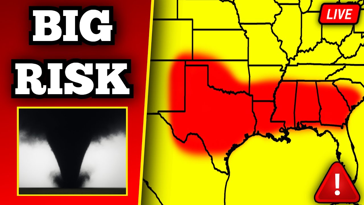
🔴 BREAKING Tornado Warning In Texas – Tornadoes Possible – With Live Storm Chasers
right in front of us. All righty. We are We are live. We got a tornado in progress. Literally, as we just went live, there is a tornado in progress near Manard, Texas. Right. Crossing crossing crossing. We are live with a tornado in progress right now going towards Mayard, Texas. There’s legitimately a tornado in progress near Maynard, Texas. Look at the motion on this thing. This could be a intense tornado right now going towards Maynard, Texas. That is a huge tornado that has just dropped. This is Freddy McKini just west of Menard. A tornado again in progress right now going towards Maynard, Texas. That happened quick. We had one again like 2 minutes ago before I went live. And there’s now a new one that looks stronger here just a second ago. Right there. That’s a tornado. Zoom in on that dude. It is still in progress. Pretty strong. Once again, Mayard, Texas, southeast of San Angelo. That’s a full-fledged tornado right there. Chad, how do we get down to it? About to go back to Menard and drop south. Once again, this is going towards Maynard, Texas. This tornado is about two miles to the west of Mayard. Going right to town right now. Non-condensed tornado moving right towards Maynard. Jeez. Ripped up those trees. Just did some damage to some trees. I don’t think any homes were hit, but it’s still on the ground. It looks like I got you guys. It is still going just beyond the trees here. He’s just got a little bull funnel on top of him. And match just went live. I did just go live. All right, I’m going to roll these. I did not mean to time the stream like that, but we literally just had a tornado drop. It’s still on the ground. It is still down. It is still a tornado in progress going towards Maynard, Texas. This is also producing baseballsized tail. It is just beyond the tree line there. There are more chasers that are going to have a view of this, I think, in a second. How’s she looking, Eli? Not fully condensed yet. Copy that. Still a non-condensed tornado, but it is still in progress. You’d still see it right there in the middle right of your screen. It is still down. It’s about a mile to the west right now of Maynard. Still down. Just a big dusty boy. That was a great tornado intercept there. trees were right behind him. Oh, it’s incredible. I think it’s still down. Couple like maybe I can’t tell if it’s still on the ground. Okay, so this what we’re looking on radar right now. Obviously, I haven’t really haven’t had a chance to go over radar. Uh we have a tornado in progress. I believe it is still down and on the ground right now coming up into Mayard, Texas. Once again, this is southeast of San Angelo. Uh we have a large tornado watch in place and this particular storm is riding an outflow boundary. So it’s going to be able to produce the threat of a tornado as it continues to track down to the southeast. Rotation overall is not super tight. We had a tightening a few minutes ago north of the four mile crossing and I think it’s now cycling to produce another tornado here uh in the next few minutes as it comes into the town of Maynard eventually going towards the 5m crossing and the 10m crossing eventually going towards Hex. So again, this is right now riding along our boundary and it should continue to produce the threat of a tornado as it moves to the eastsoutheast. Uh this is Connor who is looking at the wall cloud. He is currently on Highway 83 coming up into town right now. I don’t know if this is still on the ground, but it was obviously at the very beginning of this stream. Um that there’s still a bowl lowering there. And if there’s a tornado, it’s non-condensed. Trying to see where exactly that dust swirl actually is. Let me see if Let’s try tornado pa. They’re underneath it, I believe, as well. Oh, yeah. That is swirling right there. That is swirling. Swirling right above their head. So, I don’t think this on the ground anymore, but it is definitely still rapidly rotating right above their head. And again, if there’s a tornado, it’ll be coming into the town of Maynard, Texas here over the next few minutes. Their windshield’s broken. They’re half their cars broken. They they have their their back windshield broken out, too. And their Starlink is also broken from yesterday’s storm. So, I don’t know. By the way, baseball size tail is also coming up into the town of Mayard, Texas here over the next few minutes. in addition to a potential tornado. Yeah, it wasn’t like dusty surface. We got a large wall cloud right above their head right now. And we just had a storm merger come into the storm from the south. So, it may try to drop another tornado here. And I think it’s going to if we look at radar right now, this what it looks like. So, again, we had a little storm merger come out of the south. And so, that right there is going to help to intensify our circulation right along the outflow boundary. And the velocities are starting to pick up again. and starting to get a little bit of a tightening there just to the west of Maynard. So, this might be gearing up for another tornado here in the next couple minutes. It is still rotating quite a bit right over their head. Um, you again see that spin right there. It’s spinning a little bit. It should start to rotate more here over the next couple minutes. You watching elsewhere? Oh, what is that right there? What is that? Is that a tornado? Yep. I think that’s a tornado. Is that another one? was quick spin. Was that just dust? That might be dust from the last tornado. Or maybe another one just dropped briefly. It’s a lot of dust right there. Yeah, I think it still is back there. Yeah, I see swirling dust. Just very very needs a big gust of flow. There it goes. Bicycle. What are you doing? They are a lightning rod. Look at it. Conor’s coming up underneath this right now. Let me go to Connor. It’s not strong. Conor’s also got a dent to his windshield. They go back to tornado pa. They’re still underneath it again. This thing is still rotating quite a bit. Velocities have been intensifying again on radar. It’s on and off. Is that on the ground again or is it just might be trying to drop again? It keeps spinning. Nice little vortex. There’s one right there. They have issued a new mezoscale discussion outlining that this is really going to be probably the the storm that produces the greatest tornado and giant hail threat. Oh yeah, look at that wind blowing in there. A new tornado warning has been issued. I think that it’s hard to tell. It’s still spinning. Look at the radar. It’s right underneath our our little wall cloud here. So that could be a tornado. Either that or just like a little brief gust. But I’m leaning towards it probably just being another brief tornado. Here we have a new tornado warning also for Hattie or Lauderdale and as well as Clark counties in Mississippi. So this is what it looks like way back off to the west. We also have a line of storms rolling through uh Mississippi right now. Brand new tornado warning. That’s Meridian Stonewall uh just south of Marion. Seek shelter if you’re in this tornado warning away from windows and on the lowest floor possible. We got an entire line of thunderstorms here that is going to continue to produce damaging winds and embedded tornadoes in eastern Mississippi in addition to western uh Alabama. Also, I want to point out the bottom right camera. We’re going to go full screen to that here. Uh that is actually a Project Weather Eye camera on radar Omega. And you can see the inflow coming in from right to left right now, right in Manard. So, that is a lot of inflow that is pumping into this uh area of rotation. And it again, it might be trying to gear up for another tornado. It is still rotating uh quite a bit and has already produced one tornado and is seemingly producing brief tornadoes right now. Uh multiple little dusty areas of circulation right underneath our wall cloud here over the last few minutes. Man, this is live with Tornado Page, who’s also on YouTube. Freddy McKenny’s also on YouTube. He had the shot at the very beginning of the stream. They’re starting to drive again. Freddy’s also coming up on this. Let me go to Freddy. Freddy’s underneath this right here. I’m sorry, Eli. Do you forgive me? No. What happened? Too bad. I forgive you. A classic example of knowing how to read the sky instead of the radar. This is a better view of the wall cloud by the way from Connor’s POV. Right side of your screen. That’s the area of interest. Power out or something. I’m in the middle of middle of a town with SOS. For the record, this storm was not warned for a little bit of time here. Hopefully everybody in Menard is in their safe place. It it got warned a little bit late. It’s very short notice. Hopefully everybody in Manard, Texas is in their safe place again. This is still a radar indicated tornado warning. It was on the ground to start the stream. Yeah, good call. Um just trying to get a bearing. Oh, cyber truck. Gross. That’s what it looks like. Bottom right of your screen for the area of rotation. Yeah, still got an inflow pumping into the storm. Again, that’s the live shot on the project weathery camera. You can see the inflow. Look how fast it’s going from right to left. It’s all pumping into our messocyone which is rotating and also into our wall cloud. So it is absolutely pumping in right now. That’s clear. That’s clear. This is back to Freddy who just intercepted this tornado. Did I call it? Yeah, you had it. It’s It’s right We did it, Freddy. We did it. I know. We were the only ones there. I know. That was It was hucking trees, bro. It was like locked in trees. Ripping them out. Shut up. Yeah, that was when it happened. I know. Well, I flip around. I see the little Let’s go back to live radar again. This what it looks like on radar right now. We got a really classic looking hook echo on this storm. It is riding right along an outflow boundary. So, again, this is just another example of what we basically had yesterday back over north of Abene with an outflow boundary. It’s basically riding right along our outflow boundary with a hook echo and we clearly have a messocyone on this. Pretty strong rotation still in the low to mid levels and it may be gearing up again for another tornado. I think it’s going to drop another one here as it tracks towards Highway 29. Longterm it’s going towards Mason, Texas. Again, we have a large tornado watch and I do fully expect that we’ll continue to see a tornado threat here uh anywhere from even Austin and San Antonio and back off to the northwest with these supercells, especially the one here that is riding right along the outflow boundary. Still a pretty clear area of rotation right now near Manard in Texas. Uh let’s go back over to North Texas real quick. We just got a severe thunderstorm warning near Graham, Texas. That is for half-dollar size hail and 60 mph winds. That storm right now is tracking to the northeast going towards Jboro. No tornado threat on that storm. That is an elevated storm. And then back over in Mississippi, we have a tornado warning right now just to the south of Meridian. Pretty clear meone on this. Uh this could also produce a QLCS tornado, meaning a tornado embedded in a line of thunderstorms that is tracking in the direction of Cuba, Alabama, just to the south of York in Lisbon is also going to be in the track of this moving to the east northeast. We have a large severe thunderstorm watch in place here that goes until about 10:00 tonight. Uh that is mainly going to be for hail and as well as wind, but a low chance for a tornado. I think Connor has a lowering. Um he has low signal, but I think he has something spinning there. We’ll go back to him in a second. Let me see who else has this. Let’s go to tornado. Oh, let me actually go back to Connor. You just came back. You’d see it right there. It It’s rapidly rotating. Look how fast it’s rotating. Hopefully, it goes full screen to it. Look how fast that thing’s rotating in the middle of your screen. From the north side of it in a second. It is rapidly rotating right now near Manard. See how much it’s spinning right there. This thing might This thing might drop another tornado. Look at that clear slot. Look at that clear slot coming around. Literally looks like it’s going to drop a tornado again. My radar’s not working. So, I’m just going to get that off the screen. Look at that bowl. This thing’s rapidly rotating. You see the inflow coming in from the right right now. This is literally going to drop another tornado or probably will at least. The velocities are pretty strong over the town of Manard right now. If you’re in Manard, Texas, again, seek shelter. Is still rapidly rotating here. Can’t tell. I don’t see anything condensed in there still. I don’t see anything condensed in there. Once again, this is Connor Craw. He’s also live on YouTube and almost all of our chasers that we have are linked in the description. You can still see a rapidly rotating back in there. It’s starting to get a little rain wrapped. Freddy’s actually in the path of this. There might be a tornado right a condensed tornado right in front of us right there. It’s getting all Look, Echo still wrapping. It’s gotten a lot more rain wrapped over the last minute. Look how Look at that large rain shaft there now. Like if we have a tornado, it could literally be fully rain wrapped. That inflow just pumping from the right. Guys, I don’t even know if we’re still alive. This is an AT&T dead zone for some reason. Right next to this town. Very, very unfortunate. He is alive. So, I’m not sure if we have the We don’t have a CC drop yet. Waiting for velocities to update. Is still rapidly rotating here. I’m looking at all of our chasers. Currently, nobody has a clear view of a tornado, but I mean again, this could be a rain wrap tornado. Latest velocity scan a bit broader and give give a little peak. Waiting for it to come out and give us a little peak. There’s the There’s the Hey, Vex with the $10 super chat. Gatesville, Texas. Should be mainly a wind and hail threat tonight. low tornado risk. This storm has the best chance of producing a tornado in the long term. Again, this is literally riding along an outflow boundary. And generally speaking, right now, we have multiple uh we have this large like outflow boundary right here. So, the storm that’s going into San Angelo, for example, right now is mainly going to be hail and wind. Same thing with the other storm back off to the west. We do have a little boundary here. So, that could flirt with this storm and maybe produce a tornado threat at some point, but right now it’s mainly a hail and wind risk. Definitely the biggest concern though is this storm that is literally right along the alpha boundary. It’s been like this for well over an hour now. Uh one thing I’ll point out though, we got a lot of storms coming out of the south that are about to merge into this thing. And if that happens, that could actually limit the tornado threat at least briefly and then it could recycle this storm again just like it has here for the last, you know, 30 minutes or so. Obviously, we haven’t been live for 30 minutes, but generally speaking, this has been the process of what this storm’s been doing for a while. We’ve had these storm mergers coming out of the south, and essentially this storm’s moving southeast. So, it’s basically kind of fueling the storm, helping it to spin more as well. And so, that’s what we’re witnessing right now. And then after this storm merger happens, it could go, you know, crazy again as it continues to move down to the southeast. So, that is generally what we’re looking at right now. Let’s go back over to Freddy. Let’s listen to Freddy here. Actually, let’s go back. I’m going to stay here for a second. Freddy again is on the southeast side of this hook echo right now. Hey Sean from becoming a member. I think it will recycle. I I do think this is going to be a long track supercell. I mean it’s already been going for two hours. What up here? Apparently the dominator just went by. It’s back to Conor the clearing there. The storm’s also producing baseballized hail. Good viewings still. Some big hailstones are about to fall in Manard, Texas on top of there being a tornado just a few moments ago. Easy escape route with this too. still spinning back in there. And eventually this will go getting some weird mergers happening here. We’ll eventually go towards Mason, Texas. It’s getting a lot of mergers in a short amount of time. Definitely a conga line. I don’t think there’s as many chasers today as there were yesterday for the record in front of me, but we aren’t going to see it at the moment. Baseballsized hail is going to be coming into Mayard here over the next couple of minutes. There is a camera in downtown Mayard that I’m keeping an eye on. See if there’s any view of the the hail falling. Still see the inflow pumping in there. Waiting for the velocities update. Latest scan still showing some rotation coming up on Highway 83 now on the south side of Maynard. eventually going towards 10 mile crossing is looking very rain wrapped right now if we have a tornado still inflow going into the storm pretty clearly this back over to Freddy so Freddy is looking more into it right now from the the east so he’s a little bit further down to the south from where Connor is yeah likewise guys that was a pretty good dominating intercept there you become a member wrapping in Chad, we’re looking off to the northwest here. If you can see through the gray, he’s also for becoming a member. Once again, if you’re just tuning in, this is a tornado warning near Manard, Texas. We also have a tornado warning in Clark and Lauderdale counties in Mississippi. A potential tornado trying to be embedded in a line of storms back out there to the east. This storm in particular is a discrete supercell. And now we got a view of Freddy’s. See if I can hop out for a second here. Uh sir, it’s going more. It’s going back to the west here. So it’s right there. That’s it. It’s all rotating right there. That’s it right there. Still see the inflow pumping in from the right. Flip the car around. Large meocyone. Still very similar to what we saw yesterday. Thank you. Uh, all right. We have a new update. As of one minute ago, I’m going to go back to Freddy in a second, but as of 1 minute ago, we just had a tornado verified by a private radar site uh just to the south of Meridian. There was This is an urgent alert. A tornado is on the ground. Seek shelter immediately. Okay. Well, they have upgraded the tornado warning in Texas to observed. Um, even though that was a few that was like 10 minutes ago, unless it is on the ground again, but uh right now they have upgraded that to observed. Let me see. Does Freddy have something? Hold on just a second. You can see south of Meridian, Mississippi. That was where we just had a brief tornado moments ago. Rain curtains wrapping there going towards Cuba. Yeah, it doesn’t look like it now, but in Alabama a second ago. That looked pretty good. Yeah, I know. Everybody left. So, which means maybe we’ll find the tornado still rotating. I don’t think it’s on the ground even though it got upgrade to confirmed. I think it’s just delayed. The National Weather Service at least in I think it’s San Angela has been pretty slow to issue the warnings. I think that might just be a delayed upgrade, but I could be wrong. Obviously, if you are in Mayard, Texas, seek shelter. It’s a weather spotter confirmed tornado. No other details on top of that. Wait, funnel right there. Is that a funnel right there? It’s trying. It’s trying. Man, look at the rising motion there, too. Still trying. Come on. This literally reminds me of just Robert Lee last year. It’s right outside of town. Very similar. Velocity scan is a small little tightening there near 83. It’s going to be moving into the very southern part of this tornado warning. Really no town names here. Ranch Road 1773, south of Mayard, Texas. Right in front of us here though. Eli’s got it. See it spinning. He’s got a wall cloud here. Basically underneath the wall cloud. Connor is still in the same spot as he was before. He might just get punched by baseballsized tail here. Dive in if it starts. Wait to see what happens there. Got baseballsized tail right now falling in Mayard, Texas. That’s a funnel. Yeah, that’s that’s a funnel right there. It’s really trying to drop. Does this storm have more of a southern component to it? Should we go if we go to 83, we can go east on 1773 and then 1221 south? We’d be We’d have to do it like now though cuz we’re about a mile. We Yeah, we’d have to do it like now. Not there. You’re talking that 83. Yeah, I see the 83 there. We might go not Mayard probably. This is from Connor’s POV. He’s a little bit further back. You can see how low the clouds are from this angle, though. Can’t see anything anymore. And he’s almost in the baseballsized tail core. So, he’s going to be positioning. Let’s back over to live radar once again. Tornado was in progress a few minutes ago. Back over to the west of Manard. And now we’re looking at a little couplet here just to the south of Manard where there could be a tornado. But we really don’t know right now. Freddy’s been keeping a very close eye on it. It just looks like it’s a wall cloud right now that’s spinning um still pretty rapidly. And now this is the latest radar scan as a 420. It’s completely oluded by the looks of it. But again, we have storm mergers coming out of the south. And once these storm mergers are done, this supercell should intensify again, recycle, and produce yet again another tornado. So that’s basically what we’re keeping an eye on right now for the Menard area here and also just south Manard. So we’ll eventually go towards Mason, Texas. But there’s also, dude, there’s more. There’s more areas down here. Still see it. You can still see some spin even in other spots, too. A lot of little eddies kind of spinning around this storm. It’s right along the outflow boundary. So, we we can try it. It’s just going to be risky. What was that right there in the middle? Okay. That’s definitely coming down, though. That little bowl right there. Yep. That’s a bowl. Got a little bowl right there in the middle. Might be coming down again. The velocities are way broader, so I’d have to assume it’s not going to be south long if we had a tornado. Got to be careful. We got these not really going down that far. Thank you, Lisa, for coming. Remember really accelerate things in a weird way. All right, I want to go back to live radar. Let’s go back over to the east towards Mississippi. As I was mentioning, there was a tornado confirmed by a local radar site a few minutes ago southeast of Meridian. I do not think it’s on the ground anymore, but this is going to be moving into western Alabama here over the next few minutes going just to the north of Lisman and Butler and just south of York. So, if you’re in this general area, be ready to go to your safe place. Tornado potential going to be slightly higher as this storm continues to move east. Again, it is a large line of thunderstorms. It is a QLCS tornado threat. Basically, meaning we have tornadoes embedded in a line of thunderstorms. And that’s what we’re watching for right now as this moves into southwestern and as well as western Alabama here over the next hour. Montgomery just out the Tuscaloosa. You guys are included in a severe thunderstorm watch as of right now. There’s still something there to their left. It’s still spinning. Looks like their audio got a little bit glitchy. Let me try to think that’s just everywhere. A little bit of laggy audio. It should fix itself in a minute. back to them in a second. This back to live radar back over in San Angelo, Texas. We talked about this a moment ago, but if you’re in San Angelo, be ready for quarter to half dollar size tail and 60 mph winds. We actually have a little CC drop for hail right now just to the south of Tanker Slay coming up towards Burn and as well as Bentwood on the south side of San Angelo here over the next few minutes. Again, no imminent tornado risk with this storm. It should be mainly hail as it moves through San San Angelo, Texas. And then back off to the west, we have a little outflow boundary right here that could get interesting here soon. We got a few supercells that have fired up here south of Sterling City. Neither of these are rotating yet, but if either of them can latch to the outflow boundary, which would probably be this one. The tornado threat might start to increase a little bit as this continues to move east. So, that’s going to be something we need to keep an eye on as that continues to move eastsoutheast over the next few minutes. Also, let me go to this camera. This was downtown Manard, Texas. a few like this is live right now. This is one of the uh project weathery cameras and in fact we actually just had a report 3.25 in hail was reported on the west side of Manard. I can’t see any hail coming down right now but the hail core will be right over town. So I’m not seeing any hail that’s coming down right now but we just had a report moments ago on the west side of Manard, Texas of 3.25 in size hail. So this has actually been producing some really big hail here and it will likely continue to produce big hail as it continues to move east. The big thing that’s going to be uh kicking the storm for a little bit in terms of the tornado risk is all the storms that are coming out of the south. Once these storm mergers happen though, it should organize again and produce another tornado at some point as it moves towards Mason. So that’s what we’re going be watching for here over the next little bit. Thank you uh Dian for becoming a member. Welcome to the velocities. Is it Maynard or Menard? I thought it was Manard. But it was Menard, Texas. Let’s do put Matthew Kapuchi bottom left. Everybody’s positioning now, so we’ll give him a few minutes here. Manard, thank you. A new tornado warning has been issued. All right, new tornado warning. This one’s going to be for Manard in Kimell counties in Texas. Radar indicated rotation here. uh should pop up in a second. Again, just to the south of Menard. There’s aboutif I think that was about 2,000 people in the first warning. And so, this one’s going further down to the south. The storm’s again mostly going southsoutheast right now. This will be going towards Cleo and London, Texas. So, about 1,600 people are in this warning. If you are in this tornado warning, seek shelter, get away from windows, lowest floor possible, and get to an interior room of your home or building. Uh very interesting actually. We got a little rotation near 83. And we got another little area of rotation south of 29 now. So we got two little cells here. This has really been the main one that just produced the bigger tornado west of Menard. And now we got another area of rotation that’s developing just down to the south of 1773. So that is going to be something to keep an eye on. We actually got another area of rotation that is developing on a different little supercell that’s fired up in front of our outflow boundary. Uh so definitely another storm to keep an eye on, but it is a relatively large tornado warning. So if you’re in London, Saline, or in Cleo, Texas, seek shelter. There are four schools that are included in this tornado warning, which I believe school may still be in session. We’re in May, it’s May 26th right now. So, and also, if you missed it at the very beginning of the stream, this was back when we started this stream. This was when the tornado was on the ground at the very beginning of the stream. That was literally to start the stream in case you missed it. Possibly one of the crazier tornadoes we’ve started a stream with. I mean, this is a close-range intercept. It literally started on the road. So, this started the stream about 25 minutes ago. Mayard, Texas. It’s absolutely crazy that that thing dropped literally as we started the stream. I started the stream not even knowing there was a tornado on the ground. I literally just had him on. I I knew there was a tornado beforehand and that thing looked even crazier. There was like a brief tornado and then that one got a lot larger. It was like probably about a minute long, maybe two minutes long. Hey, take five golf for the $10 super chat. Alto, Texas. Not really looking at much aside from isolated hail and wind tonight. Tornado risk is pretty much zero up there. Again, we have a we have an outflow boundary down here to the south. We’re going to continue to see a lot of outflow boundaries over the next few hours. But notice that our tornado risk is mostly uh elevated here in our 5% tornado risk which is south of Brownwood near Kurville northwest of San Antonio. So generally speaking the greatest tornado threat will exist uh here in western and central Texas where we have outflow boundaries and also multiple discrete supercells. In addition to that we had a line of storms that went through a large chunk of Waco Colleen and also near Tyler, Texas this morning which has basically stabilized our atmosphere to some extent. It will destabilize here over the next few hours, but it’s going to limit our tornado threat. We’re not really expecting discrete supercells to fire off out here. You’re basically going to get the leftovers of what we have right now in West Texas. Uh back over to the north, these are all elevated storms, so we’re not talking about really any tornado risk, I think, for most of North Texas today. It should be mostly hail and wind. Uh back off to the east, we have a large 2% tornado risk in the Dixie Alley for mainly eastern Mississippi and also western Alabama. And again, we have one tornado warning right now, which again, this could drop a tornado at any time. Right now, the rotation’s gotten pretty rain wrapped. It’s just to the east of Meridian going towards Cuba in western uh Mississippi and then event or western Alabama, excuse me, and then eventually going towards Highway 80. So, we’ll continue to watch for mostly numerous damaging winds across this line and also a couple more embedded tornadoes as it eventually moves into western Alabama here over the next hour or two. Today’s risk of severe weather, by the way, is an enhanced risk of severe weather in Texas. So we do have a level three out of five enhanced risk of severe weather today. We also have a large slight risk near Odessa all the way back towards Montgomery and Alabama. And we also have a new slight risk of severe weather back up in western Oklahoma and also the Texas panhandle. Biggest concerns being damaging winds and also a little bit of hail. So again, all hazards of severe weather are on the table today. The biggest concerns in Texas are hail and wind, but there is a chance for a couple of tornadoes. And we’ve at least already had two different tornadoes. So hey JRod for the super chat. That is correct. That is correct. Luckily, that tornado I don’t think damaged much. It was mostly just trees. I don’t think it hit any homes. So, that’s that’s at least good news. The last few radar scans, we have a broad area of rotation where Freddy is right now, bottom middle of your screen. And then back off to the east of where Freddy is. Uh slightly stronger area of rotation that is currently tracking towards, I believe, London and Saline. So, again, we have to keep an eye on this. New tornado warning has been issued. We still have a confirmed tornado warning for Menard in Texas, but I think that one is probably going to be allowed to expire here soon. New tornado warning in Mississippi. This one’s going to be near Marion and Meridian. So, seek shelter if you’re in this warning, mainly to the northeast of Meridian. If you’re on the northeast side of town, I’d seek shelter here for the next few minutes for the damaging wind threat. Our main area of rotation is over the town of Marion, Mississippi, moving towards Tum Tumuba and then eventually moving towards Narquita. And then after that, it’ll be moving into western Alabama. They’ve already issued some severe warnings here for western Alabama for 60 mph winds and quarteriz hail. Uh Livingston, York, and the I2059 corridor here are in the track of that. Again, broad area of rotation, but could tighten up at any time. Could get a a quick little spin-up tornado really at any moment. Let’s go back over to Texas. Latest scan. This is definitely a hook echo. Keeping an eye on Vince. Vince is coming up on this. There is a pretty defined hook echo on this little cell here. Let me go back over to Freddy. He still has a looks like a wall cloud there. Action. He’s pulling in some mulch. Well, there’s at least a little bit of a view there. Yeah, I’m going to crawl into the back quick. By the way, I did talk to Freddy before the stream. They might go for I don’t know if we’re back or not. I don’t know if we’re back. They might go for three days in a row being almost whatever. I don’t know what’s happening. I don’t even know what’s happening anymore. But yeah, we’re in a good spot here. Good call to come south there, Brandon. Glory, intercept. They’re in the middle of the storm. Let me see. Wait and see if Vince comes back. Looks like Vince has a a wall cloud. Oh, we Why in the hell we don’t have LTE out here. That would be a better thing because signal Vince is coming up on the little discrete cell that has just developed to the southeast of Menard. Again, this is a brand new storm. Little mezo on it. There might be a lowering off to the right there. I thought I saw one briefly when I was looking at his camera off screen. So, that’s why that is. It’s way higher than I thought it was. Just waiting to see if All right. He’s panning the camera, I believe, to the right. Maybe the left. It’s not because I have lacking equipment. I put hundreds of thousands of dollars into this equipment over the past 10 years. Trust me, it’s seriously probably hundreds of thousand dollars after I burnt everything over 10 years. Like, it’s not this is not garbage. Might be something right there in the middle. Hey, Blue Ridge, for becoming a member. And it can only get so good, folks. It can only get so good. right there. But again, he he’s currently looking into the new cell that has begun to rotate. I don’t see anything very definitive. I mean, it definitely looks low back there. In the middle of nowhere, might be a wall. Question would be horizon. Why don’t you have spectrum out here? Because you should near 1773 Road. That is our main area of rotation right now is that little storm here that is formed out in front of our main supercell. Everything’s just kind of merging together right now. So, it’s going to take a few minutes for a definitive that supercell back off to the west to really ramp up. I think it’s going to take probably 10 15 minutes here. Breaks. What the Jesus? But at least for the time being, this is the more concerning storm. Yeah. So, looks like tornado pa is also coming up on it. So, you can see it doesn’t look like it’s anything too concerning yet. This is again right to the south of Hex, but this will be the next storm that we need to keep an eye on. We’ll keep Let’s see. I’m going to do that. Let’s do two. And then we’ll do three. Again, a lot of chasers have low signal right now. It should come back here shortly. Thank you, Rick, for becoming a member. Thank you, Allison, for becoming a maximum velocity member. Today is May 26th, by the way, and apparently looks like Freddy has a burrito intercept. Uh, today is May 26th of 2025, and a year ago today, if you guys don’t remember, we had a moderate risk of severe weather back over in the Ohio Valley. trying to find the little reports here. But literally a year ago today, we had a major tornado outbreak that happened with 74 tornado reports in addition to almost or actually over a thousand wind reports, making that one of the biggest severe weather outbreaks we had last year. So that is a year ago today on this day, which is actually kind of bonkers. I’m not going to lie. It’s crazy to think that was a year ago today. I’m trying to find the severe weather outlook. For some reason, I can’t find it. But it was the moderate risk of severe weather. All right, here’s tornado pagey. They definitely have a little mezocyclone here. So again, just southeast of Menard. I think that was one of the first days I watched. That was the first stream I think that maybe not the f it wasn’t the first ever tornado emergency that we covered, but it was one of the first that we’ve ever covered on a live stream was that was that day. I think we covered multiple before that, but that was like the sixth or seventh probably that I ever covered. On top of that, I think that was the first time we ever got over 20,000 people watching a stream at one given time. That was one of the more significant events. That was the tornado emergency in western Kentucky. I can’t remember what the tornado name or the tor what where the tornado hit, but it was in western Kentucky somewhere. Doesn’t look like it’s rapidly rotating right now. Just broad for the time being. just spinning. May 25th, a tornado hit Valley View, Texas. There were so many tornadoes in Texas last year. You know, it’s very interesting. Like storms like the one that we’re looking at right now were producing tornadoes. Almost every single storm that we had last year, like in this type of environment, were producing tornadoes. This year, for whatever reason, it’s felt like we’ve had a lot less tornadoes, at least out of storms like this. We’ve had a few, but last year just felt, I don’t know, last year was just crazy. We had so many tornadoes last year. I mean, 2024 was undoubtedly the one of the cra definitely the craziest year of tornadoes I’ve covered. Yeah, we have a new meoscale discussion from the Storm Prediction Center. This is going to be across uh Texas from Sterling City and San Angelo back towards New Brunfells and just to the west of Austin. Uh main concern here will be giant hail up to 4.25 in in diameter. Uh we had 6 in hail yesterday. So I mean I’m not ruling out something like you know that if one of these storms can stay discreet. 80 mile per hour damaging winds and there’s also potential for a couple of tornadoes here over the next few hours. The hatched area that we have here from Sterling back towards Fredericksburg is where the greatest hail and tornado threat is in the short term which will be within the next 2 hours or so. The storm’s definitely trying to cycle right now. Also velocities have upticked a little bit here. Uh near 1773 Road. We got a little bowl on the right side. This might be trying to drop another tornado here just off to the right. Got a little bowl coming down. Adding to it rippling. Yeah, maybe not. I don’t know. It’s somewhere on the right. Right middle. Could even be rain wrapped. Velocities on radar kind of correlate with that spot. So, possible tornado trying to drop just to the west of a west of Mason. Oh, yeah. That’s like interesting. Right here. Hey, I’m Melissa for the $20 super chat. Hi, Max and friends. Thanks for all you do to keep everyone safe. You’re amazing what you do. Watching from Virginia Beach. Appreciate you watching from Virginia Beach. Hopefully we don’t have to talk about your area for a while. Usually pretty quiet this time of the year. Thank you Ping King for the super chat. Colorado will be mainly an isolated hail risk today. Thank you Boo for becoming a member. Thank you take five for the other super chat. Also thank you uh Brian for the $20 super chat. Appreciate that. Happy Memorial Day everybody. Doing a lot of back building on the back side. Thank you also Edward for the super chat. Freddy’s coming up on this from the south. That is not Freddy. I don’t know which one’s Freddy. I think it’s I’m just going to put him on this one. Freddy’s coming out coming from the west up to this area of rotation which is basically just crossed over the road he’s on. It’ be on the left I think now. Maybe in the middle right now. Wow. Really nice wall cloud there guys. Like right in front of this thing, right? Yep. Excuse me. That’s a large wall cloud. Nice wall cloud right in front of us. Hey Bryce, for the super chat. Austin, Texas will be mainly a wind and hail threat tonight. Low tornado risk. Thank you, Chris, for the super chat as well. Appreciate that. Yeah, I wouldn’t shock me if we get a tornado just on this road here. We’re in like perfect position. Hey, Morgan, for the $10 super chat. I appreciate that. Wait, no, the road turns right here. Are you kidding me? No way. We get right up here and the road curves right. might have to just freaking Yeah, there’s still freaking still pretty clearly rotation on radar north of Saline. I would have been in the rain too much. Still very clearly rotation on this storm. And there’s clearly a wall cloud. Very, very nice. This is really the main storm right now. We have we have more storms to the west, but they’re all merging. So, it’s going to take a minute for really one dominant supercell to come together. No, I don’t know. There’s also another area of rotation attempting to develop east of 83. That is north of So, we got basically no clue. We got that large wall cloud there, but if you look at radar right now, we actually got a little area of convergence attempting to come together on a new supercell. And then this one’s just almost fully rain wrapped right now. It’s very, you can still clearly see the wall cloud on that, but it’s probably going to get pretty rain wrapped here in the next few minutes. So, pretty interesting what we’re looking at here. Let me do tornado pagey. Let’s see. They’re kind of underneath it. A little bit of spin right there in the middle. You see those CGs? It’s back over to Freddy. It’s very interesting. Oh, this is right next to the alpha is just too uh freaking Hey, Joe or John Johnny coming to me. Yeah, Greg coming to member. We’re on this couplet here just to our northwest. See where we’re at? See where the couplet is? Pretty pronounced couplet there. We’re at the drop down to 277, which is this road right here. And it looks like it’s starting to jog more east. So, we’ll probably come up here to the 277. See if we can intercept it there. Looks like Connor’s coming up on this now. Conor’s coming out from the north. Everybody’s coming from a different direction. I think Freddy came out of the west. I don’t know where to pa came from. Conor’s coming out of the north. I’m going to stay. So, you got the wall cloud right behind the trees there. Conor’s also live on YouTube. Link in the description. Have I gone stormchasing before? I have not, but I’m probably going to sometime this year. Let all those chasers go in front of me so I can make a quick U-turn if I have to. And this thing freaking plants and oludes right at me. Okay, look at that area rotation just off to my south. Late scan still showing rotation on radar. Still got a wall cloud off to the right here. clues. We’re We’re in trouble. Let me go back over to Freddy. Jeez. Freddy has a clear view of the wall clad, too. They’re on the left. Both Connor and Freddy are on this. Wait for Connor to get beyond the tree line there. Crazy motion in there or what? But clearly trying to do something there. We got more water just to the west of Mason. Also, Stormwater Media is coming out of the east. Everybody’s coming from a different direction on this on this rotation. It’s actually crazy. Everybody’s coming from a different place. They’re have to issue a new tornado warning because I mean this rotation’s literally going outside of the warning here in a minute. It’s going towards Mason, Texas. About to exit the east side of the tornado warning. Wait for this guy to go. I think Brandon wants to back up a little bit more here. Got CGs all around. Freddy and he is the lightning rod or lightning McQueen. One of the two. Something down. I don’t know what he’s pointing at, but I don’t see it. They pull up to him real quick. Freddy, that’s a wedge. Where? Right there. Is that really a wedge? The right edge is all the way down. That’s where all the RFDs around. Look at the edge. I I don’t Hold on. Let me Let me get a lock on it. I don’t think that’s a wedge. I’m going to hop out here for a second. Brandon thinks it’s a wedge. It’s impossible to tell the tree line, but gas is a star FD. I think it’d be to the dropped right in my eye. I’m watching everybody’s feeds, too. Not just Freddy’s. It’s a wedge. And I I don’t I don’t think it’s a wedge, but I think it’s just to our left, like to our northwest. I mean, this is It should be just to our northwest here. This is tornado pagey, by the way. Look how rapid that motion’s going in from right to left. Screaming it down that way. That’s just That’s a screaming inflow. I I don’t Yeah, I don’t think this is a wedge. But there could be a tornado. Waiting to see if we get a clear view from anybody. Guarantee you will. Just look how fast the motion is here. They did. Okay. Yeah, they did. Okay. just ripping into this. They’re they’re now in the RF now. Yeah, this just got a lot of lightning as we see, but it should be just to the left. I’m going to roll my window down. I got a view. Want to put them out? Yep. I’ll hold I’ll hold Chad. It’s right here. Rapidly rotating wall cloud here. She is trying to drop. Trying to drop here. Got a big RFD surge coming around. Look at this wall cloud rip. This wall cloud is ripping here. It’s literally screaming like the inflow everything west of Mason, Texas, southeast of Menard, Texas. Rapidly rotating wall cloud. This is Conor’s POV. Man, I I do not see a tornado, but it could be even rain wrapped right now. RFD sir. That’s not the tornado, by the way. Oh, wow. A new tornado warning has been issued. Brand new tornado warning for Mason, Texas. This is from Nard Kimble in Mason counties. Mainly for Mason, Texas. 1871 in the path of the bottom right of your screen. Yeah, it’s it’s just that’s what it looks like on radar. So again, Mason, Texas, you’re in the path of this. Rotation right now is near. We’ll have to keep an eye on down to the south, too, for more areas of circulation. This storm’s been rotating a ton in a lot of different areas, but uh generally speaking, again, our main area of rotation is getting a little bit more rain wrapped now coming up to Texas over the next few minutes and then eventually tracking towards Strereer and then Grit and then Mason. So again, seek shelter if you are in this tornado warning. Already has a pretty clear view of this storm, but again, it is getting a bit more rain wrapped. Wow. Rotation is just to the northeast of Salon coming up into cooking. All right, I guess I’ll go ahead. I don’t see a tornado though in progress, chat. I do not either. Do not see a tornado in progress here. Just strong RFD. That’s a big mezzo though for sure. I’m going to cook down to 377 I think. CG barrage is just going crazy right now. Bless you. Wow. Bless you. Thank you. There you go. I know. Thanks for the super chat also NF for becoming a member. That’s definitely a carved out messo Eli. Yeah, it is. I’m liking the look of it. Yep. That’s a nice carved out messo. This thing could drop a decent tornado. Definitely could. Starting to get into that RFD again. We got to cook down the 277 or 377. Wow. RFD. Beautiful shot here. I don’t think you sneeze from the rear flank downdraft. Beautiful shot. I still don’t see a tornado though. Just a rotating wall cloud. Hey, Elo from Kona member. Lots of sneezing going on. I’ve actually sneezed a lot recently, too. I think it’s allergies. It’s back over to live radar again. A bunch of chasers are on this right now. Our main area of rotation is crossing over 377 here in the next couple minutes and then eventually going towards Mason, Texas. I also want to give you guys an update back over in San Angelo. Look how fast our storm fell apart. We don’t even have a storm here anymore. So, San Angelo, uh, your storm has fizzled. It is currently not there anymore, but we got another one back off to the west that is right along an outflow boundary. And I wouldn’t rule out a tornado potential. A new tornado warning has been issued with this right here. All right, so we had a little area. This storm’s right along the outflow boundary. This one could also become a problem going towards San Angelo, Texas. So, be weather aware. Chance for a tornado does exist with that storm. It’s a low chance for right now. Brand new tornado warning in Alabama and Mississippi. This is north of Mobile and we got a large line of thunderstorms producing rotation. We got a new area of rotation that is currently tracking towards Bucka Ton Tuna southeast of Wsboro and then eventually going towards Miller Silos and eventually Coffeeville. So seek shelter if you’re in this tornado warning. It is radar indicated rotation moving to the northeast. Further to the north, we still have a tornado warning near Meridian. uh main rotation right now is going to be moving into Livingston, Alabama in a few minutes and they may issue a new tornado warning going towards Livingston and York. So again, this is a large line of thunderstorms that will continue to mainly produce damaging winds, but there is a chance once again for some embedded tornadoes as this moves into western Alabama. We’ll continue to keep an eye on it, but again, main concerns embedded tornadoes. They’ll be generally weaker. We also got some severe weather popping off now in New Mexico. Mainly hail and wind a little bit also starting to pop off north of Amarillo. Main concern for all these storms is hail and wind, but the tornado risk is not zero. It’s just very low up there in those areas. Back over to our tornado warning here in Texas. The again very clear area of a messyone. This where our strongest rotation currently resides. It is heading in the direction of Strereer and as well as uh uh Ksville and then eventually going towards Mason. And Freddy is currently punching through this. Keeping an eye on everybody. I’m going to go to let’s do Matthew Kapuchi bottom right. I might go full screen to him. This is Matthew Kapuchi’s view view right now. He’s on my radar. Also a meteorologist. He’s basically almost underneath this thing. Hey, Travis of the $10 super chat. There are a lot of chasers nowadays. There’s no doubt about that. At least the last couple days. Today hasn’t I don’t think it’s been as bad. There’s definitely a lot of chasers though, even out here. I think is right under this thing. Just a rotating wall cloud right now. Velocities aren’t tight, but they could tighten at some point. Just a very It’s very rain wrapped right now. We got a lot of convection that’s been popping off down to the south of this storm. So, a lot of storm mergers. Starting route to 132 Baron Street. Thank you. Head southeast on Ranch to Market Road. Sounds good. Back over to Freddy. Oh, you said you’re going. A new tornado warning has been issued. Heading norththeast. Got another tornado warning. Chakaw County, Alabama included in that one. Copy that. I haven’t quite made it to 377 yet. Quite a bit of wind picking up now where Freddy is. I thought you were right behind me. I was, but then I stopped there. I had a good view of the mezzo, so I just stopped and watched it before I got enveloped by the RFD. We’re up to five tornado warnings. We got yet again another tornado warning. This one in western Alabama near Butler. So, seek shelter if you’re in this tornado warning. I don’t really see a clear area of rotation. That right there probably just to the northwest of Gilberttown going towards Needam and Butler, Alabama. Seek shelter if you’re in this tornado warning. that is tracking to the northeast right now. So again, Butler seek shelter. We got now three tornado warnings. The one northeast of Meridian is starting to fall apart. Just a broad area of rotation. I don’t think they’re going to issue a new tornado warning into Alabama for this, but that could still produce a tornado at some point. It’s definitely spinning here going towards Livingston. Let’s go back to Freddy’s actually got a lot of wind picking up right now. It’s in the RFD up there just in case, but yeah, I’m ready. I’ll be ready to turn around if RFD is picking up. Latest radar scan showing still a broad area of rotation overn. That’s as of 3 minutes ago. We should have a new radar scan in a second. Continuing north a little bit. I’m going to keep going. I was about to turn around, but I’m starting to see it clear out. So, yeah, Freddy’s in the RFD. He’s going in the direction, I believe, of the area of rotation. Yeah, I’m just southwest. I’m going to So, he’s in the RFD right now. It’s blasting. RFD is going nuts, chat. Ridiculous. Thank you Jenny for the $20 super chat. Really appreciate that. Thank you Joey for the super chat. Ridiculous RFB here. Ridiculous RFD here. So some crazy RF. Why is that guy stopping? This is weird. That is sketchy. Maybe put on your hazards. Well, yeah. Maybe pull off the road if you’re going to stop. Yeah. Say you literally just stopped in the road. Wow. This is some strong RFD. really really strong RFD in here guys. Actually honestly I think our only option to stay on 377 till it runs into whatever that east road is 82 or 29 and then it runs this RFD is ripping velocities do not do it justice how strong the winds are here and they’re pretty consistent. I mean again he’s on the southwest side of the couplet. Just bad bad RFD. No idea where that is. Really bad RFD here, guys. It’s cooking. RFD is the flame downdraft. It’s all the winds that are pushing out from our our storm. Yeah, it’s directly in front of me right now. I’ve got it. All right. Yeah, this RFD is nuts. Easiest way to explain it. Slicing through. We’re going to be up on this thing here in a second. Slicing through the RFD here. So, we basically have an RFD surge, which is what we’re looking at right now. Again, that’s coming from our supercell. And then we have an inflow, which is the strong winds that are going into the storm. So, if we look at radar right now, you can actually see that pretty clearly. This all right here is just RFD surging. That’s where Freddy is. So, he’s in the middle of it. And then all this is basically inflow coming into our storm. So, that’s how we get all the circulation or messy. And eventually, Is there a tornado? Holy crap. I think there’s a tornado. It’s above the surface. Is that a tornado or is that just RFD? This road is getting real rough. What is going on here? Here is road. Road is a strong word. What this is? The winds are super strong. That looked like a tornado for a second. I think that’s just RFD again. It’s a path. Yeah, that looks like RFD. That actually scared me for a second. I thought there was a tornado. Velocities are really gearing up right now. Look, the scan is showing it even a little bit stronger. Oh, wait. That’s switching hard. There’s some This is intense RFD. They’re in a sketchy spot. They’re in between a bunch of trees and on a really weird road. All right, just cross the road. This tornado page also on YouTube. So, what were we thinking on 377? Well, we’re probably going to have to It looks like this is going to be our dominant supercell for a while. A lot of the storm mergers have ended. That’s what it looks like on live radar right now. We have had a lot of storm mergers from the southwest and I do think that this right here is now our dominant supercell. The initial dominant supercell has basically stalled over Manard. That’s where we had our initial tornado. Uh now we have a very clear messy just to the southeast of Menard going towards Mason. This is likely going to be our dominant storm here for quite some time as that continues to move east northeast. We go back over to Freddy. This might be the circulation here. Yeah, it’s off to it would be off to their right. So, they’re looking at the area of circulation. Oh, feel like this this might be a circulation here. Maybe kind of a little lowering off to my right. Yeah, this might be stupid hail court’s coming right at us. But here’s the uh just want to be careful here that there’s no report from another chaser, Ethan Morty. He’s saying there’s very intense RF in London, Texas. Debris thrown across the road. I’d keep them up here for now because I think the couplet’s very big. And it’s not just Yeah, I don’t know. I might flip back south here a little bit. This is a little sketch. It’s a little sketch here. This is far east of San Angelo going towards Mason, Texas right now. Got a ton of stormchasers on this storm. And again, the velocities have been ramping up. This thing may be gearing up for another tornado as it approaches the outflow boundary. Again, we are starting to get a more clean inflow and a hook echo and a big hail core as well. So, this thing is definitely gearing up likely for another tornado at some point here in the near future as it comes up towards Mason. It is a large area of different supercells and updrafts that have all gone up. And we also have a storm back off to the west of San Angelo that is predominantly producing half-dollar sized hail and 60 mph winds that could also become a concern for a tornado at some point. We have three tornado warnings also along the Alabama and Mississippi border. um all of which are broadly rotating. We don’t have a whole lot of rotation on the one near Wesboro. It’s pretty broad going towards Milry in southwestern Alabama. And we still have a tornado warning northeast of Meridian, but I think this one will probably be cancelceled. The rotation’s been a lot broader. And then the one near Butler, I’m also not seeing much rotation. I think the biggest concern right now for western Alabama and eastern Mississippi will be damaging winds, but embedded tornadoes will remain possible. Severe thunderstorm watch again goes for five more hours until 11:00 Eastern time, 10:00 Central time. The tornado warning here was upgraded for hail. It’s now up to tennis balls sized hail. Wow, Freddy is getting Whoa. Here, chat. That is even stronger than before. The RFD is just insane on this storm. This is near 377. There are a lot of branches down by the way behind where they where he is. Conor’s behind them. And there’s a lot of branches down. I don’t know how far you are behind me right now, Freddy. Intense winds here. Yeah, there’s no me getting east. I’m in like 80 90 right now. Car is shaking, bro. I flip a little bit back out. At least from my perspective, these poles are getting ready to topple. These poles are getting ready to topple right here. These poles are bending. Yep. Yep. Yep. Watch the poles. Wow. I mean, this this is hurricane force wind. The structure kind of looks outflowy, dude. You cannot see. Yeah, I’m in good 80 90 mile. I mean, this is pretty nuts here. Car is shaking like a boat. Shaking like a boat on sea. Jeez. This is easily hurricane force winds. There’s no doubt about that. Like I’m 90% sure it’s all just RFD cuz look at our radar. Clearly we’re just in the RFD. But just in case there’s something in here that we can’t see. Just want to be a little careful with it. Now I need to be point this way. See these are just the lightning. He’s a lightning rod for a reason. I’m not stepping out today, chat. Nope. We also have a vol on the eastern side of the storm. No tornado visibly, but there is a wall cloud. Oh my gosh, dude. This freaking wind. This is endless. It’s crazy. Just getting rocked. Absolutely rocked. Keeping an eye on those poles. On the what? The poles. Yeah, they’re they’re holding strong. ECGs are literally They look a little bent. I don’t know if it’s just the way it’s supposed to look, but they kind of look a little bent trying to get us. Hey, there’s something in the road there. Is there? Yep. Oh, yeah. Tree debris in the road. Yeah, there’s a little branch or something right there. Definitely some debris. Oh my gosh. Had a few reports of that now. Dude, tree debris in the road. Golet’s pretty close again. Oh, here comes some hail. The storm is producing tennis ball sized hail. I’m not sure if he’s a fan of getting tennis balls hit on hit onto his car. I mean, he’s done this plenty of times, but a little bit down here. Wow. It is still ripping. Wow. Wow. Wow. This wind is going insane. Once again, if you don’t know what RFD is, this is not real freaky danger. It is the It’s a rear flank downdraft from our storm. Basically, tons of downburst winds coming from our supercell. And uh this is again on the south side of our rotation. Just read real real freaky danger in the chat. That’s not what that means. Player here should be totally good. It’s just with how big the mezzo is. Hey Eric, for the super chat. This is just like literally impossible to chase. Literally literally impossible. I mean, we could drive in there, but that’s not going to be good at this point. If he drives into it, he’s going to drive into a hail, too. In addition to how high the winds are. It’s crazy. He’s been in the same spot for like just kind of ride it out. In the same spot for like I think six or seven minutes and is still ripping. We’re not too close. RD just keeps ripping here. And the hail core has gotten huge off to his north. We got a big hail core now and a scatter spike. Hail core. Oh yeah, here comes the hailore. You can see it on his radar here too. And that’s going towards Mason right now. huge hail core. It would have been like just barely to his north. It’s tennis balls at least, maybe baseballs. That would not have been good for the old ravioli here. No. So again, this this storm is obviously packing a punch and is actively producing the threat again of a tornado in addition to huge hail. Got a very clear clear slot now and an inflow. And again, this is your hook echo in addition to the rear flank downdraft. All the winds pushing out. And then here’s your inflow. And again, if we had a tornado, it’ be located right in here somewhere. We don’t have a tornado as of right now, but uh it may become torn out again here soon as it goes in the direction of Mason. Uh also going towards 87 northwest of Fredericksburg. But yeah, this storm is again pretty crazy. I This is typical Texas during the spring. This I feel like this happens very often. Freddy needs to make another U-turn. He’s still getting hit by high winds. It’s It’s literally non-stop. This isn’t a replay. This is still live. I’m going to go ahead and just bail. I don’t blame him. Going out all the windows right now. Uhuh. Yeah, I got hail falling now, too. I don’t think it’s worth it right now. This is insane. It’s been going for straight up like almost 10 minutes. This is nuts. Absolutely insane. Getting bigger for sure. So, and we’re not even to the main part of the core, which concerns me. When you have wind this strong and then you throw in like tennis balls or anything bigger. Yeah, that’s that’s not good. Barely even freaking see the road in ever drive through a super like this and thank Jasper for becoming a member. I mean, he turned around. He’s still getting pelted by hail and high winds. It’s non-stop. The weather’s a little nicer there than it is here. The weather’s nicer just about anywhere other than here right now. Yeah. It’s just not It’s just not worth freaking uh blowing out every single window in the car to go in there for what would be the most rain wrapped tornado in history. If even if there is one, I don’t even know if there’s one in there. I missed saying Zachary, welcome to the Storm Society. And Apple Z, welcome to the Storm Society. Welcome in, guys. Welcome in. I wouldn’t be surprised if we had hail larger than 4 in in the core of this thing. Again, the velocities are pretty crazy right now, but like the hail core has grown immensely over the last few minutes in addition to a huge uptick of lightning. We’ve had a boatload of lightning to the west of Mason. So, if you’re in Mason, Texas, definitely take this storm seriously. If you couldn’t tell, this storm is obviously crazy and has a mind of its own. It’s producing very high winds in addition to some huge hail right now. We’ve already had reports from earlier back over Menard, Texas of at least 3 in hail. 3.25 in was the report. On top of that, we’ve also had a 73 mph wind gust back up there to the west. I wouldn’t be surprised if this is 90 plus mileph winds right now in the RFD. The wind is still very strong where he is. It isn’t as strong as before, but it’s again it’s picking up again even even in the RFD a bit further down to the south of where our rotation is. Get through there. Just crazy. Absolutely crazy. How did my phone get water in the port when it never got unplugged? A cookie from being a member. USBC water liquid detected. Like, dude, how you were plugged in the whole time? Your phone got what? How did water get through? All right, while that’s happening, I do want to go back over to something that I was talking about a few about 20 minutes ago. Uh, for those that are wondering, today is the one-year anniversary of our moderate risk on May 26th of 2024. We had one tornado emergency that day, at least one. I think there was actually four different ones. It’s all in the same storm, though. But that was our moderate risk of severe weather a year ago today. Uh today obviously very different. Every year is different on every given day. It’s hardly ever the same. Uh but we obviously have an enhanced risk of severe weather today. This is the outlook for today. Again, we have an enhanced risk in Texas and then we have a slight risk that goes back through southwestern Alabama where we have a line of storms with, I believe, one tornado warning now and then another slight risk back over Oklahoma, Texas, and New Mexico. So for those wondering, is every year the same on every day? It is not. Very different weather pattern this time around this year. So again, we got a bunch of stormchasers including Tornado Paigy who is located right about here. You got Freddy McKenna and then Connor Croft all in different spots. And then Storm Runner Media right here that we’re keeping an eye on as well. So chasers are on all different spots right now. I’m actually going to pull up. Let’s do StormRunner Media. I’m going to put them bottom left. They got a pretty crazy shot of the storm coming in. We’ll put them bottom left. Uh they’re coming in from the east. So chasers are surrounding the storm. Absolutely nobody is currently in the hail core, which I do not blame them for. That hail core is huge. This is almost undoubtedly producing three to four inch size hail coming towards Mason. So we might see tornado page going into it. I highly doubt it though. I I would be really surprised push out ahead of it. All right, they’re starting to get out of the highest of the winds. You can still see it’s pretty gusty even a few miles to the southwest of that out ahead of this thing and uh of that area of rotation. This is Stormrunner Media coming in from the east and you can see how low the clouds are off there to the left. The wall clouds off to the left there. A little bit off screen now, but it is very ominous. Well, if it’s a big tornado, her road could be blocked, too. We got to think about that. Storm looks crazy on radar. This is a classic springtime storm in central and southwestern Texas that could gear up for a big tornado. It’s able to ride the outflow. Pretty sketch there. Back to them in a second. They’re losing connection, but I mean again, massive hail right now falling. We got a a likely 3 plus inch sized hail core there. It’s warning for tennis balls, but there’s no way it’s tennis balls. It has to be way larger than that. On top of that, we got a rotating mezocyclone and a definitely a wall cloud here north of 1871. If this thing can latch to the boundary, it could produce another tornado coming up on 1871 road here over the next few minutes. And then Mason’s in the track of a huge hail core. Uh, okay. So, both tornado warnings actually are in Texas. We have none right now in Alabama or Mississippi. They’ve canceled all the warnings, but we’re continuing to watch for damaging winds and a low tornado risk in Alabama over the next few hours. Again, we’ll keep an eye on that in case anything does pop off out there to the uh to the east of all of our other activity. Also, back over near San Angelo, we have a supercell that is coming up towards St. Angelo over the next few minutes, mainly with hail and wind, possibly a little bit of rotation north of 853 Road. So, heads up if you’re in San Angelo. I’d say the tornado threat is low right now, but it is right along that outflow boundary. So, if it can ride it, it’s going to be in an unstable environment with a lot of wind shear. So, I’ll have to keep an eye on that. That is a huge wall cloud. It’s a nasty storm, man. That is really a nasty. It’s one of the stronger cells I think I’ve seen in a while. We actually had 5 in size hail. 5.9 in size hail back over in Manard earlier. We just got a report back over in Manard, Texas. upwards of 5.9 in size hail according to a stormchaser with photos on social media. I have no clue who posted that. If anybody finds those photos, add me on Twitter or Facebook velocitywx. That is insane. If we can find that photo, I’ll try to show it. But 5.9 in size tail in Menard. Not like literally moments ago. That’s coconut sized tail by the way. I believe that’s that’s right about coconut sized ale. It’s like a small coconut. That is just insane. We had we had 6 in size tail yesterday, too. Absolutely bonkers. Thank you, Eric, for the gifted membership. Also, thank you Amber for becoming a member and as well as Shelly or Shelly for becoming a member. Shout out to Susan also for the PayPal donation. I appreciate that. Thank you diligent for the super chat. Max is the only Floridaian without a tan. Yeah, I mean I don’t touch grass. I don’t really have time to do that right now. We have a lot of crazy weather stuff happening. Look at this mess, by the way. This thing is crazy. If we get a tornado, it’s going to be large. It’s almost undoubtedly going to be a large tornado. It doesn’t It’s not like This is all inflow right here. So, this is still not really like tight rotation. It’s just a broad mezzo right now. If it can get back to the outflow boundary, this will probably produce a pretty big tornado. Storm runner’s coming up on it right now. It’s a huge wall cloud. Blue tinge back in there, too. Absolutely nasty, dude. That is so nasty, Garrett. This is I bet this thing has those 4 inch hailstones probably. So, we got to be very careful. Look at these inflow bands on it, too. I’m shocked it hasn’t produced. Well, it did. Well, like something big, though. That’s what I mean. Oh. Do we have a clearing anywhere at all? Garrett. Um I mean, once we get south, yes. But right where we have to go south is right where this hook is at. Can we beat it? Yeah, they’re driving into the hook right now. We’ll see if we have a clear view here in a second. It’s right here in front of us. So, it’s right in front of them. They’re on 1871 Road again, just southwest of Mason. That’s it right there. Golly, this thing is nasty. We’re in perfect position. Wow. It’s a huge wall cloud. Hey, Brad, for becoming a member, dude. It’s shrine, man. Dude, it’s going to be Look at how green it is in here. Oh my gosh. Really large blue tinge. This is our only tornado warning now. Just southwest of Mason. I don’t know. It’s rain wrapped back there. I thought we might have a visual, but it looks rain wrapped. I don’t see it. New scan. It hasn’t moved. Do it to our hail core. There could be some contamination with our inflow. But but it’s it hasn’t like tightened up, but this is definitely the spot you want to sit right up here. Um, our road is literally right here to go south. Oh, well, we do have a south. That’s what I’m saying. This this road, this is the south road that that that’s really close. South road. Oh, I see. Oh, it’s a little bit further up actually. What causes the blue? The blue is caused by basically water droplets being reflected back mainly from the sun. Road or it is from the sun. It’s not mainly from the sun. It is from the sun, but it’s basically just scattering of water droplets within our cloud from our sunlight. It’s usually later in the day, like now, like it’s 5:16 p.m. It’s usually later in the day when we have our sun angle off to the west. And we’re looking we’re looking west right now into the storm. So that’s why we have that blue effect. Really can’t see this in other spots of the storm. If you’re looking from the south, you really won’t see it onto the intersection of our road. Want me to go to the intersection of these this road south? Is that what is that? No. Storm’s eventually going towards Fredericksburg, Texas. It’s still about an hour out or so, but Fredericksburg definitely a heads up. Early heads up here you’re back down there. Mason’s really the main city in the path of this with probably over 4 in size tail falling west of Mason. Okay. Yeah. Okay. So, I’m going to go south on that road. Okay. Yep. We’ll book it out in front of it and hope if we can ever see it, man. You Okay, hold on. That might be a I think we mile. We’re a mile from it. Okay, we should be able to largely beat it because then if we decided to if we decided to turn around right now we’re out to get big RFD. Oh yeah. Oh dude, there’s like a big circulation on on velocity. Well, this is your choice if you want to take it. You can you can turn around if you want. No, no, this is an obvious tank cuz we got to stay This is obvious, man. This is what we got to Okay, keep your eyes out if there anything in the rain. Okay. Okay. Just keep your eyes out to the right. It should be right in there somewhere. Keep your eyes out. highest people. See the rotating rain curtains right here? Want to see? They’re about to drive into the RFD. They’re literally about to drive into the RFD here. They’re in a tough spot. I don’t know if they’re going to make the other road that they beat the trying to go to. Thank you, Jen, for the five memberships. Thank you, Brad, for being a member. If there’s a tornado, it’s going to be fully rain wrapped. That’s it. So, let’s do it. That’s your decision on that. 100%. No, I know. I know. But I don’t see any other options. Garrett, do you? No. Hopefully, it doesn’t get too bad. Connor is now in the RFD search, too. This is Connor. Whoa. Yeah. Here comes the RFD. So, he’s in the RFD surge right now. Make it cleaner so we don’t have the radar on here. We’re pretty close to this thing. Hey, Justin for the super chat. Georgia will be an isolated damaging wind threat. Jeez. Holy crap. This is just hurricane force winds. Yeah, it’s okay. We’re in an okay spot still. Really just hurricane force winds blasting here. This is insane though. It’s 1871. This is probably 80 mph RFD, gust of 80. This is This is ripping the car here. Are we sure this this just isn’t a a hurricane? I don’t think this is a hurricane, but I mean, it basically is one. Theoretically, it’s a hurricane. It I I don’t think we have a tornado yet. It’s just it’s insane how strong the RFD is. This is just ripping the car. Oh my gosh. It’s going to freaking This is going to like roll me. I’m going to have to face the wind here in a second. Going to have to face the wind in a second. I don’t think it’s a hurricane. It’s not hurricane season. You can still get hurricanes before and after hurricane season. Here it comes. This is just crazy. This is literally I mean this is like 3 minutes at least now. I mean, Freddy was in it for like probably 10 minutes. So, when you think about it, this probably going to keep going for another like six or seven minutes. He’s not even in the highest winds, by the way. He’s still like a mile west of the highest winds. Just in the outskirts of the RFP. It’s crazy. It’s probably over 90 in the actual rear flank downdraft surge near 1871 Road. Insane. Holy people driving that way. How do they even get through that? That’s crazy. What are these people doing? Oh, wait. They turned around. Those are people in front of us. They said, “Nah, we good. 60,000 foot echo tops. Is that accurate? Yeah, this is probably I mean I haven’t looked at the echo tops at all today, but this is this is there’s no doubt this is around 60,000 ft tall. There could be a tornado down on the road in front of us, especially with the hail core and everything. I have no doubt that this is over 60,000 ft tall. There’s a nice couplet on the radar down by San Antonio. This is insane. I’m watching Storm Under Media, too. They’re actually in the hook, Echo. I I haven’t seen them see any huge uptick of wind yet, but they’re in the hook. Get him. It literally It literally be down the road. You see me from becoming a member. I’m going to keep on Connor for a second. I’ll be back in 60 seconds. Crossing the road up here. I mean, these these winds are consistently 60 with gusts over 80, I’d say. Especially like some of the ones really start rocking the car. Some of them really start rocking the car. Barbara, they have a super chat. All right. By the way, we got I’m going to show you guys the five inch or 6 inch size tail that just happened in a second. Velocities have upticked over the latest scan right over where Stormer Media is, but they have no connection right now. It is still very windy in this RFD. But Connor bottom right of your screen. This is the uh 5.9 in hill. I fell in uh Manard, Texas about an hour ago or so. This is literally bagged because it’s going to be used for research. But that is the 5.9 in size hill which again is the size of a coconut or small coconut at least. It’s somewhere in that vicinity. Again, this is from Landon Meller on Twitter. But again, that is just massive hail. So yeah, that could literally I’m not even kidding. That could literally kill somebody that like that’s huge hail. So yeah, latest scan on this storm showing pretty strong rotation right now right over 1871 road. Uh again, definitely a concerning storm. Still got a hook echo. Very big hail core as well off to the west of Mason. And we are continuing to watch for as large as baseball, maybe even up to 4 in hail with this storm as it continues to track to the eastsoutheast. This is back over to Connor. I’m going to see Ryan Sch might have a view of this right now. can find where his location is. Conor’s driving right into this thing right now. know where Ryan should, but he doesn’t really view the storm. Stormer Media We’re only in 40. Storm Media is in the hook gecko right now. I’m surprised they don’t have stronger winds unless their location just isn’t updating. They’re like in the middle of it, but I don’t think they are. I don’t think they’re location updated. One thing I hate about this car wipers, the fastest uh they don’t know that. This is an emergency alert. A large and strong tornado is on the ground. Seek shelter immediately. What just got upgraded. It is a particularly dangerous situation. We have a large and extremely dangerous tornado in progress. It is radar indicated I believe in Texas. This is to the southwest of Mason. So again, this is a large and extremely dangerous tornado. It is a particularly dangerous situation. It is radar indicated. So again, this I guess the the velocities must reach the threshold for a PDS tornado warning. Even though we’ve not visibly seen a tornado, if we have one, it is definitely rain wrapped. Uh so seek shelter if you’re in this warning. Connor is right now punching into really high winds once again on the west side of where this tornado would be. Again, just got upgraded to a large a PDS tornado warning. That means particularly dangerous situation for Mason, uh, Texas, and the entire county almost. So, a large and extremely dangerous tornadoes in progress. Wow. And the tornado will be in front of him somewhere. It It’s likely a rain wrap tornado. Yes. Wow. I mean, I don’t even think I’m not even sure if there’s actually a whoa actually one consolidated tornado on the ground, but these winds are insane. All right, this is literally a full-blown hurricane that’s moving through this thing. Holy crap, chat. Hang on, guys. If there’s a tornado, going to be near 1871 Road about 5 miles to the southwest of Mason. This is just insane. It’s just going to be it’s just going to be a huge broad circulation. Probably multiple tornadoes down. Can’t even see. We reached the V-ROT threshold for a PDS tornado warning, which again is the reason why this has been upgraded to PDS. It’s radar indicated. We don’t have anything confirmed, but obviously you can see how high the winds are. Uh if there’s a tornado, it will be large. I mean, there’s no doubt about that. So, would he even see it coming? I mean, he’s on the west side of the RFD, so he’s not he’s not really in a dangerous spot, per se, right now, but um you know, he if there’s a tornado, be out in front of him by a few miles. Riley is on vacation. He’s not here. He’s going to be back on Friday. I got hail wrapping around now. My goodness. The winds are even stronger now. It just keeps going. Got hail wrapping around this thing a little bit. Once again, this is a large and extremely dangerous tornado or likely one at least right now heading in the direction of Mason, Texas and Route 87. Closer in a second. I’m guessing I’m guessing Conor is going to creep up further here in the next few minutes. Any tornadoes probably right tornadoes probably right here. I I would have to guess the winds in this are around 80 to 100 miles per hour just in the rear flank down. New circulation on the back side. It tightens up. So we are not safe to go yet. Hey Brooke for the super chat. Might have to bail east. Might have to bail west in a minute. This is our PDS tornado warning by the way. It includes a population of about 3,000 people. Headedwigs Hill, Loyal Valley, ArtMason. Great. You’re all included in this. Goes until 6:15 p.m. Central time. And this a life-threatening situation, especially with how high the winds are right now in addition to there potentially being a large tornado. Uh it would be fully it would almost be fully rain wrapped right now. All right, so this is a very dangerous situation here currently near 1871 roadway. This would likely be the tornado, but again, there is a lot of hail contamination, so it’s definitely hard to tell whether that right there is a tornado. Uh, Storm Runner Media, I think their location is just not updating. I highly doubt they’re still there because they’ve been driving this entire time. So, their location, I think, just bugged uh because of, you know, all the connectivity issues and stuff like that. Connor is definitely right here, though. And again, he’s still about 3 mi to the west of this tornado. And the fact that we are seeing this high of winds indicates that this is obviously a very intense storm. So, uh, there’s really no doubt about this storm being very intense. Freddy’s also a bit further down to the south. We’re keeping an eye on him. Uh, again, extremely dangerous situation though, assuming that we have a tornado right now. It would almost undoubtedly be a big tornado and probably very strong as well. So, this is back over to Connor. I’m guessing he’s going to start go for it, but I just don’t want to I don’t want a circulation to carousel around the main meadow. I know for a fact that I’ll have time to move right now if it does that. If I go if I go further, then I I might not have time. You should be on the lowest floor possible, though. If you’re in the tornado warning, away from windows, storm shelter, basement closet, or bathroom, if you are in a mobile home or a trailer home, you need to get to a sturdy structure. And it looks like Connor’s losing connection. He just came back. We’ll have another radar scan here in a second, but again, just look at this hook echo. Look at the inflow ripping into this storm as well. It is such a thin little inflow right there. And then this is Freddy looking into the storm as well. Yeah, back over there is where we’re watching. Give you a good front wall. Yeah, looks like we’re starting to link up with some more chaser convergence here. Starting to find the other the other chasers out here. So, he’s coming in from the south right now. We’ll keep an eye on him. Latest velocity scan showing our strongest area of rotation now just to the south of 1871 roadway. Again, this is currently tracking to the southeast. It’ll likely continue to go southeast, but again, there could be some deviant motion. It could definitely change directions here. Could become a drunk NATO, too. That has happened quite often here with some of these storms. We do not have a CC drop anywhere. All of this is hail. That is all hail that is falling all around uh the Cooksville area and also just off to the southwest of Mason. So, that’s not that’s not a tornado. That is just giant hail that is falling here in a pretty large area near 87. And so again, that is tracking right now to the eastsoutheast. Uh back over in San Angelo, we actually have a storm now moving into downtown San Angelo right now with mainly hail. It is up to golf ball sized hail now moving into the city of San Angelo, Texas in addition to the potential for 60 mph winds. This right here is not a hook echo. Our outflow boundary is further to the east. It is it looks pretty outflow dominant for the time being. uh low tornado potential if it can catch up to the outflow boundary, but for right now it is still pretty far behind it. So, greatest concern right now is this storm which has been latching to that outflow this entire time. Let me see if there’s another radar site that has a view. We’re starting to get to a radar hole, so it’s going to be a little bit harder to see this, but it still looks like all the radar sites are green that our strongest area of rotation is in this very large hook echo, which is approximately about 3 miles in diameter. So, it’s pretty large for a hook echo. It’s going to be a very large rain wrap tornado presumably. And Connor is sitting in his spot right now, but he’s going to start driving. So going to start driving towards the circulation. He’s been waiting it off mainly because how strong the RFD has been. That’s another problem. We’re good though. How fast is the tornado? If you’re talking about the speed of how fast a tornado is going to be moving, it would probably be in the ballpark of about 20 to 25 mph. But the the wind speeds of the tornado, I mean, it could easily be an intense tornado. There’s no doubt about that. It just we don’t really know for sure. We haven’t had a clear view of the tornado either. It’s likely rain wrapped. About seven or eight miles to the southwest of Mason right now, but again, it could go any direction. This is a view from the outside of the storm as well from Freddy McKenna. Supercell looks like from the south side. Also, this is like almost like a safari out here. The terrain is pretty pretty wild. Pretty wild terrain here. It’s a safari, guys. Yeah, that right there is the entire mess of cyclone back on on the left side there. I don’t even know. going slow. So, everybody’s all bottled up behind them right now. Shannon Williams with a member for five months. Let me go back to go back to Storm Runner. Storm Runner Media’s kind of in the middle of this, you know, area. They’re probably on 1871 Road. I really don’t know where they are cuz their location hasn’t updated. I’ve been chugging along like a 30 40 so it’s not bad. I know Connor’s punching up into the My goodness, it’s May and the storms are the area where the tornado will be here in the next few minutes. I’m watching him unless he’s going back west, which I don’t think he is. Come on, keep pushing. Back to Connor here. Conor’s coming back up into the storm. Actually, he’s going to start punching the hail here in the next couple minutes, too. And there are branches down. So there is a little bit of damage here. We got a lot of branches down and leaves. This is at least where the RFD is another branch down the left there. Once again, if you’re just tuning in, this is a PDS tornado warning for Mason County, Texas. It’s far to the west of Austin, east, far east of San St. Angelo. on the road. This isn’t even where the main hail is, by the way. The main hail core is going to hit Mason. Yep. Thank you for the super chat, Nelson. Do that. It’s like Storm Runner starting to clear out a little bit. Let me go back over to Storm Intermedia. They’re starting to clear out a little bit here. Found a little clearing. See, we did kind of have the target, right? We just didn’t get a storm, right? So, oh well, a little bit clearer here. We’ll see if we can see anything from this perspective. Oh, dude. I can see the end, but then I just see the more curtains just just keep wrapping, man. Yeah, this is just such a I mean, if there’s a tornado, it is just so rain wrapped. I don’t know if there’s any I don’t know if we’re going to have fast enough to really just get out of it quick. Haven’t been able to verify a tornado yet aside from the V-Rock being high enough for a PDS tornado warning here in Texas. Hey Brian from becoming a member SBC put out the hail threat. Hey Roger for the Venmo donation as well as for the Venmo donation. Yeah, that makes sense. Come on. I could now we’re just back in this. See, I can’t see anymore. Going to be a PDS tornado warning if the tornado has not been observed. Genuine question. It’s because uh there’s a a criteria that has been met here, which is the V-Rod and essentially the it has been met because of how strong our velocities are. So that would be the reason why that is the the criteria. That’s been criteria for like at least a decade now. That’s how all the National Weather Service base the PDS warning off of. This is Ryan Schaw looking into it right now. Crazy structure. Keep looking north at that circulation. We need We want probably stay right on this road as much as possible. Thank you, Jane, for becoming a member. Come on, give me a visual something here before I Hey, there’s a tornado. Yeah, he at least has a visual here of the storm, but I don’t know if we’re going to have a view of it. He’s looking I think he’s on Sorry, what you got? What you got, man? I think he’s just south of it. Keeps diving further and further south the more we go. So, I think he is near Headwig’s Hills if I’m not mistaken. I don’t really know though. I don’t have his location tracker. We can’t see anything back there right now. A lot of rain in the way. But location tracker’s broken. I mean, this thing’s just a massive supercell. I I this thing is just incredible. Latest radar scan showing the strongest rotation again about almost 8 to 10 miles south of Mason, Texas. What it looks like on live radar right now. So, our strongest rotation is about 8 to 10 miles south of Mason. It is in this hook echo here. And again, if we have a tornado, it’s almost fully rain wrapped. Currently tracking in the direction of Fredericksburg. That is like the next main town or city in the track of this. Uh once again, this is a particularly dangerous situation just to the south and west of Mason. Go back over to Shaw. Connor is also pulled off for the moment. cruise control again because I do like that sometimes. Hey Sandra 55 gets to memberships. Really appreciate that. This is south this kind of like southwestern not even southwestern. It’s more of like central Texas possible through mid evening. Okay. Interesting. Again, we’re still watching that circulation and that rain. This road these road options are not kind right now. Hey Stephen for becoming a member. It looks like towards the road fence is starting to have wind pickup but that’s the inflow. Let’s see. Come on storm. How am I supposed to say anything back there? Would you be able to see a debris signature from a storm like this? The biggest problem that we have right now is that we’re in between three different radar sites. So, I mean, like we got a radar site here. We got one right there and then another one here. So, we have three radar sites here. Uh, can’t really visually or clearly see the tornado on radar, but the velocities you can at least see pretty clearly. It’s not really tight, I would say, right now. It’s definitely a little bit broader than before, but if we had a tornado, we rain wraps somewhere in here, just to the south of 1871. And so, again, this where Connor is. That’s where Storm Intermedia is. And then, uh, this back down here is where Freddy is. So, that’s kind of the slew of chasers. I I really don’t know where Ryan Schol is. He’s somewhere around here. I I couldn’t even tell you. He’s somewhere around here uh on this storm. So, I I don’t know. I think he’s just south of the rotation, though. I’m pretty sure he’s where Storm Intermediate is. He’s just looking north or even off to the He might even be looking east. He might actually I think he is looking more east on 430. I think that’s his location. Just trying to match up all the chasers. His location tracker isn’t on today for some reason. Um, yeah, we’re really have to go back over to Connor who’s inside of the storm. He’s punching into the hook gecko here over the next few minutes. Hey, planes for the super chat. Congratulations on graduating. Thanks for being reliable with your coverage. What’s the outlook for the G Coast? I wouldn’t expect much aside from wind today. This is insane. It’s also tornado. This is tornado pa. Oh my gosh. Some big flashes over there. I think that’s just lightning. It’s got some weird thing out in front of that boundary. What is that right there? Hey, Cookie from coming to me. He’s scared of this lightning right there. Looks like a little roll cloud. Possibly an alpha boundary though. Or were you looking right here? Um, actually might have been just right down here at this base. She’s screaming every time there’s lightning. This is Vince Walty who’s looking inside of the storm uh from the southeast into the inflow. Might be a wall cloud right there. A little bit raggedy. Walt’s also inside the radar mega app with project weathery south of Mason, Texas. There are cows out here in the field. Hopefully they I I don’t know what they really can do. They can’t really go anywhere. Trees aren’t even safe with all the lightning that we have. Looks like there’s a photo from a few minutes ago of a large tornado about 10 minutes ago southwest of Mason. not verify 100%. Another chaser. I mean, this would be where we’re looking for a tornado right now. It’s kind of somewhere in the middle. I don’t clearly see anything. A big surge of inflow coming in. Think there’s a collar cloud up in there. Lost these on radar. Still not really tight anymore. It’s not as tight as before. south of Mason, Texas. Back over to tornado pa. They are staying inside their car and it’s probably because of all the lightning. Also looking in the direction of where the tornado would be. It’s pulling the straight. Yeah. Just put a bolt right in front of us like right over there. Leave us alone, Mr. Lightning. This camera will come in handy. Go back to back over to Vince. Maybe that’s something. He turned his camera over to the right. It’s a high preip supercell, so it’s again hard to tell where the tornado is if we still have one. Little suspicious there though as well. That’s more off to his northwest. That’ be kind of again near our inflow notch. See the storm on radar though be on bottom right of your screen. Huge hail core and a large hook echo and a very strong inflow as well. It’s a pretty classic looking Texas supercell here. There’s just non-stop lightning with this storm. It’s about once every 3 or 4 seconds. What was that? I think it just scud. This is nuts. Dominator got struck by lightning and lost its wipers. That’s crazy. The wipers get struck by lightning. There will be no handstanding. There’s like there’s like almost non-stop lightning. I’m not surprised. This is like frequent cloud of ground lightning. Where’s Freddy when you need him? I think that’s just Scut there in the middle. I don’t I don’t think that is the tornado. Huge hail, by the way, following Nason right now. Probably around two and a half, three inches in diameter, maybe bigger. That hail course went right through. Dude, I’m just waiting for the second that lightning strikes one of these like trees in front of them. I got an update. 46. I think if we had a tornado, it would probably be behind that little tree there on the bottom on the right. Vince is looking at that. That would be my guess. All right. Based off of what we’re seeing on radar and also where a tornado was spotted about 15 minutes ago. Be right there. Looks like a large wall cloud right now. It does not look like a tornado. Yeah, I got you. That reminds me of the last time we were down in Seymour. We are just very far away from the radar sites now, so it’s a bit harder to tell, but the velocities are the strongest in that general vicinity. I see if there’s a better radar site to look at. This really isn’t. Doesn’t look as tight as before. Again, I don’t think we have a tornado actively. I just think it’s a large rotating wall clot. Now, I’m not happy. So, where is that complex where we’re looking? Once again, if you’re just tuning in, this is a large Yeah. 18 large rotating wall cloud right now that is currently tracking to the southeast. Huge supercell likely producing at least tennis ball size hail, but possibly larger than that. This is once again tracking down to the southeast in the direction of Fredericksburg, Texas. So, it’s again mostly in central Texas right now. It’s a huge supercell. This thing’s already produced one tornado that began, you know, to start the stream and uh likely already just produced in the last few minutes a large tornado and is still rapidly rotating, not as tight as before, but we still have an area of strong velocities in a broad area of rotation here just to the south of Mason. This will be moving in the direction of 783 Road 87 and then Fredericksburg’s in the path of this just to the north of Harper. Uh once again, we got multiple stormchasers on this. Bottom right of your screen is Connor. He’s punching the hail core. You got storm intermedia way further down to the south. Tornado pa and Vince all in this general area here. Looking more into our hook echo and inflow notch. So we have pretty clear views of this storm right now. So we’re keeping an eye on all three of them. I believe Connor’s punching in the hail right now. Still up a little bit. What do you all think? Yes. Yes. Yeah. Got non-stop cloud ground lightning with this storm. Thank you Claire for the $10 super chat. It’s going to be ridiculously rain. It’s real. It is real. I know it’s real. Thank you, Kevin, for becoming a member. That blue tinge once again is from all the water droplets uh scattering in addition to our sun being angled back off to the west. more like 45 degrees, which is why you can see the blue tinge there on the right. Vince has a really clear shot of the blue tinge right now. You can see how blue it is right there on the left. Stick camera. No idea who that is. And I do not think there is a tornado in progress anymore. But obviously stay in your safe place here in this tornado warning as one could drop at any time in addition to there being huge hail. And the rear flank downdraft surge is still producing damaging winds around probably 80 to 100 miles per hour if I had to take a guess. And there’s another cloud lightning strike. I mean, it’s literally non-stop. in close. I can’t tell there’s anything up there though. Yeah, it’s uh it’s pretty windy up here. I know everybody that went down that road with you has just bailed out in a hurry. Yeah, I don’t a lot of them. We got a new meoscale discussion from the storm prediction center. This is going to be across southwestern and southern parts of Alabama. Severe weather threat will continue mainly with a damaging wind threat. Low tornado risk as of right now. We don’t have a new mezoscale discussion for Texas as of now, but this is still the highest corridor for tornadoes. Actually, we have another one. Never mind. This was 17 minutes ago. Forgot to show this. Uh new meoscale discussion here for Fredericksburg, Kurville, Rock Springs, Bourne, and Austin, Texas. Uh also just southwest of Georgetown, significant severe hail and wind and tornadoes uh remains possible throughout the mid evening hours. So again, we’re about 552 right now. This should continue for the next several hours. Uh once again, hail as large as a size of 3 and 12 in is possible. We’ve had hail already today up to 6 in in diameter. Uh possibility still for a strong tornado and then damaging winds up to 90 mph still appears likely. Also, if you are new to the channel, make sure to subscribe down below. Again, we do weather coverage like this all the time. 38,000 of you guys are watching. Once again, this is in central Texas as of right now, west of Austin. We still have a large rotating messyone. It is not as organized as before, but it is still producing significant hail. May have a rain wrap tornado. And if we have one, it would probably be somewhere just to the south of 1871 roadway. Nothing able to fully verify that, but that’s the general area of where we would have a tornado. Much broader rotation now in our actual hook echo further down to the south. big hail core again between Mason and also 385 and also what is the other road here? Why is it not popping up? Uh Mil Creek Road. So between that area, we still have significant hail probably over two and a half inches in diameter right now. Let’s go back over to T tornado pagey. So get a view of the storm here from the southeast which would be looking more towards our hook echo. Thanks Salty for becoming a member. This is still actively a PDS tornado warning even though I do not think there’s a tornado anymore. Unbelievable amount of cloud ground lightning. Keep all those rumbles that you’re hearing are the cloud ground lightning strikes. Is that inflow or outflow? in. Oh, that’s in. Oh, there’s a sign down right there. I don’t know if that was from something like wind, but back over to Vince. He’s again looking into the inflow notch right now. No clear sign of a tornado, but there is still looks like a wall cloud in the distance there. And Vince is also on radar Omega. also with project weather eyeing for the super chat. Hey to you to you your team and all your networks. I am in Colorado by a family in Texas, Tennessee and Virginia. I’m glad I can help. TDS hand warning adjusted this camera crossings crossings along farm to market. We’ll probably get a new tornado warning here in the next few minutes going towards Frederick’stown. The storm will be moving outside of this warning polygon in about 5 to 7 minutes. branch. We should get a new warning here soon for the Fredericksburg area. Looks like tornado pagey. They’re just going to maybe punch into the storm. Driving towards it right now. Thank you, Kyle, for the generous $20 super chat. How’s Fort Worth look? Anywhere in Dallas, Fort Worth, anywhere really in North Texas are going to be elevated hail storms. We’re mainly talking about just hail up there. Isolated damaging winds also a possibility. Hey Timothy for the five get to memberships. Just got warning in Dallas Fort Worth. Oh yeah, we got a warning in DFW. Not seeing any motion in there. Vince said he’s not seeing any motion. We actually have a warning for all of the Dallas Fort almost all of Dallas Fort Worth here. It’s only for quarter size hail. Nothing tornatic with this storm. It’s all elevated. But if you’re in Fort Worth, Bedford, Irving, or Dallas, be ready for quarter to half dollar size hail. I don’t think we’ll see anything beyond that. Maybe some damaging wind gusts, but we’re not talking about really any tornado threat up here. All right. Again, all these storms off here to the north are all elevated. Very low tornado risk with anything south of Dallas Fort Worth for like Waco or Cleburn or or Colleen. Greatest tornado threat still exists with this massive supercell here off to the west of Austin, which is currently dropping down towards Fredericksburg. It’s moving southeast. So, if you’re in Fredericksburg, again, make sure that you’re aware of this situation. Be ready to go to your safe place. We’ll probably get a tornado warning in this area here soon, but still a very dangerous storm. Big hail core again near Austin. Connor’s lost signal, but he might be driving through hail right now. Probably going to have around 3 to 4 in size tail back in there. I know it’s only warrant for 2 in size hail, but it’s probably larger than 2 in if I had to take a guess. Hey, Waco for the super chat. I think Waco will be mainly an isolated hail and wind threat. Very low tornado risk over there. Thank you Heather for becoming a member and also house for the super chat. There is a chance that they extend the tornado watch further to the east. That’s always a possibility, but it’s going to depend on this supercell. I really think this is going to be our dominant supercell for the next several hours. I don’t think there’s going to be many other storms that produce a tornado threat. I think that’ll be like the main one. With that said, this storm south of St. Angelo is catching up to our boundary, our outflow boundary. So, if it can catch up, there is a chance for a tornado with this storm as well. But right now, mainly a golf ball size and 60 mph threat here uh near San Angelo, Paint Rock, and just south of Belinger. Also, back over in Alabama, just a quick update. We still got a line of storms moving to the east. This thing’s falling apart quite a bit. It’s going to be mostly to 60 mph winds from here. Tornado threat very low going towards Montgomery, Marion, Valley, Valley, Grande, and Selma here over the next hour or so. We also got severe weather firing up in the Texas panhandle and New Mexico. Greatest concern right now is damaging winds and hail, but there is a low threat of an isolated tornado, mainly back over in New Mexico. So, if you’re back over New Mexico, stay weather aare. Let’s go back over to Vince. Looking at this storm now in the inflow. I’m moving south. do not think there’s an active tornado, but again, if there was one, it’d be somewhere in the middle, middle left. There’s a crazy amount of lightning with this storm as well. Thank Felicia for the PayPal donation. They have updated the warning. It is back down to radar indicated. So, it is no longer a PDS tornado warning, which I agree with. But again, if you’re in Mason County, Texas, it is still a active tornado warning. Very large hail and a potential tornado. But again, I do not see there being any evidence of a tornado. I just think it’s a scary looking storm more than anything right now. A CV for the super chat stream. Riley in for a vacation on update. I mean, he’s barely been responding to me. I think he’s just enjoying vacation. Just enjoying vacation right now. Let him be. Tornado page is driving through some of the higher winds now. They’re starting to drive through the rear flank downdraft or RFD surge. Scenario that we’ve had winds as high as 80 to 90 mph at times. Hey Michelle, super chat. See the rain currents coming from right to left. This is all from the the nor this is like a northerly wind from our rear flank downdraft. Maybe northwesterly. Riley has an update. Go ahead, Riley. Looks like it’s windy right now. All righty. Thank you, Riley, for the update. There you go. There’s your update from Riley. You’re welcome. Thank you Marion for coming a member. So far, probably around 60 50 60 mile per hour winds here. Just a rough estimate on the rear flank downdraft. It’ll probably get higher if they go more into the core of the storm. What’s that? Hey, John, for becoming a member. We’re keeping an eye on everybody again. Tornado page is currently driving through the rear flank downdraft. Everybody’s really positioning right now. The road networks over here are a little bit spotty. And again, I still think we’re going to get a new tornado warning here soon for Fredericksburg, Texas. Bottom right of your screen. Go full picture to it. I think we’ll probably end up getting a new tornado warning here soon. Going in the direction of Fredericksburg. So, I’ll have to wait and see, but it’ll probably include Fredericksburg, if not at least the north side of it, just to the west of Horseshoe Bay and west of Marble Falls. Still a huge supercell. The hailstone sizes that is currently worn for is 2 in in diameter. still is probably larger than two inches if I had to guess, but that hail is right now right along Highway 87 tracking to the southeast. Also, I’m not sure if this is what Matthew Kapuchi’s car looked like beforehand, but there is a huge crack in it. I don’t think it was like this before. I’m going to pull it up here in a second. Stream loads. There’s a huge crack in his windshield, and I don’t think that was from today. I don’t think I don’t think that was there before. I think it was from today. Looks like his stream’s not loading. Thank you, Classic, for the super chat. All right, Kapuchi stream is frozen. He had a crack. Did he have one before? Pretty sure he usually uses rental cars, so I don’t know if he changed out. Let’s do three. All right. Which radar site am I using? I’m using the one near San Angelo. Probably going to start doing eastern radar sites here soon. You can definitely still see a meocyone though, just southeast of Mason. The closest radar site is still San Angelo. That is still the closest radar site right now. Look like Vince is starting to drive into the hook. He might get some of the RFD here in the next minute or two. I’m going to go back over to Vince. A new tornado warning has been issued. All right, they have issued a new tornado warning. Vince is starting to drive into the RFD. This is going to be for Gillisp and as well as Yano counties in Texas. pop up here in a second. The storm right now is moving southeast at about 35 miles per hour. So, it’s actually been speeding up a little bit here. Hey, Jan, for the super chat. By the way, Tornado Page is not live on YouTube today. They have no Starlink, so they thought their connection would be too choppy, so they just didn’t stream. All right, so this does include Fredericksburg. So, if you’re in Fredericksburg, Texas, seek shelter. uh just east of Harper. Be ready for again winds probably at least over 70 to 80 miles per hour in addition to the potential for a tornado with this storm. Currently tracking to the southeast just off to the west of Johnson City. It’s basically going right along Highway 87 right now going southsoutheast. As long as this thing stays along an outflow boundary, it should be producing a threat of a tornado at the minimum high winds. It looks like we got a little bit of flooding in downtown uh Mason, Texas right now. This is Connor. He’s driving through some of the flooded roadways. It’s in Mason, which is also an area where he may have seen some pretty big hail. Sprinkler is putting in overtime. Hey Darlene, for the super chat. Thank you Cat for the super chat. Which balls shouldn’t really see much tonight. Nicol is a damaging wind and hail threat. Wouldn’t that be nice? Dude, if there people parked under this and I can’t get gas. Oh yeah, I’m about to get pissed. Somebody’s going to move. Uhoh. Somebody’s going to move. This isn’t shame, but everyone’s parked under there for someone’s going to move here. This you mother. Whoa. Storm’s gone, guys. Whoa. All right, let’s go back to Vince. There’s no shame for that, by the way. That’s that you you can tech. I don’t I don’t know if you’re really legally able to do that, but people do do that. Doing it under an overpass is way more dangerous. right now. Gas station’s a little bit different. Vince is in the in is currently in the hook gecko. Thank you, Benjamin, for the $10 super chat. I appreciate that. Thank you, Benjamin. Winds haven’t been as strong in this inflow or not in the inflow, the RFD here. At least so far. They were way stronger earlier, but he might not be in the core of it yet. He’s kind of P. He’s just He’s going south right now, so he’s going away from it. This is back over to Tornado Page, who’s just on the outside of the storm. Paper barbecues from here. Believe they’re on 290. This is where um the one where they give it to you you in a paper sack and I ate it and it was all over my legs and I just rubbed it in. I didn’t have a napkin. What are they saying? Let me go back to Vince doing 35 in the hail with a tornado. You got really blue. Very blue here. Oh, that’s not I thought. Okay, never mind. So she wasn’t live. She is live but not not on YouTube. just live for us. Yeah, I’m just a little concerned why we’ve got a PDS warning and a potential tornado developing behind. That’s why we’re going 30 miles an hour. Like that’s not a good idea. We need to go. Hey Joel for the super chat. What’s going tuning in? Tornado warning for Fredericksburg, Texas. It’s a large broad area of rotation. Vince just crossed over the county line into Gilby and Yano counties. I think this is Yano County or no, this is Gilby County that he just crossed into. Thank you. All right, we got to get down to this next road. Matthew Kapuchi is also on the edge of the storm. I’m going to keep him bottom right of your screen again. And here’s your tornado warning. Still a large supercell. Tons of lightning as well. This is producing like again a frequent amount of lightning. I got to check out how much lightning we actually have right now. Let me get the number here. This is probably producing like 60 strikes every minute if I had to guess. Let’s see. It’s not as frequent as before, but it is producing about 37 lightning strikes every minute. Just this singular supercell is producing approximately 37 lightning strikes every minute, which is about one every two seconds. And a lot of them have been clouded around. So, this is producing an immense amount of lightning here. In addition to that, it still has a pretty good amount of hail in addition to still very strong velocities. Nothing tight right now. It’s a broad area of rotation here that is tracking towards 87 going towards Fredericksburg. Again, moving southeast. Looks like tornado page has a little bit of a view here now on the left of the storm, but some low signal here. Back to them in a second. Is possible for one of these tornado warnings to go to Austin? Well, I mean, this discrete supercell is really the big deal. I don’t think there’s going to be many other storms other than this one that are tornatic. So, generally speaking, wherever this storm goes is where this storm is going to uh produce the biggest impacts. I do have to say, though, it has been turning just a little bit more to the right over the last few scans. So, it could go towards Austin. It could go more towards San Antonio. Uh it’s it’s pretty unknown where this thing’s going to be going. I think more than anything, this is more of a rear flank downdraft sort of situation where it’s more of a wind threat. I think the tornado threat right now is a little bit lower. The outflow boundary is probably out in front of the storm if I had to guess. And they also just updated the warning for Tom Green and uh Konto counties in Texas. It’s up to baseballsized hail which is observed. We got baseballsized hail for Tom Green and Concho counties. I think it’s this one. Yeah, it’s it’s going to be for San Angelo. So just southeast of San Angelo, we got baseballsized hail falling right now going towards Eden, Texas. So that is destructive. Again, an extremely dangerous situation here southeast of St. Angelo. Stay away from windows if you are in this warning and on the lowest floor possible. Also back over near Burles, Texas, we had a report of half-dollar size hail a few moments ago. We at least got quarter to half dollar size hail right now falling heading up in the direction of Arlington, Fort Worth, and also Berles. That’s moving northeast. Still got a huge super cell here. Everybody has a low signal. We’ll go back to somebody here in a second. Yeah, this storm right now moving towards Fredericksburg, Texas. Thank you, Steve, for the $10 super chat. And also, shout out to Dylan with the $20 super chat. I think the tornado threat New Mexico is very low, including in the Roseell area, but is not zero. I don’t know what happened to Matthew Kapuchi’s camera. I’m put Connor on the bottom right. A few people pulled off to the side of the road, too. saw a picture of grapefruit sized hail from the storm. Tornado warning has been issued. I mean, we had hail already today that was around 6 in in diameter back over Manard. So, new tornado warning for Mason County, Texas. That is mainly because our tornado warning is about to expire. So, they have gone ahead and issued a new one right on top of it. Uh that is going to be for just south of Mason, mainly for Hilda, Headwigs Hill, Loyal Valley, and also Grossville are included in this tornado warning. Look like Freddy McKenna is now coming up on this and is punching towards the storm. This is Freddy McKini. He’s coming up to this right now. I don’t know if we’re going to have enough time. At the moment, it’s not uh necessarily rocketing or anything. So, I don’t know if we have enough time, Chad. I’ve been in and out of the preip, but I’m on the These roads are definitely roads you can cook on. I’ll tell you that. So, this is where it’s got me going straight. Channel your need for speed, dude. Okay. 4.9 miles it says. This is back over to Connor as well. Connor is currently driving through the south side of Mason. He’s punching towards the Hellcore right now. So he’s coming out of the north. Keep an eye on him. I’m going to go back to Freddy. He’s coming in from the south. Jeez. Road’s getting a little gravel now. I guess it’s still pavement, but it’s still pavement just with dirt on top of it. Yeah, we might not be able to get there, chat. I don’t know. Just your tornado warning sound from Among Us. What? No, I don’t think so. At least for the $50 super chat. Really appreciate the generosity. That was in the chat for Mona. Nice. Once again, if you’re just tuning in, this is a tornado warning for Frederick’sburg, Texas, just south of Mason. Again, this is kind of central Texas, far west of Austin. Long term, the storm will probably go towards Austin or San Antonio. It could go either direction. It’s It’s kind of moving different directions here. Me taking that that producing around tennis ball sized hail. That’s what the storm looks like from the outside. be able to do. We’re going have to go back, I think. But I’m going to use I’m going to hit a code yellow here real quick, chat. Hold on. Hold on. Oh my god. Code yellow or call is code yellow. Hey, Remy, for becoming a member. Well, okay, chat. Hey, Court. Welcome in. Nice to see you. Definitely missed some crazy stuff. I think he’s trying to turn a little bit uh you know to the left a little bit more east. Go back over to Matthew Kapuchi. Matthew Kapuchi is on this storm right now as well. He’s right on the edge of it. And he has also cracked windshield from hail. I don’t think this was from today apparently. I think it might have been from yesterday or day prior. Thank you Sherry for the $20 super chat. Really appreciate that. Sounds like a couple hailstones are starting to fall right now. It doesn’t sound It’s not doesn’t look large, but definitely don’t need additional cracks on the windshield. I mean, you can I mean, he’s probably going to replace this windshield anyways, but you know, tuning in. Back over to live radar here again. This is our tornado warning right now. Rotation is very rain wrapped. It’s just south of 87. It’s going to be crossing over Highway 87. More than likely in the next few minutes, this storm may track further east. It has been moving in different directions. And I I do think I have a feeling that this storm might be trying to go a little bit more to the east rather than south. At least over the last few scans. It’s kind of barreling up here a little bit. I do think this is outflow dominance. I don’t know if the tornado risk is really that high right now. Velocities look pretty broad, but nonetheless, big hail stom, big windstorm still probably producing, you know, 70 80 mile per hour winds move down to the southeast. And again, it could produce a tornado still at any time as it continues to track southeast. Uh let’s go back over to Alabama. Just a little quick update. We have no severe warnings anymore in Alabama. So, just strong storms. I don’t really think we’re going to see many more severe storms here in Alabama. Uh if anything, 60 mph winds, very low tornado risk will exist. We end up having a couple of tornadoes back over in Mississippi today. We have a severe thunderstorm warning for Fort Worth and just outside of Dallas. That is for quarter to half dollar size hail. No wind threat as of right now. That is significant, but obviously a very populated area. So, just continue to stay away from windows and if you can in the North Texas region, be protecting your vehicles. The biggest concern for today is large hail. Also, storms are now ramping up back over in the Texas panhandle between uh Higgins and White Deer. This is going to likely become a cluster of storms in the next hour or two and should become more of a wind concern, but for the time being, damaging winds and hail are both possible as these storms continue to fire up and move off to the east. And then we have one severe warning right now near Tucamari uh for ping-pong ballsized hail and 60 mph winds. But right now the tornado threat across the board in New Mexico is fairly low. We have one storm that is trying to rotate just out to the west of Roseell and that’s just ramped up. So if you’re over in Roseville, just stay weather aware. That storm will be moving in your direction over the next hour or so. We have a uh we have poor radar coverage here because of the mountains, but let me see if we can get a view of the velocities. I think it’s rotating a little bit. See tilt three. Yeah, there’s definitely some rotation on that storm right there west of Roseell. Back over in St. Angelo right now, we also have baseballsized hail falling with this storm tracking to the eastsoutheast going towards Eden and then eventually tracking in the direction of Melvin. So big hail with that storm and this one going towards Fredericksburg. Again, is still tornado warned with our main area of rotation right along Highway 87 right now. Look like Matthew Kapuchi is now punching into some very heavy rain. I believe he is on 87 right now. Hey Nathan for the super chat and tornado page now looking at the storm here. Huge chaser convergence. Put them up. I can put them on my head. Huge chaser convergence. Hey freak for the $10 super chat. Appreciate that. I think that might be a chaser van right there too. Chasing tour van. This storm right now by the way for echotops which is basically the height of the storm is towering up. It’s still about to 60,000 ft. It is still a very tall thunderstorm at about 60,000 ft. It’s been about it’s been around 60,000 ft basically for the last two hours. Uh keep in mind that our storms yesterday were right around 60,000 ft as well at least when we had tornadoes happening. So in addition to the giant hail. So this still has giant hail potential here going in the direction of either Austin or San Antonio. But right now in the immediate term going towards Fredericksburg like they have low connection. Thank you Micah for becoming a member. This is Connor Coft. Let me go back over to Matthew Kapuchi. gives you an idea of what it looks like driving inside of the storm. This is underneath 60,000 foot tall clouds. So, it’s obviously very dark because the sun is just being essentially absorbed by the clouds right now. You can very low visibility here. Also, some hail likely in the vicinity. Hey, Nathan from the super chat. How’s it going, Veil? It’s the outside of the storm from tornado. Paigy have a low connection, but Safe Light should sponsor these guys. There’s plenty of people I can sponsor. Stormchasers tires. You can get a windshield. 87. I don’t even know if it will to be honest. I might just parallel it. Still radar indicated by the way. The tornado warning was just updated. Nothing confirmed as of right now. Probably haven’t had a tornado in about half an hour now in the storm. Maybe a little bit longer than that. I wouldn’t think this thing is going to put down a tor tornado just looking at it, but it could a huge bowl involved. Got new mergers coming into it, too. Thanks Steve for becoming a member. Kind of ridiculous actually. So again, Conor’s probably about a mile or two north of the area of rotation. And the thing like near the hail core, which so far we haven’t had any like big hail. It’s been pretty minuscule from from the sounds of it. And also just looking, I haven’t seen any big hailstones drop. You kind of hear them pelting off the car a few times here. We got another storm merger coming in from the south. This is definitely something we’re going to have to keep an eye on. We got another storm coming out of the south that has formed and that’s going to merge into our supercell. So again, we’re in another process where these storm mergers could ramp up the rotation again. That’s that’s how this storm has become what it is now. We had so many storm mergers all at once back over southeast of Manard and this thing just became a beast of a supercell. And that could happen again here over the next half hour or so. So, we got more cells forming from the south and this thing could go crazy again uh just like last time. But if we had a tornado, which I don’t think we do, but if we had one, it would be somewhere over here near 87. I think it’s mostly offflow dominant right now, but uh from at least what we’re seeing from tornado page, it still looks like Let me try to refresh their stream here. There’s a little bit of low connection. Let’s try What number is it? this. See if it refreshes or not. Maybe not. All right, we’ll try to wait a second. You can see bottom left of your screen. Pretty good shot there of at least a large either. It looks like a wall cloud. Just a large one there near 87. There are a lot of chasers on the storm though. I mean, again, all the chas you can see the chaser convergence on the bottom left. There are a ton of chasers. They’re in a low connectivity area though. Once again, if you’re in Dallas Fort Worth, it’s mainly a hail threat. The severe warning has been cancelled or yeah, has been cancelled. So, no longer any severe storms in Dallas Fort Worth, but if we have anything severe, it’ll be mainly a hail threat up here in the Dallas Fort Worth Metroplex. And this is the general severe weather outlook for today. We have an enhanced risk of severe weather south and west of DFW. Basically, anything north of this line will be elevated. So, if you’re anywhere in North Texas, for the most part, we’re not really looking at a tornado threat. It’ll be mainly hail. The tornado threat for today is a 5% tornado risk off to the north and west of San Antonio, west of Austin, and then a 2% tornado risk, which goes all the way back out towards the Louisiana and Texas border, and obviously goes into the Dixie Alley. But at this point, the tornado threat over in the Dixie Alley is pretty close to zero. So, I’m not really concerned about a tornado threat further off to the east at this point. All right, the Mason tornado this the tornado warning for Fredericksburg goes for 22 more minutes. Still broadly rotating as of right now. We still have a pretty good view here at least of a ragged wall cloud and chasers are literally standing on top of their car there on the left. That’s interesting. We got about a half a dozen chasers just standing on top of their car. Thank you Glenda for becoming a member. And it is. Their stream’s froze. I’m just going to try to refresh it. Lightning rods. I mean, it’s not really that safe to stand on top of a car with how much lightning this storm has had. I would never do that, by the way. I would I would never try to stand on top of a car while stormchasing because I mean, you’re literally just you’re you’re almost the tallest object. There’s only a few trees around you. And then, you know, you got some cars and like I I I don’t know what they’re doing. I I just don’t think that’s safe at all. And you’re not really getting much of a vantage point sitting on top of a car. It’s not like you’re looking over like a a three-foot hill in front of you or a big fence. You’re There’s no vantage point there. Actually, Freddy has a pretty good view of this storm now. This is Freddy McKenna. You can come back up. And I don’t want you to He’s just south. He’s coming up on 87 about 5 miles north of Fredericksburg. Doing what you’re doing. So, I’m okay. I might have to put them back up anyway because Well, you’re 8 foot seven. I mean, yeah, I do have a height advantage, but you know, the height advantage is definitely there for me. Freddy should never stand on his car. Yeah, he should never stand on his car. That is true. If we could just get to this paved road, we’ll be able to find Why can I still hear Freddy on this? I don’t understand why that happens. Hey, Texas for becoming a member. Welcome to the velocities. So again, ragged wall cloud here. They have very low connection on the map, but Freddy’s also coming up on this. Connor is a little bit further off to the north of the main area of interest, which again, I’m not really seeing a whole lot of rotation anymore. I think more than anything right now, this a wind threat until these storm mergers happen. Again, we got storm mergers happening. So after these happen, this thing may go crazy again and produce another tornado. So it’s going to take a little bit of time for that thing to recycle. Back off to the southeast of St. Angelo, we’re still talking about the threat of baseballsized hail moving towards Eden, Texas. That is a destructive threat back over here near Eden, Texas, just to the southeast again of San Angelo, south of Paint Rock. So again, be ready for significant hail with this storm as it continues to track to the eastsoutheast. The tornado threat for right now is pretty low. It is right near the outflow boundary, but I don’t think it’s going to catch up to it anytime soon. We’ll be keeping an eye on a low-end tornado threat going in the direction of Menard. There’s also a storm down here northwest of Rock Springs with a little hook, but I don’t think that one’s rotating really much at all right now. Thank you Neil for the sewer chat. Well, we have something called the equilibrium level and essentially the equilibrium level is where you know clouds stop. That’s why cl you know that’s why storms can only go so high. So whenever the storms reach that equilibrium level which is where our uh temperatures are all of a sudden increasing that that’s essentially where our clouds stop. You can look at it on any like weather sounding. Try to find a weather sounding here. Thank you, Trish, for becoming a member. It’s basically the difference between the um troposphere and the stratosphere. This right here is your equilibrium level for today, for example. So, our storms can build up to about 14 km or so. Just about 14 km, which I don’t know. Let me translate that to feet. 14 km to feet. That is about 14 is that 45 46,000 ft. It sounds kind of low, but nonetheless, that’s our equilibrium level on the GFS model today. That’s approximately where our temperatures start to increase again. So, basically, once we hit the tropopause, which is the the the area between the troposphere and the stratosphere, that’s where our equilibrium level is. And again, you can see that in like any weather sounding, every every almost every weather sounding will at least have a label for it. Otherwise, you just calculate it. Fun fact, storms are entering Austin. We don’t have any storms near Austin right now. We got a few firing out in front of this storm, but those are not going to be anything significant. And what I think is very interesting though right now is that we have this big updraft that just went up and is now merging into our supercell. So this thing might take off again and produce another tornado threat here soon. It’s in the middle of recycling though. So it it’ll probably take a few minutes to really recycle. It’s back over to Freddy McKenna. Mr. Lightning Rod coming up on this right now. Chase right there. Hey get my water. I’ll be back. There we go. Here we go. Here we go. Finally found a road here and found all the chasers again. Look at them all. Oh my gosh, dude. Here we are. So now, how do we do this, bro? With all these chasers and stuff. I guess I’ll try to shoot further northwest here in a second. Maybe after this guy, I’ll shoot a little become a maximum velocity member. I got a nice gap here. The storm is starting to go a bit more east than south. Starting to go a little bit more east, so it might might end up going more towards Austin. Kind of the edge. Still unknown. It’s been moving different directions this entire time. This is the tornado warn supercell. I mean, it’s very rain wrapped. Very very very rain wrapped up in here. So in fact I’m gonna go ahead and Hey, is that Copic? Look who it is. Yeah, I think so. All right. Can you not be in the road, dude? Nah, that’s cool. And Oleg, is it Oleg? Let’s park here real quick. Let me I’ll take out the stream. Get you guys a nice wide angle of We’re looking at loud popping three. Hey Dylan from become a member. No Popey sandwich. I might actually have to get food soon. I’m actually hungry. I honestly didn’t know if we were going to go live today and I didn’t really prepare beforehand. Oh, like you were in that thing, weren’t you? There’s a little bit more of a wide view of the storm here. Freddy did get out. That’s not a good thing, by the way. Freddy has gotten out of his car. Smart move there, man. We might We might be chocked. Might become a lightning rod again. Got a bunch of storm mergers coming in from the south. Dot up there and we’re like definitely recycling right now. Yeah. How’s it going? Yeah. Yeah. Yellow on a legit South African safari. Yeah. Like cheese curds. I actually had already today. Nice to meet you, sir. Yeah. Cool. Any gauge for the super chat? Really? Well, here in the U we just call people sir. They have issued a new severe thundiz west of Horseshoe Bay up there. Yeah, basically like I mean you could call anybody a sir in the US but Connor’s playing splash splash. Been driving through rain for like an hour actually. probably longer than that. So because we didn’t see and we’re like B’s been in the rain for over an hour. He likes rain. That’s actually kind of Are you guys all together here? Same group. Got a whole chaser convergence here on the side of the road if you guys were wondering what Conor’s doing. Of course, man. Conor’s in the rain. Been here for about an hour and a half, I think. Maybe maybe even two hours. I don’t know. He’s been he’s been touching rain for a while. PDS rain intercept. Connor’s having fun. I doubt he’s having fun right now. There’s no way he enjoys driving through rain. Good old RFD. He’s driving through the RFD, too, now. Good old Really need to get an idea of how much he enjoys the rain though. Max, do you ever make your food? Yeah, I made my own food before. Tornado that was west of there. The dusty one. I make some I make some really good nachos and grilled cheese. They go hard. Somebody actually pulled up the the documents of the incredible the incredible nachos that I made one time. Look at look at look at these nachos. You can’t get any better than this. I mean come on man. These nachos slap. Thank you Randy from becoming a member. Welcome to the velocities. I think that was like a year ago when I did that. You wake up for the super chat. I’m glad you’re living it dudes. I’m glad you’re living it. April and May I try to chase hard but for June I usually leave a true chef. Thank you. I’m I’m going to be the next Gordon Ramsay. We’re going for that elite status. Glad you’re having a good time out here, man. And just just living out your passion, you know. That’s all you can really ask for in life. Am I a golfer? I do golf. I think this thing’s I haven’t golfed in a while, but I do golf. You can’t once you start, you never stop. You will Yeah, you will not let it go. I mean, Connor still in the middle of the storm. Gordon Ramsay of Nachos. It’s actually funny. Back over to the south of this storm uh near Rock Springs, Texas. We actually have rotation ramping up right now. So, this is northwest of Rock Springs, Texas. Little mezo on that storm. That’s currently tracking to the eastsoutheast. Probably going to need a tornado warning on this here soon. That’s going in the direction again of Rocks Springs or Rocks Springs, Texas. Little bit of rotation ramping up on this thing. So, we’ll keep an eye on that. It’s basically going down Highway 55 to the southeast. And we still have a tornado warning for Fredericksburg for the next 11 minutes where we have a lot of storm mergers happening right now. The biggest concern right now is large hail and damaging winds and a lot of lightning. But the tornado threat will probably increase again as this goes in the direction of Austin. Tornado watch goes for 3 and 1/2 hours longer includes San Antonio, Austin, St. Angelo. But again, the greatest tornado concern is this supercell here north of Kurville. So continue to stay weather aware, especially over near Austin after all these storm mergers are done, assuming they finish at some point. Uh this thing will probably continue to produce the threat of a tornado. We now have tennis ballsized tail falling just to the southeast of St. Angelo that’s going towards Menard. Manard is not done with huge hail. They had up to 6 in hail about an hour and a half, two hours ago. And now we got another big hail storm that is tracking towards Menard. So if you’re Menard, Texas, and you have your car out of the garage thinking, “Oh, there’s no more hail coming.” There is more hail coming. We got at least tennis balls coming your direction right now. This what the HR model showing here for tonight. Um, believe it or not, it actually shows a crazy looking line of storms later tonight. This is by 6:00 to 7:00. Again, we got a bunch of storms here near Austin, and it actually shows a full-blown line of storms forming tonight after 10:00 with damaging winds and embedded tornadoes in addition to large hail. I don’t know if the model showed this earlier, to be honest. I I don’t think they did. There was a full-blown line of storms forming now, which is interesting. Could become a little line going towards Houston, too. Look at the models earlier. I I could have sworn it did not show that happening earlier. That did actually. All right. Guess I didn’t look far ahead enough. It does show a line of storms tonight. But overall, the main concern if you’re back over in Houston would be wind. The threat of tornadoes would be fairly low. It’ll be more of an outflow dominant line of storms probably after about 10:00 tonight. But we’re going to continue to see a bunch of supercells around the Austin area. HR shows those storms around 9:00. I don’t think it’s going to be 9:00 when the storms arrive to Austin. It’ll probably be closer, if I had to guess, probably closer to about um 7:30, 8:00 for Austin. I think the triple R is a little bit behind on that cuz this storm right now is, you know, it’s it’s moving at a decent pace. 35 miles per hour to the southeast and assuming it goes more in the direction of Austin at some point. I mean, it’s only about an hour and a half out or so. So, probably about 8:00 be the approximate time of arrival. Trying to get south of the storm to get gas. Back over to Freddy. I’ve never saw you the whole day. Got stormchaser convergence here. Let me get back over to Connor. He’s in the middle of the storm. He wants to get gas and he’s still driving through. Right. Day 3:00 a.m. for the super chat. Also, thank you, uh, Jace for the super chat. Next SBC Outlook is out in about an hour and 20 minutes. Yeah. Yeah. Once again, if you are new to the channel, make sure to subscribe down below and don’t forget to hit the hit the bell icon so you’re notified also with the latest live streams. Again, we are live right now with a tornado warning for Fredericksburg, Texas. We are also on Facebook and Twitter at MaxloityWx. Links in the description. And also you can join our Discord server which is linked down below. Thank you Mera for becoming a member. Welcome to the velocities. My favorite ice cream flavor. Probably go with cookies and cream. Probably the best one. Conor’s finally had it with the rain. He’s still in the rain. I don’t know if he’s going to get out of the rain anytime soon. He’s been He’s right here on 87. I mean it’s going to be another at least 10 minutes, I would say, until he’s out of the rain. He’s just chugging along with the rain. Latest scan still showing some rotation right now northwest of Rocks Springs, Texas. No severe warning for some reason on this, but uh this definitely could produce a tornado at some point as it goes towards Rock Springs. So, still keeping an eye on that. Otherwise, everything’s pretty tame off to the north. Just some isolated hail and wind. Storms will probably ramp up in the next hour though in Oklahoma. Let me get the future radar up here. Oklahoma and the Texas panhandle should ramp up in the next hour. We should get a cluster or even a line of storms that forms up here. I play I don’t know if I played that through in the future radar. This what it looks like for tonight. You’re in the Oklahoma or Texas panhandles. So, we should get a little cluster of storms and fires over the next few hours. kind of organizes into a cluster and then eventually strengthens as it moves into central Oklahoma, but it’ll probably weaken just after midnight. Okay, I don’t know what’s going on in Freddy’s stream, but it kind of got chaotic. Got chasers out of their cars right now, guys. They’re running back to their car after the wind picked up. They’re from the Netherlands, guys. I just met up with a whole car of fans from the Netherlands. So, shout out uh I don’t remember their names, but shout out to the Netherlands. Apparently the Netherlands are big fans of the channel. So that’s awesome. They also hit a wild pig the other day, which is not good. So the whole front of their car was cooked. Completely ripped off the bottom part of their uh bumper. I don’t know if they heard any of that on the on the freaking microphones. I hope they did. Dad, thank you for the five gift. W Papa John. W Papa John. Thank you, Dad. John pizza. What a guy. Oh, okay. My YouTube crap. Where’s Riley? He’s on vacation. What a guy. Hey, we also found Oleg. Some of you might know who Oleg is. He’s one of the PE he’s been more of a uh he’s been more of an inside kind of thing on the on the Connor channel there. I think Connor Oleg have had a lot of experiences over the years, but but Freddy bottom middle. Freddy’s also on YouTube in addition to Connor and Tornado Page. Their link should all be in the description. I don’t I need to double check. Apparently Tornado Page wasn’t there. I think they are there though. Yeah, they are there. All the chasers that we’re using for the most part are linked in the description. Thank you, Marco, for becoming a member. Butter pecan ice cream. That’s actually pretty good, too. Do you guys say pecan or pecan? Let me know in the chat. I’m actually curious. Hey, Matthew, for the $10 super chat. A new tornado warning has been issued. kind of warning software to use for your live streams. Uh this is the warning software that we’re using is like I would say like proprietary, but it’s something that was customcoded for us. We have a new tornado warning. This is all the way back up northeast of Amarillo. So brand new tornado warning for Carson and Gray counties. A National Weather Service employee has reported a funnel cloud up there, which is the reason why we have a tornado warning. So a reported funnel cloud moments ago north of Groom that is tracking down to the southeast. If you are in this tornado warning, seek shelter. Get away from windows, lowest floor possible, and get to an interior room of your home or building. Uh this storm going in the direction of Mleen, Mleen, Texas, you are in the path of this in the long term. Population in this warning is 93. So, it’s a pretty rural area. Actually, this is from Falcon Stormchasing on Twitter just moments ago. Uh north of Groom, you check him out on Twitter. Uh literally, that is the funnel cloud right there. and possibly a tornado. I don’t know if there’s ground contact, but that is it right there moments ago. Hey Jenny, for the super chat. Yeah, it’s it’s reported as a brief tornado in the Texas panhandle. Letta, Texas. Letta, Texas. Will be mainly a hail risk. Not expecting really a tornado risk up there for Letta. All right, back to live radar. Still, this storm that is tornado warning near Fredericksburg is still pretty much outflow dominant. Um, there is a chance though that we get a tornado ramping up here soon to the north of Fredericksburg in this like rain wrapped area. So, we’ll be keeping a close eye on that, but for right now, again, the tornado threat is fairly low. Uh, it should increase again after all these storm mergers happen. Tornado warning goes for two more minutes. They’ll probably issue a new warning at some point here in the next minute or two because there’s definitely still hail and wind with this storm and possibly a rain wrapped area of rotation just off to the north of our tornado warning. So, should get a new warning here at any moment. Fort Worth isolated hail for tonight. Isolated hail awaiting a new warning. By the way, this was NATO outlook for today. I lost it, bro. I had NATO cast up and let me pull it up real quick. This was NATO Cast outlook for today and honestly they it’s been pretty much nailed. I I don’t know how else to put it. I mean like they had a 10% risk back over where are at least two different tornadoes happened and on top of that the 5% tornado risks uh at least the southern one performed. We actually had I think two tornadoes in that one. So so far this risk has been like basically perfect for today. And also the 2% in the Texas panhandle that’s also performed. And we literally just had a brief tornado up there. I mean, this is like almost perfect today, which is actually kind of crazy. This had a report back over in New Mexico as of about 10 minutes ago near Tum or Tamari. Uh back over here, New Mexico, there was a funnel cloud on the leading edge of the severe Warren storm, which is no longer severe. So, possible tornado threat over here as well in eastern New Mexico. We’re also keeping an eye on the Roseell storm which has had some broad rotation. Wouldn’t rely an isolated tornado threat near Roseell or Roswell here in southeastern New Mexico here soon. By the way, Connor is now seeing daylight, believe it or not. Here comes the line. And he’s also on he’s with the Chaser Congol line as well. Got to be kidding me. But he’s finally gotten out of the rain. Why are we driving 50? or he’s about to be out of the rain for the first time in like two and a half hours. Are you toasted for becoming a member? Rain check. Rain check for Conor. Well, it goes back to double yellow, I guess. What a stupid passing zone if it’s only for a second. Hey, Teresa becoming a member. What a sight to see. And news for San Antonio, not as of right now, but you’re going to get storms probably around 8 9:00 tonight. And Houston will be an overnight wind threat. Also got storm bottom right of your screen. All three of the chasers on the bottom of your screen are all right here all around Fredericksburg. So again, we have no tornado warnings anymore down here. It’s all back to severe warnings. They’ve canceled the tornado warning for Mason County and also the one for Fredericksburg has expired. Right now, the biggest concern is golf ball size hail, 60 mph winds. We could have a huge surge of wind right now north of Fredericksburg. Again, the tornado threat will probably increase again within the next 30 minutes after all these mergers happen. I think we’ll probably see an increasing tornado threat mainly west of Horseshoe Bay. And then back up in the Texas panhandle, that is our active tornado warning where a funnel cloud was spotted and possibly a brief tornado. Unknown if it is still on the ground, but at least as of about five or 6 minutes ago, we had a video and a photo of a tornado or at least a very low funnel cloud uh near 293 that is north of Groom. It’s tracking the direction of Mlean, but no new updates as of right now on that. Florida had unworn rotation. Is it still rotating in Florida? Actually got a little bit of rotation here. Oh, kill Florida right now. It’s a little bit of rotation. I think there’s a marginal threat in Florida today. I could be wrong. There was one I think yesterday. All right, we’ll stay here. By the way, after today, the severe weather threat across the board gets a lot lower. I just want to throw that out there. I mean, we’ve talked about in today’s video, but today is going to be one of the last streams, I think, of May. It might actually be the last stream of May after today. Trying to pull up the SBC outlook here. So, obviously, this is today’s risk of severe weather. We have an enhanced risk of severe weather in Texas. Tomorrow’s risk of severe weather, even smaller and even further south, we got two slight risks of severe weather in place. It’s what we call a double barrel slight risk. Got one in South Texas, one down in the Dixie Alley. Damaging winds, hail, isolated tornado threat. Uh the tornado threat should be low enough to the point where we will not be live tomorrow. And then on Wednesday, we’re back to the high plains. It’s high plain season where damaging winds, hail, and a low tornado risk will exist. And then Thursday and beyond. I think Thursday will probably be in this general area just isolated to scattered severe weather, but nothing really that organized. So yeah. Hey, take five to $10 super chat. Max one second into the stream. Tornado on the ground. Not even a hello, guys. Yeah, today was I think today was the first time that we ever started a live stream with a tornado on the ground and I didn’t even get to say hi. I literally we went live and there was just a tornado in progress. If you guys did not see the beginning of the stream, you can go back to it if you want, or you can even just watch what I’m about to show you. This was basically the start of the stream, probably about 5 seconds after the stream started. Uh, this was Freddy McKini on a tornado to start today’s stream. Mayard, Texas. Look at the motion on this thing. This could be intense tornado right now, Texas. That was to start the stream. This is Freddy McKinard at 4:00 on the dot. 4:00 Central. towards Maynard, Texas and it literally crossed in front of him on the roadway. It was uh pretty crazy. That’s also on Twitter and Facebookitywx. You want to see it as well there. Yeah, that that’s pretty pretty crazy way to start a stream. We’ve started a lot of streams with a tornado on the ground and honestly it was not intentional today at all. I was going to go live no matter what, but um literally we started the stream and that happened. So, actually start I’m going to go back to the very beginning of the stream. This is exactly when it started to start today’s stream. This is the beginning. Literally was on the road in front of them. You can see it being picked up right in front of them right there to start the stream. Just crazy. So yeah, that’s how we started today’s stream. We’ve started streams with tornadoes on the ground, but today was just different. Storm Intermedia has pretty cool structure right now. This is on the It’s on the storm again just west of Johnson City. Left side of your screen is the supercell here that has been merging. Wow. Crazy looking structure here. It’s pretty insane. What was my favorite pasta? You mean pasta sauce or pasta type? I think all pastas are basically the same. Hey Blake, for the super chat. All right, they cancel that tornado warning. But there’s a new tornado warning somewhere else in Texas. Where are you? That’ be in the Texas panhandle. Panhandle. Dude, we should have Dude. What? Why? Yeah, this is Ben Williams and Storm Intermedia targets. I don’t think they’re going to turn around yet. Also, Connor is in the chaser conga line here back over in Fredericksburg. W just a little update for you. Whoa. What do we got going on here? Storm in our bottom left. Hey, RIP for the $5 super chat. Storms just fired here in Tal Talis, Alabama. The storms will not be that long in Alabama. It’ll probably be another hour or so, maybe an hour and a half for most areas. Everything for the most part is 60 mph winds. There really isn’t much of a tornado risk left. So, if you’re back over in central southern Alabama, be prepared for damaging winds. Tornado threat pretty much zero. Not fully zero, but very close to zero. All pastas are not the same. Well, they all basically have the same texture. I mean, if we’re talking about like actual types of pasta, that’s different. Like I mean, if we’re talking about like Alfredo versus like marinara, like that’s different. But if we’re talking about just the pasta, like I don’t know, what do they call pasta? Like you got like fetuccini, got angel hair, like that’s basically all the same. It’s just different thickness I guess of pasta. Hey, James the super chat. You like muffins? Chocolate muffins are pretty good. Storm Intermedia has a good view of the structure again. Wow, look at that crazy looking structure. Only tornado warning again is north of Groom in Texas. or we had a following cloud. I don’t think it’s on the ground anymore. It was on the ground briefly. Yeah. But once again, this storm that we’re looking at here is west of Horseshoe Bay, west of Austin, Texas. Big complex of storms that is forming now Thank you, Kenny, for the super chat. This real? This is real. Yeah, this is not not AI. This is This is real. Everything that’s on these streams, I’m pretty sure, is real. I don’t know if there’s anything that isn’t. Guys, it is not my birthday. Please stop at the birthday wishes. Any reports from Riley? Let me ask. Hey, Riley, do you have any updates? All right, Riley has an update. Go ahead, Riley. Yeah, there’s currently a cluster of storms going towards Austin, Texas. Be ready in Austin for hail and wind. All righty. Thank you, Riley, for the update. There you go. There’s your update from Riley. I’m filling in for Riley on his vacation. You know, we’re we’re just we’re filling in. You know, I’m doing two jobs at once. It’s very stressful. This is what I used to do before Riley was even here, so it’s fine. Any other reports? See if we have any reports. I can look through our reports log here. We had a report of twoinch size hail in Loyal Valley, Texas. As of 30 minutes ago, we had three and a half inch sized hail in Crisal, Texas, which is actually, I think, back over just to the southeast of San Angelo. Now, that storm’s not producing big hail anymore, but was at one point. It’s now back down to quarters. Who’s eating cheese curds in Austin? That’s crazy. It’s crazy to ask. Hey Annie, for the super chat. You need an AI Riley bot, bro. We’re not doing AI. No thanks. I’m good. Not doing an AI bot. Not Not going to make Riley into AI. I think we’re good on that. Thank you, uh, MP for the super chat. Columbus, Texas. Risk of tornadoes. Columbus, Texas. It’s very low. I’d be more concerned about wind tonight. 60 to 70 m per hour winds the main concern over there. Sheesh. Look at this shelf cloud over here. Stop to the east of Fredericksburg near Willow City. It’s so moist outside, too. Do you pay the stormchasers? We do. You say moist. I wasn’t listening. Moist. Juicy wall cloud. But we don’t have a juicy wall cloud. It’s just a shelf. Hey Gracen for the $5 super chat. Best way to get everyone to Glad you guys are enjoying the view of this cuz this is coming toward us. Best way to say to get every best way to get everyone to say happy birthday is to tell everyone to stop saying it. You’re not wrong about that. Thank you, Nick, for the super chat. I might I might run away. You just go back in the stream. I’ll show it again at some point, but it was it was probably about 10 minutes ago when I showed it. Maybe 15 minutes ago. Hasn’t changed a little bit, right? Hey Roy, for the $5 super chat. I hate that I have to do this. I’m not protesting pots. I’m just saying I don’t want one. I don’t I don’t really care. I just I don’t want one on my stream. There’s a reason why we have Riley. We need somebody to replace Riley when he’s on his little 5day vacation that he’s on. Who am I replacing him with? I would do John. I don’t know if John’s around. John, I think actually is around. I could actually I could probably No, he actually I could get John on here, guys. Northeast of Fredericksburg. I don’t know what he would relay, though. There isn’t really a whole lot to relay right now. John is not working tonight. It’s only moving at 20 mph, so it’s not moving that boost for the super chat. Can we get a queso and max velocity collab? Honestly, queso should come on and relay reports for us. That’s that’s who’s replacing Riley. Imagine getting queso on here to relay reports. Be terrible. Our only active tornado warning right now is in northern the the Texas panel south of Pampa. do not believe it is producing anymore, but it is tornado one for 16 more minutes north of Groom, east of Amarillo. The storm again is the one near Fredericksburg. Thank you, Aai, for becoming a member. Welcome to the velocities. The chasers ever report to you? They will have the ability to do that here soon. Precipitation on me even out ahead of We’re going to uh we’re going to set something up where chasers can actually relay us stuff in real time soon. Huge shout out to Bailey with the $50 Venmo donation saying, “Appreciate the coverage as always. Is Edmund, Oklahoma mostly going to see wind and hail?” Yeah, that’s the only concern for Oklahoma tonight. Dy’s in the chat for Bailey. Really appreciate that. Thank you for the VMO donation. Is that okay? Yeah. Oh, sorry. No, you’re fine. Did I mess something up? No, I just want to make sure that that clip didn’t come off. Well, that would take a lot, wouldn’t it? I am really I have no clue. When Riley is absent, Cheese Curd fills in. The problem is Cheesec’s sleeping. She can’t even relay anything. Yeah, she her paw is literally over her face right now. Hey, mom with for the $5 super chat. The good old YouTube stream. I’ll say it’s been so long since I’ve done it. We’re so not back. Oh, this what this what cheese curd looks like right now. Just for one thing I like about that’s who you guys want reporting stuff like right there. It’s nice for like a snowstorm or something when you’re not That’s who you guys want reporting stuff, right? Wow, this is going to smack my other phone. It’s going to smack. Yeah, this is going to smack us. Hey, you’re right neck for the super chat. All right, no overlays today. Sorry, guys. Really appreciate the super chat. Anyone tuning in. No overlays. My uh my home Wi-Fi got all messed up. So, we got Jesus powernapping right in the middle of a live stream. Absolutely. Cuz we’re losing the structure now. So, I’m going to go ahead and uh I’m going to go ahead and get east here, Garrett. Okay. This doesn’t look tornado right now. I do think it’s pretty outflow dominant at this point. Uh, and right now the biggest concern being wind and hail. It’s up to 70 miles per hour now for Fredericksburg. It looks like Freddy’s driving right in the middle of Fredericksburg where the highest winds would be. What up, Dom’s posting up here in Fredericksburg. Apparently the Dominators in Fredericksburg and Freddy is in the midst of the higher wind area here. That’s some big hail coming in. Hey, Vox for the super chat. Yep. Uh, I don’t know what he Not really a considerable tornado threat. I’d say it’s a low in threat back over near your Austin in San Antonio. But it’s definitely not zero, just low as of right now. Think you train for the super chat? I got none of that. All I heard is dip out. I was asking, do you want to dip? Have I ever seen a tornado in person? No, but I’m hoping to later this year. Honestly, if we want to be safe from the hail, our best bet is probably not going like fleeing it. It’s going on one of these. They’re getting hit by the hail right now. are hidden their car. It’s right around golf ball size, or at least that’s what it’s worn for right now. Shout out to Dalton and as well as Diane for the Venmo donations. Mobile, Alabama should be fine. Isolated Wind just on the leading edge of it. If you want to bail, we can bail. I’m fine with that. Can’t believe it went live for Dude, you see it bugging out like 7,000 new subs. That’s why I stopped going live on the YouTube app. It’s just too glitchy and I had to level it up a little bit, you know. Yeah. Let me go back to Freddy. He’s now driving. He’s driving through the town of Fredericksburg where hail starting to fall. Looks like we’re just on the leading edge of it. Nice little town here. Got some quarters. Probably half dollars falling right now. Could get a little bit larger. It’s definitely got a bit larger. My only issue is with visibility like this, it’s going to be hard to get ahead of. There is a south option here. We can take 87 South right here. Maybe maybe that’d be a better call. Yeah, maybe 87 South. As a reminder, if you are new to the channel, make sure to subscribe down below. Like the stream as well. Helps get this out to more people. We’re 600 likes away from 10,000. Tailor sneaking more. Also, don’t forget to follow us on Facebook and Twitter, Max Velocitywinks are in the description in addition to joining our Discord server that is also linked down below. We’re about to hit 7,500 members on Discord. We’re at 7,410 right now. And we have one tornado warning right now. That’s the one south of Pampa, Texas, which has not really looked like much of anything here recently tornado- wise, but definitely has a big hail core right now near Highway 293. And again, that is just south of White Deer. We did have a funnel cloud report earlier in addition to possibly a brief tornado, but no longer on the ground from the looks of it. And velocities on radar do not look very impressive. Uh that’s going towards Groom just to the north of Claren. We have a few other storms also that are heading into Oklahoma. Generally speaking, we’re not looking at much beyond a little bit of isolated hail and wind and it should be a pretty marginal threat as well. Back over in Fredericksburg. Hail’s starting to get a little bit larger here west of Austin, Texas and Fredericksburg. So for golf balls south a little bit. Hey Ever for the $10 super chat. Also Freddy McKenna is on YouTube link in the description. next to this building, we should be shielded from most of the wind driven hail. Yeah. All right. If he thinks velocities are being measured at 107 on radar, but I highly doubt it’s 107. I’m pretty sure that’s just going to be some level of contamination. It’s probably around 7075 if I had to take a good guess. I feel like if you guys want to chill here for a second, feel free. I’m going to see if there’s any other areas real quick. What direction? What direction is I feel like it’d be coming. I just saw a giant one hit a puddle. Well, yeah, maybe we do want to get out of here. Freddy, I’m actually about to flip around and just face south. Uh, that way I can roll my driver’s side window down and not get humbled with rain and hail. I found a spot kind of closer to a building over here. They’re huge over here. Yeah, they are getting bigger. They’re definitely getting big. Big h. Wow. This is going to be fun. You said there’s a better spot over by you. I just pulled up next to this building. It’s not a better spot. I was definitely wrong. Copy. I’m just trying to find some better lighting. Got some big hail coming here. Come down. There’s a lot better. Plenty of cars around here. Hell just keeps falling. Wow. Who’s this? Not a clue. I think technically see the water flowing on the bottom there. I think some of this might be flowing down the road here in like right here in there underneath that tree. Haven’t really got a good idea of how large the hell is. It’s probably around golf balls at the largest. I haven’t seen anything larger than that fall yet. Maybe like right here. I’m going to take it right here. Yeah, we’re just going to storm media on the outside of the storm. So, they have low signal, but very blue tinge again. And that is from all the water droplets scattering, reflecting light and um yeah, pretty impressive. Unfortunately, it’s low signal, but seems like it’s chaos right now in downtown Fredericksburg. Freddy’s done like six U-turns, I think, now. Stay synthetic for the $10 super chat. Hey, you guys take a left and go down. Yeah, it’s pretty typical for Fredericksburg. Thank Ruth and Destiny for becoming members and Gary for the super chat. I really appreciate that. All right, copy that. I might come over there. Also, Michael wear large headphones when you’re filling in for Riley so we know. Riley has an update. Go ahead, Riley. We got golf ball sized tail right now falling here in Fredericksburg. All righty. Thank you, Riley, for the update. There you go. Oh, they’re getting big. Perfect impersonation. Oh, they’re getting larger now. Putting the glasses on. Put on the Put on the safety goggles. Hail’s getting pretty big here, chat. A little bit larger. I mean, definitely some golf balls. Bro has his goggles on. We’re like getting grazed on the south side. Definitely golf balls. Definitely golf balls out there. Hey, there goes the dom again. There’s right now around town. Does everybody have a How did I get in reverse there? Change. So, I’m heading into downtown here. They’ve issued a new tornado warning. This one is going to be back over in the Texas panhandle, I believe. Armstrong, Carson, Gray, and Donley counties. Yeah, it’s going to be this. We actually have a tighter couplet developing on radar uh near Highway 295. New area of rotation about to move to uh across I40 in about 5 minutes near Groom, Texas. So, seek shelter immediately if you’re in this tornado warning. Get away from windows and get on the lowest floor possible. About 580 people are in this tornado warning. Uh Groom obviously being the main area in the track of this tornado. Uh this is also from moments ago from Falcon Stormchasing near White Deer, Texas. Large funnel coming down. Uh likely ground contact there. Probably a brief tornado at the minimum here. So this is a few moments ago again. Falcon Stormchasing on Twitter. You can check them out there. But that is what we’re looking up up there near Groom. The latest radar scan if we have a tornado be right on Highway 295. We’ll have an update here in a second. Let me go back over to Freddy, which the hail’s coming down and the wind’s picking up. Maybe up the two inch. Up the two inch hail possibly. I’m going to keep it on Freddy for 60 seconds. I’ll be back. Maybe up to two inch here. Oh, I just heard a big one. Oh, I also just heard a big one. Oh, they’re starting to get big. Yeah, they are starting to get pretty big. Hopefully the windshield. Hope the windshield holds up. The windshield holds. I want to replace my windshield, bro. Gwagon is a G Wagon just went by. I missed the G Wagon, but that’s uh that’s expensive. I just came down the road and then made a right. I’m back. What happened? I I heard something. Yeah. Bad day to own a G Wagon. Something happened. Bro, look at the trees. Oh, here comes the wind. Here comes the wind. Nope. I’m out. Here comes the wind. Look at the pole shaking. Here come the wind. Here we go. Yep. It’s time. It’s time. Oh, again. Live in Fredericksburg, Texas. Big hail crack. Huh? Well, I kind of dropped out, but it’s still definitely hailing. It’s all wind driven hail, too. Jeez, this wind. I just had at least a baseball bounce off my head. How big are Oh, they’re getting big. They’re getting big. I zoomed in on that now. They’re getting really big. You can see them on the ground. Possibly destructive hail here in Fredericksburg. Oh my gosh. Yeah. Hey she for the uh $10 super chat. I appreciate that sassy from me. This guy is getting hailed out here. Hey fudge also for $10. Big wind as well. Fudge. A lot of it has to do with the sunlight and also water droplets reflecting. That’s why we have weird colors sometimes like green or blue. We’ve had a few blue tinges today. Yeah. Canour, welcome to the storm society. Welcome in Canto. Still pretty windy in downtown Fredericksburg. We’ve had hail as large as baseballs according to Brandon who’s right next to him. I’ll probably start working it back to the east just to make my life a little easier getting out of this stuff. Yeah, it looks like I mean the core kind of passing over now, but it’s still hailing pretty good here. That’s what it looks like on live radar right now. Again, this line of this area of storms just continues to push east. It has become a large cluster of storms now. uh that is all currently basically moving due east right now and it’s continuing to produce mainly a threat for damaging winds. Uh tornado threat should continue. Again, it’s not zero right now. We are really looking up in here probably for the greatest short-term tornado threat going towards Marble Falls in Texas just off to the west of Austin. We got a few more storms firing up out in front of our cluster as well. These will merge and that could also increase our tornado threat. Generally speaking, not much beyond a uh you know hail threat is expected out of these storms. This is back over to Connor who is coming up onto the storm. Let me take this back to this. It’s Connor’s view right now. This is just off to the east of Fredericksburg. Kind of looking into the storm right now. Go back over to Freddy. There it is. Oops, that’s not Freddy. There’s Freddy still driving through the downtown area of Fredericksburg. Still gusty winds. Not as strong as before, but it’s starting to cover the road. All right, copy that. Yeah, thank Casey for the super chat. Tornado warnings in the pan handle. Um, yeah. I don’t know what I’m going to do after this, honestly. We can go to the bar. We could go to the bar. Could go to the bar. So, I was going to go to the bar. Well, how did this flood out so quickly? I just came through here. I think it’s right here getting bad. Yeah, apparently there’s some bad flooding here. Hey, this is the person that’s going to fill in for us today. I just turned right. Are you talking about on this like 80 fill south? Cheeseburg cheeseburg cheese curd is filling in. Yo, Freddy, dig your channel. None your business. Thank you for the super chat. Glad you’re digging the channel. Yeah, the flooding is getting kind of bad here. Hey Josh, the $10 super chat. I think the Texas panel is going to be isolated damaging winds, hail, and a maybe a brief tornado. We still have a tornado warning up here, but at least on that last scan, the velocities didn’t look impressive. Let’s see the latest scan. Yeah, it’s just like a very small area of rotation over Groom. So, I think that I think the odds of this producing a tornado are pretty low right now. It’s definitely not zero. That’s the first time I think in a long time that I’ve picked her up in front of my computer and she’s not meowed wanting to get down. She like hates the monitors. I’m pretty sure this time she didn’t really care. Right. She’s scared. She’s on my lap now. We also have a hail stom right now near Grady, New Mexico, but that one’s starting to weaken a bit. Everything’s pretty much outflow dominant back over New Mexico. We only have one severe warning in all of Alabama right now. That is near Alabaster for 60 mph winds. Everything else is very marginal out here in Alabama. Severe thunderstorm watch goes for 2 hours and 45 minutes longer. And then I mean that will probably be cancelled for most of the area here soon. We still have our main big line of storms here. Not really lime, but cluster of storms off to the west of Austin, Texas. Still got some broad rotation off to the west of Horseshoe Bay. Generally speaking, most of this right now is going to be hail and wind. 70 mph winds, 2in size hail now on the Fredericksburg storm, which is all now pushing off to the east in the direction of Johnson City. She is now kneading on my lap. She is putting her paws up and down. Hey, uh Bri for the $10 super chat. Outside of Fredericksburg is a giraffe sanctuary that has six giraffes and three rhinos. Hopefully they’ll be okay. Hopefully they are okay. Thank you Josh also for the $10 super chat. What is your take on the storms in the panhandle of Texas? I just answered that. Yeah, I think generally just isolated hail and wind and a low tornado risk would be the biggest concerns. There’s strong rotation near Roseell or Roswell, New Mexico. Let me look. Problem is our radar coverage is blocked by a mountain on one of those cam on one of those things or one of those radar sites. I don’t think that’s rotation at least from that radar site. It could be mid-level rotation. Let’s see. It’s not matching up with our I think there’s definitely some level of rotation. It’s just it’s hard to tell. We have a poor radar coverage here. But yeah, I mean there’s definitely a chance of a tornado. On the special weather statement, it just says 50 mph winds. Doesn’t even say anything about a, you know, land spout potential, but I wouldn’t rely a tornado over here near Roswell, Roseell, New Mexico. Definitely a low chance on that storm. Also, the storm that’s going into Mayard or Menard now is much weaker. Not really looking at much of a hail or wind threat anymore. The storm near Rock Springs was rotating at one point. Still has a little bit of rotation north of Rock Springs, but the tornado threat does remain low on that storm. mainly half-dollar sized hail, 60 mile per hour winds. Again, the greatest concern as all these storms ramping up just off to the west of Austin, north of San Antonio. So, be ready again for high winds, very large hail potential, and maybe even an isolated tornado. So, yeah, got some street flooding happening out here. Also got a little bit of flooding here on the southeast side of Fredericksburg right now. Thank Melanie for becoming a member. Also, Ruth for the $10 super chat. Shout out to K4 IMW. Take that 290 east. What’s for dinner? I have no clue, but I’m hungry. And I need food. Just got to keep up with Starting to get some broad rotation to the south of Johnson City. We got a little discreet cell that’s been firing up here over the last few minutes. It’s actually beginning to rotate a little bit here just to the south of 290 and Johnson City. We have a new severe warning as well for Blanco and Johnson City for 2iz tail, 60 mph winds. This storm has a short window, but it it’s rotating a little bit. Got a little discreet cell here. hook. A little inflow might try to produce a threat of a tornado. Looks like tornado pa has a view of this. Look at that. I get that vibe, too. The exact location here. I don’t know where they just to the south of the might storm near Comfort, actually. Close. Hey, Austin, for the $10 super chat. San Angelo, I don’t think you’re going to see much more just isolated strong storms at this point. Mighty interesting looking on the radar at least. The guy on the right there. I really don’t see it somewhere though. Hey Jo, for the $5 super chat again. Yeah, I know. Yeah, I think I honestly think Austin’s going to hit pretty hard by this area of storms. It’s basically going right in your direction. San Antonio, not so much, but we got storms firing off to your northwest that’ll probably become more of a concern here soon. Shelf life. Yeah, it does. Oh, that was old. They’re now pushing off to the east. Freddy’s been going through some street flooding. So again, a little bit of flooding there in Fredericksburg. Latest radar scan still showing a little broad area of circulation just to the southwest of Johnson City. Looks like a really large wind and hail threat right now that is heading in the direction of Austin. So again, be ready for 60 to 75 mile per hour winds, maybe a little bit higher in addition to very large hail potential and maybe a tornado. It’s another live shot here from tornado pa back over just to the east of Comfort, Texas. Large shelf cloud reaching out there. Connor’s in the rain. He is back in the rain. Conor’s been in the rain almost all day. He’s back in the rain. Hey, Philip for the $10 super chat. Mostly strong storms over there in Alabama. Low tornado low wind and tornado risk right now. Should see some gusty winds at least. Spooky back there. Windy. Hey, Felicia. Felic Felicia, excuse me, for the $10 super chat. Fort Worth is an isolated hail threat. Isolated hail is the main concern. Hey, Mick for the $10 sewer chat. Curveville is probably not going to see a whole lot. Your main concern will be these storms back off to the west. Hail again being the biggest concern. We’ll have a new SPC outlook in about 35 minutes. So, we’ll see what they put for all the the outlook for tonight. But I think generally speaking, this is still the most concerning cluster of storms is what’s moving to Austin here in the next hour. Uh this will be on the west side of Austin probably in about 45 minutes to an hour. probably about 45 minutes to an hour from now. We’re going to have this right in the midst of Austin. Let’s go back to our tornado warning east of Amarillo. The latest radar scan still showing broad circulation near I40 just off to the east of Groom. This did produce a brief tornado, at least a funnel cloud. I don’t think it’s producing anymore, but it’s about to cross over I40 and move into the east side of Groom, Texas over the next few minutes. So again, if you’re in this warning, stay away from windows. We got new mezzo scale discussion from the storm prediction center. This is going to be across uh New Brunfell, San Antonio, Colleen, Georgetown, Austin, College Station, Lrange, and Columbus, Texas. Severe wind, large hail, and a tornado or two should spread eastward and east or east southeastward, excuse me, into the late evening. A additional tornado watch or a severe thunderstorm watch is likely. So, right now, the most probable peak intensity for wind is up to 90 miles hour. Hail up to the size of tennis balls is also likely. And then tornadoes could still occur. Again, maybe an isolated strong tornado threat, but it should be mostly weaker tornadoes at this point. But if we get any crazy area of convergence, it definitely could change and we could definitely get something slightly stronger. Thank you, Wild for becoming a member. Also wiring for the super chat. Our biggest hail core is right now just to the east of Kurville. We got a hail core here and we also got another one back up here to the north. I think that’s near horseshoe bay. So we got a couple of main hail cores. We got a little bit of hail also in other spots, but most significant hail core a little bit further off to the east. I think Connor might be driving through hail right now. Starting to drive through some hail now. Can’t even get down here fast enough. Little bit of hail where Connor is. That’s the little supercell fired out in front of the line near Johnson City. Where the heck does Rock Road go to is my next question. Rock Road leads to a rock. Okay, I can take Rock Road to Hailstone’s hurting his car right now. Copy that. Yeah, this is going to be a Suki for the super chat. Thanks, Riley. No problem. I’m filling in for Riley today on this road with the MCS coming in and probably some flooding. East still on my lap. He’s just chilling. Probably going to get some flooding, too. It’s confirmed that Connor loves rain. He’s also getting some hail. Might be some golf balls falling. I can’t really tell. They’re bouncing off the road. So once again on the southwest side of Johnson City, Texas. This is Connor Craw. He’s also on YouTube. Link to his channel is in the description. Got a little hook on this storm, too. Just a little one. But I think the line of storm is going to catch up before this thing under goes tornado genesis. Right to my south. Is cheese curt a she or he? It is a she. She’s currently sleeping on my lap. Guys, if you’re just tuning in, I’m trying to drop south onto the supercell here. Loose livestock. Yeah, Conor’s trying to So, what what he’s basically trying to do right now on radar, you can see his little icon here. Uh this right here is like a row that goes down to our discrete cell. And again, it has a little bit of rotation. I just don’t think it’s gonna have enough time to produce a tornado, but it could briefly produce one here near Blanco. It’s right out in front of our cluster of storms. So, this would have the best chance of producing a tornado. Be this little discrete cell that’s fired up off to the east. Also, tornado warning was just updated in Armstrong, Carson Gray, and as well as Donley counties in Texas down to half-dollar size tail. And uh generally speaking, I’m not seeing really much rotation here on radar. It’s very, very weak and broad. So, I think the tornado threat on this storm here in the Texas panhandle is low. They have issued a severe thunderstorm warning to encompass most of this area near I40 and Howard Wick for half-dollar sized hail and 60 mph winds. Looks like Freddy start still driving through rain. Freddy likes rain too. It looks like he’s just east of Fredericksburg on 290. Conor is the closest to getting out to this discreet cellidge. The wind is high here, so he’s coming up on some high winds. Boondocks. Hail is still falling. Hell looks sus out here. I’m not going to lie. Whoa. Road tur. What’s up? Whoa. Okay. Wind is picking up. That’s the RFD. Still got some hail falling. It’s only about a half a mile from being outside of the storm. And they just upgrade this to a destructive storm. It’s now up to baseballsized hail and 70 mph winds. So it is now a extremely dangerous situation west of Austin. This morning again was just upgraded. That is baseballsized hail and 70 mph winds. That is tracking in the direction of Johnson City, Dripping Springs, and eventually going towards Austin. So get ready for some big hail and wind if you’re near Austin, New Brunfell, San Marcos, and uh near San Antonio as well. We’re still watching this storm rotating a little bit here just south of Johnson City, which right now it looks like Connor is trying to get out in front of this. Still got some hail falling on him. Yeah, not a big fan of this anymore. Kind of in a weird spot. He’s on a weird road, too. Wind is definitely picking up here. I’m going to weigh another scan. I don’t really know what’s happening right now, but it looks like it’s trying to produce down there. Maybe shout out to Greg for becoming a VIP velocity member. Seriously appreciate that. Thank you, Greg. Hey, Eric, for the super chat. 2024 was the year of the tornado outbreaks. 2025 year is ginormous hail producers. I feel like we’ve had some tornado outbreaks and I feel like every tornado outbreak that we’ve had has been just more significant tornadoes rather than quantity of tornadoes. Yeah, I just I don’t even know how to continue here. Yeah, Conor’s at a tricky spot here. Oh no, not my back window. I’m going have to face the wind here in a second. Back window just got blown out. There was a report of baseballsized tail just off to his northwest about a few minutes ago. All right, let’s let’s continue. Thank go for the $10 super chat. Is this turning to gravel, bro? This road turning to freaking gravel. Yeah, we mentioned it yesterday. Hopefully it doesn’t get stuck in mud. Hopefully there’s no jinx today. Okay. Yeah, rocky road is turning to gravel. I think um maybe there’s pavement under here. Maybe there’s not. I don’t really know. I’m just going to squeeze around you here. Good sir. This is just getting really exciting. Once again, this is near Johnson City, Texas, west of Austin. Back to pavement, please. And this might be partially. Not really sure. They circle from becoming a member. Ow. Ow. All right. Do not fall on me, please. Tree, do not fall on me, please. All right. What can we expect for San Marcos? Anywhere over in Austin, you know, San Antonio, this is basically what you can expect. Could have hail to the size of baseballs. picking up 70 mph, 80 mph winds, maybe even 90 mph. We’re getting more trees. Perhaps a tornado or two. Driving by a bunch of trees right now on a kind of a sketchy road. Oh yeah. White out, baby. White out. I don’t need to see, dude. I can’t see. Sarcasm. Off the road. Sarcasm. Don’t need to see here. Oh, here we go. White out. Back to white out. Safe to drive? I don’t think so. There’s nothing safe about what’s going on here. All right. Yeah, there we go. Thought we might get a tornado, but now I’m stuck on rocky road in the middle of nowhere with a basically a freaking datio coming through here. Please don’t follow me, tree. This is not a datio. All right. Thank you, Rebecca, for the super chat. Appreciate that. Road is flooding now, I think. At least on the left side. Hang in there, chat. Still got hail falling. We’re going into another ranch. Might not be too late to turn back. This is the projected route that we’re going to have to take here, guys. Uh, yeah, I can’t Yeah, I can’t really see, but this is the projected route we’re going going to have to take here, guys. Um, there is a little road goes like this. A new tornado warning has there’s actually a little couplet here. So, they have issued a tornado warning near Blanco, which is barely to the southeast of where Connor is. So, if you’re in this warning, seek shelter. Blanco going towards Dripping Springs and Wood Creek in Texas. Little couplet here moving to the east right along 2325 roadway uh near Blanco. The last few scans, little area of convergence that could be a tornado on the ground or trying to drop right now. We don’t have a debris signature yet, but possible tornado once again moving into Blanco, Texas over the next few minutes. If you are in this warning, seek shelter, get away from windows, and get on the lowest floor possible. This is tracking right now to the east. Little discrete supercell here. Connor is Thanks for the raid, man. Currently in the side of this. Oh, I’m going off the road. Oh, they tornado warned it. Thank you Yankee for becoming a member. They tore warned it. Definitely could see a spin up somewhere in front of me. I just can’t really get to it. really appreciate the raid, Edgar. I’ll return the favor one of these days. All right, I will return the favor one of these. If there’s any debris, if there is a tornado, Connor is not going to see it. We can’t even see the trees in front of him. Like, it would literally it’ be fully rain wrapped from his vantage point. We don’t have a CC drop on radar. I’m waiting for velocities to update, but if there is a tornado, it’s going to be moving in the town of Blanco, Texas in the next couple minutes. 8.7 miles till we’re back to civilization. Look at the scan. Doesn’t look tight. I I wouldn’t say there’s a tornado yet, but it’s not far from it. The visibility might be negative. We might be less than zero miles. We could be negative 1 miles. I don’t know if that’s possible. On the road. I don’t know. I can’t see the road. And Conor’s about to be in the tornado warning. This is like some Buffalo Lake effect visibility here. Some Buffalo lake effect level visibility. Basically like a blizzard. That’s That’s what we’ve gotten to. It’s basically a blizzard. Thank you, Astro, for becoming a member. And this is what it looks like on radar right now. We got a little hook here on the leading edge of our line. Discrete Supercell was merging into our line. So, there’s a brief chance here of a tornado. Storm Runner is actually coming up on this, believe it or not. I’m going to put Stormrunner bottom left of your screen. Uh, they’re currently coming up from the north, intercepting this in the next minute or two. Let me see if they have a view of this. They might. Might be on the tree line. They’re coming in from the north. All these trees are Wow, look at that. Look at the storm. That structure looks crazy. It’s on 281. Hey Jay, for the $10 super chat, there weren’t so many trees. It’d be only clear to see. This storm looks gnarly. Wow. Huge shelf cloud. They’re only about a mile and a half, two miles northeast of that couplet. So, we may see it cross the road here in the next minute. It’ll be right in front of them. So, that was the shelf cloud. We’re going to Dude, this might do it when it gets a nudger. It might nudge. I think it like Why wouldn’t it do it, right? Oh, look at that. Look at that. Look at that. It’s tightening up again. Hey, lady from coming to maximum velocity. Remember, I’d like to see a bigger hook on it, but it’s okay. It’s trying really hard to do something. Sorry. But you’re in a tornado warned cell now. You’re in a tornado warned cell, right? It’s headed right to Blanco. If you’re in Blanco, you got to get in cover. It’s headed right to you. It’s moving pretty slow, Garrett, too. Look at these like mountain thingies. Like plateaus. Crazy. Look at this thing. It’s like rocks heard or not. We don’t have a good right here on it. Yeah, we can’t see much. It’s pretty We cannot see. Scan has a small Titan. I There could be a tiny tornado behind that hill. I don’t really know. Is that anything? Not for certain. We don’t have a CC. I swear. Say what? Watch till you get around. Ben thinks there might be something. Like a little cone back in there. There could be a tornado. I mean, there is a tight little couplet there west of Blanco. Maybe reminiscent of a tornado. I swear we just can’t we just can’t get a vanish point out of it. Dude, it looked like a cone for a second. No, it did. You see what I’m talking about back there? Yeah, I saw it. So, once again near Blanco, Texas right side of your screen. It’s going towards Dripping Springs, Payton, Mount Sharp Valley Ford. Fire trucks. Oh yeah. Yeah. What is that right there? Back up in there. What is that? What is that right there on the right? Look what he just pointed. It looks like a tornado. That’s probably it. That’s it. That looks so suspicious back there. That could be a tornado on the ground. It’s definitely a funnel back there. See it? Yeah, 100% a funnel. That’s exactly what I was seeing just a minute ago. I think that’s a funnel to where it could be. just don’t clearly see it touching down. Might want to go a couple moving to Blanco over the next couple minutes. Stop for a second. That’s where it would be, right? Yeah. On the horseshoe. The latest velocity scan has brought us this out. So that might have been a tornado there. Yeah. Yeah. Right there. Look at it. It’s wrapping up. It’s wrapping up right there. Oh goodness. Okay. We might actually have something here. We might have We might have had a tornado on the ground. And here we go. We’re coming right into this town where we’re not going to be able to see anymore. Once again in Blanco, Texas. It’s going to be going towards Austin here. There it is. Back in there somewhere. I mean, so many trees here. This is awful chase terrain right here. Oh, I think I see like a little white funnel back in there. See it? Like a white funnel. Small. I don’t know, guys. Yeah. See it? Thel cloud above us? No, right there. Over the water tower. Funnel cloud. Oh, right up here. Over the water tower. No, it’s on the right. It’s to the right of us. It’s right there. It’s a white funnel right there. It’s kind of gone up. Yeah, it looks like it’s spinning right there. That might be the remnants from our initial I’m guessing there was already a tornado or might have been one was based off the velocity signature. So there could still be okay a chance of spot producing moving over Blanco right now as we speak. See if it pops back out. It was right there weakened. I know, but it was right there. That’s where it was. See that? I still see it right there. Oh, that Oh, okay. I see it. That was a funnel for a second. It might still be. I’m not sure anymore. But that it was right there. This is in Blanco, Texas. Conor’s still in the storm. He has no connection right now, though. Okay. Rotation weakened. So, it did weaken. Yeah. Now we got to get southeast again. What? Dude, we have I think we got a torque or at least close to one. Telling you, man. And that’s in downtown right now. This is our tornado warning right now for Blanco, Texas going towards the uh Wood Creek area. If we still have a tornado be wrapping around Blanco right now. I think it’s more of a wind concern now, but there’s still a little bit of inflow here right in our right along our leading edge of the line here pushing off to the east. We have a basically large line of storms now moving towards Austin, uh, Round Rock, Lakeway, Lockheart, New Bronfell, Bron Falls or Fos also going in the direction of San Antonio with the biggest concern right now being damaging winds and very large hail. There’s still a chance for a couple of tornadoes likely. We just saw one a moment ago over here uh near 281. We probably had a tornado. So, currently the main area of rotation though is over Blanco. Connor, I think, is just barely coming back now. We’re keeping an eye on him. He’s still inside the storm. This is back over to Stormrunner Media. Gotta go two miles south. In the town of Blanco. Yep. All right, guys. We got to go two miles south to get in front of this thing again. About to be driving into the storm here over the next minute or two. 100% here for a second. It’s not moving, right? No, you’re good. No, we got to gettheast. Thank you back for the $5 super chat. Again, they’re currently in the midst of the storm. The wind should pick up here over the next few minutes as this storm rolls in. We are still expecting the threat of up to 70 mph winds and also baseballized hail. We had a baseball size report not too long ago. We had a half a white funnel cloud. This one’s getting near Blanco, Texas. This is all over Blanco. Literally, this is in the town of Blanco towards Dripping Springs. This will be the storm that’s going to track towards San Marcos more than likely. The hailstone size was just downgraded to or the northern storm. I believe I think our northern storm was just downgraded. It’s back to golf ball size tail, but it does have a tornado possible label. We have a little bit of rotation coming up on Horseshoe Bay and then eventually moving into Marble Falls just west of San or not San uh just west of Round Rock, Georgetown, and northwest of Austin. So again, significant wind threat hail is likely over here near Round Rock over the next few minutes. And then this looks like in Blanko right now. So we got a a little RFD surge over Blanco and then an inflow coming into the storm. I do think it’s a little bit more outflow dominant. It’s probably outflow dominant now, but it still has a low chance of producing a tornado over the next few minutes if it is still along the boundary. Our only active tornado warning, by the way, this is what it looks like right now. You can see the rain curtains right to left there. So, the wind is picking up a lot. We’re trying to get down there right now. Big W sigma in there. Cuz I’ve been trying to charge my phone. I I only have one USBC, so I’m trying I’ve been balancing between trying to charge my phone and the radio, but every time I turn the radio on, it just dies. They saying your phone is more important than us. See the rain currents going right to left. That’s our RFD surge. the rear flanking downdraft. The high winds coming into the storm wrapping around that stump. Our road is but that is not true. Our road is in our road is in a quarter mile here. The only way I can do that is if I put turn my hotspot on. What is Ben saying in the back? Did Ben say there’s a lion? The lion. Hey, Marina for the super chat. He was screaming again. Garrett’s the lion. Temple Texas will probably be mainly an isolated wind threat. emoji from chat. One and done. And now it’s cleans the same way. Namely going to be a wind threat. Got the one and done here. This is the latest radar scan. Again, we got a large line of storms essentially forming right now with the potential for embedded tornadoes and damaging winds. We have 70 mph winds right now heading in the direction of Colleen, Texas. Also, Salado, Belton, and Temple are in the path of that. So again, line of storms continuing to push east. We have a tornado warning once again west of Austin. This is near Blanco, west of Dripping Springs. I’m not seeing a whole lot of rotation anymore. Again, I think the tornado risk is is pretty low on this storm at this point. But the tornado risk is going to continue to stay there, especially if we have any storms that are right along our outflow boundary. I think the wind concern is a little bit more of the threat right now. I think Connor can actually see, by the way. Connor can see. He has visibility. Hey, hi there for the $5 super chat. Came to this channel at the Facebook recommendation of San Antonio legend and meteorologist Steve Brown. That’s awesome. Appreciate him sharing the stream. Shout out to Steve. I appreciate that. 2.6 miles, guys. It’s actually like a real road now. 2.6 miles until he’s probably still in rain. What road is Connor even on? I don’t know. There’s He’s on 7th Street, apparently. It’s a really random road that connects, I don’t know, 290 to 281 here. It’s I don’t know. I I guess don’t take it if there’s a severe storm. It’s had some troubles. Got a new severe thunderstorm warning for Krl Kendall and Blanco counties in Texas. That is for ping- pong balls size hail and 60 mph winds. It’ll pop up here in a second. Hey Grayson for the $5 super chat. Uh College Station should be mainly a wind threat. Keep in mind that this line of storms will be going for quite some time. This is like not even close to the end of it. It it’ll be going for a long time all the way to College Station, Houston tonight. I mean, this could be producing pretty much scattered to numerous damaging winds for the next several hours. And on top of that, there’s a chance for a tornado or two. So, and also very large hail. So, you got to basically all hazards on the table and flooding is also a possibility. So, all hazards are on the table. This is your new severe thunderstorm warning. So, that is off to the north of San Antonio. We got another storm firing up northwest of San Antonio. And as that starts to organize, we’ll probably get another warning a little bit further down here to the south uh near he and Bourne at some point here soon. So something to keep an eye on there. Back to Connor. Keeping an eye on Storm Intermedi. They’re still positioning. This is still radar indicated rotation. We have a think like a photo. Maybe this was the possible tornado moments ago. This from Ben Williams uh near that honestly looks like a pretty large funnel cloud. I’m pretty sure we had a tornado, if not at least a funnel cloud here near Blanco, Texas. That was again a few minutes ago from Ben Williams, who’s also a Storunner Media. Thank you, Kitty, for the $10 super chat. Thank you, uh, Thaddius for becoming a member and also Ben for becoming a member. Yeah, that looks like a funnel cloud. We had something like that, I think. Was that today or yesterday? There there was something like this I think either earlier today or yesterday that looked exactly like this and it produced. So it’s likely a minimum it’s a funnel cloud but possibly a tornado. New meoscale discussion for Oklahoma and the Texas panhandle. This is back up near Amarillo, Shamrock, Elk City, Hobart, Altus for up to tennis ball size tail, 70 mph winds and maybe a brief slashweak tornado. Those are the biggest concerns. Conor’s still punching through this. And um again, we’ll we’ll have things storing immediate with the view here in a few minutes, too. Thank you waiting for the $10 super chat. Appreciate that. Go. How is dripping springs? Probably going to see mostly wind. There isn’t really a whole lot of rotation left in this tornado warning. I think it’s mostly just wind now. Yeah, velocities are also like 2 minutes behind compared to reflectivity. I think this is mostly wind. We have a hook and we still have an inflow, but this is likely all outflow dominant. Our outflow boundary is probably right about here. And assuming our outflow boundary is out in front of the storm, it’s probably going to be mostly wind from here. So, it’s the current concern. Will DFW get a tornado? North Texas not looking at much of a severe threat. If anything, it’s going to be isolated hail. Got a few storms popping up off to the west of Denton, but hail is really the biggest concern. We’ll have a new SPC outlook in a few minutes that should go over the rest of tonight. Hasn’t come out yet, but it should be out here in a few minutes. Thank you, uh, Amber, for the super chat. Hail and comfort in Kendall County. Thank you for the report. Tornado Pedio was actually down here earlier. And yeah, we have a pretty big hail core right now, right over I 10. Pretty good amount of lightning, too. So definitely some hail right now warned for ping pong ball size on the southeast side of comfort. That is going to be going in the direction of 473. Looks like Storm Intermedia has a view of this storm now. That’s what it looks like here from the side. Power lines in your way on the tornado warning here in Texas just off to the west of Austin. For the record, we’ve been live for about 4 hours and we’ve not had a single moment today that has not had a tornado warning. And the storm for Bernett and Williamson counties in Texas was just upgraded. That is just southwest a clean 80 mile hour wind. It’s trying to rotate back up in there again. So 80 mph winds are going towards Colleen, Texas right now. Not sure where you guys are. Oh, wait. I just saw you, Jaden. Okay. Yeah, you you went on 290. So yeah, it’ll come right toward you. So an extremely dangerous situation again for Bernett and Williamson counties in Texas. It’ll come right towards us. We just got a new SBC outlook. We’ll go to that in a second. It it possible tornado likely tornado. Okay. Well, hold on. Ben was talking to me. Sorry. But anyway, never mind. It’s down. It’s down on 165. You guys are on 290. Never mind. I was going to say it should be south of us, but if it was going to come right towards us, I’m going to go, well, we definitely just had some kind of little like mess of vorticy there that we drove through is kind of unique. By the way, this is from Landon. Um, Landon Moeller on Twitter from back over in Manard, Texas from earlier. That is a This is a 5.87 inch size hailstone. 5.87 in. That is huge. That is nearly the size of a coconut. That is like coconut sized hail. Now, coconuts are like six to eight inches of hail, but like that is massive. We showed this on stream earlier, but they actually have a measurement now. It’s crazy. That would hurt. That would probably do more than hurt to be honest. But yeah, that is truly something. I mean, it wasn’t strong at all, but maybe that’s what you guys went through. back over to Storm Media. Yeah, it might, you know what? It might actually do it again right here. So, we might actually Hey, for the super chat right in there. See that? I would. Yeah, Kyle, I would if you have a trailer or something, I would at least get off the road. Winds are right around 60 to 75 miles per hour. Thank you, Brian, for becoming a member. Thank you, Jan, for the super chat. Hey James, I saw that uh tornado that was there, but it was there. I’m sure you guys did, but it’s possible, James. Possible. So again, our tornatic supercell here near Blanco. I do not think this is producing a much of a threat of a tornado anymore, but it is definitely a pretty cool structure. Looks pretty outflowy to me. Going to get out and stretch for just a second. Brandon, if you can still hear me, what if we go all the way to Dripping Springs and then drop south out in front of it. How’s that sound? Yeah, this green is right on top of us. Oh, dude, they’re in like the core. That’s where Jaden is. That red dot. Where is Storm Intermedia? They are approximately seven six miles maybe 6 milesi southeast of Blanco. They’re on Highway 32. Bottom right of your screen. You can see their little marker here. We’re looking towards the storm. Hey Kathy, for the sewer chat sending support from San Antonio. Hope it barely bypasses us. Yeah, let’s hope. Let’s hope these major cities get missed. But a new tornado warning has been issued. All right, Garrett, let me We have a tornado warning in Oklahoma that is southwest of Woodward or Woodward near Arnette. That would be why we actually have strong rotation here. We’re in a bit of a radar hole, but pretty strong rotation right now near Arnett, Oklahoma. That’s going right along Highway 60 towards VC. So, seek shelter if you’re in this warning. Get away from windows and get on the lowest floor possible. This storm is moving east going eventually towards Sharon and VC and Mutual. Very strong rotation in the mid levels. I mean, this definitely could drop a tornado. This is We had a pretty crazy tornado here a couple weeks back in our moderate risk day that we had. Uh, this one definitely could drop one, too. So, seek shelter right along Highway 60. Huge shout out to Brent with the 10 gifted memberships. W’s in the chat for Brent. Really appreciate that. Thank you to anybody that’s become a member today as well. Really appreciate your support. helps us be able to do what we do on this channel. And if you want to become a member of the channel, that is a join button down below. Also the top link in the description. Thank you Katie for the super chat. Clean Texas. I mean really anywhere along this I 35 corridor from like Waco back through San Antonio. The biggest concerns right now are going to be damaging winds up to 80 miles hour. We currently have that with the storm southwest to clean. Additionally, there is a threat for an isolated tornado or two. And on top of that, there could be hail as large as the size of um large size of baseballs. As this thing moves into Austin, that’s what I want to get. I want to go back to Connor here. Just I want to go back like 20 seconds. I thought I just saw lightning strike right in front of him. Austin. Did it not just strike right in front of his car or was I going crazy? Not sure if I went back too far. Austin, that’s what I want to get. I think I didn’t go back far enough. I don’t know. Did anybody go see that on his screen? I thought I saw him like almost get struck. His car almost gets struck by lightning. But I could be going crazy. By the way, this is Ryan Schol. He’s back over on the storm near Rock Springs, Texas. That is a view of this storm. It’s a really like cool, but in reality has a little bit of rotation on radar, but more than anything, I think this storm is really starting to adjust this boundary for some reason. And I’m not sure how, but it is. You know, have a rotation earlier. Not rotating as much anymore. Looks more like a a hail and wind threat, but kind of a cool structure out here. This capri on because I don’t know how I lost it. Like, how is it just like not in my vehicle anymore or lost a Capri Sun? GG’s. Right now for Colleen, the warning is for 60 mph winds and quarter size tail. The one here south of you is 80 mph winds. So, they may upgrade the warning for Colleen to 80 mile perph winds. Again, that is an extremely dangerous situation. Basically, a an EDS, if you will. That’s what they call it for severe warnings. So, be ready for up to 80 mile per hour winds near Colleen, Florence, and north of Round Rock. Greatest tornado threat right now is really going to be embedded in this line. We got a few areas of rotation, but it always changes with these lines. We can see rotation ramp up and fall apart in so many different areas. So, hey, Whiskey for the $20 super chat. Didn’t know you were a riddle. Yeah, I used to I I mean I graduated like three weeks ago, but yeah, that’s where I graduated with my bachelor’s in meteorology. I am a meteorologist. Thank you, MSFS, for the $20 super chat. You’re doing well there in Odessa. Thank you, Alisia, for becoming a member. How’s Denton, Texas looking? Should be mainly a isolated hail threat. Guess what, guys? Connor is in rain. Hey R1 for the super chat. You gota do SBC outlook by the way. Let me go over that. I kind of forgot. I think I think Connor has been in rain about I don’t know. It’s a ballpark estimate 80% of this chase or loves the rain. What can I tell you? Here’s our SPC outlook for the rest of the night. They have adjusted it. It’s honestly not that big of an adjustment. Not not much has actually changed. Uh they still have the enhanced risk of severe weather which is a bit smaller. Slight risk goes back into central Louisiana. Got another one in Oklahoma, New Mexico, Texas, uh panhandle, and then marginal threat still goes into South Carolina. The tornado risk has not changed much. It is still a 5% tornado risk. I believe that is near San Antonio. 2% tornado risk goes into central Louisiana. And then eastern New Mexico near Roswell, there’s still a 2% tornado risk. Uh, they have removed the significant wind threat for some reason, even though I think that’s still in play. A new tornado warning, but they have maintained the hatched hail threat back over here just outside of San Antonio. Just a little bit more up close and personal look at our tornado threat. I want to pull that up. It’ll probably take a second to load. Uh, new tornado warning for Don Lee County in Texas. if that’s up here or something. Know where Donley County is. I’m guessing it’s up here because the warning shape is weird. Might be for the Howard Wick area. This storm’s producing 3-in sized hail by the way in the Texas panhandle right now near Claren. 3-in sized hail is falling or Donley County, Texas. Sorry, not Donley, but Donley County. All right, that is this storm. So, Howardwick, uh, Claren, you’re included in this tornado warning. Seek shelter. This is also producing applesized hail which is 3 in in diameter in the Texas panhandle. Rotation is still not very tight but this has already produced a few funnel clouds and even a brief tornado earlier. Might try to do the same here as it comes up on Highway 287 cleared in the main town on the track of that right now. What northwest of Headley south and east there of Amarillo. We also got a line of storms pushing towards Amarillo right now mainly with damaging winds. Maybe a low chance there of a a spin-up tornado. I have a camera over there. I’m going to keep an eye on that. Here’s that tornado risk for the rest of tonight. So, the 5% tornado risk right now is in place for San Antonio and Austin. And then our 2% tornado risk encompasses a pretty large area just out the Waco back through Lufkin, Texas, Houston, Victoria, north of Gabston, and Del Rio. You guys are all in the 2% tornado risk for tonight. Shout out to Hayden with the $20 super chat. How’s it going, Jeremy? Thank you, Andrew, for the $5 super chat. How’s it going, Becca as well? I guess I’m shouting out everybody today. Thank you, Douglas, for the $10 super chat. Watching from Naples, Italy. Yeah, Douglas, I don’t know. I I couldn’t tell you. I don’t really want to go into that conversation right now. Thank you, Vex, for the $5 super chat. Gatesville is mainly a wind and hail threat. Also, thank Vanessa for the $10 super chat. Love your channel, Max. as a corporate pilot based out of uh Texas. I often watch your channel in-depth info for the week ahead. Haven’t seen a 70,000k buildup in a while. Yeah, this line of storms, I mean, this was up near 60 65,000 ft at one point. I mean, it was a pretty tall thunderstorm. I think it’s a little bit contaminated now on the echo tops. I don’t think it’s 63,000 ft, but we still have over we still have cloud tops that are shooting up to around 50, you know, 8 59 60,000 ft here. So, these are still very tall thunderstorms. So, I mean there the hail potential is definitely still there, but with this being more of a line of storms, it’s now sharing energy amongst all sorts of different updrafts. So, the the tornado threat is still there. The hail threat though is definitely a bit lower, at least when it comes to like being baseballized hail like what we’ve been seeing today. There’s Ryan Schul very pretty view of the storm near Rock Springs, Texas right now. Got a huge shelf over there to the left. goes for miles. Hey, John for the $20 super chat. I appreciate that. Thank you. Oh my gosh. Pretty cool structure out here. Hey, Hood for the becoming a member. Thank you, Brad, for the $10 super chat. Hey guys, you want an update from Connor? Let’s get an update from Connor. He is in the rain. Mr. Rain. He’s still going though. He has no connection, but he’s in the rain. Thank Benjamin for the uh super chat. Keep him bottom right of your screen. This tornado warning will probably be cancelled. Let me go back to the one in Oklahoma. Still have strong rotation near Highway 60 here southwest of Woodward or Woodward in western Oklahoma. It’s pretty rain wrapped. I don’t think we have any chasers up here. Let me look. Yeah, no chasers up here today. But nonetheless, definitely a storm that’s rotating. Could have a tornado at any time here near Arnette, Oklahoma. So seek shelter if you’re in this area. Then we’re still watching a tornado warn cell here near Howard Wick. The latest scan saw a hook and an inflow. Not seeing a whole lot of rotation anymore, but if there’s a tornado be going towards Clarin, Texas here over the next few minutes. It’s not just raining, it’s hailing. Got a mix of both. Thank you Christine for the generous $20 Venmo donation and also thank you Jason for the PayPal donation. Appreciate that guys. Oh, that’s got to get big. Once again, if you’re anywhere from San Antonio back through clean, the biggest concerns damaging winds up to 80 mph. Could have hail as large as the size of baseballs, but luckily the hail’s been smaller here as of lately. And then also the threat of an isolated tornado. That’s for everybody. We have no warnings currently uh aside from Round Rock and Georgetown here on the I35 corridor. And that’s for 60 mph winds right now. We still have an 80 mile per hour severe warning here just southwest of Clean. And it also has a tornado possible label. Little bit of rotation there coming up towards 195 just north of Florence on the south side of Colleen. So we’re looking at right now across the board here. Max, what type what type of financial donation helps you the most? The best way to donate as Venmo and PayPal, but being a member on the channel also is a huge help. Hey Cody, for the super chat. Jerel, Texas is getting some nasty lightning. Any chance of a tornado? But still a low chance, not zero. There has been a lot of lightning with these storms today. Like an insane amount. We had a bunch back over near Fredericksburg. It’s not as frequent as before, but there’s definitely still plenty of lightning, especially with this being a line of thunderstorms. Right now, according to lightning.org, we are currently looking at about 110 lightning strikes a minute across this entire line of thunderstorms. So the entire line is producing a lot of lightning. It’s not as much as before though. Again, our discrete supercell is producing like 40 or 50 lightning strikes a minute and that was a single storm. Now we got an entire line that spreads across like 100 miles now. Large mezoscale convective system. That’s about yeah about 120 miles from south to north and starting to ramp up a little bit just northwest of San Antonio. We got a few storms firing up now near Bourne. Highest winds currently located near Blanco and also on our storm back up near 281. Another update from Connor. He is in the rain. Just kidding. Back over to Ryan Schaw. He’s back over near Rock Springs, Texas. Really pretty storm here again. Large shelf cloud on top of that. The sun is setting. My thing is just not loading now either. That’s like three hours away. I think everything’s going to be just off to your This is it. Back to this. This is all we’re seeing right now. Max, if I paid you to get orientained and paid you to officiate officiate my wedding, would you? I I don’t have really any time to officiate a wedding on top of what I’m already doing. This is the This might be the third person in the last 24 hours to ask me if I can officiate a wedding. I’m not a person that does I’ve been to one wedding in my life. I don’t even know what I would do. Where is this at? This is in uh central Texas, south of Colleen for the most part between San Antonio and around and just south of of Colleen, Texas. Long line of thunderstorms. We still got a tornado warning southwest of Austin, but again, the rotation on this is has gotten to the point where I don’t even think a tornado warning is necessary. Got three more minutes left on that tornado warning. Let me check back in on the Oklahoma rotation. And latest couple scans look a little bit broader here on our rotation east of our net. So, if we had a tornado, it probably already happened. But stay in your safe place if you’re in this warning. Just west of VC and Oklahoma. And then southeast of Amarillo. Still got a little hook echo and an inflow, but velocity still looking very broad right now. North of 287 north of CL Clarin. This is tracking down to the southeast as of right now. The severe thunderstorm warning in Wheeler County, Texas was just upgraded to 2in sized hail, which is somewhere where where is Wheeler County? Isn’t that West Texas? I don’t see it here. Uh we also have a new severe thunderstorm warning for Austin, Texas near I35. That is going to be for 70 mph damaging winds and quarteriz hail. So get ready if you’re in Austin, Texas for 70 mph winds and quarterized hail. Still a chance for an isolated spin-up tornado as well. San Marcos tornado risk is is still low. Pretty much anyone along I35, it’s a low chance, but not zero. Thank you, Amber, for the super chat. Thank you also Treyan for the $25 super chat from Wimberly, Texas. I appreciate that. Thank you for the super chat. So, shout out to Melanie for the Venmo donation and also Miranda for the Venmo donation. Hey, stay safe, Miranda. Appreciate the donation. Have I ordered dinner? I have not. I’m kind of hoping after these storms pass through I35. Hopefully, I can actually eat. I’ll have to order something at some point, though. Tornado warning southwest of Austin expires in about 5 seconds. So, we’ll be back down to two. Tornado warnings. All right, there’s the tornado warning. It is gone. We’re back down to two. One in Oklahoma, one in the Texas panhandle, and then a big line of storms going to the east. Is DFW good for the night? Isolated hail is the biggest concern. We still have a strong storm north of Fort Worth, but it’s just some small hail and gusty winds. Guess what? Conor’s driving through hail and rain. Road. Actually, let’s do Connor three and we’ll do this. Oh, nope. Never mind. We’re going back to that one. Conor’s currently located just west of Austin. This near Dripping Springs. Gives you an idea of how poor the visibility is right now. And it’s raining. He’s almost gone out in front of this, by the way. He’s He’s not far. He’s He’s almost gotten out to dry conditions. He’s almost there. He might do it soon. Might do it. Hey, Randy for the $10 super chat. Stay safe in Georgetown. You get some clubs and play golf. I don’t think we’re playing golf in this weather. I’m not going to lie. They have issued a new severe thunderstorm watch. So, a brand new severe thunderstorm watch that has just been issued. It’s a very small area, but it’s going to be back over near Marlin, Rockdale, and Colleen, Texas until 1:00 a.m. A couple tornadoes are possible, scattered 2-in size hail. Additionally, 80 mph winds are possible. Tiny little severe watch for about seven counties or six counties. Very far southern North Texas back over near central Texas. Hey Valerie for the super chat. San Antonio again going to be the biggest concern of hail down there but we don’t have any storms that have fired off yet there. It’s mostly off to your north. Thank you all. So clear for the $10 super chat. Connor needs to change his name to Mr. Blue Sky. That would be the exact opposite of what he’s been going through. I don’t know the last time he saw Blue Sky. It might have been like five days ago. Hey Jimmy for becoming a member. Also Jonathan for the super chat. Connor t-shirt. I don’t know what we would do for a Connor t-shirt. It literally just had to be a storm. That’s all he’s been in. Or rain. It’s all it’s been. Watch out up here, by the way, near Ding-Dong, Texas. Uh we actually have a little area of rotation coming together on this latest scan. Little bit of rotation just to the northwest of Florence. Little hook, little inflow as well. Be a potential for a tornado going towards Ding-Dong just south of Colleen. Hey, Texas Country for the $20 super chat. I appreciate that for something to eat in Ding-Dong, Texas. You’re in the path of a little bit of an area of rotation in addition to high winds. Velocities on radar being measured at 80 mph, which is why this warning is at 80 miles per hour southwest of Colleen. They haven’t updated the warning for Colleen. It still says 60, but Who’s naming these towns? I don’t know, bro. There’s another crazy town name over here somewhere. I don’t know what it’s called, though. We haven’t covered it in a long time. There’s a town somewhere over here that also has a weird name. I don’t know where it is. It’s somewhere west of Round Rock. Big surge of wind going right towards Colleen, Texas right now. Thank you, Benjamin, for the super chat. Is Riley off? Riley is on vacation until Friday. He’ll be back Friday. We don’t have any more streams between now and Friday, I don’t think. So, I mean, he’s not really missing much. He’s only missed yesterday and today probably. I mean, like after this, I don’t know. I’m going to be honest. After today, I don’t know when our next live stream is. It might not be until like June 5th or something. There’s nothing between now and like June 5th, I think. At least streaming wise. There are still going to be severe weather events. They’re just not very streamable. Thank you, Benjamin, for another super chat. Thank you, Oscar, for becoming a maximum velocity member. There are no tornado warnings right now in South Texas. We actually just got a new warning and I I called this a while ago, but they have issued a new severe warning near uh Bourne and just north of San Antonio, Texas. That is for quarter size hail and 60 mph winds is moving to the east right now. Wow, look at this. This is in Vega, Texas right now. Pop up here in a second. This is pretty crazy. You got the IHOP stack of pancakes back over in Vega. What a structure. So then just west of Amarillo. Sheesh. Little bit of lightning back in there as well. Thank Benjamin for the super chat. Dripping Springs mainly a wind threat. Bottom middle of your screen or bottom right of your screen. It’s a pretty wild structure. I’m not going to lie. It’s actually kind of low precept too on the leading edge here. So, it’s actually kind of cool. I got a couple pancake stacks. Hey Warwick for the $10 super chat. Bernie, thank you. Thank you uh Ruthless for the $20 super chat. I think you’d be great at a wedding giving the trusted forecast of ominous cloud ominous cloud of emotions that could develop and could devastate the wedding. I trust your forecast. That’s crazy. I’m not going to lie. Appreciate the super chat. That’s a really cool there. A cool view there in Vega. Is Witchto Falls good for tonight? Yeah, Witchaw Falls is chilling. You guys are chilling up there. A lot of lightning with this line of storms. Uh once again, from here clean. We have 80 mph wind potential up here. We’ve had a little bit of rotation coming up on Ding-Dong. Still got a little hook down here near Florence as well. Biggest surge of wind currently is coming up into Colleen near Hanker Heights. Unfortunately, that camera’s down, but if it was up, we would definitely show you. Um, but again, high winds right now coming up into Colleen over the next few minutes. Could be as high as 80 m hour. It may just stay to the south of Ken, but it’s definitely going towards Temple, Delton, and Salado. Little River Academy also in the path of that. And then just west of Austin right now, the biggest concern is damaging winds up to 70 mph. Got a few more storms firing up just north of San Antonio that are near San Marcos. That’ll kind of merge into our line. Maybe a brief tornado potential out of that. And here’s another view of our huge shelf cloud over in Vega, Texas. I think Connor is actually driving through the Austin storm. Guess what? He’s driving in rain. He is not anywhere near dry conditions, by the way. Just going to throw it out there. It’s probably about seven miles to the west of where the leading edges and this line is moving east at like 40 miles hour. Hey, Kitty for the super chat. Back to no visibility just west of Austin. line up. Rock, you know, just back off to the north again for what for what it’s worth. The Vega camera’s right here, by the way. So, we’re looking at that big shelf cloud. Might even have damaging winds coming up towards Amarillo right now. Uh, tornado warning has been allowed to it’s going to be allowed to expire in six minutes near Claren. And then we still have a tornado warning in Oklahoma south of Woodward or Woodward, but the rotation’s been a little bit broader here. Not as tight as before, west of VC, but continue to stay in your safe place. There’s also a storm producing tennis ball sized hail west of Ley here in western Oklahoma. We actually have a three body threebody scatter spike over here near Highway 30. That indicates really big hail falling coming up on 283 going towards 47 as well. Again, huge line of storms right now plowing towards Austin. This will be our last shot really of that clean shelf cloud as well back over in Vega. See it rolling in right there. Moving in really fast. Probably about 30 40 miles per hour to the east. How blue it is back in the storm too. Crazy looking storm out here. Moving the camera actually. Boom. See the other pancake? By the way, the other pancake is out there just above the shelf cloud. This is why we call it the IHOP stack of pancakes. It’s not sponsored, by the way. I wish it was, but thank you live for becoming a member. Also, they Amy for the super chat. Blanco, Texas is is no longer in a concern for a tornado. Also, Jacqueline for the $10 super chat should be mainly a hail threat. Jacqueline quarter half dollar size tail 60 to 70 mph winds being the biggest concerns. Huge shout out to Mike with the $50 Venmo donation. What office chair do I use? Um, I use a Herman Miller. I don’t know what kind it is to be honest, but some sort of Herman Miller. I’ve had it for like a year and a half, two years now. It’s been pretty durable. So, hey Sean for the $5 super chat. Is that a red sock shirt? I am wearing a red sock shirt. Got a huge surge of wind right now near Colleen, Texas. Huge surge of wind. Rotation’s kind of weakened a bit here off to the northwest of Florence. But if you’re in Ding-Dong, we had a big surge of around 70 to 80 mile per hour winds moving in. They have upgraded the warning for all of clean to 70 mph winds. So again, high winds right now moving into clean. We’ll be back down to one tornado warning here in a second. That will be the one in Oklahoma. Also, the severe storm for Ellis and Roger Mills County in Oklahoma is now up to baseballized hail. And this is why we got a huge threebody scatter spike, which is an indicator of very large hail right now falling north of Highway 47. So this is now a destructive storm for Ellis and Roger Mills County. Baseball-sized hail. Extremely dangerous situation out here in western Oklahoma. Thanks for the super chat. I’m not wearing red socks, but I am wearing a t-shirt with red socks. Stay truly for the super chat. Where’s Freddy? Freddy is currently behind all the storms. He’s right here. So, we just have him up since he’s still alive. The storm moving through Vega, by the way. Kind of see the the storm twirling a little bit. It’s pretty interesting. Hey, Queen for the $10 super chat. Stay safe there in Fort Hood. Back over to Connor here for a second. Give me one second. Hey Rob for coming to one month member. Thank you uh Drizzle or Dizzle for the super chat. Austin is mostly gonna be wind by the way. This is an update from Connor. He’s driving in the rain. Thank you for the $20 super chat. I can tell you from from here in Florence, Texas, the rain is definitely blowing sideways. I’m not surprised to be honest. I’m really not surprised. It’s definitely high wind. I mean, this entire line, again, almost the entire line is producing damaging winds. And the highest winds for the Round Rock area are going to be hitting in the next 5 to 10 minutes. Georgetown as well. Austin, we are about 5 to 10 minutes from upwards of 70 mph winds hitting. And then Colleen is about to get hammered by winds. I mean the latest velocity scan is showing upwards of 90 to 100 mile per hour velocities. Keep in mind this a little bit off the ground, but I mean these are very high winds right now approaching Ding-Dong, Texas near Mountain View Estates and Youngsport. Eventually tracking towards Salado, Little River Academy, Temple and Belton. Hey Wise for the $10 super chat. did not mean to click that. 100 mile per hour winds in Temple. I I wouldn’t say we’re going to have 100 mile per hour winds in Temple. I’m just saying right now like the velocities are definitely indicating upwards of 70 to 80 mile per hour winds along this line. Even near Florence, it’s upwards of 80. I had somebody in the chat just say about, you know, the wind blowing sideways and stuff. The winds are definitely high. I don’t think they’re up to 100 right now, but that’s again a little bit off the ground. Our radar does look a little over a thousand feet up into the atmosphere. So, this is not at the surface, but it is just barely off the ground. Hey, Christian for becoming a member. just wanted to send in the chat. Does Connor have a PO box? I want to send him some flippers and a snorkel. I mean, for the record, he does. I think it’s in his description on his his streams or something. Hey, Nick, for becoming a member. Got a little bit of rotation developing here southwest of Austin. We got a little inflow coming into the storm right here. Little area of rotation. It’s pretty weak. It’s near Dripping Springs. And believe it or not, Connor’s not far from it. So maybe maybe you find something here soon. That storm intermediate also near San Marcos. We have rotation ramping up near Colleen, too. There’s legit rotation there now. The south side of Colleen. May get a tornado warning on that near Ding-Dong. Little bit of circulation trying to help near Florence. Looks like we do have a chance of a tornado trying to spin up in this line. Also, we no longer have any tornado warnings. So, that’s the first in a while, but that might change here in a second. Got a few areas of rotation starting to spin up here across this line. It’s quickly moving towards the I35 corridor. Got a report in chat that the wind is insane in Georgetown right now. Conor’s at a stoplight, but it’s still raining. Where’s Connor? He is currently about I don’t know 15 milesi west of Austin or so. That’s just approximate, but he’s not far from that little area of rotation that’s developing just outside of Austin. We’ll have another radar scan in a second. It’s pretty weak. I mean, this wouldn’t produce anything that strong, but we could get like a little weak tornado near Bear Creek. The stuff further north is more concerning in my opinion because if we get a tornado, it could be a bit stronger. This the latest scan. I mean, there’s definitely rotation here. This is like pretty classic looking QLCS tornado spin up here southwest of Austin. Did Riley shirt sell out? They’re still available at shopmax velocity.net. They have not sold out. It is night and day difference um between Freddy McKini and Connor. Like Connor is in pitch black conditions. You might think it is nighttime. It well I mean it basically is now. But Freddy is still driving. He’s driving I think towards Fredericksburg right now to the west. Look how the look at the difference. Bottom middle, bottom right. It is so different. That is all because of how tall the clouds are. They’re like 60,000 ft. So there’s literally no sunlight coming through right now. It is pitch black over there uh west of Austin. Actually crazy. All right. Uh we’ll wait for another velocity scan up here to the north. Again, we have some rotation west of Temple, Texas, south of Colleen. Definitely high winds right now, possibly as high as 80 mph just north and around Florence. The entire severe warning now for Round Rock, Leander, and um Georgetown has been upgraded to 80 mile perph winds. So, we have destructive 80 mile per hour winds moving towards Gerald, Georgetown, and also Round Rock. So, stay away from windows again if you’re anywhere in this area. Dangerous stor line of storms right now moving through the I35 corridor here over the next 5 to 10 minutes. Apparently Connor has needed to pee for the last 4 hours. Bro is shocked. I mean he can’t get out of the rain. Bro cannot get out of the rain. He is cooked. Waiting for another radar scan on this radar site northeast of Round Rock. Shout out to Allison with the $20 super chat. A little something for Cheesecurd Fund. Thank you for all you do. I appreciate that. And thank you for the super chat, Allison. Thank you also, Joseph, for becoming a member. I think Connor loves the rain. I mean, you can’t not love the rain with where he’s at. He has to love the rain. He’s been in the rain for probably four hours. I I think it’s been about 4 hours now. Oh, he’s got to a gas station. I think he can finally go. He’s arrived. He finally got to where he needed to be. Bro’s running in. Here you go. Little update for you. How convenient. Watch them be closed. That’d be so unfortunate. Latest radar scan rotations now broader south of Colleen. We got a little bit of convection forming out in front of our little inflow. So, the storm’s a little bit less organized over Ding-Dong, Texas. But if you’re in Temple, be ready for again upwards of 70 to 80 mileph winds and potentially a tornado. The highest winds also are now crossing I35 near Gerald, Texas. Still rotation also southwest of Austin. We got a little area of rotation here and they’ve just issued a new severe thunderstorm warning for 80 mile per hour winds. Again, destructive winds right now approaching Round Rock, um, Fluggerville, Leander, just on the north side of Austin. This is again an extremely dangerous situation here for Williamson, Lee, Bastrop, and Travis counties in Texas. This is a destructive line of thunderstorms. It’s basically an EF-Z tornado, but going across this entire area. Once again, an extremely dangerous situation if you are in Round Rock, Fluerville, Leander, Georgetown, or Gerald. Conor’s been in there for a while. Probably might be getting coffee, too, or something. Who knows? We had a tornado like two weeks ago in Ding-Dong, Texas. For the record, like two weeks ago, we had a tornado there. Not uncommon. Got another severe thunderstorm warning for all of Austin, Texas on I35 for 70 mph damaging winds and quarter sized hail that is about to be rolling right through Austin near Round Rock, also just north of San Marcos. And huge line of thunderstorms right now rolling across Texas. Hey Ross to the super chat. Bye Chick-fil-A. I don’t know what I’m going to get for dinner. I have no clue. I am hungry. Got another severe thunderstorm warning for Bell Falls and Malam counties in Texas. That’s for 70 m per hour damaging winds and quarter size tail a considerable damage threat. That should be for Temple. I believe that’s going to be for the Temple area. It’ll pop up here in a second. So, we we literally have a slew of severe warnings. We’re up to 20 now. And that’s the new one. And this is a huge one. It looks like an arrow. Uh near Temple, Texas, just out the Colleen near Cameron Little River Academy. Rogers, Salado, Belton, all included in this for quarter size tail and 70 mph winds. And we now have a warning for Collingsworth and Donley counties. That’s up to tennis ball sized hail. Where’s that? That up to here to the north. That’s all way up here to the north. They’ve upgraded the warning in the Texas panhandle. We got another scatter spike here near Memphis. So, we now have up to tennis ball size tail heading into Memphis, Texas. Got a lot of significant storms tonight. Honestly, today’s severe weather has been a bit more significant than I expected. On top of that, we still have a baseball sized hail storm in West Oklahoma north of Strong City. Still got a threebody scatter spike here northwest of Strong City near 283 moving towards 47. Also, if you’re over in Amarillo, be ready for a line of storms producing damaging winds around 60 mph. Bottom left of your screen, that is a live shot there in that general area. Thank you, Jenny, for the super chat. Salido. Apparently, it’s Salido, Texas. All right, we’ll have another velocity scan in a second. There may be a tornado trying to develop northeast of Ding-Dong. I’m waiting for the velocities to update. Got a little inflow notch, little hook. It’s not much, but it could be something to watch for. Also, over Gerald, Texas, it kind of looks the same way. Got a little hook down here, too. Highest winds are going to be moving into Austin here over the next few minutes. I’m going to zoom out a little bit. All right, velocity’s just updated. Never mind. Um, yeah, we got a big surge of wind over Gerald, but not really a whole lot of rotation yet. This is something we’re have to keep an eye on near uh Bartlett, but very strong surge of wind crossing over I35 right now. Right around 70 to 80 mph near New Cornhill and Gerald. And then further to the north, we got really just not much not much rotation, but it is again something that we need to keep an eye on. Still a chance for an embedded tornado in this line as it continues to move east. If you’re in Temple or Belton, be ready for high winds. Protect any sort of loose line items. If you got plants outside, I would cover those or bring them in. If you got trampolines, hatch those down. Flying trampolines are definitely in play today. And if you have a trash can outside, you might want to bring that inside, too. We are currently sitting at a high risk for flying trampolines. The trampoline meter is in full force today. High risk of flying trampolines here across central Texas and even parts of North Texas. And then on top of that, our flying our flying trash can meter is currently, it would not actually be at a take a walk to find out. It’d be at a gone forever stage with how high the winds are. The trash cans are going to go flying. Fun fact, by the way, all the photos that we have on this the trampoline meter are actually all from Texas back in 2023. These are all Texas other than this one. Everything else is Texas. Those are all trampolines. And that actually might have been Indiana, but everything else was a trampoline that wound up on something that wasn’t supposed to be uh back in 2023. So, four of those photos were from Texas. They have upgraded the severe warning. They’ve been upgrading a bunch of warnings. They just upgraded the severe warning for Round Rock and Fluggerville and Leander and Georgetown. This is up to 80 mile per hour winds and it also now has a tornado possible label on it. So, we are watching for some rotation right now over Gerald that has been wrapping around this little hook here. a little bit of an inflow and if this can get latched on to the outflow boundary, it may produce a tornado. So that’s going in the direction of Cameron and Rockdale right now in Texas. And this entire line currently moving east. I’ll have another radar scan in a moment. Uh let me check on on the Austin storm, too. We still have a little bit of broad rotation southwest of Austin. Could get a brief tornado going towards Manch Acha and also going towards I35 near Buddha. We’re back up to 23 severe thunderstorm warnings. Hey Randy, for the $5 super chat. That was about 28 years ago when we had the EF or the F5 tornado in in Gerald. Just a little over 28 years ago. Just brought the trash cans in in Round Rock. There you go. Good stuff. Don’t want those trash cans going down the road and you don’t want to lose them. Got a new severe thunderstorm warning just north of Austin. That’s for quarteriz hail, 60 mph winds. This is for Leyon Valley, Hilo, Converse, very far north side of San Antonio. Included in that. By the way, look at this. We got bats taking off right here. Bats are taking off and these storms are coming. So, they don’t really have much I don’t know where they’re going, but uh bats are taking off on radar right now west of New Brunf. And uh yeah, they’re they’re kind of getting intercepted by the the line of storms here. Actually see them popping up on radar. Got more bats taking off, I believe, right now. Maybe over near Campwood, but I’m not sure. I don’t see the clear signature of that. Bats are a little bit in trouble right now. Should have another radar scan here in a moment near near Round Rock. All right, here’s the latest scan. Waiting for the velocities to update, but we have a hook up here near Belton and another one near Gerald. So, we may get tornado warnings here in a moment in in this general vicinity. Just waiting to see if the velocities are strong or not. It’s been broad on the latest scan. Still about 5 minutes behind back down to 17 severe warnings. They arrive for the super chat. There will be hurricane coverage if there’s anything remotely near the United States. Come on velocities, you can do it. You can do it. All right, they have updated. Wow, that looks tight. That’s also north of I I I’m kind of I’m thinking this is likely that’s actually kind of strong rotation. It’s just just off of our hook here. They might tornado warn this. I don’t know. That that that looks pretty strong to me. The problem is it’s just a little bit off of our like actual area like our actual hook here. Uh this is a close call. It’s definitely rotating though to some extent. It’s from near 487 going towards Bartlett and Holland. They may issue a tornado warning for this. At the minimum, we’re talking likely about 80 mile per hour winds, maybe even a bit higher than that. Could have winds as high as 90 going towards Rogers and Cameron. Hey Shakira, for becoming a member, welcome to the velocities. Thank you Vive for the super chat again. This storm up here west of Belton also not really rotating a whole lot anymore. It it’s has a little bit of rotation, but not not super organized right now. Could be a tornado threat though once it gets closer to Temple. Again, these storms can change very, very quickly. They can they can intensify very fast with it being a line. Does not take much. Let’s go ahead and get a quick update from uh from Connor. Guess what? He’s in the rain. Coming into Austin here over the next few minutes. Hey, stars for the $10 super chat. I’m over here in the Popeyes. Got some nice lighting here. First time I’ve ever heard about nice lighting at Popeyes. Hey, we’re in head country. Hey, you’re still in rain. How many more miles he has to go out? Get out of this rain. He’s about eight miles. to the west of where the leading edge of this rain is. So, he’s still got some mileage to go. Connor is loving the rain today. Absolutely loving it. San Antonio’s fine for right now, but again, there are storms firing up off to your north. They’re going to push into San Antonio here uh within the next 20 to 30 minutes. I think the biggest concern will be damaging winds around 60 and some half-dollar size hail. So, this line will be pushing into San Antonio, though, within the next hour. It’s not as fast as our northern segment of storms. So, going a bit slower than everything else off to your north. Still waiting to see what happens on this next radar scan near Holland. I’m going to be honest, like I feel like there’s just enough here for there to be a tornado warning. I think again the velocities are not in our hook, so it’s a little bit further north. Could be contaminated to some extent, but I mean the high winds are are definitely going to be ripping here near Bartlett in the next few minutes in Texas. We’re going to have another radar scan in the next like 30 seconds to a minute. Radar scans are only coming in every five minutes here on this northern radar site. As a reminder, if you are new to the channel, make sure to subscribe down below. Don’t forget you can join our Discord server. Link is in the description in addition to following us on Facebook and Twitter where we do post rapid fire weather updates a lot of the time, even when we’re not live and even sometimes when we are live. You can follow us on Twitter and Facebook, Max Velocityw. A new tornado warning has been issued. In the description of those as well, they have issued a tornado warning which I’m not surprised by. Uh that is going to be for those near Bartlett north of Granger. So tornado warning here if we have a tornado be near uh about 2 miles west of Bartlett and they’ll have to issue another one for Holland here in a moment too. It’s a little Dorito chip tornado warning here. And um again velocities have been were pretty strong here as of 8:44 and we’ll see if it’s still the same thing on this latest scan which is coming in now. But no matter what this thing’s rotating and unfortunately it is producing the threat of a tornado here. And honestly, again, a strong tornado would not be impossible if this thing does drop. The velocities are are very strong with how how strong our RFD surge is. It could help to create the potential for a strong tornado. And the latest scan has a tightening right over the west side of Bartlett. We may have a tornado. I don’t know for we don’t have a CC drop, but we may have a tornado here near 487. A little tightening there coming up on 487 going right into the town of Bartlett, Texas. We’ll be crossing Highway 95 in about 5 minutes and then going towards Dilla Cumins Crossroad and eventually going towards Buck Holtz and Cameron. And there is still rotation also near Belton. So there’s some broad rotation right now near Belton, Texas going to be moving into Temple and also approaching the Little River Academy. But again, the storm that is north of Granger near Bartlett is definitely concerning. There could be a tornado at any moment. Very strong rotation on radar here near 384. Thank you, Jenny, for the VMO donation. Really appreciate that from Jamie. And also, thank you, Amy, for the $20 VMO donation from Dripping Springs, Texas. Unfortunately, these radar scans are only coming in every 5 minutes. So, we’re not going to have another one for like 3 minutes. But again, there legitimately could be a tornado at any moment here near Bartlett, just southwest of Holland. And we may a new tornado warning has been issued. They have issued a new tornado warning for this area of rotation as well. That’s for Holland, Buck Holtz, just west of Cameron. So again, this is a different CWA region, basically meaning we’re in a different National Weather Service office for this region. So there’s two different tornado warnings. It’s for the same rotation. So seek shelter if you’re in this warning. Just south of Rogers near Cameron. If you’re back over in Austin, we got 70 mph damaging winds rolling in here over the next few minutes. Still a chance for a spin- up tornado. Got a little bit of broad rotation right now southwest of Austin. Be crossing over I35 here over the next few minutes. Don’t think we’re going to get a tornado out of that, but it is rotating just a little bit. And then we may end up getting a tornado warning for Temple. I’m not sure yet, but I mean, this thing is rotating a little bit. It’s broad rotation. Got a little inflow. Not really a clear inflow, but there’s definitely a little bit of an inflow. Got a little hook up here near the lake. That is the skill house or still house, hollow lake. So, I’ll have to keep an eye on that as well. Next radar scan will hopefully be in here within the next minute or so. If you’re in clean, you’re not in a tornado warning. Just an FYI. Waiting for a new radar scan here. I I really wish this was updating every like two minutes. It’s updating every five. There’s probably a there’s probably been a tornado or is one right now. We just don’t have a view on radar right now, but the next scan’s in here in the next 30 seconds or so. It’s very strong rotation coming up in Bartlett. If we have a tornado be moving right into the town of Bartlett, Texas right now. keep an eye on radar scan updates. We don’t have one yet. We are sitting at 17 severe thunderstorm warnings. The majority of them are in Texas. We still have a few in Oklahoma as well. Uh mainly to the south of Woodward. Everything else is in the Texas panel. We got one right now in New Mexico. Other than that, there are no severe warnings anywhere else. It’s all Texas and Oklahoma right now. Let’s see. Have we gotten a radar scan? Come on, radar site. You can do it. You can do it. We’re now like a half a minute late on a new radar update. This is brutal. Thank you, Mark, for the $5 super chat. All right, latest radar scan just came in. This is the reflectivity. So, if we have a tornado be near Bartlet right now, I do not see a CC drop. We’re going to see what the velocities look like. And then the northern storm has gotten to the point where there’s no clear inflow notch or even a hook. So, that one may not be tornatic, at least in the very short term here for velocities to update. Thank you, Nick, for the super chat and hopefully stay safe there in Georgetown. Why are the scans so slow? I’m guessing they haven’t changed it so the radar goes every like two minutes. It’s not in the correct mode. I don’t think is why it’s every 5 minutes right now. Velocities haven’t updated yet. They should in a second. All right, radar scan just came in. The strongest rotations over the north side of Bartlet. It’ll pop up in a second. There it is. So, yeah, this is still rotating. I There’s definitely still very strong winds at the minimum. It is still rotating. It’s a little bit broader than before, but there could be a tornado at any moment here near Highway 95. It’s crossing towards 2268 Road, then going towards Buck Holtz in about 5 to 7 minutes and then Cameron is about 15 minutes or so from this. So, it’s about maybe about 10 minutes for Buck Holtz and then about 15 to 20 minutes back over in Cameron, Texas. So those are general areas in the track of this. Also, this is a live shot right now from just south of San Antonio or sorry, not San Antonio, south of Austin. See the wind starting to pick up here. You guys are probably storm’s warning for 70 mph winds down here. Rotation also a bit broader near Belton and Temple, but could still cycle. Edging. Yes. What? Hey Bob, for the $5 super chat. See that Gary? Yeah. You guys see that little sh Oh, look at that shelf coming in. Shelf there. You see that? Yeah. Like I see the whales. No. No. Right here. Right here. No. Right here in front of us. Whole lot of lightning by SeaWorld. Is there SeaWorld in Texas? And the lightning, you can see it, but it looks like a a lot better organized right here on the stream. Yeah. Ah, so not rained. It’s like a It’s like all wrapped up in there like beautifully orientated. Please turn your wipers off. Okay, we’ll do got told to get his wipers off. That’s crazy. Sometimes it’s easy to forget. Hey, he’s not in the rain. I’m like Conor. You for the $10 super chat? Appreciate that from Tulsa. Oh, great. I’m gonna look at a Wednesday. Dude, it’s possible the next two days aren’t even, you know, chase worthy. It’s a possibility that it’s the last day. Let’s get an update from Connor. Guess what? I He’s driving in the rain. And he has his wipers on. I think the wipers might be giving out. They’ve been on for like four hours. Conor’s also on YouTube. Link in the description if you want to check him out. He’s on the west side of Austin right now. And it looks like there is traffic. It makes me want to die. The endless construction makes me want to die, chat. You can see it right there in the trees coming in. Hey, radio man for the $10 super chat in Lander, Texas. Lots of rain, wind, and thunder. My neighbor has a very nice trampoline that I’m eyeing. No problem at all. Appreciate you. Thank you five five Golf for the super chat. I don’t know where Elgen is, but generally speaking, the greatest threat of severe weather right now is all tracking into this area right here. That’s where all the greatest threat of severe weather is. It’s going to be a lot of wind, some hail. The hail threat’s not as high as before, but a lot of wind, a little bit of hail, and then also potential for a few tornadoes embedded in this line. And we’ll have another radar scan here in a moment near your Bartlett. We still have a tornado warning active just south of Holland. At this point, if we have a tornado be over Donahghue or Dano and then approaching Valver Verde and Dilla eventually going towards Cumins Crossing and then eventually Pedabone and Buck Holtz are in the path of this just off to the west of Cameron. Thank you Deborah for becoming a member and also Rando for the $5 super chat. Shout out to Cody also for the Venmo donation. Thanks for the coverage. No problem. Appreciate that. And also thank you Jenny for the Ben donation and also Leanne for the PayPal donation. I really appreciate it, Leanne. That is way more than enough. Really appreciate the support. My neighbor has a trampoline. I am in Kyle and it’s not tied down. Well, it might be chocked. Today is what is today? Today Wednesday or today Thursday? I don’t even know what day is it. Is it? Is it Tuesday? It’s Monday. Good to know. Well, today’s mezo scale madness Monday. Tomorrow is tossing trampolines on tacos Tuesday. So, all right, latest radar scan. We still have strong rotation right over Donna Donahue or Dono south of Holland. So, again, there may be a tornado here. That’s where our strongest area of rotation is. And if we have one, it’s just off to the east of Bartlett now coming up on Valerde up near Belton and as well as Temple. The rotation’s been broader, but definitely still high winds moving towards Salado and Temple. Little River Academyy’s in the path of that. You actually clearly see the outflow boundary. It’s right here. So that’s the outflow boundary. Kind of latches back into this little hook here. But if we have a tornado, it would be right here. We still have a pretty tight area of rotation there. Back over down towards Austin, we have 70 mph winds moving in right now uh to Austin, Texas. I’m trying to get the other radar site, which is right here. Back over in Austin, Texas. 70 mile per hour winds loading in right now. Lockhart’s also in the path of that. Storm media is about to be hit by those winds. What it looks like in Austin right now. If it doesn’t, then I’m sorry, but wind should pick up here in a second. We should get some really high winds in a moment. Hey, battle for the super chat. Here come the winds. A lot of lightning. Shelf clouds right overhead of them, too. There’s no more rain once uh the preip moves to your east. Wow. Thank you for the impact. Thursday would be a chase, too. Any word on clean? Clean is already winding down. The worst of its off to your south and east now. It’s pretty close call whether you’re actually going to see really high winds or almost nothing. Thank you for the super chat. This is the lamest storm ever. I’m not going to lie, Garrett, it looks so much stronger on radar. Well, it’s still coming in. Say we’re not we’re not in it yet. Not in it yet. Huge shout out to Chris with the $50 super chat that was in the chat for Chris. Really appreciate that. Also, a report in the chat of power out in Salado, Texas. Connor is begging for the rain to stop. Bro is a rain magnet today. What happens after the rain stops? I would probably go actually crazy if if I was driving in rain for over four hours. He is still driving in the rain. MLG, bro. Why do you go oo after every sentence? It’s still raining. This is in the west side of Austin. Here comes the wind now in Austin. Wind’s starting to pick up a bit more. It’s dry. Hey, Tessa becoming a member. There’s some wind. There we go. It’s rocking the car. Hey, Heidi from the super chat. And we’re now up to 80 mile per hour winds on the Bell Falls and Malam counties in Texas. Warning. All right, so another destructive area of storms. That’s what it looks like right now on radar. This warning just got upgraded. It’s up to 80 mile per hour winds near Temple, Texas outside of Cameron, Rockdale. This is once again an extremely dangerous situation for Temple, Little River Academy, Belton, Rogers, Salado going towards Rosebud. Again, stay away from windows. Be on the lowest floor possible if you’re anywhere in this severe thunderstorm warning. We are back down to one tornado warning, but again, this is the the main one. All right, it’s going to be east of Bartlett, just south of Holland. We even have a little bit of rotation north of Holland. The latest radar scan will be in here in any moment. So, we’re just waiting for that. Again, winds are starting to pick up in Austin right now. And uh right now, not seeing anything higher than maybe 60. It’s a live shot again in Austin. Almost took that thing out. Also, we have some street flooding just west of Austin. Not not very strong winds in Austin so far. I mean, it might be a might still be coming. They haven’t really gotten much rain yet. Have a big surge of wind here at any moment. Thank you, Tyler, for the $10 super chat. Appreciate you tuning in. Traffic barrels. Looks pretty good for Thursday. Apparently, there are traffic barrels somewhere. I just heard that from a chaser. So, flying trash cans are happening right now near the I35 corridor. We are going in for intercept chat. This is the latest latest scan on our tornado warning. I am not seeing anything really rotating anymore. It looks like more of a wind threat again. We had a brief area of tornado genesis a moment ago, but it’s become outflow dominant again. So tornado threat a bit lower, but still talking about significant damaging winds coming up on Buck Holtz and Cameron over here just to the east and northeast of Georgetown. and back over near Little River Academy, Belton, and Temple. Broad area of rotation that’s all rain wrapped. I think it’ll be mostly wind though if you’re up there uh near Temple or Belton. Not seeing really much of a tornado risk over there. The tornado watch goes for 56 more minutes. We’ll probably get a new watch here soon for this area. There was a power flash actually uh spotted on a a a camera back over in Temple, Texas. So, there are power outages for sure. This is a serious messoscale discussion. Look at this. I’ve never seen this before. We got destructive wind gusts probable uh near Georgetown, College Station, New Bron Falls, uh Columbus, Gonzalez, and Lraange. That is for the most probable peak intensity is up to 100 miles per hour. I I’ve never seen it that high before on a meos scale discussion. So, we are we’re talking about destructive wind potential here across Texas. It’s a pretty rare mezoscale discussion. Tornadoes are still possible and on top of that, there’s still a threat for uh hail and it looks like Storm Intermedia is now actually starting to see some high winds. It’s got a little bit stronger here in Austin. By the way, that is the 1,000th MEO scale discussion for this year. About a thousand now. Here we go. Good storm. Good car wash. Car wash. They’re in a car wash. W free car wash. A good old jolly washer in Austin. Thank you, Kevin, for the $5 super chat. Elton is extremely windy right now. It’s almost undoubtedly going to be around 70 to 80 mile per hour winds up there. Honestly, this doesn’t even look anything comparable to what we’re seeing probably up near Belton and Temple. This is likely 60 mph winds, maybe 65. It’s hard to know for sure, though. Shout out to Alen for the Venmo donation. Really appreciate that. And Joe for the Venmo donation. And then like right back, powers out and Copra Cove. That’s another report from somebody in the chat. Here we go. Hey, Joseph for the super chat. Ain’t slide with winds. Oh, 40 mph wind. This wind isn’t super crazy in Austin. It’s definitely stronger to the north where we actually have a Boeing segment. If you look at live radar here, you can see that our line that’s going through Austin is kind of not it’s not as organized. Up here near Temple, it is bowing out. I mean, we got a huge bow out here and that’s also helping to promote more of a tornado threat. So, uh the northern segment is definitely more intense. And we literally just had an 80 mph wind gust estimated by the fire department and rescue in Holland, Texas. So there is at least some verification from on the ground that we are seeing winds probably around 80 mph near Temple. Uh once again this is an extremely dangerous situation for Temple, Belton, Little River Academy back through Rockdale, Texas with 80 mph winds. We still have a tornado warning as well for 23 more minutes uh for Buck Holtz and Cameron. We got a new radar scan that is coming in right now. So, we’ll have a new update on the radar here in a second, but definitely very high winds across this entire line moving into Temple right now. So, stay away from windows. That’d be on the lowest floor possible. Treat this as if we have a tornado warning for literally this entire area because we could have trees fall down. We could have debris go flying. You know, trampolines could go flying, could have again, trees fall down, as I just said, power go out, all that sort of stuff. Have flashlights on hand if you don’t already have those, but good idea to be on the lowest floor possible as this storm rolls through. Also near San Antonio, we have a little bit of a surge of wind starting to increase near Lyon Valley. Uh we’ll likely get a severe warning at some point in the next 30 minutes to an hour for San Antonio, but these storms are very slow moving right now, but they should speed up as this outflow boundary races down to the south. So if you’re in San Antonio, be ready for some high winds. All right, we got a new radar scan that has just come in. Waiting for it to update here on radar. velocities reflectivity just came in. Thank you. Um Don for the super chat. Anything for Georgetown, Texas? Georgetown’s clearing out, so whatever you got is what you’re getting. After that, it just rain could lead to some localized flooding. Velocity still haven’t updated. I do think this is more of a wind threat at this point. We don’t have any notches. It’s bowing out a lot here. Our our tornado threat will probably increase further to the north here soon if this convection can clear out just to the southeast Temple. Latest velocity scan though definitely still showing a very big surge of wind moving towards Buck Holtz Cameron and just to the southeast of Little River Academy. And then back up here to the north is where we’re basically watching for uh again an area of interest essentially for a tornado threat near Temple. We have this Boeing segment and then we got an inflow that’s trying to wrap around but it’s not really doing so because of all the convection that’s been firing up. Uh again, a bunch of updrafts basically going up in front of our line, but I do think the tornado threat is going to be slightly higher as this moves towards Rosebud and Bremont over the next several minutes. Back over near Austin, Texas, the highest winds are moving in as we speak near Lockheart. We’ll have to keep an eye on this too. Back over near Lockhart, the outflow batter is reaching pretty far out, but if this thing can latch to the outflow, uh we may get a little tornado threat going towards Smithville and Lraange. We’ll have to keep an eye on that. Thank you, Synthetic, for the $20 super chat. Have you ever heard of the rain bubble effect in Austin? I have not. But I mean there are localized features that can do stuff like that. I mean we have localized features in like Denver for example where we actually get you know higher amount of vorticity especially when we have the mountain ranges back off to the west. A lot of turbulent mixing which is why we got a lot of the time see big hail storms in you know the Denver area this time of the year. So there are a lot of localized features that do play a role on the weather including possibly even Austin. I I haven’t heard of that one though honestly. I definitely believe that is probably a thing. Thank you, Anton, for the $20 super chat we can we make Thursday. Toppling trees Thursday. I like tossing trampolines on tall trees Thursday more. Shout out to Joel with the $25 VMO donation from Austin. Really appreciate that. And thank you Lean for the $10 super chat. Rain is really picking up east of Austin. No doubt. Hey, let’s get an update from Connor. He’s in the rain. Honor’s inside of the rain. I know this might be breaking news. He’s in Austin, though. This what it looks like in Austin. Trying to center it so it has it all on the screen here. That centered right? Yeah. Hey, Brandon for the $5 super chat. All right, I’ve got to pee. I’ll be back in like 45 seconds. All right, I’m back. You guys enjoy watching Connor drive through rain. Conor is now on six hours of rain. He’s at least on five hours, I think. I’m not even kidding. I think he’s on five hours of driving through rain. It’s been quite the story. I got to say this has been quite the story. Five hours of rain is impressive. Yeah. I I don’t know how you do that unless you’re in a hurricane. Sticking with a line of storms for five hours in addition to the street super cell. And you can check out Connor on YouTube. Link is in the description. Thank you Rebuilders for the super chat. Also K for the $10 super chat. Bro, bro is just he’s he’s trucking. He’s going along. He might go on six hours, maybe even longer. You don’t We don’t know. He’s been in there for five, I think, now. I’m pretty sure it’s been about five. Thank you, Alejandra, for the $10 super chat. I appreciate that, Alejandra. And also, thank you, Cat. Hey, stay safe. Thanks for sharing your stories as well. Yeah, definitely a good idea to stay away from windows. Again, really strong line of storms still going through Cameron here over the next few units near Rockdale. had a little area of rotation here, Rogers. I don’t think it’s enough for a warning, but this tornado warning goes for 16 more minutes. I won’t be surprised if they cancel it. It’s more of a wind threat right now. Still have a widespread area of 70 to 80 mile per hour. Damaging winds from Temple back through about San Antonio. Uh 60 mph winds are being observed near San Antonio right now or just north of San Antonio. It’s about 45 minutes ago, but if you’re in San Antonio, we’ll probably get 60 to 75 mile per hour winds here pretty soon. Thank you Karen for the Venmo donation. Hey men also for the super chat flight from Arizona Dallas Fort Worth was diverted to San Antonio landed a few hours ago. They’re stuck they stuck him on another flight now sitting on the tarmac delayed again. That is not fun. This is not fun whatsoever. Delays are the worst. Look at all the people they’re flashing lights on right now in San Antonio. Or not San I keep saying San Antonio in Austin. Like a bunch of them here on the roadway. Huge shout out to Ryan with the Venmo donation for $50. Sheesh. That was in the chat for Ryan. Really appreciate the generosity. Oops. Click the wrong button. How did I just do that? It’s not the right screen. That is like a really old overlay that I still have on for some reason. Everybody with their flashers on here. It’s just endless rain. Might be the longest Conor’s ever been driving through straight rain. I don’t know. I don’t know what his record record is, but it’s got to be up there. As a reminder, we are still talking about a significant threat of severe weather here in Texas. Again, destructive wind gusts are probable here over the next couple hours. This mezoscale discussion is valid through 10:30. So if you’re in Columbus, Lraange, College Station, Gonzalez, near San Antonio or New Bronfells, hey, be ready for high winds. We got a large line of thunderstorms pushing in here with up to 100 mileph winds, tracking to the east. Right now, the highest warning is at 80, but it could be as high as 100. No pancakes tonight. I think I’m probably going to get IHOP. And we now have a tornado possible label on the storm in Terry and Hawkley counties in Texas. That is which one is that? I Which one that is? Might be what what county is that? Oh, that’s back west of Leach. We have a tornado possible back over near Lach. A little bit of rotation near Plains. This is a very rural area, but little heads up. 60 mph winds, quarter size tail, tornado possible label back out there to the west of Leach. And then over in Amarillo, we got 60 mph winds, actually 70 mph winds rolling right into Amarillo right now near Canyon, Dimmit, and eventually going up towards Tolia. On top of that, we still have pretty significant hail as well in in western Oklahoma. Golfball sized hail, 60 mph winds moving east. These storms will likely weaken after about 10:00 tonight, but we’ll at least be seeing some hail and wind for the next hour or two near Clinton, Elk City, and off to the west of Oklahoma City. Thank you, Kimberly, for becoming a member. I’m going to see what our power outages are looking at here in just a second. Looks like Oo, look at that right here. Might have a tornado dropping near Rogers. Got a little couplet on radar just east of Rogers, Texas. Coming up on South Elm, Yarlton, and Ben Arnold. So, a little couplet here on radar moving east northeast and it’s all wind over here to the east. Even though it looks like we have a little hook, this is still outflow dominant. This right here is rotating though east of Rogers. So, possible tornado. We actually might have two got two little areas of rotation coming up on New Colony and moving into Southm here. Ben Arnold Ben Arnold Texas again in the path of this. Thank you Hannah from becoming a maximum velocity member. How’s Ding-Dong? Ding-dong is good. Ding-dong is Texas is fine. Where Storm Runner sitting? They’re somewhere near Austin. And for the Venmo donation, they’ll probably issue a tornado warning for this if I had to guess. Maybe. I don’t know. Maybe they won’t. There’s definitely rotation there near Rogers. We’ll have to we’ll have a new severe warning at any moment here going towards College Station. So, if you’re over in College Station again, now is your time to prepare for up to 70 to 80 mile per hour damaging winds. On top of that, the threat of an embedded tornado and hail is still a possibility. Hey, Matt, for the $10 super chat. Thanks for the info and ongoing updates. No problem at all. The one tornado warning we have right now goes for about 10 more minutes. already warned the landlord. We’re going to lose some shingles. It’s very well in play. Very well in play. Guys, guess what? Conor’s in rain. Get out of the left lane if you’re going to go miles hour. Thank you Trey for coming to maximum velocity member. It’s on the west side of San or I keep saying San Antonio. It’s Austin. It’s on the west side of Austin, Texas on the uh the highway here. This on the just west of I35 on loop one. Very low visibility across the board right now. Thank you Oscar for the super chat temple. Right now the biggest concern is damaging winds up to 80 miles per hour, but the highest winds may be just sticking down your south. We got a couple damage reports coming in back over to the west of Temple. Uh first off, tree damage has been reported in Harker Heights, Texas. Oh, sorry. Riley has an update. Go ahead, Riley. Yeah, so Max, there’s damage back over west of Temple. We have trees down in parts of a deck ripped off back over in Cedo, Texas as of 9:03 p.m. Thank you, Riley, for the update. All right, so that’s that’s the latest in terms of damage back over to the west of Temple. You’re welcome. By the way, I need I need the I could do this. Yeah, I got the Riley name tag on the on the right side, but I don’t have I don’t have a camera there. Also, we just got a new severe thunderstorm watch. New severe thunderstorm watch has been issued. It’s going to be for southeast Texas. So that’s for Crockett, College Station, Brennham, Conroe, Dayton, Houston, Texas City, Lake Jackson, Victoria with a couple of tornadoes possible, scattered two-inch size hail, and then scattered damaging wind gusts up to 80 miles per hour. About 8 million people are in the severe thunderstorm watch. If you have any friends or family in the path of severe weather, again, you can feel free to share the stream with them. We’re live here covering this severe weather outbreak in Texas tonight. Been a pretty crazy day. a little bit more intense than I expected it to be for at least wind. This line of storms has really come together. Hey, Hannah for the $10 super chat. Long view, Texas. Mainly isolated damaging winds. Guys, I got I I keep forgetting to put on the headphones whenever I go to Riley. These are These are the headphones. Got the Riley headphones. They boom for the $20 super chat. No Riley unsub. Wow. I can’t do anything about it. He’s on vacation. I I can’t control what he’s doing. On vacation until Friday. It’s like his only vacation this year. So, I think at least. Latest scan. We still have rotation near South Elm. No debris signature. I mean, there is still enough rotation in my opinion for a tornado warning. It’s north of Buck Holtz in Texas coming up on 485 roadway. We’ll also be coming up on Rosebud here in a few minutes. We’re also up to tennis ball size tail for Kuster and Roger Mills counties in Oklahoma. So that’s back up to tennis balls falling out of the sky. Yeah. How dare Riley take a vacation? Like my goodness. I I I have I mean for the record I’ve had for those that are wondering I’ve had one singular day off one day off here in the last five months and that was like I think two weeks ago I think that was my I mean graduation was basically a day off I’m pretty sure. So I’m pretty sure graduation was a day off and that was like my only day off. I had a I had a day that I went to Disney for a day. I think that was a day off. So maybe two days off here in the last like five months. Otherwise it’s been almost non-stop working. This is a pretty crazy fact, by the way. This is according to James Pettis. Uh, this is so we had our 1,000th mezoscale discussion issued at 8:57 p.m. tonight. Back in 2024, the same thousandth meoscale discussion happened only 8 minutes later. That’s actually kind of crazy. And for those that don’t know what a messoc scale discussion is, it’s basically what I’ve been showing you guys like this type of stuff that looks like these outlooks. So this was the 999th one. That’s crazy by the way cuz like I mean that that’s like again a thousand mezo scale discussions is not easy to hit. So like the fact that we got to a,000 to only 8 minutes difference on the same exact day is really crazy like a year apart. Yeah. To the day again. This is on the same day last year. Only 8 minute difference. We also have rotation attempting to There’s a little bit of rotation now just south of Cameron. It’s not much yet. Still a bit outflow dominant, but we still have a little hook here. Velocities are starting to increase going away from the radar. We get a little bit more of an inflow. We may get a tornado there. I’m surprised they haven’t issued a tornado warning north of Buck Holtz, but nonetheless, new warning should be issued at any moment here for a large area. We should start to get some more severe warnings here in the next few minutes. As a reminder, if you are new to the channel, make sure to subscribe down below. We do live streams like this all the time. And this is live severe weather outbreak coverage in Texas. We still have one active tornado warning for Cameron. They’ll expire in 4 minutes and we should get some new warnings here in the next few minutes. We’re actually only 600 subscribers away from 1.25 million subscribers. Only 600 away. I will not be going live when I’m on my cruise now. I might even have uh Riley take over. We we actually have to do a live stream today. Might have him take over. We’ll see. Got a new severe thunderstorm warning for Bell Falls, Malam, Limestone, and Robertson counties in Texas. That is for 70 mph damaging winds, quarter size hail with a tornado possible label. A new tornado warning has been issued. They have issued a new tornado warning for Terry and Yukum counties in Texas. It’ll pop up in a moment. Where even is that? This is the new severe thunderstorm warning. So that’s for Cameron, um, Marlin, and Temple. Our new tornado warning is back over to the southwest of Levik. So that’s near Plains and we actually have some pretty strong irritation here going towards Highway 82. So if you’re in Plains, Texas, seek shelter. Get away from windows, you know, the lowest floor possible. Actually pretty strong. We could get a pretty easily get a tornado here. It’s a little discreet sellout here in the Texas panhandle. That quarter size tail reported on the northwest suburb side there of San Antonio. Outflow batteries now pushing into San Antonio. Still got some storms off to your north. I don’t know if they’re going to issue a severe warning yet for San Antonio. These storms have not been too crazy yet. Also power outage wise in Texas, uh we are now at 35,000 customers without power according to power outage. The majority of them are in Lampas County in Texas. So 35,000 customers are without power right now. And this number will only go up. So if you if you’re in any of these areas, have flashlights ready to go, closed toed shoes ready to go. And if you have any devices like iPhones, iPads, laptops, all that stuff, make sure that you have those charged up and ready to go. Tornado warning for Cameron, Texas, Texas expires in two minutes. So, we still have some broad rotation uh north of Cameron and a little bit of rotation trying to develop still near Milano. So, they may issue a new tornado warning at some point down the road. The severe warning for Austin goes for 17 more minutes. That is for 60 mph winds. Little bit of rotation near Weberville. Just a little bit of rotation, but still pretty outflow dominant. I think the chances of a tornado going towards Bastrop are low, but not zero. Hey, guess what guys? Connor, it’s still in the rain. You can check out Connor again on YouTube, link in the description. Three or four days of just down where I can just take a breather. This last little two-day break I took when I went home, I was not able to do that. Uh yeah, 1% chance we go to Mexico. Agreed. Agreed. That’s the extra 1%. Still driving through the rain, the sun, the northwest side of Austin. Good news is the rain’s almost over here, so I can go to a go to a grocery store and get some food for the night, too. I get off the highway in 3.3 miles. That’s where I’m going to wrap up my stream, guys. Coming to an end. Still in the rain, though. I mean, for the record, he is still in the rain. Five and a half hours in. It’s been like four straight hours. I think it’s been closer to five, but I could be wrong. Tornado warning has ended now for Cameron. Uh but again, still a threat of a tornado with this line of storms. There’s still rotation. We have a tornado warning again in the Texas panhandle. So, still have one active tornado warning. Tell Connor to start singing. Why don’t you go to his chat and tell him to start singing? He should start singing, honestly. Get get a little singing groove going. Oops. Is there anybody else chasing? Is it just Storm Intermediate? Yeah, that’s probably about it. Yeah, I mean the chasers are mostly wrapping up. Thank you Kevin for becoming a member. Thank you also Cindy for becoming a member. Welcome to the velocities. As a reminder, if you want to support the page above and beyond, one of the best ways to do so is be by becoming a member of the channel. It starts from as little as $2.99 a month is the top link in the description below. It’s also the join button down below. Helps us be able to do what we do on this channel with all the chasers that we have in addition to, you know, everything else that we do. There’s a lot of things that go into making these streams possible. We have Riley now. Obviously, I know he’s not here this week, but typically he’s here. And then on top of that, we have a lot of other equipment. We’re also making a new weather studio. So, you want to support the channel above and beyond. By becoming a member of the channel, you get a lot of perks and also are able to help out the channel in a big way. When will the stream end? I I think we’re going probably for another hour or two. I don’t see there any being any any near end of the stream. I mean, we still have an intense line of thunderstorms. We still have a threat of tornadoes. There’s really not much here that would make me think we’re ending anytime soon. I do think by the time this gets to Houston, it’ll be a bit weaker, but I don’t know how much weaker it’s really going to get. It’s still pretty intense. There have really not been any signs of substantial weakening, at least recently. Is it going to get bad in Houston? I think Houston will probably see damaging winds around 60 to 70 miles per hour. Can we get an update on Connor? We just did. I don’t think he’s Unless he’s talking about singing. He’s still driving in rain, chat. You guys won’t get to Whoa. You guys won’t get to see the last two minutes of the stream if you keep asking me to sing. Thanks synthetic for become a member. I guess people are asking tornado today. You huggy also for becoming a member. There’s one one actual tornado with a clear clear slot in Felix for becoming a member and Tanner. Appreciate that. Some dusty maybe NATO that some people got. Oh, there’s some flooding. back over to Storm Intermedia as well. They’re south of Austin. Just raining at this point. Really not much else in Austin. I think Austin’s clearing out. Yeah, but still going to be raining. Localized flooding is pretty likely, too. How about I sing? I am not singing. No, thank you. Hey, Drew for becoming a member. Yeah, I’m good without singing for tonight. Hey, Carissa also for becoming a member. Setting up 15 severe thunderstorm warnings right now. The bulk of them are in South and Southeast Texas. We still have a few back up in the Texas panhandle. Back over near Amarillo, we have 70 mph damaging winds rolling through right now. A little bit of rotation even just south there of of Amarillo right along the outflow boundary. Wonder an isolated tornado with this. We got converging outflow boundaries here. I have to keep an eye on that. Back over in Childress, Texas, we got quarter size tail, 60 mph winds coming that direction right now in the Texas panhandle. Also back up in Oklahoma, we have tennis ball sized hail moving towards Clinton and also another storm near Oakwood and Thomas that’s producing golf balls sized hail. I think these storms will begin to weaken over the next couple hours west of Oklahoma City, but still talking about hail and wind probably through about 11 to 12:00. Our one tornado warning is southwest of Levik. It is a broader area of rotation now east of Plains that is currently moving to the southeast going towards Wellman and Brownfield. Also, we now have 4 inch sized hail falling in Oklahoma. We’re up to 4 inch sized hail back over in Kuster and Roger Mills counties. This is softballsized hail that is falling with this storm near Butler. That is a according to emergency management, there’s softball sized hail falling on this storm. So again, this is a very dangerous situation. Extremely dangerous situation. In fact, if you’re back over to the northwest of Clinton near Butler, almost up to DVD sized hail. So substantial hail falling right now near Butler 33 east of Strong City. Softballs are falling out of the sky. Ry Ryan Schaw has been uh the last couple days, every time he’s on a hailtorm, he’s had his like little uh I don’t know what you call it. Um what do you catch a baseball with? Why can’t I think the baseball glove? Whatever. Whatever it is. Baseball glove. He’s had his baseball glove out every single time the last couple days when we have a hail stom. It It’s actually pretty funny. Never do that by the way. It is dangerous, but he’s been doing that. Latest radar scan. Still a little bit of rotation north to Cameron, Texas going towards Calvert. Amit. Thank you. I I don’t know why I can’t think of simple things today, but that that’s what I mean. He had he had one of those things. Hail northwest of San Antonio. Thank you for the report. Did Connor run a red light? Did he? I don’t think so. I could be wrong, though. Max, will Riley have a girlfriend before you? He’s had a girlfriend for like years, so I I would say yes to that. Hey, Jessica for the super chat. Also, rotation near Austin, Texas has gotten a bit weaker. Not expecting much of a tornado risk with this line near Austin. It’s also the line in general near Austin’s been much weaker. Not been as strong. It’s more outflow dominant. So, generally speaking, these storms are going to struggle a little bit more. I think the northern segment is the biggest focus right now going towards College Station. Still producing damaging winds up to 70 mph. Highest winds right now just south of Cameron. Hey, Giants for the $10 super chat. Thanks for the excellent weather coverage that keeps my monkey brain entertained. Stay safe, y’all. Especially like me and RVs. I 100% agree and thank you for the super chat. All right, I need another camera. Do actually Quana might have something. Let me do Quana that in three. Hey Leo for becoming a member. Welcome to the velocities. Are the storms in Georgia weakening? I’m not going to lie, I kind of forgot there were storms over here. We haven’t talked about this area in like 3 hours, but yeah, there’s not really much here that’s like going to be significant. It’ll be mostly gusty winds, some small hail, a little bit of lightning here in Georgia, and that’s really all she wrote for Georgia and Alabama. Tornado risk is pretty much zero. Hey, FY for coming to me. Thank you, Sizzle, for the super chat. Anxiety is growing in Baytown, Texas. I wouldn’t really I I think you’re going to be fine over there near Houston. The biggest concern will be 60 to 70 mile per hour damaging winds. I think the tornado risk by the time these storms get to um Houston is very low. Not zero, but it’s low. And Laurel also asked about Houston. Same thing. It’s mainly going to be a threat around in just after midnight. Thank you Ryan for the $10 super chat. When you get me in your new studio, I’m not sure. Well, the biggest thing is Riley is actually helping me move my studio. So, I don’t know. It really depends on when the weather’s quiet. That’s going to be when it happens. It’s going to be whenever it’s like really quiet, not much going on, that sort of thing. Do it. Okay. What? How did that happen? Wait, would someone go on the bridge above me and dump it too? Maybe. What just happened? I double dumped them. Hey, Brian from Come. Thank Bobby for the super chat right here. The lightning is pretty much non-stop. It’s a pretty view here of Austin. That would be sick. We’re in downtown Austin, Texas, guys. We are in Austin. I don’t know why my phone the this app is not working where I put my where I sent my location to. Yeah, it should be. It should have Yeah. See, I should have already put changed my location in the stream. I don’t know why it’s not doing anything. It should have already changed it long time ago. Once again, if you’re in Can’t believe there’s a Fairfield right here. They’re back over in Oklahoma near Morwood Himmon Butler and Stafford. It’s a life-threatening situation. We got softballsized hail currently falling just off to the northwest of Clinton. There reason why everybody’s spamming San Marcos? There’s nothing happening in San Marcos. Austin. You missed it. Literally no severe warning even for San Marcos. Just raining. A little bit of lightning. They’re just driving through Austin. At this point, the most significant area of storms, they’ve actually cancelled the warnings for Austin, but the most significant area of storms right now is near San Antonio and then also north of College Station. And we still have a chance for a tornado here near College Station. We haven’t really had much of an inflow, but we have a surge of wind that’s coming out of this line southeast of Cameron. And I would not rule out a tornado at some point as this gets closer to College Station. There’s still broad rotation also west of Calvert. This line is still trying still trying to produce a tornado. Why are sirens going off in San Marcos? Must be a sirens in San Marcos are for flash flooding. They have the sirens going off for a flash flood warning. That is a new one. I have not heard of that yet. There’s literally no warning for San Marcos. Also, new severe thunderstorm warning for the north side of San Antonio. Uh that is going to be for Converse Leon Valley and just outside of New Bron Falls. That is going to be for half dollar size hail and 60 mile per hour winds. named for the super chat. I think Sulfur is not going to see anything tornatic tonight. I’d be surprised if he saw any severe weather to be honest. Whoa, big CG just happened on Storm in our media feed. I think we might have just missed it. Shame. Shame on the right side. Shame. Semi is parked under the overpass. That is not what we were supposed to do. Pull up to Starbucks. No, Starbucks sounds good. That’s Starbucks. We’re still dealing with preset. That’s interesting. And we’re like out of it probably. Oh, we’re like in the very edge of the 30 dBz before it goes to to nothing. The further north we go, the more rain you get. A lot of lightning back here, too. And the light. Yeah. I need food. Oh my gosh. That’s If you want to go get Are you a photographer? We just got three new warnings at once or at least updates. New sirens are being tested. You do not they there’s no way they’re testing sirens in the middle of severe weather. And also at 9:43 p.m. There’s no way they’re testing sirens this late. Usually it happens the first week of every month. It’s usually how it works. So we got a little bit of rotation coming up on Hearn, Texas. A little bit of rotation, more more of a wind threat, but that’s really the main area of rotation with this line. A little bit of rotation to west of Calvert. Couple couple areas of rotation. Otherwise, it’s mostly wind across this entire line. We also have another severe thunderstorm warning for Lake Hills and Rio Medina in Texas. That is going to be for quarter sized hail, 60 mph winds. It’s the west of San Antonio. Hey, Miranda for the super chat. When is your cruise? I am also going out in late November. I’m not saying what cruise I’m going on because I don’t want people to know. I want people to start booking what cruise I’m going on in late November. It’s supposed to be a family trip, not a not a meet and greet with Max Velocity. I’m not I’m not really looking into telling 24,000 people what cruise line I’m on or what cruise I’m going on. I honestly I don’t even know what port I’m going out of to be honest, but I think late November is already enough information. San Antonio golf ball sized tail. Really actually kind of surprising if we have golf ball sized tail. Oh, maybe not. Actually, there is a little bit more pink now showing up and a little bit of black on reflectivity. Got a little CC drop, too. So, yeah, it’s possible that we have golf ball size tail. It’s not in San Antonio, but it’ll be near uh Hilotes or north of of Leyon Valley. Hey, prepare for the super chat. The sirens are likely going off in San Marcos due to the river through there. 10 year anniversary of the historic flood up there almost to this day. That might be why I I’ve never heard of sirens going off for flooding, but I guess that makes sense. There is a considerable risk for flooding, too. So, have a big hail storm back over to the west of Crystal City, Texas right now. Golf ball size tail, 60 mph winds. We still have 14 severe thunderstorm warnings. Our only tornado warning right now is back over near Plains, Texas. That will probably be cancelled. Velocities have gotten very broad on that. I can’t confirm the sirens are going off for floods. Right. So that’s by the sounds of it why the sirens are going off in San Marcos. I say there’s absolutely no severe warning there. weather cruise. Maybe maybe next year we do like a three-day max velocity cruise. That’d be kind of funny. Three days. It’d have to be in the very dead time of the year. Be kind of funny if we did that. As a reminder, if you are new to the channel, make sure to subscribe down below. Don’t forget to click the bell icon as well, so you’re notified with the latest updates. Also, don’t forget to follow us on Facebook and Twitter at Max VelocityWX. The link to that is in the description. You can also join our Discord server, which is also linked in the description. The heck is going on near Campwood, Texas? Um, that’s interesting. How is this not tornado warned? This is west of San Antonio. Got like a tight couplet right now east of Vance. No CC drop, but I mean that’s pretty strong rotation. And yeah, I don’t know how that’s not tornado warn. There’s a doesn’t have a they added a tornado possible just now to the warning. I think that’s a tornado warning though. That should be tornado warned. It’s going towards Leaky, Texas, just north of Camp Wood. I legitimately have no clue how that isn’t a tornado warning. Thank you Mark for becoming a member. Hey Tracy for the super chat. Appreciate that. Also thank you Tros for becoming a member. I I don’t know how this is in tornado warning. I mean, it’s definitely rotating. It’s going towards leaky, Texas. Could have a tornado at any moment there. We just had a report of 3in sized hail. This is about 30 minutes ago apparently, but 3-in sized hail at the Government Canyon, Texas. This is just barely west of San Antonio in Beexar County. 3-in size hailstones measured from Kibbra and Tally roads. There’s substantial hail falling with this storm about 30 minutes ago and it could actually ramp up again and produce some pretty big hail. Also, New Mez scale discussion from the storm prediction center. Localized severe threat will diminish by midnight near Lamasa, Texas. That is just southwest of Levik. Additionally, some damaging winds and a brief tornado remain possible. Hey Meline from becoming a member. Welcome to the velocities. Oh, this warning got upgraded. We’re actually up to baseballs now. All right, so it is baseball size tail now on the north side of San Antonio. This again an extremely dangerous situation here just north of San Antonio near Converse Leon Valley Hilo west of New Bron Fallsized tail and 60 mph winds. It’s an extremely dangerous situation north of San Antonio. Hey Joshua for becoming a member and also Bobby for the super chat. Bro, I want Riley to go on the cruise I’m going on in November, but he has college which is unfortunate. Thank you uh Marcus for becoming a member. A new radar scan coming up on our northern line of storms here in just a second. Still got rotation pretty broad. It’s not really anything that’s warnable I think yet. But south of Calbert, we could still get a QLCS tornado that’s tracking right now in the direction of Franklin just off to the west of College Station and Brian. If you’re in College Station and Brian, get ready for damaging winds up to 70 mph, maybe even a spin-up tornado in that general area. Thank you Debbie for becoming a member. Welcome to the velocities. If I see one more person say, “Can I sing Let It Go in the chat?” I am banning you. I’ve seen it like seven times and I’m just not responding to it. I don’t know if it’s the same person or multiple people, but I’ve seen it like multiple times. I’m not singing. You rush for becoming a member or for the super chat. Never a dull moment this time of the year. We have we It’s very active this time of the year. Very active. April May can’t take time off. But Riley can apparently, but I can’t I cannot take time off April May. This is the most active time of the year. Same thing with March. March, April, May, sometimes June. July can be active, it might not. It really depends. June last year, we were live nearly every single day in June. It was very active last year. And then July and August should be somewhat active. So, is Connor okay? Conor’s fine. He’s fine. Just went to get food. He’s done for today. He just drove through a lot of rain. Can we stop saying happy birthday, please? I don’t know why. Like, one person says it and it’s a train. I I I have to say something, but like it’s not my birthday. It literally just gets spammed. Like, one person says it and everybody says it. It’s literally a train. Are we getting a hurricane in the Pacific this weekend? We do actually have a 90% chance of a tropical depression/storm forming. I don’t think we’re going to see I don’t know if we’re going to see a hurricane, but we’ll at least have a tropical storm probably. Thank you, Todd, for becoming a member. Welcome to the velocities. It’s back over in the Eastern Pacific. We have a 90% chance of a tropical depression/storm forming here. 90% chance. So, it’s probably going to happen. Nothing right now in the Atlantic, but we might have something in the Atlantic in like a week or two. We’ll see. Thank you Paul for the super chat. Hey, Terry, for the super chat. You’re seriously the best coverage on YouTube and your live streams are fun. Appreciate that. You also ferry for the super chat. Still broad rotation northwest of College Station. Once again, if you’re near San Antonio, we got baseballsized hail falling near Leyon Valley. Be the main area of baseball sized hail just on the northwest side of San Antonio. Outflow boundary has now pushed through San Antonio. So, we should start to see a few storms fire up just down around and south of San Antonio in the next 30 minutes. It’ll create some instability. should create a pretty easy environment here for storms to fire up in. Tornado warning still continues for Terry and Yokum County in Texas, but it only goes for six more minutes and after that we’ll have no tornado warnings hopefully, but we’ll see. Am I doing a hurricane season outlook? I don’t think so. I didn’t do one last year. Probably won’t do one this year either. There’s really no reason to. I don’t think they’re very I It’s hard to make like an accur accurate like hurricane forecast. Can you show tomorrow’s forecast? Yeah, we can actually talk briefly about tomorrow. I haven’t really talked about it, but it’s going to be basically in the same area as tomorrow. They pull up a future radar and all that good stuff. I’m going to actually I’m going to determine if a live stream’s even possible tomorrow. I haven’t really looked much at tomorrow, but I’m going to look and see. We’ll determine here live on stream if I’m going live tomorrow. Today’s chances, by the way, of going live are like 50, I think, percent, maybe 60%, we went live. Tomorrow, I think was a 5% chance, but it’s probably 20 because I will be around tomorrow if we have to go live. This is the outlook from the Storm Prediction Center. We got a double barrel slight risk of severe weather for tossing trampolines on Tacos Tuesday. uh mainly across the Dixie Alley and then also back over in South Texas. The tornado risk right now is a small 2% in South Texas. So, I don’t really see there being a chance of going live tomorrow. But here’s the future radar. So, overnight tonight and early tomorrow morning, line of storms pushes into Houston. Uh this is by sunrise tomorrow. The line will be pushing through Louisiana and it should intensify again by late morning, early afternoon. And then by around 4 to 5:00, that line continues to push east. And then a few storms will fire up in Mexico, South Texas with some hail and wind. And then on Wednesday, we’re going to have some scattered storms across Texas. I I don’t really see there being any live stream soon. Very low chance on Wednesday, maybe for a brief tornado in central or north Texas. But yeah, I even tomorrow, the tornado threat doesn’t really appear as if it’s going to be much of a concern even in Texas. It looks like more of a Mexico concern. So, this might be our last live stream for two weeks or a week. Could be our last live stream for two days. I don’t know yet. It’s hard to tell. We got meoscale days on Wednesday, Thursday. So, those could be interesting. But otherwise, I I’m telling you guys, like I don’t know how many more streams we’re going to have between now and like June 4th or 5th. The next time that severe weather looks to be rolling around will probably be around June 5th or 6th. So, at least from the latest time I looked at the GFS and the European model and ensembles, that’s generally what I was seeing for the next severe weather event, there might be something Tuesday of next week or Monday of next week. I don’t think it’s fully over. Also, if you’re wondering about the tropics, the GFS model is spitting out a uh looks like a hurricane on June 11th, which again, do not trust the GFS model 372 hours out. Just throwing it out there. Look at see if the European model shows anything like that. Nope. European model shows nothing. Next big storm will probably be first week of June though. Also, for those wondering about a video, we may have a video tomorrow. If not, we’ll have one on Wednesday. We might skip tomorrow. I’m not sure yet. Not entirely sure yet. Got a new damage report in San Marcos, Texas. Widespread down trees and power outages reported in San Marcos, Texas as this line of storms continues to move to the east. It is producing damage. Also, the tornado warning will be allowed to expire in two minutes. Two minutes away from the tornado warning being done. And that’ll be the first time we’ve had no tornado warnings in a little bit. unless they issue one north of College Station, which still has rotation, by the way. Thank you, Heather, for becoming a member. Welcome to the velocities. And shout out to Kathy for picking up merch at shotmax velocity.net. Will it be safe to go to sleep in San Antonio? Yeah, you got about like an hour until these storms, maybe even two hours until the storms are out of your neck of the woods. But for right now, I mean, you got strong storms off to your north, possibly as large as baseballs sized hail near Leyon Valley. And on top of that, there could be more storms that fire in the next 30 minutes, even down to your south that kind of merge up into San Antonio off this outflow boundary. So, it’s going to be probably a pretty noisy next hour or two with all the thunder and lightning in the area. Thank you, Happycom. Thank you, Leo, for the super chat. Appreciate the support, guys. That storm near Campwood, Texas was rotating. It is no longer really rotating. But again, we may have had a brief tornado west a leak leaky, but no longer a concern for a tornado, at least for now. Any new merch coming out? I think our next merch drop will be on June 1st. I gotta get in touch with our designer. Should be June 1st. Thank you for reminding me. Uh, thank you uh, nerd for the fourmonth membership. Thank you all so happy for the $10 super chat. Appreciate that. Should make hurricane merch just for the season. We’ll probably do hurricane merch when the season runs around or rolls around. Riley’s the designer. Riley is not designing our shame t-shirt. The shame t-shirt is actually like a good drop. We have a really good idea for it. So that’s that’s not going to be Riley design more because of the fact that it’s actually I think the design that we have at least sketched out looks really good. How did you and Riley meet? We met over Twitter DMs like a year ago. Probably about a year ago we started talking. I mean, we’ve been really good friends up. I mean, even up like now, obviously, I haven’t employed, but like we were friends all the way up even until now. Like, we’re still friends. Like, just works for me now. Thank you, Kaden, for the super chat. Just now able to watch the live stream after the power went out. Power flashes and down trees in Gerald. Thank you for the update and report. Yeah, unfortunately that’s going to be a common trend with how intense this line of storms is. And it’s probably still happening also off to the northwest of College Station. I just want to throw this out there. The College Station radar site has not updated in 16 minutes. Uh that’s not good. So yeah, that’s not good. I need to check and see. I don’t know if the National Weather Service has posted anything about that. Also, tornado warning has ended. Is this what National Weather Service office is this? College Station, right? That’s Fort Worth. Who operates the radar site? Is this um What office is this? Austin and San Antonio. I don’t know if they posted anything about it. There must be some sort of outage. I haven’t heard anything about the outage yet, but this is KG GRK. Yeah, there’s absolutely no information about it, but this radar hasn’t updated in almost 20 minutes. So, if I had to guess, radar site is out for for some reason. We don’t know what, but it’s out for some reason. So, the storms are actually moving into College Station right now. Uh just again the radar site hasn’t updated so it’s hard kind of hard to gauge what the rotation looks like here but damaging winds up to 70 will be moving up into College Station here over the next several minutes just outside of Cameron. Hey Austin for the $5 super chat. Georgia has not really seen much other than just strong storms over there. Can Dallas Worth go to sleep? You can go to sleep in DFW. Thank you, Chaotic, for the super chat. If anybody gets any if anybody sees anything regarding the radar site going out, let me know on Twitter or just at me on Twitter if you see any posts about it. Is there actually I mean there is definitely some sort of outage. The last time we had a radar outage during a severe weather event like this was because the radar got struck by lightning. That was over in northeast Alabama. So, it’s just my service. No, wait. Right. No, it’s it’s not it’s not working on either weather apps that I’m currently looking at. Maybe base velocities is working. Let’s see. Nope. Yeah, it’s all radar products. It’s not just one. Right. Our sight has gone down. Thanks Stephanie for becoming a member. Welcome to the velocities. And also we have pink pong ball size tail now in Terry County, Texas. Yeah, I think the radar site’s entirely out. Thank you, Brandon, for the $5 super chat. Tornado risk at this point is very low. It’s not zero. It’s just low across the board. Almost every storm is outflow dominant. And as long as it stays that way, uh we’re going to be looking at a very low tornado risk. It should be predominantly damaging winds, but definitely still could see a tornado or two for the rest of the night. It’s definitely in play still. Definitely still in play. Thank you, Sly, for the $10 super chat from Katie, Texas. Appreciate that. I am getting so hungry. I got to order food. That way I can get it by like 11. You order something. Storm Intermedia is still out there. Are they still like Are they still chasing? I don’t know where they are anymore. They’re still driving. Still out there. They’re the only chaser, I think, out there right now. At least the one ones that I have had on today. We’re just driving along. I just I mean that hailer is weakening down there. Conor, I was just asking asking how your day went. Okay, Garrett, we can do whatever we want. So, we can turn around. Now, you’re chasing. There’s another one. Where’s his Where’s his fast food place even open? I think I hopped open still. Let’s go to that one. Today was good. I think uh everybody good execution. Hold on, Chad. Really quick. I’m really excited to get some IHOP. Is that what I’m getting today? Getting IHOP. Yeah. I mean, I’m very overall I’m very pleased considering when I woke up this morning, I thought it was just going to be a terrible day. Yeah, I wasn’t. straw. Well, I’m not getting a drink. I’m just getting food. Not paying $6 for a soda for the record. And then I’m glad I stayed. Did you end up seeing any of those uh circulations on that first storm when it first warmed up? That has been placed. Thank you, Jennifer, for becoming a member. Welcome to the velocities. Yeah, I saw a little dust swirl and then I had a really good view of when it IHOP is on the way. IHOP is trash. Well, I mean, there’s not much open at 12:00 or 11:00. I am in Eastern time zone for the record, so it’s a little bit different. I don’t have there aren’t very many options. Options are limited. Skip my super chat question. I don’t see it. It was recently. Can Kyle Texas go to sleep? I mean, you can go to sleep anywhere. Just make sure you have ways to receive warnings. Hey, Melinda for the PayPal donation. I mean, again, you can really go to sleep anywhere. Just have ways to receive warnings. The most significant severe weather right now is right now near Austin where we still have a a ping-pong ballsized hail warning. And then on top of that, we still have damaging winds upwards of 70 mph back over near College Station. They don’t have a warning right now for College Station. So maybe the winds are lower than that now. But the radar site that we have locally is out. So we’re dealing with far distant radar sites right now that cannot fully pick up everything that we’re seeing probably at ground level. But there’s still a lot of lightning. I mean, these storms are still highly electrified. So, if you have wind, if you don’t have good shades, you might be getting flashed a lot tonight. Thank you, Emma, for the super chat. Can San Antonio go to sleep? You guys are probably fine in San Antonio. Again, the biggest concern is hail right now. And on top of that, there will be a potential for damaging winds. But I think generally speaking, there’s not really any tornado threat for San Antonio. Biggest concern will be hail and wind. We just got a new severe thunderstorm warning that is going to be north of College Station for Leyon and Robertson counties in Texas. 60 mph winds and quarter size hail will be possible. So they are extending this warning over here north of College Station. Where is Riley? He is on vacation until Friday. So that is for Centerville west of Crockett near I45. College Station not in a warning right now. I have I would have to assume they’re going to issue a warning there, but if not, at least a special weather statement here at any moment. that is the National Weather Service of Fort Worth for that warning. So, waiting to see if the Houston National Weather Service issues a warning for College Station. Why is he camping in the left lane? I don’t know, bro. I’m not I’m not driving. It’s Ben Ben Williams the one driving. It’s Storm Runner Media riding along. Hey dibs to the super chat. I think uh New Brunfells is is clearing out. Mostly just rain, low threat of hail and wind, but mostly rain and a lot of lightning. Flooding risk definitely still exists as well. lack of warnings is pathetic. I mean, the warnings are fine. I I don’t disagree with like any of the warnings that we have. I think we’ve had plenty of warnings today. I think the warnings were a little bit delayed from the National Weather Service of St. Angelo, but nonetheless, I mean, we’ve had warnings on everything that we need warnings on. They have just issued a severe warning now for College Station, which is 60 mph winds. So, it’s definitely getting weaker, but still producing some marginalized damaging winds. and it’s been pretty scattered to numerous. College Station is in this warning. It’ll pop up in a second. Thank you Matt and Tab for becoming members. Welcome to the velocities. And also thank you Reese for the super chat. How’s it going Sam? It’s near Navasota, Madisonville, College Station, Brian Milikan, Somville, oops Somville, and Caldwell. So 60 mph winds the biggest concern here. Tornado threat pretty much zero with this line as long as it stays outflow dominant. But it will probably increase a little bit I would have to say once it gets closer to Houston, but I don’t think it’s going to increase much. Hey, and for the $5 super chat is Fairfield, Texas out of the line. Fairfield, you are chilling. Basically, if you’re anywhere to the west, I’m going to draw a line. If you’re anywhere north and west of this line, you’re you’re good. Boom. You’re west and north of that line, you’re good. Uh back over in the panhandle in Oklahoma, you guys are still looking at severe weather, but it’s mostly just wind right now. We actually had 4in size hail reported west of Clinton. Apparently, according to a TV station in Aman, Oklahoma, there’s softballsized hail there near Clinton. Storm still producing twoin size hail moving into Clinton or FO and eventually going towards Weatherford. Largest hailstone size of the day was 6 in which was back over near um Manard, Texas. Storms are now pushing through San Antonio. Flooding is going to be a pretty big concern. On top of that, we are looking at some damaging wind potential and a little bit of hail. Hailstone sizes are much lower now. Probably around quarters to maybe half dollars and some 60 mph wind still possible. Thank you, missed her for the $5 super chat. I don’t know where Sonora Texas is, but we’re mainly talking about storms out here like generally in this area tomorrow. And it’s going to be mostly just isolated hail and wind. I don’t think we’re going to see much of a tornado threat tomorrow. So yeah, if you’re in Dallas for Worth, you’re you’re out of the line. You’re not looking at anything there. Could have had Waw Wa. I haven’t had Wawa in a while. Not in the mood for it. Get something more substance instead of a smoothie. New mezzo scale discussion. If you’re in Oklahoma, a short-term large hail threat should diminish overnight. That is up to tennis ball sized hail west of Oklahoma City near Elk City and Hobart. If you’re in this area, be ready for a little bit more hail and wind, but the threat of severe weather is definitely going down over there in Oklahoma. I honestly did not I was not in the mood for a a sub from Wawa. I kind of got burnt out from those. The Hogfest thing kind of burnt me out from the the subs. Got a new NATO outlook for tomorrow. I believe this is tomorrow. Yeah, this is tomorrow. So NATO outlook for tomorrow. Really not much of a tornado risk in Texas. A slightly higher tornado threat in Mississippi, Alabama, and Georgia. I could see there being an isolated tornado tomorrow back over there in Alabama, Mississippi, or Georgia. But I I honestly would expect that the Storm Prediction Center issues a 2% tornado risk over here. I don’t think the one in Texas even needs it, but maybe for a small area. I think it’s a little bit too large right now, but we’ll see. And tomorrow does not look like a stream day. And I don’t even know if we’re going to have a video tomorrow. We might wait until Wednesday to have a video, but we’ll have to wait and see. There’s a chance that I’m gone Thursday. So, we might just go back to every other day videos for a couple days. Not sure what I’m exactly doing on Wednesday, Thursday, but I might be gone for a day. When’s the last time you rode a water slide? What a random question. I have no clue. It’s been probably probably July of last year if I had to guess. Thank you, Bryce, for the $50 super chat. Really appreciate the generosity. So, we’ve got a tornado watch near Elgen, Texas. I live in a trailer. Outlook, please. Stay safe in the trailer. Elgen, Texas. You’re pretty much done already. Uh, I mean, the storms have already passed by you, so you’re you’re chilling in Elgen. Even though you’re in the tornado watch, the line is off to your east and there’s really no rotation, just some gusty winds. So, if you’re in Elgen, Texas, you’re chilling and you can go to bed. Just going to be a lot of rain. There might just be some sort of contamination there. Let me look at another radar site. I think that’s just contaminated. Outflow boundary is pretty far out in front of this. Very low chance of a tornado near Hondo, Texas. Mostly just hail and wind. How long will this weather be in San Antonio? probably for the next 2 hours if I had to guess. I’m not I’m not even lying. Like the the line of storms that’s moving through you is so slow. It’s literally moving almost nowhere. So, if you’re in San Antonio, you’re probably going to be dealing with rain, lightning, some wind, and a little bit of hail for probably another two hours or so. Hey, Brandon, for becoming a member. Welcome to the velocities. Wawa has the best food. That’s a stretch. I don’t know. I don’t know if you’re talking about gas stations or in general. That is a serious stretch though. Gordon Ramsay can whip up a probably the most simple thing ever and it’ll be better. Thank you GB for the $5 super chat. Friendsorth, Texas. Hey Fawn also for becoming a member. You’re in Friendswood, Texas. Back over in Houston. I think everybody in Houston tonight the biggest concern will be damaging winds up to 65 70 mph. Tornado threat should be fairly low around Houston but not zero. Severe thunderstorm watch goes until I think 5:00 a.m. if I’m not mistaken. So, unpopular opinion, but Bies is awful. Bies honestly is very very mid. I would not say it’s awful. It’s just mid. I’m not I have not been overly impressed by BIES recently. Hey Riley for the super chat. I think Wawa is fine. I mean I would give it like a six, seven out of 10 maybe. Probably a seven out of 10. Just generally I mean I I got kind of burnt out by it. Initially I loved Wawa and then I ate it way too much and then I got burnt out. getting the same thing all the time. Bies Bies used to be really good. Bies, in my opinion, used to be really good. Now it’s just kind of mid. But yeah, I I think Bies like the quality just went down for some reason. I feel like maybe it’s just me, but it’s kind of how it felt. Yeah, the Buckyy’s Barbecue Sandwich isn’t as good as it used to be. You know, one place that’s really good though is Sona’s Barbecue. They have some really good barbecue food. At least for like a chain, they have good food. I mean, if you’re in Texas, it’s very different. Texas has a lot of good options, but Sony’s is actually pretty good. It’s insane up here in northeast San Antonio with tons of flooding, thunder shaking the house. My poor dog is terrified. And unfortunately, there is no end in sight. It is a considerable threat right now for San Antonio. And at this rate, I’m not going to lie, like I wouldn’t be surprised if we got a flash flood emergency somewhere here. It’s definitely not for certain right now, but I mean this rain has no it’s has literally no sign of slowing down. Just in the last hour, we’ve had about 2 and a half inches of rainfall in the northwest side of San Antonio. So, I’m not ruling out the flash flood emergency at some point. Radar is also estimating near 5 inches of rain just northwest of San Antonio near Lake Hills, which it’s finally starting to not rain as much, but with these storms barely moving, I mean, there it’s possible possible that we get a a higher level flash flood warning, but it is right now a considerable threat. Be safe out there if you’re traveling. Hey, love tree for the $5 super chat. West Georgia update. Is some storm starting to roll in? Wondering if anything we’ll be looking out for? Nothing to look out for. Just some gusty winds, some tiny hail, and that’s it. Barely any lightning with these storms. Gusty winds on the south side of Atlanta. That’s really about it. Not too concerned about this area. We got Rockdale up on here. rock down the bottom left, I think. Bottom right. See if there’s any lightning. If we got a lightning flash, that’s a miracle because there’s barely any lightning on that storm right now. It looks like our big hail storms are starting to finally wind down in Oklahoma. Uh back over in Amarillo, we still got 60 mph winds moving towards White Deere, Claren right along I40. And then back to the south of Levik. Still got a storm here producing golf ball size hail and 60 mph winds going towards Lame Messa, Texas and west of Semino. Also 2in sized hail falling on that storm near HOBS. There’s actually a little threebody scatter spike here. Another indicator of large hail just to the northeast of Hobbs, New Mexico. Nothing left for San Angelo, Brady, all those areas. You guys are good. Northwest of Uvaldi, we have a very outflow driven storm. I think the southflow driven at least uh that’s moving down to the southeast west of Camp Wood. So mostly hail and wind on that storm and then otherwise a lot of wind and hail. San Antonio on the north side still a severe warning but no warning right now for downtown San Antonio other than heavy rain. There’s nothing really severe in San Antonio. How about Chinese food? Chinese food is pretty good. I haven’t had Chinese food since Panda Express like a week or two ago. So, plan on taking a vacation now that you’ve graduated? I’m going to go on a vacation uh late November. I’m going on a cruise. So, still a ways away, but I will have I’ll be off for an entire week. We’ll probably have a couple videos still, but I will not be able to do live streams that week. We got lightning. We have lightning in Rockdale County. It’s a miracle. I can’t actually believe we have lightning there. Hey, Lucas, for picking up merch at shopmax velocity.net. that. What do you order at Panda Express? I don’t even know. I got like the walnut shrimp there. Pretty good. Orange chicken’s good, too. Mexican food. There are some really, really good Mexican restaurants back over in Dallas Fort Worth. Can’t remember the name of one of them, but it was really good. Beijing beef. I thought the Beijing beef was kind of mid. That was like my least favorite of the three different protein things I tried there. Did it on a live stream one time. Am I in Texas? I’m not in Texas. I used to live in Texas though. Loved living loved living in Texas. It was great. Loved living in Texas. My IHOP arrives shortly. Whenever that happens, then I’m getting food. I’m going to probably go to bed. Are we good to sleep in Georgia? You’re good to sleep in Georgia. Good to sleep in Georgia. Storm stream in the middle is strangely calming. It’s great quality. In addition to that, they actually I mean going through like the the city of Austin was pretty cool, too. That was pretty cool. I’ve never been to Austin. I used to live in Texas, but I never went to Austin, believe it or not. Tornado west of San Antonio. I think it’s just contamination. Let me go back to that storm, but I’m pretty sure it was just contamination. Yeah, it’s it’s just contaminated. Again, our outflow boundary is very far out in front of our storms. So, they confused for the $5 super chat. San Antonio has the best Mexican food in central Texas, but closer to the border, the better the Mexican food. That’s true. that you take five golf chat. Take tell my parents to get a drink and relax there in San Antonio. Yeah. And you you guys are probably fine in San Antonio. Just a lot of rain. Flooding is the biggest concern. I need a drink after this entire like stretch of weather. I’m excited for at least somewhat of a bit more of a chill stretch of weather. It should be at least somewhat chill through the end of the month. There will probably be maybe one more chance of a live stream before the end of the month, but aside from that, it’s mostly going to just be, you know, isolated severe weather. I mean, June’s going to be active. I think it’s just again a little bit of a quieter end of May is in store. So, definitely excited for that. Got a new severe thunderstorm warning. Uh, this one is for Medina County, Texas. So, west of San Antonio. So, that’s for Hondo. That is for quarter size hail and 60 mph winds, right near the outflow boundary. Are you going to cover hurricane season? We’ll be covering hurricane season 100%. We will be covering it. How am I doing? I’m doing pretty good. I’m chilling. Hopefully getting ready for a break here soon. Is there a chance that tropical storm hits California? Uh, no, probably not. It’s too early in the season for that. Got some cool lightning shots from Austin, from Ben Williams a few moments ago. One of them. And this another one right over the town of Austin. Hey, Joseph, the super chat. Yeah, I think you’re fine in live oak. Hey, Julie also for the super chat. I’ll give you a quick rundown. Unless you’re if you’re behind this line, you guys are pretty much done with severe weather. Um, if you’re in front of the line, that’s a San Antonio, back through Houston, anywhere in the watches, just in general. Uh, the greatest concern will be damaging winds and, uh, maybe an isolated tornado. That’s really it for the rest of the night. After that, we’re pretty much done. So, there’s really not a whole lot left here in terms of severe weather. It’s winding down. Isn’t your cruise during hurricane season? No. It’s at like the very tail end of November, so it’ll be really actually going into meteorological winter technically. Yeah, you guys are good in Fort Worth. You’re good in Fort Worth. Is there a break for a couple of days? I’m hoping for one. Hopefully, we got one coming up. It’s going to be bad in Houston. Houston will be mainly a wind threat. Again, 60 m per hour winds the main concern. Assuming these storms stay severe, which they probably will, at least up until the northwest side of the Houston area. Thank you, Mary, for the super chat. My house in my neighborhood in San Antonio is on fire from a lightning strike. That is not what you want to hear. Unfortunately, cloud of ground lightning has been so frequent today and so that is obviously not possible to happen. House fires are definitely possible with how much lightning we’ve been having. Thank you, Brownie, for the one month membership. Hope you get a day off. I’m hoping for one, too. I I’m not sure tomorrow. I don’t think we’re doing a video. Not sure yet. I don’t know if there’s anything to make a video on tomorrow, but we’ll definitely have a video either tomorrow or on Wednesday. So, don’t be surprised if we don’t have a video tomorrow. just more because there’s not really a whole lot to make a video on unless I start talking about June, which I kind of want to wait till Wednesday to do that. And my current plan I there’s a chance on Wednesday and Thursday that I go travel and uh I’m not saying why yet because I don’t know if it’s going to happen, but I might travel on Wednesday and a Thursday. So, we’ll have a video Wednesday and probably one on Friday with the current schedule. Probably none on Tuesday or Thursday. We’ll see. Thank you, Carrie, for the super chat. I’m not chasing. That’s not why it’s nothing to do with really weather. Again, I’ll tell you guys if I know why, but or if I I know I know why, but I’ll tell you guys if I actually travel or not. He said mini golf with Riley. I mean Riley’s like 4 foot8 so we could say golf with mini Riley. Boom. They have her energy drink. I do not drink energy drinks. I’m not into energy drinks at all. All right, we’re down to 13 severe thunderstorm warnings. Feel like we have less than that. I think some of them expired. Oh, they just did. We’re down to nine. That’s why. All right, we’re back down to nine severe thunderstorm warnings. And uh my food just got here, so I’m hungry. I want to go get food. And um there’s not really any more tornado threat. It’s very low at least at this point. And uh wind overall is going to be the dominant threat from here. Flash flooding will continue. Obviously stay weather aware. Have multiple ways to receive alerts. Um and again probably no live stream here for the next little while. There’s a low chance one of these days, but I think we’re mostly going to just be talking about other every other day videos for the next week or two. So up until our next big event, which will probably be in early June. So our next big severe weather event likely in early June. Definitely subscribe to the channel. All that good stuff. And as always, thank you guys all so much for watching today’s stream. If you enjoyed the stream, subscribe to the channel, like the stream as well. Helps get this out to more people. Um, in addition to that, you can also become a member of the channel. It starts from 299. It is the top link in the description below. It’s also the join button down below if you want to become a member of the channel. It is the best way to support what we do here on this channel. We have a lot of stormchasers, a lot of expenses, a lot more than we used to, and so it really does help out the channel a lot if you are a member. Uh, thank you all to the members that are anybody that’s a member of this channel. Really do appreciate you guys being members. Thank you also to the mods for keeping our chat safe. And on top of that, if you’re not already following us on Twitter and Facebook, make sure to follow us on those platforms, max velocityw. There’s a link in the description to both of those platforms. And we’re also on Discord. You can join our Discord server. The link is down below. And uh we also have more stuff down there in the description like studio setup and a lot of other random stuff, Tik Tok, Instagram, like there’s just a bunch of links in the description that you go check out. So definitely recommend you take a minute to look down there. And we also have merch at shopmax velocity.net. net. We still have our Supercell merch out currently and we have another collection coming on June 1st, I think, but our Supercell merch is still out at shopmax velocity.net. Check this out. One of the top links in the description if you want to pick it up. And uh we still have this limited edition meteorologist Max Velocity collection. This will probably go away on June 1st. It’s going to replace our next collection that is coming and the phenomenal drawing collection from Riley. So yeah, all that good stuff is on the website. Uh, we have nobody to raid tonight, so we’re just ending the stream basically. Nobody to raid. So, I appreciate you guys all watching. Thank you for all for watching as always. Thank you for subscribing, clicking the bell icon, all that good stuff. We’ll see you guys all again more than likely on Wednesday. There’s a low chance of a video tomorrow, but if not, we’ll have a video on Wednesday. All right, so thank you guys all so much for watching. Subscribe, click the bell icon so you’re notified with the latest updates. Next video, probably Wednesday, probably none tomorrow. Just remind you one last time. All right, thank you guys all so much for watching. Have a great, safe rest of your night. We’ll see you guys all again in the next one. Goodbye.
💪 BECOME A MEMBER, JOIN THE VELOCITIES – https://www.youtube.com/@MaxVelocityWX/join
💲 DONATE –
Venmo – https://venmo.com/u/MaxVelocityWX
PayPal – https://paypal.me/dcweather
PayPal/Cards – https://streamelements.com/maxvelocitywx/tip
⭐ MERCH – http://shopmaxvelocity.net/
✉️ MAIL ME SOMETHING TO OPEN LIVE ON STREAM – https://www.maxvelocitywx.com/fan-mail
️Follow me on other platforms:
All Social Links – https://linktr.ee/maxvelocity
Facebook – https://www.facebook.com/maxvelocitywx/
Twitter — https://twitter.com/maxvelocitywx
Discord – https://discord.gg/maxvelocity
Instagram – https://www.instagram.com/maxvelocitywx
TikTok – https://www.tiktok.com/@maxvelocitywx
Second Channel – https://www.youtube.com/@MoreMaxVelocity
Reilly Dibble’s Channel – https://www.youtube.com/@mr.dibble
Other links:
Cameo – https://www.cameo.com/maxvelocitywx
Computer & Studio Specs – https://www.maxvelocitywx.com/my-studio
All Other Links – https://linktr.ee/maxvelocity
Business Inquiries: maxvelocitywx@gmail.com
*This live stream may contain footage from the following storm chasers:
Connor Croff – https://www.youtube.com/@ConnorCroff
Freddy McKinney – https://www.youtube.com/@FreddyMcKinney
Tornado Paigeyy & Bryce Shelton – https://www.youtube.com/@tornadopaigeyy
StormRunner Media – https://www.youtube.com/@stormrunnermedia
PA Storm Trackerz – https://www.youtube.com/@PAStormTrackerz
Ben Williams – https://www.youtube.com/@ben_williams_wx
CJ Ziegler – https://www.youtube.com/@CJZiegler
Aaron Jayjack – https://www.youtube.com/aaronjayjack
*This content has been licensed to Max Velocity.
Some graphics that are shown on live streams and videos are made by https://x.com/PettusWX
#liveweather #weather #weatherchannel
Download Radar Omega! iOS: https://bit.ly/MaxVelocityiOS Android: https://bit.ly/MaxVelocityAndroid #ad
36 comments
The editing is top-tier. Seriously impressive
This video was amazing, learned a lot.
I didn t expect to love this as much as I do
This deserves way more views. Absolutely underrated
This deserves way more views. Absolutely underrated
This video randomly popped up and I m glad it did
Great video! Really enjoyed it.
This was very informative, appreciate it.
Your videos are always so helpful, thank you!
Your consistency is inspiring—keep going
Pure talent. No words
This is going straight into my favorites playlist
Loved this video, keep up the great work!
I learned more in 10 minutes than hours of Googling
You just earned a new subscriber
Very well done, appreciate this video!
This video randomly popped up and I m glad it did
🙏
You explained this so well, thank you!
You just earned a new subscriber
Thanks for sharing this, learned a lot.
That transition at 3:12 was chefs kiss
Amazing content as always!
Great job, this video was very useful!
Really appreciate the insights in this video.
Great video! Really enjoyed it.
Very well done, appreciate this video!
The way you explained this is SO clear. Thank you
That part at 2:45 Instant goosebumps
The way you explained this is SO clear. Thank you
I learned more in 10 minutes than hours of Googling
Loved this video, keep up the great work!
Fantastic video, really appreciate your effort!
Your videos are always so helpful, thank you!
This video randomly popped up and I m glad it did
I ve had this on repeat all day
Comments are closed.