On May 17, 2025, the European Space Agency (ESA) released a striking new satellite image of Iceland captured during an unprecedented cloud-free moment by the Copernicus Sentinel-3 mission. Known for its volatile mix of fire and ice, the island nation now reveals its complex terrain with rare clarity, thanks to advanced false-color imaging. The image was taken amid a record-setting May heatwave, making this not just a visual milestone but a potentially critical scientific snapshot—especially for tracking changes in glacier coverage and surface temperatures across the region.
A Land Shaped by Extremes: Glaciers, Volcanoes, and Ancient Lava Fields
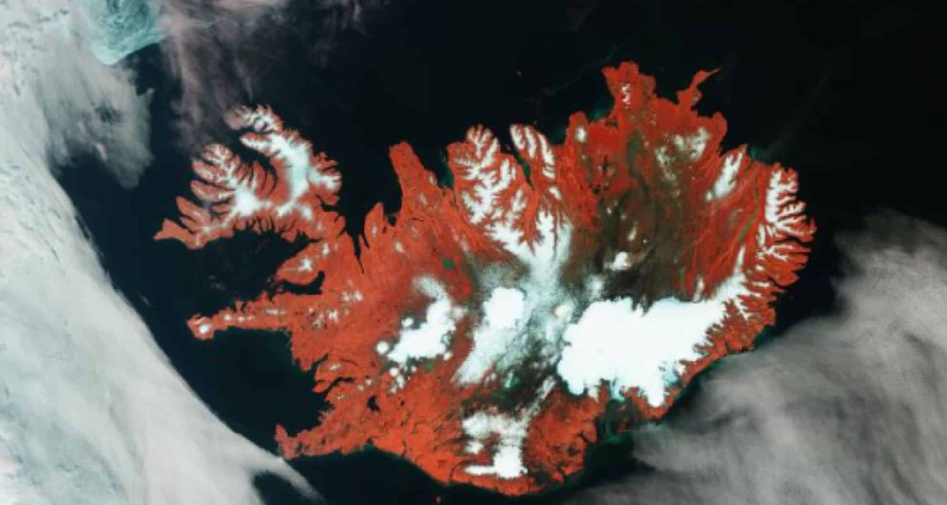
The image, processed using the near-infrared channel of Sentinel-3’s Ocean and Land Colour Instrument (OLCI), shows Iceland in a way that human eyes never could. Vegetation is rendered in vivid reds, clearly separating it from the island’s rugged, brownish lava fields and bare volcanic plains. Black zones signal the presence of fresh lava flows, while snow and glaciers dominate the eastern part of the country in clean, reflective white.
Vatnajökull, Europe’s largest glacier, is prominently visible in the eastern region, covering an enormous 8400 square kilometers. With an average ice thickness surpassing 900 meters, this glacier alone holds more frozen water than all other glaciers in continental Europe combined. In the central region, the perfectly round Hofsjökull sits like a frosted bullseye, hiding Iceland’s most active volcano beneath its icy shell. To the west, Langjökull, a massive elongated ice cap, completes the trio of glacial landmarks, each a silent witness to both climate and geological change.
Sentinel-3’s False-Color Technology Reveals More Than Beauty
What sets this image apart is not just its clarity, but the scientific intelligence packed into its color scheme. The OLCI sensor, using infrared light, enhances the contrast between vegetation, soil, and rock formations—features often indistinguishable in natural-color photography. These distinctions are critical for understanding land use, ecosystem health, and volcanic activity.
The deep emerald hues outlining rivers and lakes across the island are due to mineral-rich sediment. As glaciers melt, they feed these water bodies, which then empty into the surrounding North Atlantic Ocean. Along Iceland’s coasts, these sediments tint the ocean a brilliant green, forming a natural tracer for scientists monitoring glacial runoff and erosion dynamics.
Off the top-left edge of the island, near Greenland’s coast, light-blue swirls betray the movement of floating sea ice fragments. These are carried by wind and ocean currents, adding a dynamic frame to an already intricate landscape portrait.
An Image Caught During an Alarming May Heatwave
The timing of the Sentinel-3 flyover adds a critical layer of significance. This image was captured at the peak of a heatwave that gripped Iceland from May 13 to May 22, 2025—an event characterized by record temperatures and unusually dry skies. On the day the image was taken, Sentinel-3’s Sea and Land Surface Temperature Radiometer (SLSTR) also recorded surface heat data, contributing to long-term climate monitoring efforts.
This rare meteorological window allowed the satellite to not only capture a full visual of the country, but also collect thermal insights that may indicate the acceleration of glacial melt or soil desiccation. Scientists are particularly concerned about the frequency of such events, which might represent a shifting climate pattern for one of the most sensitive regions on Earth.