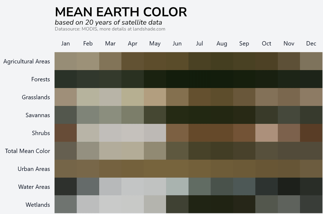
The data is from the MODIS sensors, they are on two satellites which each basically do a daily scan of the earth. One has an overpass of 10:30 AM local time, the other one at 1:30 PM. The product I’m using (MCD43A4.061) is a daily best pixel combination from both satellites.
So no night time shots, but I chose to include snow covered areas.
A note on color: Sensors on satellites (as all other cameras as well), have different spectral sensitivity than a human eye. So to map from the sensors spectral sensitivity to human eye sensitivity, it would be scientifically correct to go to CIELAB color space and from that map to a corresponding RGB value (There’s an amazing article about that [here](https://www.sciencedirect.com/science/article/pii/S0034425719300422#f0005)).
However I did not find a conversion from MODIS spectral signature to CIELAB, so I just used the same formula NASA used to generate the [Blue Marble images](https://earthobservatory.nasa.gov/features/BlueMarble). If it’s good enough for NASA it’s good enough for me!
If you want to check the colors of your own country and play a very simple wordle type game where you have to guess colors you can check out [https://landshade.com](https://landshade.com)
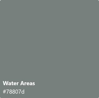
Edit: Also as noted below. This is ONLY land areas, for all of the earth, the color would be way more blue. So Water areas is also only inland lakes, which are within the boarder of a country (so for example excluding the Caspian Sea, but including Lake Baikal)
that’s creative and beautiful!
Earth as in dry land, right? Because I think the mean color of Earth would be bluer than that
This is cool.
Does the “water areas” include sea? Surprised there’s no blue tones if so
[removed]
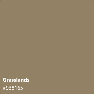
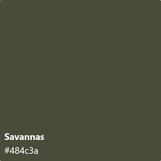
Grasslands and savanna seem backwards to me. Is savanna not like a drier grassland?
Does earth’s atmosphere distort colour?
Missed opportunity to call this project (and post) Earth Tones: 20 years of satellite data to calculate the mean colors of Earth
Could we get one adjusted by season as opposed to just month?
For people who like wearing earth tones. This is it, this is the chart for you.
How do you correct for hazy days where cloud coverage can cause desaturation?
How did you deal with differences in time of day?
Does the RGB mapping system use some sort of normalisation? (If you have two pictures of the same spot from two sattelites/sensors, do the greens appear the same? Probably not, but (how) did you compensate for that?
What about saturation normalisation?
Not trying to rain on your parade, I love your project. Just curious about these points.
What does mean color mean to anybody? I can parse it, personally.
strangley enough, some astronomers did something similar for the entire observable universe a bunch of years back and it was almost the same color, but much lighter shade lol
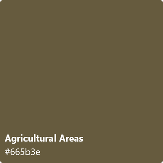
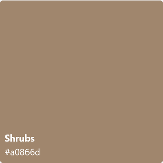
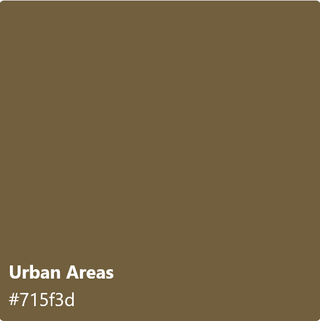
the urban and agricultural swatches look like the same colors that makeup companies think i am when i say i’m “tan” lol, this was really cool thanks for sharing.
I feel like this is how the DOD came up with the ACU pattern…
This is amazing. Is there anyway we could get the color on every grid item? I wish to reference this in the future for my own art of sorts.
I mean, nice colour palette! any of these colours is amazing for anything within the house, they give a calm vibe, could make the house cosy. Earthy colors 🌍
It seems surprisingly brown given that nearly 3/4 of the earth’s surface is water.
How are you accounting for land cover change over time in your categories?
The existence of a mean color implies the existence of a nice color.
Instead of focusing on the mean color of the earth, can we look for the nice color. Is that too much to ask from science?
Next years SUV color pallete.
So thats where us millennials get our color pallets. We’re just… worldly people
This is … awesome.
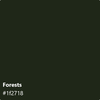
Why is Finland completely black in December in a disjointed way (i.e., it’s not a smooth transition from Nov-Dec-Jan)? I’ve been to Finland in December. It’s dark a lot, but no more than Norway (similar issue) or Sweden (seems smoother)?
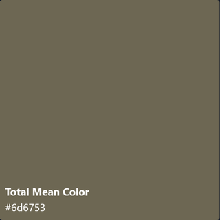
I’d love to see the monthly “Total Mean Color” added to those breakdowns.
We should be looking at a globe, not a color hex code.
If you squint your eyes, it almost looks like a minecraft dirt block
Now show me the overall mean.
I see Benjamin Moore’s 2026 featured color palette.
27 comments
The data is from the MODIS sensors, they are on two satellites which each basically do a daily scan of the earth. One has an overpass of 10:30 AM local time, the other one at 1:30 PM. The product I’m using (MCD43A4.061) is a daily best pixel combination from both satellites.
So no night time shots, but I chose to include snow covered areas.
A note on color: Sensors on satellites (as all other cameras as well), have different spectral sensitivity than a human eye. So to map from the sensors spectral sensitivity to human eye sensitivity, it would be scientifically correct to go to CIELAB color space and from that map to a corresponding RGB value (There’s an amazing article about that [here](https://www.sciencedirect.com/science/article/pii/S0034425719300422#f0005)).
However I did not find a conversion from MODIS spectral signature to CIELAB, so I just used the same formula NASA used to generate the [Blue Marble images](https://earthobservatory.nasa.gov/features/BlueMarble). If it’s good enough for NASA it’s good enough for me!
If you want to check the colors of your own country and play a very simple wordle type game where you have to guess colors you can check out [https://landshade.com](https://landshade.com)
Edit: Also as noted below. This is ONLY land areas, for all of the earth, the color would be way more blue. So Water areas is also only inland lakes, which are within the boarder of a country (so for example excluding the Caspian Sea, but including Lake Baikal)
that’s creative and beautiful!
Earth as in dry land, right? Because I think the mean color of Earth would be bluer than that
This is cool.
Does the “water areas” include sea? Surprised there’s no blue tones if so
[removed]
Grasslands and savanna seem backwards to me. Is savanna not like a drier grassland?
Does earth’s atmosphere distort colour?
Missed opportunity to call this project (and post) Earth Tones: 20 years of satellite data to calculate the mean colors of Earth
Could we get one adjusted by season as opposed to just month?
For people who like wearing earth tones. This is it, this is the chart for you.
How do you correct for hazy days where cloud coverage can cause desaturation?
How did you deal with differences in time of day?
Does the RGB mapping system use some sort of normalisation? (If you have two pictures of the same spot from two sattelites/sensors, do the greens appear the same? Probably not, but (how) did you compensate for that?
What about saturation normalisation?
Not trying to rain on your parade, I love your project. Just curious about these points.
What does mean color mean to anybody? I can parse it, personally.
strangley enough, some astronomers did something similar for the entire observable universe a bunch of years back and it was almost the same color, but much lighter shade lol
[https://en.wikipedia.org/wiki/Cosmic_latte](https://en.wikipedia.org/wiki/Cosmic_latte)
the urban and agricultural swatches look like the same colors that makeup companies think i am when i say i’m “tan” lol, this was really cool thanks for sharing.
I feel like this is how the DOD came up with the ACU pattern…
This is amazing. Is there anyway we could get the color on every grid item? I wish to reference this in the future for my own art of sorts.
I mean, nice colour palette! any of these colours is amazing for anything within the house, they give a calm vibe, could make the house cosy. Earthy colors 🌍
It seems surprisingly brown given that nearly 3/4 of the earth’s surface is water.
How are you accounting for land cover change over time in your categories?
The existence of a mean color implies the existence of a nice color.
Instead of focusing on the mean color of the earth, can we look for the nice color. Is that too much to ask from science?
Next years SUV color pallete.
So thats where us millennials get our color pallets. We’re just… worldly people
This is … awesome.
Why is Finland completely black in December in a disjointed way (i.e., it’s not a smooth transition from Nov-Dec-Jan)? I’ve been to Finland in December. It’s dark a lot, but no more than Norway (similar issue) or Sweden (seems smoother)?
I’d love to see the monthly “Total Mean Color” added to those breakdowns.
We should be looking at a globe, not a color hex code.
If you squint your eyes, it almost looks like a minecraft dirt block
Now show me the overall mean.
I see Benjamin Moore’s 2026 featured color palette.
Neat.
Comments are closed.