To learn from and build on previous efforts to map reforestation opportunities, we conducted a review of the existing literature (see “Methods”) and found 89 studies published between 2011 and 2022 (see “Data availability”). We identified seven global maps, including four original maps (FLRO, Bastin, Strassburg, and Walker maps), a modification of the FLRO map (the Griscom map), and two applications of the Griscom map (refs. 28,29). We identified ten regional maps (including two that use the FLRO map), which mainly covered tropical regions. Finally, we identified 15 national and 57 sub-national maps, which occur in 10% of all countries (i.e., 20 countries). Although some areas have high coverage (e.g., states in Brazil’s Atlantic Forest ecoregion have at least 20 maps available), most countries must rely on global or regional products for estimating reforestation opportunity (Supplementary Fig. 1).
We found that reforestation maps are generally produced using a common process, regardless of extent (Fig. 1). First, forest is defined, typically using tree cover, canopy cover, or biomass thresholds. Next, the area where forest could occur is identified (hereafter, forest potential). For example, the FLRO, Bastin, and Walker maps use biophysical constraints such as climate or soil variables to model forest potential. In other cases, as with the Strassburg map, areas of LULC change (i.e., deforestation) are used to infer forest potential. Next, the maximum area where reforestation could occur within the forest potential area is identified (hereafter, maximum reforestation potential) by accounting for practical limitations to reforestation, such as existing forest. Many maps also apply safeguards to minimize perverse outcomes and further limit the area where reforestation could occur (hereafter, constrained reforestation potential). For example, croplands are commonly removed in this step because reforestation of these lands can affect food security30 and/or result in leakage31. Some analyses then use additional factors to further evaluate trade-offs and benefits or to prioritize areas within the maximum or constrained reforestation potential (hereafter contextualized reforestation potential).
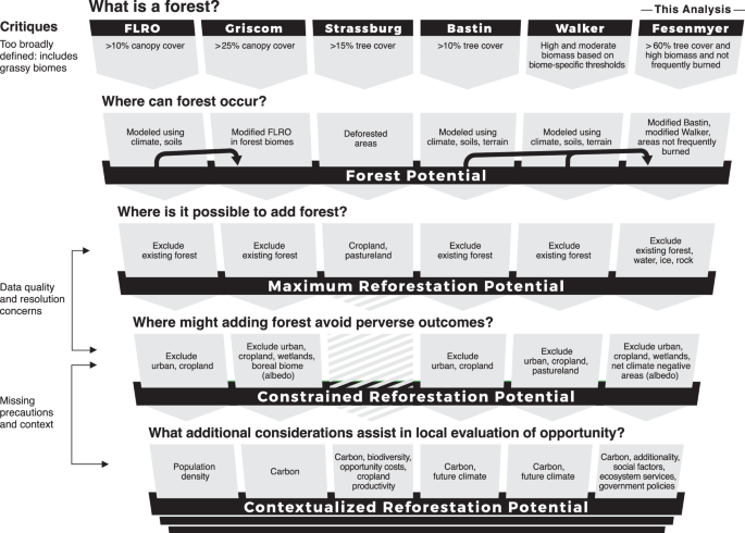
Reforestation mapping generally follows the following steps: (1) defining forest, (2) mapping forest potential (where forest can occur), (3) mapping reforestation potential within the potential forest, first as maximum reforestation potential, and then as constrained reforestation potential (maximum reforestation potential with safeguards), and (4) using overlays to provide additional information so that decision makers can evaluate the feasibility and desirability of the maximum or constrained reforestation potential given specific circumstances. Critiques from the literature associated with these steps are shown to the left. Details from unique existing global reforestation maps and this analysis are shown in columns.
Across the 89 reforestation opportunity maps, however, there is no universal standard for how spatial data is used for mapping forest potential, maximum reforestation potential, or constrained reforestation potential. These maps use 28 different types of spatial data to map where forest or reforestation potential can occur (hereafter suitability factors) and 22 different types of spatial data to map where forest or restoration cannot occur (hereafter exclusions) (Fig. 2 and Supplementary Table 1). Deforested areas, croplands, and pasture are the most frequently used suitability factors (used in 20 or more maps) (Fig. 2). Urban areas and existing forest are the most commonly applied exclusions (used in more than a third of all maps), followed by water, croplands, wetlands, and barren lands (Fig. 2). Overlays used for mapping contextualized reforestation span the greatest diversity of factors (30 across existing maps) with neighborhood metrics (e.g., forest pattern and distance to forest), economic factors (e.g., opportunity costs of the non-forest land use), terrain factors (e.g., slope), and carbon sequestration most commonly used (Fig. 2 and Supplementary Table 1). Sometimes the same factor is used as a suitability criterion, as an exclusion, and/or as an overlay in the same analysis (Fig. 2). For example, the Strassburg map uses cropland and pasture within the forest potential to identify the maximum reforestation potential and uses cropland and pasture productivity and yield to further prioritize areas within the contextualized reforestation potential.7
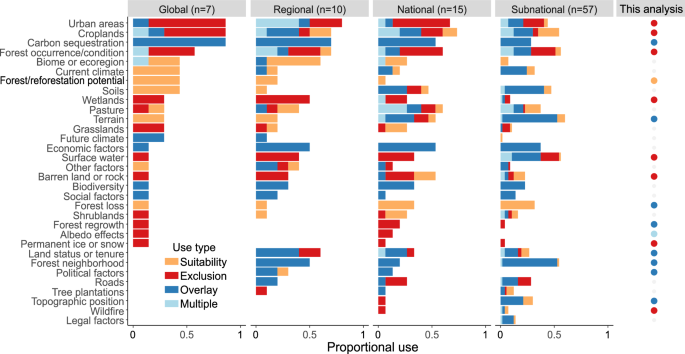
Suitability, exclusion, and overlay datasets used by peer-reviewed reforestation maps that were published 2011–2022 (n = 89), and by this analysis. Datasets are partly sorted by prevalence in a given geography, top to bottom (sorting global first, then regional, then national, then subnational). Some datasets are used consistently across scales. For example, forest loss is always used to define suitability, and economic factors are always used as an overlay. However, other datasets are used in different ways depending on the individual product and scale of the analysis. For example, croplands are used as suitability, exclusion, and overlay factors in different products or within the same product.
We compared the spatial overlap and agreement of the four original global forest potential maps (FLRO, Bastin, Strassburg, and Walker; we excluded the three global analyses1,29,32, which re-use these maps). Combining the areas identified as forest potential across the four maps results in 9455 Mha (million hectares), equivalent to 74% of global ice-free land area. Individual map estimates range from 6160 Mha (Strassburg) to 8682 Mha (Bastin) (Supplementary Table 2, see “Methods”). All four maps agree in 57% (5412 Mha) of their combined extent, but at least three maps agree in 77% (7246 Mha) (Supplementary Fig. 2). Thus, there is moderate convergence among products despite variation in how forest is defined: FLRO and the Bastin map use 10% tree cover threshold to define forests, the Strassburg map uses 15%, whereas the Walker map uses a potential biomass criterion (Fig. 1 and Supplementary Table 2).
Among the seven global analyses, five provide original maps of reforestation potential (FLRO, Griscom, Bastin, Strassburg, and Walker; we excluded one global analysis that reuses Griscom28 and another that maps reforestation potential using future land use scenarios29). For identifying reforestation potential, the Strassburg map only identifies maximum reforestation potential (1537 Mha) (Supplementary Table 2). The remaining four global maps (FLRO, Griscom, Bastin, and Walker) go further and identify constrained reforestation potential (Supplementary Table 2). The combined extent of constrained reforestation potential for these four is 4288 Mha (34% of global ice-free land area) (see “Methods”). Constrained reforestation potential varies more dramatically than forest potential among products, with nearly a 3-fold difference in extent (678 Mha in the Griscom map to 2509 Mha in the FLRO map) (Supplementary Table 2). Further, all four maps share only 23 Mha in common (0.24% of combined forest potential area, and 0.9–2.7% of individual constrained reforestation maps), though at least three maps agree in 252 Mha (3% of combined forest potential area, and 10–30% of individual constrained reforestation maps) (Supplementary Fig. 3). This striking variation is due to differences in forest potential mapping described above, as well as whether pastures are used as exclusions, and differences in the spatial resolution, time period, and LULC definitions in the datasets used to exclude existing forest, cropland, and/or pasture (Supplementary Table 2).
Mapping forest potential
Given the issues with existing reforestation maps, we created a series of reforestation opportunity maps that addressed common critiques, beginning with improvements to mapping forest potential. First, we defined forests much more conservatively, as areas that can support 60% or more tree cover, to exclude open woodlands and savannas33,34,35. Second, because there is uncertainty associated with any one product, we used multiple lines of evidence to identify forest potential by combining the two global layers that mapped uncertainty around forest potential (i.e., the Bastin and Walker maps)5,8. We restricted forest potential to pixels where the Bastin map predicts at least 60% potential tree cover, the Walker map predicts closed forest, and both maps have low uncertainty. This resulted in a preliminary forest potential area of 2393 Mha. Finally, because the Bastin and Walker models overestimate forest potential in ecosystems with frequent fires13, we eliminated areas with two or more non-cropland fires during 2002–2022, under the assumption that fire frequencies of at least two per decade can substantially limit tree density (see “Methods”). This reduced the preliminary forest potential area by 150 Mha (6.3%). These three modifications narrowed forest potential to 2242 Mha (Supplementary Fig. 4 and Supplementary Table 2), or 26–36% of the area presented by the individual FLRO, Bastin, Strassburg, or Walker maps (Supplementary Table 2).
Mapping maximum and constrained reforestation potential
To map maximum and constrained reforestation potential, we filtered our forest potential map to places where additional forests could grow given practical constraints and safeguards. We used four exclusions related to implementation limitations (existing forest, open water, bare ground, and permanent ice/snow) to identify maximum reforestation potential and five exclusions as safeguards (croplands, built-up lands, peatlands, wetlands, and albedo) to identify constrained reforestation potential (see “Methods”, Supplementary Table 3). Except for permanent ice/snow and albedo, these exclusions are all commonly used in previously published maps (more than 12 uses). For all exclusions except peatlands and albedo, we used 10–30 m resolution global products that map individual LULC types (i.e., without mosaic LULC types) for 2019–202036,37,38,39,40 to address data critiques. Implementation exclusions remove 1937 Mha (86.4%) from the forest potential map, largely due to existing forest cover (1914 Mha or 85.3% of the forest potential area), resulting in a maximum reforestation potential of 305 Mha (Table 1). Precautionary exclusions remove an additional 110 Mha (4.9%). After we apply all exclusions, we identify 195 Mha of constrained reforestation potential (Fig. 3b and Table 1).
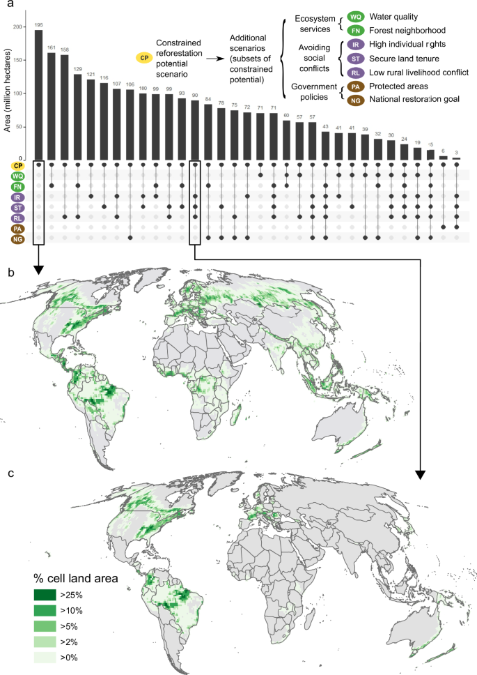
a Comparison of the area of seven scenarios to the constrained reforestation potential, and the area of agreement of 25 select scenario combinations (area shown in bars, identity of scenario combinations shown below the bars by circles), b percent land area in the constrained reforestation potential scenario by one-degree cells, and c percent land area where all avoiding social conflicts scenarios agree (intersect) within the constrained reforestation potential by one-degree cells. Panel c has less total area than panel b due to removal of areas with low individual rights, insecure land tenure, and/or potential conflict with nature-dependent livelihoods. Note that 102 other possible scenario combinations are not shown in a.
This area is 71–92% smaller than the constrained reforestation potential identified in other global products (Supplementary Table 2), and only intersects with other global products in 24–98 Mha (13–50% of the constrained potential in our map) (Supplementary Table 4). Our exclusions overlap with large areas (60–70%) identified as constrained reforestation potential in other products (Supplementary Table 4). In contrast, other global products missed substantial areas of our constrained reforestation potential because they used older or coarser resolution existing forest datasets with different criteria for forest occurrence (132–153 Mha, or 67–78% of our constrained reforestation potential) or used older and coarser cropland and/or pasture maps as exclusions (50–59 Mha, or 26–30% of our constrained reforestation potential; Supplementary Table 4).
Contextualized reforestation potential
We estimate that reforestation, if implemented in the constrained reforestation potential area, would deliver 2225 TgCO2e (teragrams of carbon dioxide equivalent) per year of net climate benefits for the first 30 years of regrowth after deductions for albedo26,28 (Table 1). The vast majority of this may represent additional climate benefit (i.e., would exceed business-as-usual forest recovery). When we calculate the ratio of forest loss to gain in one-degree cells using a 2000–2020 forest extent and change map38 (Supplementary Fig. 5), and use that ratio to proportionally scale the area and mitigation estimates in each cell, we approximate that reforestation activities would likely be additional within 169 Mha (88.7%) of the constrained reforestation potential and achieve 2086 TgCO2e per year (93.7%) of net climate benefit.
There are an estimated 98 million people who inhabit the constrained reforestation potential (Table 1). Because global maps can never fully capture the priorities of local communities, we did not attempt to prioritize areas for reforestation. Instead, we used additional overlays to help characterize what trade-offs and benefits might result within the constrained reforestation potential scenario. We clustered these into seven additional scenarios (Table 1) that subset the constrained reforestation potential based on practical considerations or on motivations for reforestation drawn from our review of existing maps and their critiques.
We created three avoiding social conflicts scenarios that sought to minimize the risk that reforestation results in injustices, displacement, and food insecurity for local communities. These three scenarios limit constrained reforestation potential to (1) countries where individuals and communities are likely able to influence decision-making through participatory or representative processes (high individual rights scenario, Supplementary Fig. 6a), (2) countries with indicators of land tenure (secure land tenure scenario, Supplementary Fig. 6b), and (3) areas without nature-dependent, vulnerable populations whose food and fuel needs may especially conflict with reforestation (low rural livelihood conflict scenario, Supplementary Fig. 6c). These scenarios total 121, 116, and 158 Mha respectively, potentially resulting in 1474, 1428, and 1591 TgCO2e per year net climate mitigation and affecting 49, 47, and 67 million people (Table 1). The three scenarios avoiding social conflicts intersect in 90 Mha (Fig. 3a, c).
We created two scenarios focused on achieving ecosystem services other than carbon sequestration: one limited to areas with high nearby forest cover (Supplementary Fig. 7a) where biodiversity outcomes may be high41 (161 Mha and 1777 TgCO2e per year net climate mitigation), and another limited to floodplain or moderate slope areas (Supplementary Fig. 7b) where water quality and climate adaptation benefits may be high42,43,44 (71 Mha and 814 TgCO2e per year net climate mitigation) (Table 1). These scenarios intersect in 60 Mha (Fig. 3a).
The final two scenarios limit the constrained reforestation potential based on government policies, either through protected areas (Supplementary Fig. 8a), where reforestation may be compatible with other management objectives and have greater durability, or forest restoration goals (Supplementary Fig. 8b), where dedicated funding, reforestation infrastructure such as tree nurseries, and other resources may incentivize reforestation. The protected area scenario has the smallest total area, mitigation opportunity, and population affected across all scenarios, at 6.3 Mha, 53 TgCO2e per year net climate mitigation, and 1.7 million people (Table 1). The national forest restoration goal scenario covers 106 Mha, 1665 TgCO2e per year net climate mitigation, and 57 million people (Table 1).
In general, we find it is hard to optimize for all factors. There are only 15 Mha where seven of the scenarios intersect (Fig. 3a) and 0.5 Mha where all eight intersect. However, multiple outcomes can be achieved. For example, the majority of the constrained reforestation potential (83%) occurs close to existing forest, where natural regeneration is likely and reforestation may enhance biodiversity41 (Fig. 3a). Similarly, the low rural livelihood conflict scenario intersects with 81% of the constrained reforestation potential (Fig. 3a), indicating that it may be possible to reforest substantial areas without negatively impacting the livelihoods of those most dependent on nature. The co-occurrence of more than half of the constrained reforestation potential in countries with restoration goals suggests there is both ample opportunity and political systems that could be conducive to enable reforestation at a broad scale (Fig. 3a). Further, even though it is difficult to meet multiple conservation objectives simultaneously (Fig. 3a), we do find 57 Mha in countries with a restoration commitment and where restoration is less likely to cause conflicts, given secure land tenure, rights of individuals, and high standards of living. (Fig. 3a).
Sensitivity tests
If we do not remove areas with frequent fire, forest potential and constrained reforestation potential increase by 7% and 24%, respectively (Supplementary Table 2 and Supplementary Fig. 9a), while if we use a 50% potential tree cover criterion (instead of 60%) to determine forest potential, then forest potential and constrained reforestation potential increase by 19% and 36% respectively (Supplementary Table 2 and Supplementary Fig. 9b). Using liberal criteria to define forest (>30% potential tree cover and lower biomass thresholds) and removing areas with frequent fire substantially increases forest potential (5095 Mha, an increase of 127%) and constrained reforestation potential (845 Mha, an increase of 333%; Supplementary Table 2 and Supplementary Fig. 9c). Using the same liberal definition of forest but without removing areas with frequent fire further increases forest potential (5788 Mha, an increase of 158%) and constrained reforestation potential (1135 Mha, an increase of 481%; Supplementary Table 2). Using alternative forest or cropland datasets as exclusions results in minor differences to the total constrained potential (1.8% and 6.6% larger area, respectively), but substantial differences in some geographies (Supplementary Tables 2 and 3 and Supplementary Fig. 10a, b). If we do not use croplands as an exclusion, constrained reforestation potential increases by 31% (to 255 Mha Supplementary Table 2 and Supplementary Fig. 10c). Finally, using different land tenure datasets in the secure land tenure scenario (Supplementary Table 5), results in 72–125 Mha of contextualized reforestation potential (62–108% of the primary land tenure scenario area; Supplementary Table 5). Thus, our results are most sensitive to the tree cover threshold used to define forest for forest potential mapping and maps of land tenure.