Amid tensions with Tehran, the Israel Defense Forces (IDF) shared a map that depicted the ‘global threat’ of Iranian missiles. However, the map incorrectly depicted India’s international boundaries and showed Jammu and Kashmir as part of Pakistan, and placed the states of the northeast within Nepal. While the IDF later apologised for the blunder, it left Indians fumingread more
A map meant to show the threat of Iranian missiles ended up causing a completely different kind of trouble for the Israeli military.
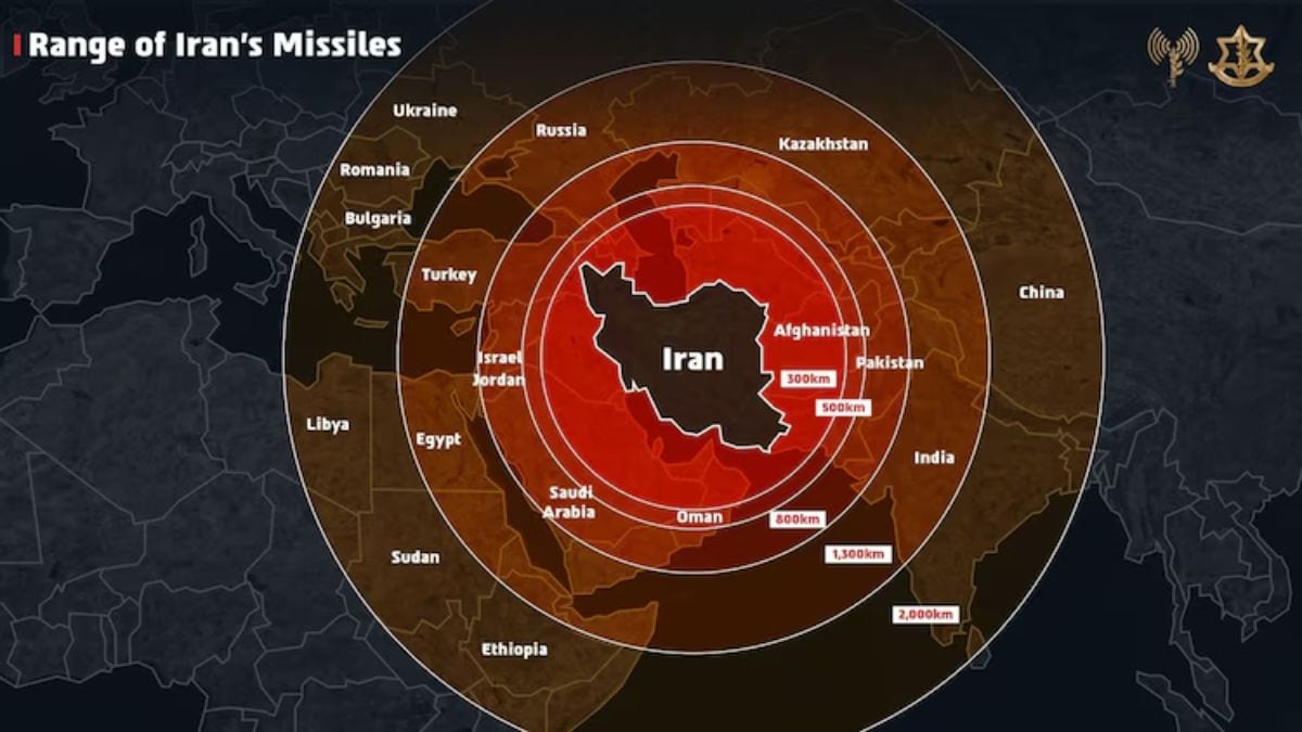
On Friday, the Israel Defense Forces (IDF) shared a map on X that incorrectly depicted India’s international boundaries. It showed Jammu and Kashmir as part of Pakistan, and mistakenly placed the states of the northeast within Nepal.
The error didn’t go unnoticed. Many Indian users quickly pointed out the blunder, calling it unacceptable and demanding that the IDF take the post down. Some even tagged Israeli Prime Minister Benjamin Netanyahu directly.
As the backlash grew, the IDF stepped in to acknowledge the mistake.
Here’s a closer look at what happened.
IDF’s map blunder
Amid an escalating military conflict with Iran, the Israel Defense Forces (IDF) shared a stylised map on X, warning of Tehran’s “global threat” by showing the estimated reach of Iranian missiles.
“Iran is a global threat. Israel is not the end goal, it’s only the beginning. We had no other choice but to act,” the Israeli military wrote in the post, adding a map that spanned West Asia, North Africa, Europe, and parts of Asia, including India, with incorrectly drawn borders.
Iran is a global threat.
Israel is not the end goal, it’s only the beginning. We had no other choice but to act. pic.twitter.com/PDEaaixA3c
— Israel Defense Forces (@IDF) June 13, 2025
It omitted Jammu & Kashmir and Ladakh, which are constitutionally integral parts of India. Aksai Chin, which is part of Ladakh, was also excluded from Indian territory. Arunachal Pradesh was also misrepresented.
The graphic featured red concentric circles originating from Iran, highlighting the missile reach over neighbouring countries such as Saudi Arabia, Libya, Ethiopia, India, China, Russia, Turkey, and parts of Europe like Romania and Bulgaria.
Catch live updates about Israel-Iran conflict here
Soon after the post went live, Indian users flooded the comments. Many expressed disappointment and anger, calling the map misleading and insensitive.
“Forget precision, it’s no way near the truth. Why not change it rather than posting this sorry note? You need to understand India sentiments and our relationship. Better late than never, change it ASAP plz,” one user replied.
Another tagged Israeli PM Benjamin Netanyahu and demanded the map be deleted and re-posted with the correct borders. Some users even reminded Israel of India’s historical support and the sacrifices made by Indian soldiers in defence of the country’s territorial integrity.
So far, the Indian government has not officially responded to the incident.
IDF admits mistake, issues apology
In the face of mounting criticism, the IDF eventually admitted its mistake and issued a public apology.
“This post is an illustration of the region. This map fails to precisely depict borders. We apologise for any offence caused by this image,” the IDF posted on X.
This post is an illustration of the region. This map fails to precisely depict borders. We apologize for any offense caused by this image.
— Israel Defense Forces (@IDF) June 13, 2025
The timing of the error struck a particularly sensitive chord because of the strong ties shared between India and Israel in recent years. In 2017, Prime Minister Narendra Modi became the first Indian leader to visit Israel, marking a key moment in bilateral relations.
Since then, the relationship has grown steadily. India is now one of Israel’s largest trading partners, behind only the US, UK, Hong Kong, and China, and a major buyer of Israeli defence equipment. With such strong ties, many found the map blunder unexpected and disappointing.
Indian Prime Minister Narendra Modi (L) and Israeli Prime Minister Benjamin Netanyahu (R) sign the guest book at the Indian Army Cemetery of World War I to honour fallen Indian soldiers, in the Israeli coastal city of Haifa July 6, 2017. File image/ Reuters
Meanwhile, the map was originally shared as part of Israel’s messaging around its latest military action—
Operation Rising Lion
. On Friday, Israel launched massive airstrikes on Tehran, claiming it was targeting Iran’s nuclear enrichment infrastructure.
The strikes reportedly killed over 70 people, including several high-ranking Iranian military commanders, and destroyed key facilities.
In retaliation, Iran launched a barrage of drones and missiles targeting several areas in Israel, including Tel Aviv and Jerusalem, following a stern warning from its military that “everyone will feel it.”
By Saturday, the situation had worsened further, with additional waves of offensive attacks from both sides.
With input from agencies