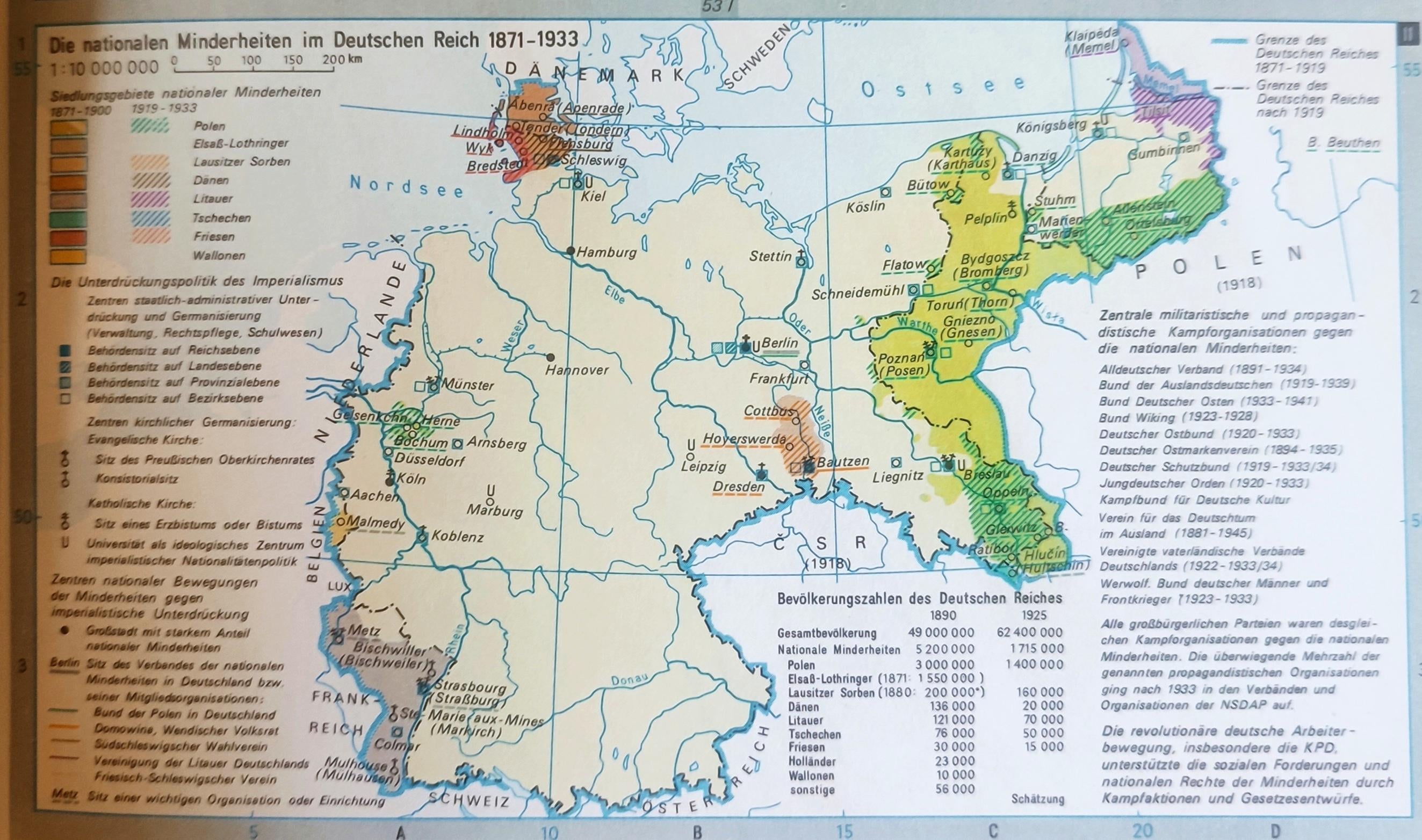
Interesting ethnic map of the German Empire from an East German atlas; territories to be ceded to Poland after the war are shown as having an overwhelming Polish majority
by Rigolol2021
Interesting ethnic map of the German Empire from an East German atlas; territories to be ceded to Poland after the war are shown as having an overwhelming Polish majority
by Rigolol2021
7 comments
Are they? Looks like a lot that was ceded was overwhelmingly German to me.
Go to AskAGerman and they say that there was no Poles and Kashubians in Pommerania and germanic tribes were first🤣
The map says “settlement areas of national minorities”. Nowhere does it say anything about an “overwhelming Polish majority”. This is fake news.
Here’s a 2024 map for comparison
https://preview.redd.it/5g75cyv8bg8f1.png?width=720&format=png&auto=webp&s=9edee5564fe6d221fa17b6aa11d78630cbf8f82c
That of course does not imply those minorities are the majority in the highlighted areas. Far from it.
Maybe because East Germany were Poland’s/USSR ally?
wreschen is german city
As others have mentioned, the map shows the “settlement areas of national minorities.” While there were indeed regions with a Polish majority (e.g Posen)not all of the territories ceded after World War I had a clear Polish majority. The issue is quite complex, as there were many mixed marriages in then-eastern Germany, and numerous people had Polish surnames but identified as German and vice versa
In some areas, such as around Katowice, referendums were held to decide whether certain regions would remain part of Germany or become part of Poland. Some of these territories were eventually given to Poland, while others stayed with Germany.
But even after the partition, many Poles continued to cross into Germany daily for work.
And a fun fact: a small territory was also ceded to Czechoslovakia.
It shows Mazurians (who fled Poland after she annected Mazovia to live as loyal Prussian subjects and never looked back, ultimately leaving for Germany after 1945) and Silesians (with whom Poland broke the ties to pursue Lithuanian union in 1400s) as Polish. It also shows Royal Prussians (a fiercly separate identity in Commonwealth that spoke both Polish and German but identified as neither) as Polish.
The only Poles on this map are Kuyavians and Greater Poles. Rest is lies and statistics.
Comments are closed.