Can we get a version of this map with the peaks tinted to reflect party registration or voting margins? Might help some people with the whole “land doesn’t vote” thing.
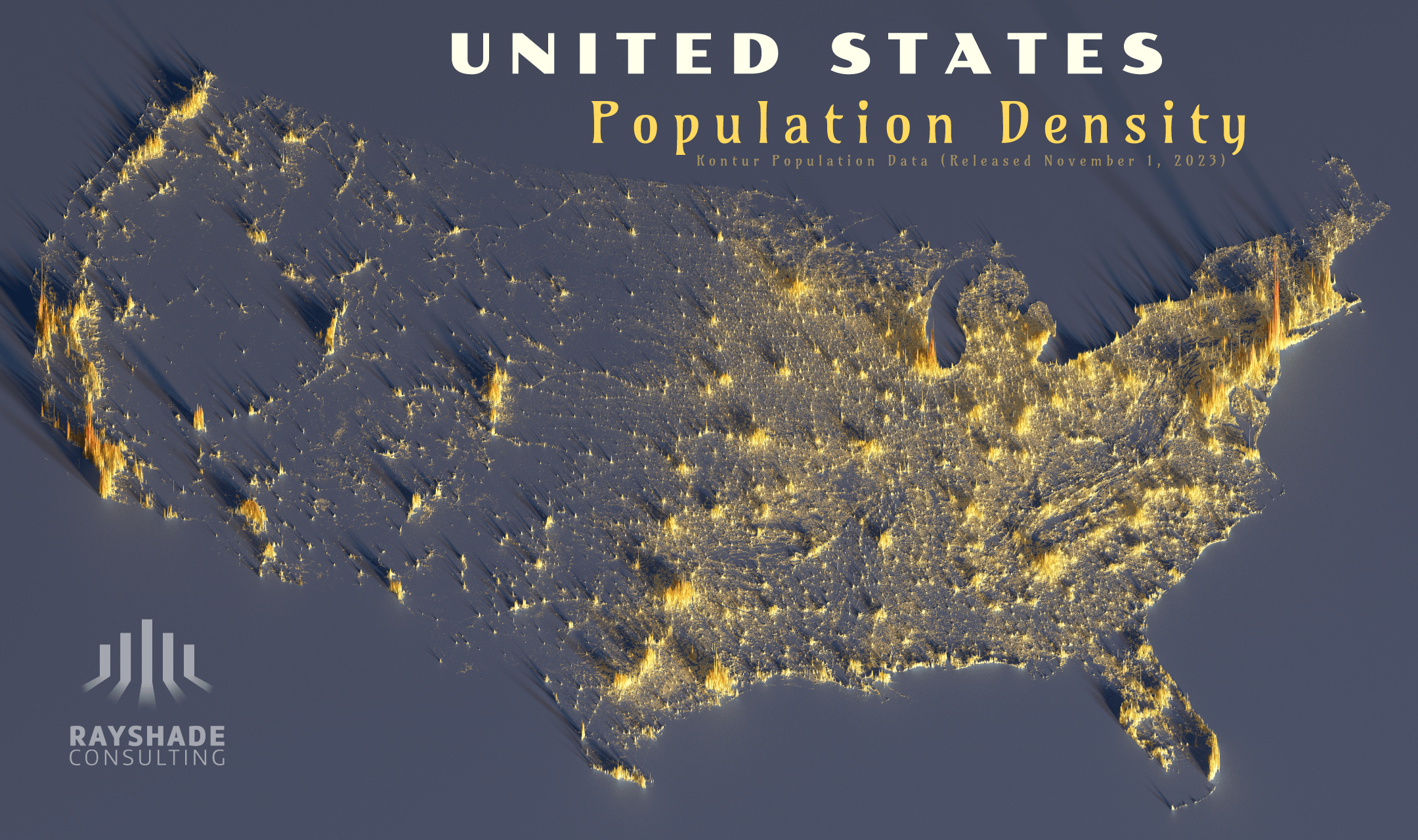
This is a great visualization. I’ll tell ya, coming from the east coast, I was blown away by the vast expanse of nothingness I saw when I became a sales rep in the mountain states for about 3 years. In certain areas, you could drive for an hour without seeing virtually anything man made aside from a fence on either side of the road.
I am from the West Coast. The East Coast always weirds me out because there are people everywhere and I am not talking about the bug cities. There should be people in the big city but you go out into the “country” and there are mfs everywhere. I find it odd.
It’d be interesting to compare this map to an elevation map
Absolutely gorgeous visualization.
Great looking map, one of the best I’ve see. Would be cool to see Canada as well, it almost all fits on this map as they are all very close to the border. Would be interesting to see them in a different color just to show how much more it adds to the north east, another 11 million or so in that area. Such a wild population density in a small area combined with north east USA.
Most of the people that migrated from Europe and other regions of the world ended up in the eastern parts of the US and they just sorta stay there lol.
That makes sense I guess. Those early societies first started developing in the East and then some of them started going Westward.
The main outlier on the west coast is California with 39 million people + currently being the world 4th biggest economy.
40% of the US are in the West and Northeast regions. The other 60% are in the South and Midwest regions.
Cali is carrying the West and Texas + Florida are carrying the South hard in this department.
This data **is** beautiful, well done!
Great map! It’s crazy how you can clearly see I-35 as a national dividing line without it even being marked.
There’s a clear “line” there where the density stops, and it’s west of the Mississippi but east of the Rockies. Why does the density drop so much at that longitude?
Edit: when I drive east from my current state to my home state I do notice a big humidity/flora difference around mid-Oklahoma about where the “line” is.
Edit 2: It’s the 100th Meridian, and it does mark a geographic boundary where average rainfall changes, which also explains the change in population density. Neato: https://en.m.wikipedia.org/wiki/100th_meridian_west
![Population density of the contiguous United States [OC]](https://www.europesays.com/wp-content/uploads/2025/07/1752008292_71r69nk21pbf1-1920x1024.png)
11 comments
this would be awesome as an interactive app
Can we get a version of this map with the peaks tinted to reflect party registration or voting margins? Might help some people with the whole “land doesn’t vote” thing.
This is a great visualization. I’ll tell ya, coming from the east coast, I was blown away by the vast expanse of nothingness I saw when I became a sales rep in the mountain states for about 3 years. In certain areas, you could drive for an hour without seeing virtually anything man made aside from a fence on either side of the road.
I am from the West Coast. The East Coast always weirds me out because there are people everywhere and I am not talking about the bug cities. There should be people in the big city but you go out into the “country” and there are mfs everywhere. I find it odd.
It’d be interesting to compare this map to an elevation map
Absolutely gorgeous visualization.
Great looking map, one of the best I’ve see. Would be cool to see Canada as well, it almost all fits on this map as they are all very close to the border. Would be interesting to see them in a different color just to show how much more it adds to the north east, another 11 million or so in that area. Such a wild population density in a small area combined with north east USA.
Most of the people that migrated from Europe and other regions of the world ended up in the eastern parts of the US and they just sorta stay there lol.
That makes sense I guess. Those early societies first started developing in the East and then some of them started going Westward.
The main outlier on the west coast is California with 39 million people + currently being the world 4th biggest economy.
US population % in term of regions:
https://www.census.gov/popclock/data_tables.php?component=growth
40% of the US are in the West and Northeast regions. The other 60% are in the South and Midwest regions.
Cali is carrying the West and Texas + Florida are carrying the South hard in this department.
This data **is** beautiful, well done!
Great map! It’s crazy how you can clearly see I-35 as a national dividing line without it even being marked.
There’s a clear “line” there where the density stops, and it’s west of the Mississippi but east of the Rockies. Why does the density drop so much at that longitude?
Edit: when I drive east from my current state to my home state I do notice a big humidity/flora difference around mid-Oklahoma about where the “line” is.
Edit 2: It’s the 100th Meridian, and it does mark a geographic boundary where average rainfall changes, which also explains the change in population density. Neato:
https://en.m.wikipedia.org/wiki/100th_meridian_west
Comments are closed.