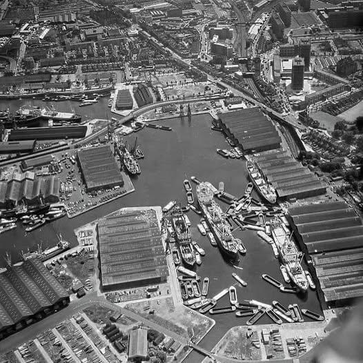
Just checked this out on Google Maps. This picture is looking south, the pool is now about half its size and has Surrey Quays underground station to the top right. The train track still dives underground at the same place.
The channel and smaller pool to the left have gone, but the main Surrey Quays pool is still there (top left) although only a stub of the connecting canal exists.
Hard to imagine. Is this looking south east towards Surrey docks?
I lived in Rotherhithe for a bit and used to go jogging round Stave hill, which I understand was a feature of the redevelopment of the area in that they needed to dump soil and stuff somewhere. My favourite memory though is when I used to go out jogging and had a double digit BMI.
5 comments
Just checked this out on Google Maps. This picture is looking south, the pool is now about half its size and has Surrey Quays underground station to the top right. The train track still dives underground at the same place.
The channel and smaller pool to the left have gone, but the main Surrey Quays pool is still there (top left) although only a stub of the connecting canal exists.
Hard to imagine. Is this looking south east towards Surrey docks?
I lived in Rotherhithe for a bit and used to go jogging round Stave hill, which I understand was a feature of the redevelopment of the area in that they needed to dump soil and stuff somewhere. My favourite memory though is when I used to go out jogging and had a double digit BMI.
Nice neck of the woods.
https://preview.redd.it/qpwuqvo1docf1.png?width=1080&format=png&auto=webp&s=cd57023d4a53f36f2b3ca226498976cda86a14f8
Hmm. Potato camera.
So different now!
https://preview.redd.it/hac8zzbtvpcf1.jpeg?width=5712&format=pjpg&auto=webp&s=f871de2cc731b437afd6d146744aba5bd7a35370
Comments are closed.