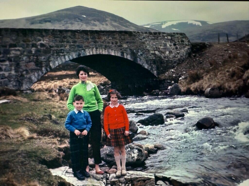
Does anyone recognise this location?
It was sent to me from family in NZ who thought I would know this place, but I don't recognise it. Looks like somewhere in the East. I thought maybe Glen Clunie (south of Braemar) but Google maps/Streetview hasn't helped me to identify the location.
by Vodkaboris
35 comments
Skye?
https://en.m.wikipedia.org/wiki/Clunie_Water
Kodachrome, you give us those nice bright colors…
Brigadoon
Sligachan bridge on Skye
I think it’s Bridge of Orchy and Allt Tolaghan. Happy to be corrected.
Colours are insane
There on the stair, right there!
Correct me if I’m wrong, but isn’t this the bridge over the Scarisdale River on Mull?
Stoneybridge
Where’s yellow?
Sssssstonybridge.
I think this might be on the A822, newton bridge over the river almond. https://maps.app.goo.gl/wd53UdsukYXXucvS9?g_st=ac
After a wee google I think it might be the Drochaid Tolaghan Bridge near Bridge of Orchy?
Edit: it won’t let me upload a photo. Hoping this link might work [link](https://www.geograph.org.uk/photo/4555419)
1973?
I’ve got a painting my gran done of an almost identical looking bridge but I’ve no idea where it’s from. She was brought up around Moffat then borders area.
When I was a kid my brother locked us out of the car and we hid under a bridge to get away from the rain. Looks similar but not sure https://maps.app.goo.gl/kr3ywU2knNuZUShRA?g_st=ac. Grey Mares Tail
Any one thought about asking Jose Monkey
It looks a bit like from the river esk in glen clova by the lower gella bridge car park ( possibly to the right of the photo)
It looks a bit like it but by no means sure
e2a: the bridge that is there now is concrete and steel and looks to be <30years old. The mountains don’t really look right so likely not it
Grey mare’s tail bridge near the car park?
I was thinking it looks a bit like the Bridge of Orchy near Glencoe.
That mum is a beauty
Inveroran for sure! A popular wild camp spot for the west highland way walk!
What is is about old cameras that made Scotland look so grim?
Orchy
It’s the old A9 by the Drummochter Munros. See street view and compare hills in the background
https://maps.app.goo.gl/SeS6QiAzjt2CF7PG6?g_st=ac
Looks like bridge of orchy.
Legit thought that was a pic of the queen, Anne & Charles. Think I should put on my glasses 😆
The stone bridge over the Russel Burn on Bealach na Ba road?
https://preview.redd.it/u5wjtnhvjvhf1.jpeg?width=600&format=pjpg&auto=webp&s=1d88174df0b285352888815b85ca61db3847f9c2
I thought this was somewhere along the way to glencoe as there’s a bridge somewhat like this just off the A82 once you’re past Bridge of Orchy. The peak looks familiar as well
The things that are distinctive about that bridge are the flat parapet, the sharp angle at the end, and the arch stones which seem to be a bit squarer and more regular. Most of the older bridges being suggested as candidates have a pronounced curve, and the arch tends to be built of longer, narrower, less neatly dressed stones. I can’t find anything that seems to be a good match, using Google Lens.
It could be any one of 6 or 7 bridges on the road from Lairg to Tongue. They are all of a similar design.
Can any geoguesser genius types match the mountain via height/ scale etc.???
Honestly, on first viewing, I was convinced it was over Glencoe way. I have 100% driven past it but I can’t put my finger on an exact location.
Then thought Sligachan bridge but google tells me thats more sloped than I remember.
Mainly commenting now so I can come back later and hopefully someone’s got it right.
I thought it might be a bridge somewhere on the road past the Glenshee ski centre.
The hill in the background looks like one of the Drumochter hills – maybe this is a bridge on the A9 before that section was dualled?
Comments are closed.