Paul McColgan
McColgan Seismic Interpretation Services LLC
Cincinnati
Nilesh Dixit
Arizona State University
Glendale
Jacob T. Murchek
US Geological Survey
Reston, Va.
Development of Umiat oil field on Alaska’s North Slope has been hindered by geological and logistical difficulties. Discovered more than 80 years ago, the field experienced minimal drilling, and initial assessments indicated that oil deposits were primarily contained within low-pressure permafrost zones. Recent advancements in seismic technology, particularly amplitude variation with offset (AVO) analysis, however, redefined the potential of the Umiat anticline.
Reconditioned existing 3D seismic data identified significant hydrocarbon related anomalies which suggested deeper, more conventional reservoirs lying beneath the permafrost zone, mitigating previous production issues. This new seismic interpretation expands the field’s potential oil in place to more than 2 billion bbl, doubling prior estimates.
A newly-defined, unleased prospect (Tukkuttok) exists under normal pressure conditions and may make commercial production feasible. With potentially high-quality light crude oil and favorable reservoir conditions, Umiat could have broader implications for Arctic oil exploration.
North Slope
Alaska’s North Slope encompasses the Alaska Outer Continental Shelf and the Brooks Range foothills and contains an estimated 60 billion bbl of in-place light and heavy crude oil.1 As many of its northern fields reach maturity, however, focus has shifted toward identifying new reserves and maximizing untapped resources.
Advancements in drilling and completion technologies (e.g., horizontal drilling) combined with a deeper understanding of the region’s complex geology have recently led to major discoveries in the Brookian sequence reservoirs, with some as large as 1-2 billion bbl.2 One potentially promising yet underdeveloped field is Umiat. It presents a potential opportunity for future development with more than 1 billion bbl oil in place within Brookian reservoirs.3
Despite being discovered more than 80 years ago, Umiat has seen minimal drilling activity, with only 13 wells drilled and no significant production due to geological and logistical difficulties.4 Until 2019, its oil accumulations were thought to be confined solely to low-pressure permafrost rocks, classifying it as an unconventional resource. With advanced analysis of seismic attributes and modern drilling techniques, however, Umiat holds potential as a major oil-producing region.
Umiat oil exploration
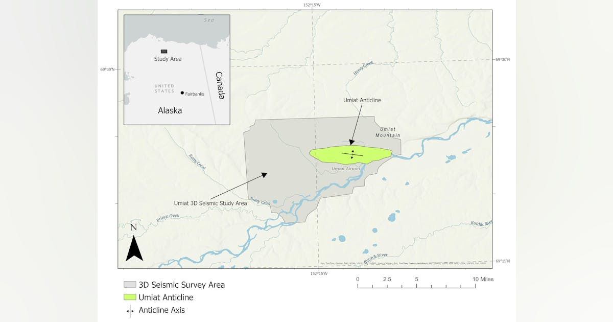
Oil and gas exploration in Alaska’s Arctic region dates to the US Navy’s exploration program between 1944 and 1953. During this period, the Navy conducted drilling operations in Naval Petroleum Reserve No. 4 (now recognized as the National Petroleum Reserve Alaska) to assess its hydrocarbon potential. One of the primary targets of this initiative was the Umiat anticline, a geologic structure in the southeastern corner of the reserve on the north side of the Colville River (Fig. 1). The anticline extends east to west measuring about 3 miles wide and 10 miles long.
During this exploration phase, a total of 11 wells were drilled on the anticline with 572-6,212 ft depths. The most significant oil shows were encountered at 660-760 ft depths within the sands of the lower Grandstand interval of the Cretaceous Nanushuk formation. These oil-bearing sands, however, were within the permafrost zone which extends about 900 ft below the surface, presenting unique drilling and production difficulties.
The results of the Navy’s drilling program at Umiat provided insights into the structure and reservoir characteristics of the field. The first well, Umiat Test Well #1, was drilled to a depth of 6,005 ft and encountered multiple oil shows in the Grandstand interval. However, it failed to produce hydrocarbons during testing and was ultimately plugged and abandoned.
Further analysis revealed that the well had intersected a reverse fault with a vertical displacement of 775 ft and had been drilled 5 miles west of the anticline’s apex, potentially explaining its lack of production.
Subsequent drilling focused on delineating the reservoir. Test Wells #2-#5 were drilled along the crest of the anticline, whereas Test Well #6 and Test Well #7 targeted the southern flank, and Test Well #11 targeted the northern flank.
Test Well #2 encountered oil shows in the Grandstand interval but failed to produce oil and was classified as a dry hole. Test Well #3 achieved a flow rate of 24 bo/d from the Grandstand interval, but freshwater drilling mud infiltrated the reservoir and froze within the formation, raising concerns about flow restrictions.
To address these issues, the mud system was switched to a brine-based solution for Test Wells #4 and #5. Test Well #5 was positioned 200 ft east of the dry hole Test Well #2. The mud adjustment resulted in significantly improved production, with Test Well #4 producing 100 bo/d, and Test Well #5 achieving 400 bo/d, the highest flow rate among all vertical wells drilled on the anticline.
On the southern flank, additional wells were drilled to determine the oil-water contact. Test Well #6 was intended to reach the lower Grandstand interval, but mechanical issues prevented the well from being drilled deep enough to confirm the full extent of the reservoir. Test Well #7, which was positioned even farther down-dip, was the lowest well structurally positioned on the anticline’s south limb. It yielded only minor oil shows in the Nanushuk formation, with no indications of hydrocarbons in either the upper or lower Grandstand interval. Test Well #11, which was drilled on the north flank of the structure, contained water with no significant oil shows.
Despite the logistical and technical difficulties encountered during these early drilling campaigns, several wells demonstrated flow rates between 60 and 220 bo/d, confirming the presence of a working petroleum system within the Umiat anticline. Low reservoir pressure, permafrost conditions, and the absence of infrastructure prevented commercial viability at the time. These early exploration efforts laid the foundation for modern evaluations of Umiat’s potential. Advancements in seismic imaging, drilling technology, and production techniques offered new opportunities to map the field.
In 2007 and 2008 Renaissance Alaska LLC conducted an 82-sq mi proprietary 3D seismic survey from the Umiat anticline with the primary objective of imaging deeper structural features to assess the potential for additional oil prospects.5 The presence of oil in the shallower Grandstand interval provided the rationale behind this exploration and led to the hypothesis that deeper reservoirs could also contain hydrocarbons. To the best available knowledge, however, no significant deep prospects were identified or drilled based on this survey.
Between 2008 and 2012, research efforts at Umiat shifted toward evaluating techniques for producing oil from a permafrost-affected reservoir. The University of Alaska Fairbanks Geophysical Institute, in collaboration with two energy companies and with financial support from the Department of Energy, led studies aimed at overcoming difficulties associated with extracting hydrocarbons from frozen formations. During this time, additional wells were drilled, including a horizontal well on the crest of the anticline, to enhance production. Despite these efforts, the project failed to yield commercially viable results.
Drilling activity at Umiat continued until 2014 but, without significant breakthroughs in production, development efforts stalled.6 The asset remained largely dormant until it was acquired by 88 Energy in 2021. A notable turning point occurred in 2018 when the proprietary rights for the Umiat 3D seismic data expired, making the dataset publicly available through the State of Alaska.
This development opened new opportunities for independent evaluations of the field’s potential, setting the stage for a renewed exploration phase leveraging advanced seismic interpretation techniques.
New Umiat AVO interpretationThe new fully corrected, three-dimensional pre-stack time migrated (PSTM) data gathers identified direct hydrocarbon indicators (DHI) in Umiat. Previous interpretations focused on mapping structural features and stratigraphic trends in the stacked seismic section and paid only minor attention to pre-stack seismic attribute analysis (Fig. 2).