Construction of Jerusalem’s Blue Line light rail project began Sunday, marking a major milestone in the city’s expanding public transportation network. The 24-kilometer line will include 40 new stations and is expected to serve roughly 250,000 passengers daily.
It will operate alongside the existing Red and Green lines, connecting key neighborhoods across the capital, but at a significant cost to traffic and pedestrian access in the coming years.
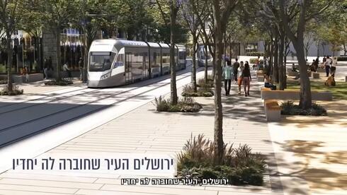
Simulation video of the Blue Line in Jerusalem
(Photo: Jerusalem Transportation Master Plan)


Work will start on King George Street, one of the city’s main thoroughfares, which will be partially and permanently closed to traffic. The project is not expected to be completed before 2029, and will cause long-term disruptions to public transportation routes and road access in the city center.
As part of the construction, a 2-kilometer tunnel will be excavated at the Jaffa-Strauss intersection.
During this phase, King George and Strauss streets will be closed to public transportation between Ben Yehuda and HaNevi’im streets.
Bus lines will be rerouted through alternative routes in central Jerusalem. When construction is complete, both streets will become pedestrian promenades with light rail access, similar to Jaffa Street today.
The Blue Line will introduce three new service routes – Gilo to Ramot, Malha to Har Ha’tzofim (Mount Scopus), and Givat HaMatos (in east Jerusalem) to Hadassah Ein Kerem – and will integrate with the five existing service lines of the Red and Green routes.
The full network will form Israel’s first advanced light rail system built to international standards.
3 View gallery
")
Illustration of the blue line
(Photo: The Jerusalem Transportation Master Plan)
However, the road ahead will be long and disruptive. The affected streets are already heavily congested, and the four-plus years of construction are expected to worsen traffic and limit pedestrian mobility.
The Blue Line is expected to gradually open between 2029 and 2031.
The project will be carried out in two main phases. In the first, the Moriah Jerusalem Development Corporation will relocate and upgrade underground infrastructure. This phase will take place Sunday through Thursday from 7 a.m. to 7 p.m., with additional work on Fridays as needed. A tunnel portal will be constructed on Strauss Street.
Once this stage is complete, the city will carry out urban development work including sidewalks, greenery, benches and street lighting. Night work will be concentrated at intersections, in coordination with police directives.
3 View gallery
")
Israel’s first advanced light rail network
(Photo: The Jerusalem Transportation Master Plan)
In the second phase, rail tracks will be laid and stations built with minimal disruption to surrounding vehicular and pedestrian traffic.
New traffic arrangements will take effect immediately. King George and Strauss streets, between Ben Yehuda and HaNevi’im, will be permanently closed to public and private vehicles.
The stretch of King George between Shmuel HaNagid and Ben Yehuda northward will be open only to public transportation; private cars will be diverted to Shmuel HaNagid Street.
Southbound traffic between Strauss and Shmuel HaNagid will also be blocked, and public transit will be rerouted to Eliash and Shmuel HaNagid streets.
Throughout the project, pedestrian access will be maintained and local businesses will continue operating as usual.
3 View gallery
")
Expected changes to traffic arrangements
(Photo: The Jerusalem Transportation Master Plan)
Public transportation routes will undergo major changes. With southbound traffic closed on King George and Strauss streets, new alternate routes will serve city bus lines.
An eastern corridor will run along David HaMelech, Shlomo HaMelech, Shivtei Yisrael and HaNevi’im streets.
A western corridor will pass through King George/Shmuel HaNagid, Bezalel (toward Mount Scopus), Eliash, Ki’akh and HaNevi’im streets.
Additional lines will use King George/Shmuel HaNagid, Eliash, Kiakh and HaNevi’im.
Details of the changes to bus routes will be shared through various channels, including printed notices, street teams and digital platforms.
To offset parking that will be lost during construction on Shmuel HaNagid, alternative parking will be provided at the Ma’alot Street parking lot.