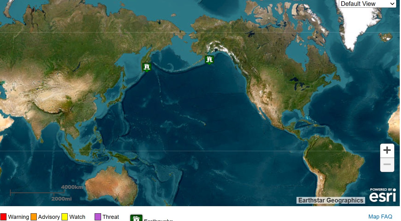
A massive 7.8 magnitude earthquake struck Russia’s Kamchatka region at around 3 p.m. ET on Thursday, sparking concerns of a potential tsunami along the U.S. West Coast and Hawaii.
NOAA and the National Weather Service’s U.S. Tsunami Warning System has since confirmed that a Pacific-wide tsunami is not expected and that, “there is no tsunami threat to Hawaii.”
What To Know
An earlier tsunami advisory for parts of Alaska’s Aleutian Islands has been canceled.
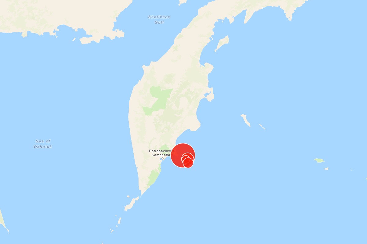
The quake occurred about 80 miles east of Petropavlovsk-Kamchatsky, Russia, at a depth of six miles.
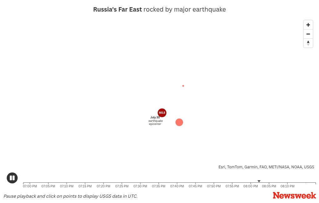
The earthquake occurred just two months after a 8.8 magnitude earthquake shook the same region in Russia in July.
Newsweek’s live blog is closed.
07:47 PM EDT
Graphic shows quake economic losses of up to 1 percent of Russia’s GDP
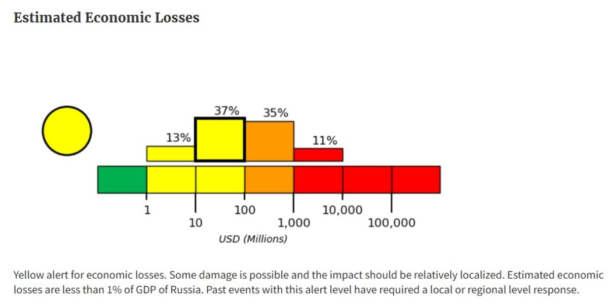
A new graphic shows economic losses of up to 1 percent of Russia’s GDP following the 7.8 magnitude quake on Thursday.
The USGS graphic shows estimated losses worth between ten million and up to a billion.
The damage from the earthquake is expected to be relatively localized.
A new graphic shows economic losses of up to 1 percent of Russia’s GDP following the 7.8 magnitude quake on Thursday. The USGS graphic shows estimated losses worth between ten million and up to a…
A new graphic shows economic losses of up to 1 percent of Russia’s GDP following the 7.8 magnitude quake on Thursday. The USGS graphic shows estimated losses worth between ten million and up to a billion.
More
USGS
07:35 PM EDT
New graphic shows estimated fatalities after Russian earthquake.
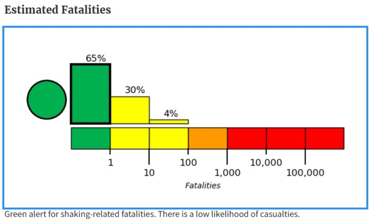
A new graphic, from USGS, shows the estimated fatalities after Russian earthquake.
The graph shows that there is a low likelihood of casualties following the 7.8 magnitude quake.
There have not been any reports of deaths since it struck around 3 p.m. ET.
New graphic shows estimated fatalities after Russian earthquake. Courtesy of USGS.
New graphic shows estimated fatalities after Russian earthquake. Courtesy of USGS.
USGS
06:50 PM EDT
Quake follows strong earthquake near Alaska this week
A 5.2 magnitude earthquake struck off the coast of Alaska’s Aleutian Islands earlier this week, the U.S. Geological Survey (USGS) said.
There was no immediate tsunami warning issued after the quake at around 1 a.m. local time in Nikolski, Alaska, on Tuesday, September 16.
The USGS said the quake had a depth of 10 kilometers (6.2 miles). It struck 122 kilometers (75.8 miles) south-by-southwest of Nikolski.
A similar-sized earthquake in the same area occurred on September 6, but it was of a greater depth and 30 miles closer to the coastline. It likewise did not trigger a tsunami warning.
According to the Alaska Earthquake Center, the Aleutian megathrust is the primary cause of the strongest earthquakes in the region.
The Aleutian megathrust is a major subduction zone fault, an area where two tectonic plates meet.
Along this fault is where the Pacific Plate is forced beneath the North American Plate, causing substantial seismic activity.
06:26 PM EDT
New map shows all tsunami threats, advisories, lifted
New map from tsunami.gov shows the all-clear after tsunami advisories were lifted following the Russian earthquake
New map from tsunami.gov shows the all-clear after tsunami advisories were lifted following the Russian earthquake
tsunami.gov
05:59 PM EDT
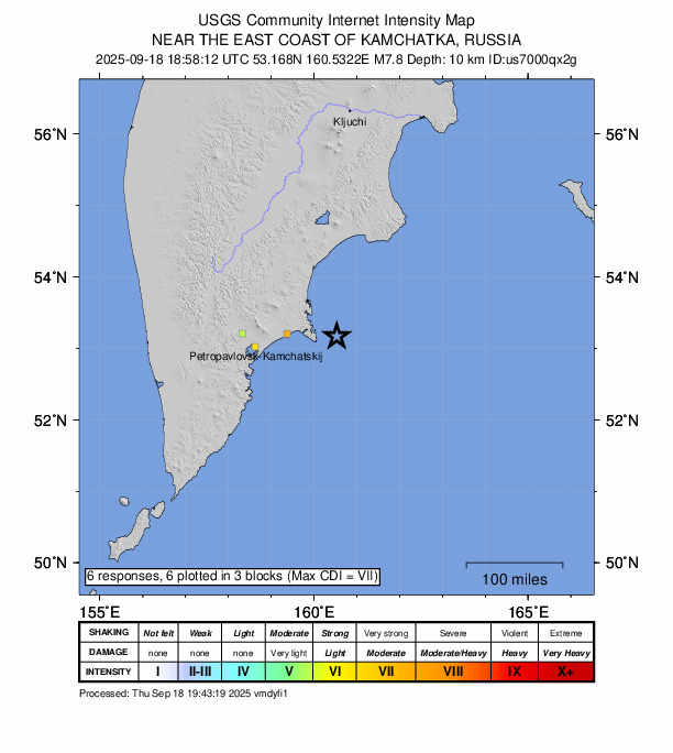
More than 240,000 felt strong shaking in the earthquake
A map from the USGS reveals the populated areas which felt the 7.8 magnitude quake which occurred about 80 miles east of Petropavlovsk-Kamchatsky, Russia, at a depth of six miles.
Around 241,000 felt “strong” shakes, while 33,000 felt moderate and 11,000 only felt light shaking, according to the USGS.
No one felt very strong, severe or even extreme shaking.
Estimated Population Exposure to Earthquake Shaking
Estimated Population Exposure to Earthquake Shaking
USGS
05:40 PM EDT
National Tsunami Warning Center cancels advisory for the Western Aleutian Islands in Alaska
The National Tsunami Warning Center has canceled its advisory for the Western Aleutian Islands in Alaska.
The advisory was issued shortly after a 7.8 magnitude earthquake struck Russia on Thursday.
However, the Center has since determined, “There is no risk for a destructive tsunami anywhere along the U.S. West or Canadian Coastline.”
🟢 The National Tsunami Warning Center has canceled the Advisory for the Western Aleutian Islands in Alaska.
There is no risk for a destructive tsunami anywhere along the U.S. West or Canadian Coastline.
More at https://t.co/npoUHxWBas.
— NWS Tsunami Alerts (@NWS_NTWC) September 18, 2025
05:29 PM EDT
No tsunami threat to Hawaii or across Pacific, say authorities
NOAA and the National Weather Service’s U.S. Tsunami Warning System service said that a Pacific-wide tsunami is not expected after the Russian 7.8 magnitude earthquake Thursday.
“There is no tsunami threat to Hawaii,” officials confirmed. “A destructive Pacific-wide tsunami is not expected.”
An earlier tsunami warning for parts of Alaska’s Aleutian islands has also been canceled.
05:14 PM EDT
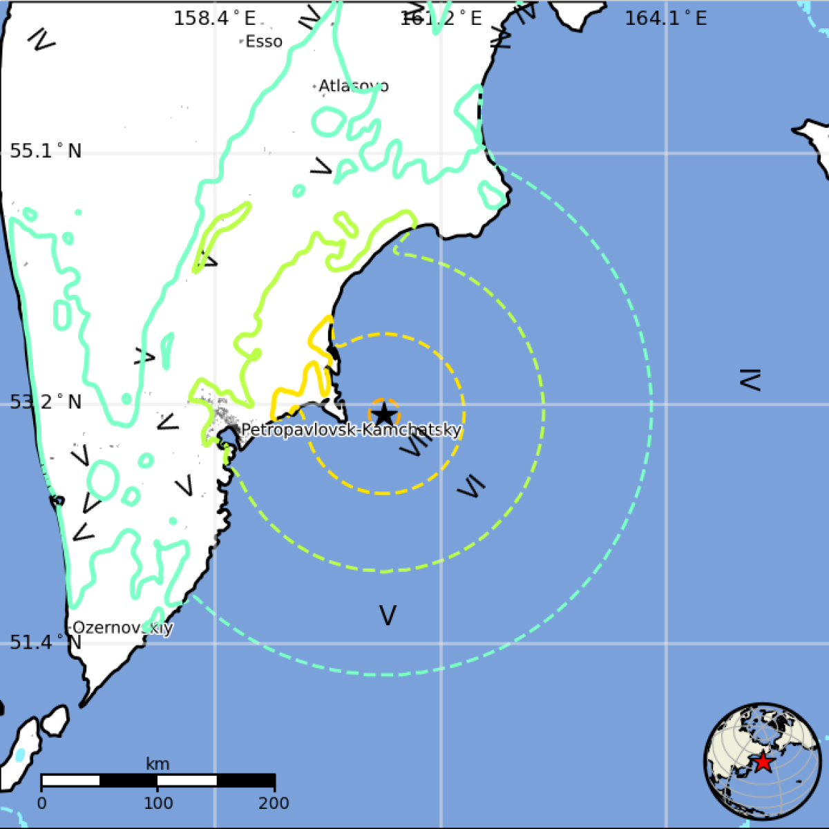
Map from USGS shows how far and how intense Russian earthquake was felt
The U.S. Geological Survey map shows how far the Russian earthquake was felt.
The U.S. Geological Survey map shows how far the Russian earthquake was felt.
USGS
05:06 PM EDT
No tsunami threat for U.S. West Coast, Canadian coast at this time
The National Tsunami Warning Center reports there is no tsunami threat for the U.S. West Coast and the Canadian Pacific coast after the powerful quake in Russia on Thursday.
04:54 PM EDT
Was there an earthquake in the Philippines today? What we know
A couple of small earthquakes were recorded in the Philippines today.
Early Thursday morning, local time, a magnitude 3.3 quake struck near Nasugbu in Batangas, according to local reports.
Later that afternoon, a second, stronger tremor measuring 4.5 was detected in the Philippine Islands region, about 67 kilometers from Barcelona, with a depth of around 18 kilometers.
So far, there have been no reports of major damage or injuries linked to these quakes, and authorities have not issued any tsunami warnings. While residents in nearby areas may have felt some shaking, the impacts appear to have been minor. Officials are continuing to monitor the situation.
04:45 PM EDT
Tsunami advisory in effect for parts of Alaska
🟡Tsunami Advisory is in effect for the Western Aleutians, AK, following a large quake in Eastern Russia. No other U.S. or Canadian continental locations are in an alert.
The M7.8 earthquake occurred at 090mi E Petropavlovsk, Kamchatka 1158PDT Sep 18.https://t.co/npoUHxWBas
— NWS Tsunami Alerts (@NWS_NTWC) September 18, 2025
04:30 PM EDT
What happens when a tsunami hits shore?
Tsunami waves involve movement of the entire water column from surface to sea floor. So while the height of normal waves and tsunami waves is similar in deep ocean water, near shore, tsunami waves slow and swell, reaching heights of 30 feet or more as they crash onto the coast.
About 59 percent of the world’s tsunamis have occurred in the Pacific Ocean, 25 percent in the Mediterranean Sea, 12 percent in the Atlantic Ocean and 4 percent in the Indian Ocean, according to historical records.
An earthquake of more than 9 magnitude off Indonesia’s Sumatra island in 2004 brought death and destruction to countries all around the Indian Ocean, including Indonesia, Thailand, Myanmar, India, Sri Lanka and Africa’s Kenya and Tanzania, killing some 230,000 people in all.
04:21 PM EDT
What is a Tsunami?
The word tsunami comes from the Japanese words for harbor and wave. It is a fast-traveling wave usually triggered by vertical movements of the sea floor as a result of an off-shore earthquake.
Tsunami waves can travel at up to 600 miles per hour, fanning out across oceans from the epicenter of the quake.
04:15 PM EDT
The most powerful earthquakes ever recorded
Earthquakes have reshaped coastlines, triggered deadly tsunamis, and altered history. Here’s a look at some of the most significant quakes ever documented by scientists:
1960 – Valdivia, Chile (Magnitude 9.5): The strongest earthquake ever recorded, it killed over 1,600 people and displaced millions.
1964 – Prince William Sound, Alaska (Magnitude 9.2): Caused massive landslides and a tsunami that reached Hawaii.
2004 – Sumatra-Andaman Islands (Magnitude 9.1): Triggered a devastating tsunami that killed more than 280,000 people.
2011 – Tōhoku, Japan (Magnitude 9.1): Led to the Fukushima nuclear disaster and widespread destruction.
1952 – Kamchatka, Russia (Magnitude 9.0): Generated Pacific-wide tsunami waves, including 30-foot surges in Hawaii.
2010 – Maule, Chile (Magnitude 8.8): Shook central Chile and prompted tsunami alerts across the Pacific.
1906 – Esmeraldas, Ecuador (Magnitude 8.8): Caused a deadly tsunami that reached as far as San Francisco.
1965 – Rat Islands, Alaska (Magnitude 8.7): Produced 35-foot waves but minimal casualties due to its remote location.
1950 – Assam-Tibet (Magnitude 8.6): Destroyed villages and caused deadly landslides in Northeast India.
2012 – Sumatra, Indonesia (Magnitude 8.6): A powerful offshore quake with limited damage but significant seismic impact.
04:12 PM EDT
Map shows where massive 7.8 earthquake struck Russia, about 80 miles east of Petropavlovsk-Kamchatsky