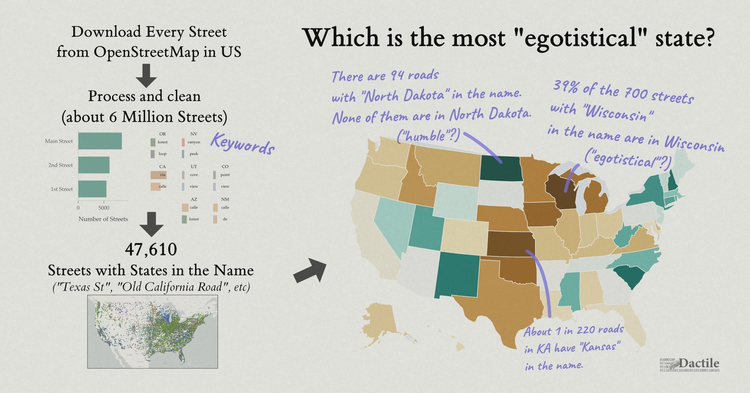
[OC] I found about 47,000 US Streets that include names of US States (eg, “Texas St”). There are ~94 streets that include “North Dakota”, but none of them are in North Dakota. Other states frequently use their own name.
Posted by an-qvfi
![[OC] I found about 47,000 US Streets that include names of US States (eg, "Texas St"). There are ~94 streets that include "North Dakota", but none of them are in North Dakota. Other states frequently use their own name.](https://www.europesays.com/wp-content/uploads/2025/11/baezp6m5vv0g1-1920x1024.jpeg)
[OC] I found about 47,000 US Streets that include names of US States (eg, “Texas St”). There are ~94 streets that include “North Dakota”, but none of them are in North Dakota. Other states frequently use their own name.
Posted by an-qvfi
21 comments
I wrote [an article](https://dactile.net/p/state-street-names) playing around with street map data.
**Abstract:** Street names can reveal what is important to a region. We explore patterns and visualizations of US street names. After looking at broad general trends in names (such as the most common names and keywords), we narrow in on streets that include state names. We estimate there are 47,610 streets with a state name, with Washington in an understandable lead. There are ~94 streets with “North Dakota” in their name, but none of these streets are actually in North Dakota. Meanwhile, about 39% of the ~700 roads with “Wisconsin” in the name are in Wisconsin. There are several conflicting ways to compare usage of state names, making any exact ordering a toy exploration. We discuss these trends and how this analysis was done.
**Data source:** Data comes from [OpenStreetMap](http://openstreetmap.org) (like wikipedia, but for maps). Thanks to all the OSM contributors!
**Tools:** It is mostly done in Python with Polars. Some Rust is used for the data processing the OSM data into a parquet file for Polars. Visualization is mostly done in matplotlib and plotly, with this cover graphic put together in Affinity. The [source code](https://github.com/DNGros/statest-workspace) is available.
Let me know if you have feedback!
All I know is even the smallest of towns seem to have a Main(e) street, so we got that going on when we aren’t running from eldritch horrors that only the most coked up Stephen King could come up with.
Most North Dakota streets are numbers it was part of the system to revamp their rural 911 system. They obviously have streets with word names but if you’re 134 miles out side of city your street will probably be called 134 street
Anyone else have a specific “state streets” area in their town/town you grew up in? In my hometown in Upstate NY in the late 90s/early aughts, “state street kid” was synonymous with the “bad part” of town, whether or not that was fair. I was recently reminded of this while my partner and I were driving around near his Southern California hometown and there was a similar state street area, where I think one house was probably equal to the current value of every state street house in my hometown combined.
Are states more likely to have streets named for nearby states than faraway states? A couple examples I know:
– Old Alabama Road in northern Georgia (I assume this was just “Alabama Road” back in the day)
– Delaware Avenue in Philadelphia (although this is named for the river, not the state) – but Philly’s a bad example because it also has an Oregon Avenue. Nobody knows why.
Edit: I saw you made an interactive map and I think the answer to my question is yes.
Is KA supposed to be a state
The Wisconsin fact doesn’t surprise me at all, seems like every city/town with a population over 5k has a “Wisconsin Ave” as one of their main streets
Does this control for the state’s name also being a geographical feature? For example here in Washington we have Lake Washington, and around the lake are some streets called Lake Washington Boulevard .
As a random tidbit, Michigan Ave. in Chicago certainly counts towards being named Michigan, but it’s interesting because it also intersects Superior, Huron, Ontario, Erie, Ohio, [Grand], and Illinois.
It seems to be both a double reference to both the lake the city sits on and the nearby state.
But this obviously means there may be many Michigan named streets that may be intended to reference the lake, although it also satisfies the state name as well.
Lawrence, KS has almost all the states And they are in order of when the state was ratified.
Edit: It appears more complicated. The names are organized by the history of the Union and the original colonies: streets west of Massachusetts Street are named for states in the order they were admitted to the Union, while streets east of Massachusetts are named for the thirteen original colonies. Some state names were deliberately omitted to exclude pro-slavery states from the city’s geography.
Am I just missing it, or is there no key for the colors?
I imagine (and I wonder if the raw data bears this out) that places the include street names of states (the Western states in particular) are metro areas that expanded quickly, and suddenly needed a whole bunch of related names for new subdivisions. I would suspect all those state names are usually running parallel to each other in one section of the city, either alphabetically or in historical order.
As another poster pointed out, there are probably more places that have the streets of the 13 original colonies than the other states.
And now I’m curious how many (if any) streets are named after the US territories (and DC).
Also, I apologize for the egregious (but functional) use of parentheticals in this post.
I’m wondering if State highways or routes can enter this data. They probably aren’t what you’re looking for, but may have the name of the state in the name.
I don’t understand the colors you’ve used for the states.
Is the color based on count or percentage? brown means more inside the state than outside, green is more outside than in?
States like Tennessee, Maine, New Mexico and Georgia are greyed out, does that mean there are no roads with those names? or that exactly 50% of said roads are in that state? …. or either condition would mark a state grey?
I’m shocked by Washington tbh. I would have thought “Washington” streets are super common across the whole country, considering the guy and all
Hey! If you were as drunk as we are, you’d struggle to name roads too.
This is not the way. Any method that doesn’t yield Texas is flawed.
KA isn’t the state abbreviation for KS.
In Lawrence KS (and several other cities I’m sure) all the roads going north and south are named after states, and I think they’re in the order that they joined the union following the civil war. So, yes, there’s a Kansas street in Lawrence, KS, but there’s also a street for every other state. Even Missouri if you can believe it.
There’s a neighborhood in Nashville where almost all the streets are named for states. Oddly enough, the area is called “the Nations” and not “the States.”
So who gets credit for a Dakota or Washington street?
Comments are closed.