Satellite image of livestock in Sudan misinterpreted as mass graves • FRANCE 24 English
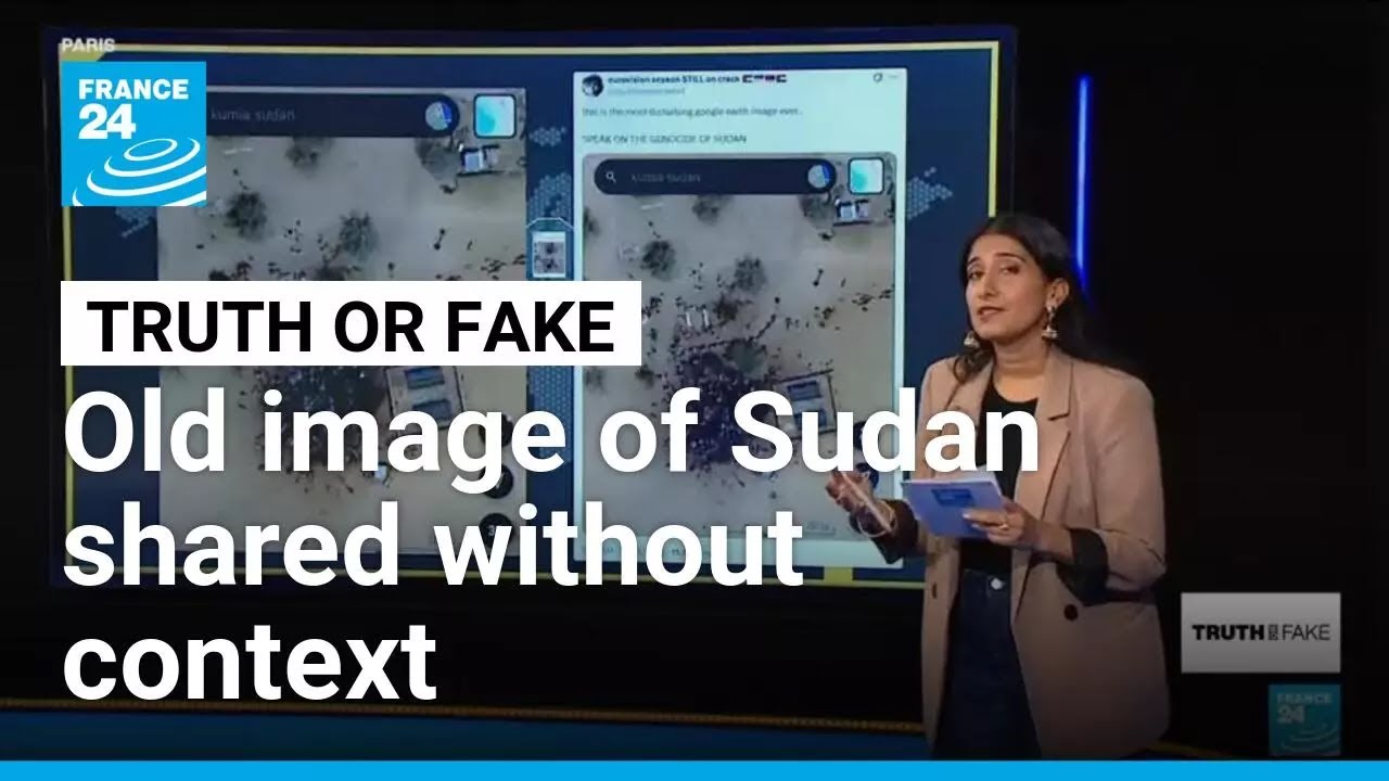
Next is truth or fake with Vica Bahal. She joins me on set. Hi Vicica. Hi John. Vic, we’re going to start this where we’ve just left off the final uh segment talking about the paramilitary rapid support forces and the way that they seized that key Sudin city of Alfasia as well as the mass killings that were reported. Now today we just saw those Yale satellite imagery uh those Yale satellite images. They’ve been studied by researchers and they found evidence consistent with mass graves and blood stains. However, as it’s always important and perhaps more important than ever, these images have to be verified. Why is that? Well, that is the question, John, and I’m going to answer it using uh this photo that has circulated on mass on social media. It’s a screenshot showing the town of Kumio, which is located in uh the southern part of Sudan. We can see a large dark uh patch, a a large dark stain uh in the photo and it’s implied online that this is where dozens of bodies are located given the recent events uh in Sudan. Now, this photo was extremely viral on X. I can’t understate that in any other terms. Um it was posted with this caption, this is the most disturbing Google Earth image ever. Speak on the genocide in Sudan and Jean with 15.7 million views and counting. And that’s just on this post alone. Um, I think it’s fair to say it’s gained a fair amount of traction online. No, I don’t think you would be showing us this if it was authentic. So, the question is, is this authentic? Well, actually, Jean, it is an authentic image of Sudan. There’s no uh AI or manipulation involved uh in this one. It is also located also in the town of Kumia, which is about 300 kilometers from El Fasia. So, the the location is verified. However, uh it is the date that is causing the issue here. And it’s actually the date that shows us uh that this has no connection with recent events in Sudan. And that is because if we compare it to uh Google Earth imagery, we can see the exact same satellite image is visible on Google Earth dating back to the 16th of March 2024. So that’s about a year uh and uh it’s about a year and a half ago. So it is not new in any capacity. In fact, it goes back even further than that. That same image is also visible on Google Earth dating back to March 27th, 2022. So the location checks out it is the date uh it is out of date and is also out of context. So what’s being shared as a pool of blood actually isn’t so. And to explain that further I want to talk about the experts in osent and geoloccation who have been looking into this. Um one of those is Benjamin Strick. He is the director of investigations at the center uh at information resilience. Now, he looked at these images online and he didn’t think he saw them he saw them going viral. He said that that they didn’t go in line with his previous studies into indications of war crimes um through satellite imagery. And he says that what is visible uh in these images is not in fact human bodies. He says it’s in actually a watering hole and these are in fact animals. So, let’s take a listen now to what Benjamin Strick had to say. So, there’s a couple of things that just don’t kind of indicate to me that there’s a mass death occurred. Um, when I looked at this on Google Earth as well, I could also see cattle scattered under the trees taking shade uh very much further away from this. We’ve also got lots of concentrations of these things around the darker spots which may indicate concentrations around uh more wetter patches like like water troughs uh outside of looking at all of the other factors is uh this is just a concentration of of livestock. So there you have it. uh that is livestock uh and cattle and a watering hole directly from the expert uh himself, not human bodies and not recent images, animals, not humans. But nonetheless, Vica, there are very real satellite images coming out of Alasia that we saw from Yale released today and that suggests atrocities. That is correct. Uh so as we mentioned earlier the Yale’s re humanitarian research lab just released their analysis of satellite imagery and if we take a closer look at those images uh we can indeed see they have made it very clear they’ve uh described in detail where they’ve seen the new disturbed earth new trenching the disposal of bodies visible in their report in their images and going back to your previous question about how important it is to fact check well I think it we can see it here in these examples that I’ve shown that there is indications and study by the experts saying that something is happening and seeing one example online going viral doesn’t necessarily mean that it’s not and it shouldn’t cloud your judgment or color your judgment to think that it might not be happening and that’s something we spoke about with our expert Benjamin Strick as well and his main takeaway is that he’s actually seen more views of the of the of the photo that gone viral that wasn’t verified and wasn’t real. Um so let’s take a listen to what he had to say about that. What’s even more unfortunate is that out of all of the things that were to come out from Saddan over the past two weeks, this, in my opinion, had almost the most uh uh views. So, for me, that’s a big concern because it means that people can say, well, maybe it’s fake. The other footage of human rights abuses, maybe the footage of genocide isn’t real, and it is. Uh, so it’s very concerning this. So Jean, I think that is a a great point. We’ll just leave it there from the from the mouth of our experts. And that just shows you why you have to get the facts right because they could invariably dilute what is important and what is true if uh people take them the wrong way. Vered Bahal, thank you so much. Truth or fake segment
Following reported mass killings at the end of October by Sudan’s paramilitary Rapid Support Forces in the besieged city of El-Fasher, internet users shared a screenshot from Google Earth purporting to show the site of a massacre. But according to satellite image analysts, this image is dated and in fact depicts livestock. We spoke directly to the expert involved in the fact-check in this episode of Truth or Fake.
#sudan #elfasher #massgraves
Read more about this story in our article: https://f24.my/BXv6.y
🔔 Subscribe to France 24 now: https://f24.my/YTen
🔴 LIVE – Watch FRANCE 24 English 24/7 here: https://f24.my/YTliveEN
🌍 Read the latest International News and Top Stories: https://www.france24.com/en/
Like us on Facebook: https://f24.my/FBen
Follow us on X: https://f24.my/Xen
Bluesky: https://f24.my/BSen and Threads: https://f24.my/THen
Browse the news in pictures on Instagram: https://f24.my/IGen
Discover our TikTok videos: https://f24.my/TKen
Get the latest top stories on Telegram: https://f24.my/TGen
9 comments
So it isnt but only the coordinates are wrong
I thought this was an image of live stock. And had something to do with water. I didnt watch the full news article but yeah
Whatever let it be…War is not good at all and should be stopped
DEBUNKED!
The Fact the Map is now Blurred an you can clearly see they are tampering with it on Google maps I’m not Buying this Clip…..
What is UN doing to prevent this evil attacks?? Why are innocent people dying in Sudan??? 🇸🇩 😢😢
And by “live stock” they mean human bodies. So sad! So very sad!
It took her forever to get to the point
Of course its the french thats making this
Comments are closed.