Just days after a large swath of southern Alberta was hit with its first big snowfall of the winter, there’s another storm system bearing down on the province.

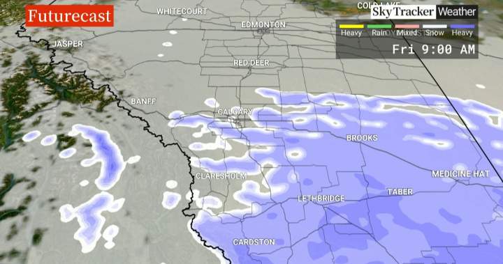
Environment Canada is forecasting the snow to start falling Thursday afternoon in the form of flurries for Edmonton and Calgary, while more southerly communities such as Lethbridge and Medicine Hat are expected to see heavier snowfall.
“As we progress through Thursday afternoon and into the evening hours, snow moves up from the southwest and does reach the Calgary area right around the late supper hour and into the overnight, and eventually will cover most of the region,” said Global News weather specialist Phil Darlington.
“It does taper off Friday morning, so the commute for Thursday evening (will be) not so bad, but Friday morning you are going to want to take your time,” added Darlington.
Some areas of the southern foothills and extreme southerly parts of the province could get up to 25 cm by the time the snow starts to taper off Friday night.
The heaviest snow is expected to fall over the extreme southerly parts of Alberta where between 15 and 25 centimetres of snow is forecast for Lethbridge and into the foothills.
Global News
The temperatures are also expected to plunge, with the daytime high forecast to be around -10 C on Friday and Saturday, well below the normal daytime high of around zero at this time of year.

Get the day’s top news, political, economic, and current affairs headlines, delivered to your inbox once a day.
Overnight temperatures in Lethbridge and Medicine Hat could also dip to near -20 C, about 10 degrees below normal.
“For this coming weekend, we’re looking at the temperatures dropping right across the province, but then into next week we’re getting a little bit of a rebound that we weren’t originally forecasting, and then we’re going to drop again into the following weeks — you know, 10 to 15 degrees below normal temperatures,” said Environment Canada meteorologist, Alysa Pederson.
The sudden arrival of winter is being blamed on the ‘polar vortex‘, a large area of low pressure and cold air surrounding the north pole that is sending abnormally cold and stormy weather into the more populated areas of North America..
“The polar vortex is something that always exists (but) sometimes we have a weakening of the jet stream and that’s essentially what creates that vortex,” said Pederson.
“When that jet stream weakens, that cold is able to slump south, impacting parts of southern Canada or even in some cases as far south as Florida.”
Over the longer range, Environment Canada is predicting a weak La Nina to develop.
“So La Nina for our area typically means cooler temperatures (and) snowier patterns for the winter months, so December, January and February — so that’s essentially what our longer-range forecasts are indicating is on average cooler than normal,” said Pederson.
“So we could see a couple of days at least in the month of December where we do hit daytime highs of -20.
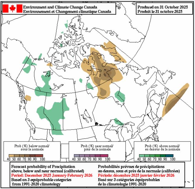
Envrionment Canada’s latest seasonal forecast predicts higher-than-normal snowfall across much of Alberta this winter.
Source: Environment Canada
The seasonal forecast from Environment Canada also predicts higher-than-normal snowfall amounts over much of Alberta for the months of December, January and February.

1:54
Polar vortex set to bring early winter blast to much of Canada next week
© 2025 Global News, a division of Corus Entertainment Inc.