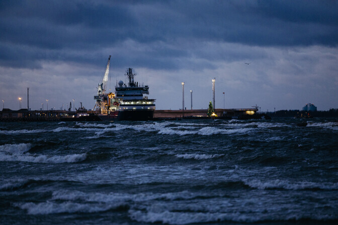
The state agency said the strong winds will break trees, cause power outages and disrupt maritime traffic. The worst weather is expected to hit western Estonia.
A Level 3 “Red” warning has been issued, the most severe category, for Saaremaa and Hiiumaa.
A red warning means “major damage and accidents are likely,” and that health and well-being are at risk. Members of the public should keep themselves updated on the weather situation and risks, and follow orders and any advice given by authorities, including extraordinary measures.
Harju County, which includes Tallinn, as well as Lääne County and Pärnu County, have been issued Level 2 “Orange” warnings (“dangerous”). These forecast “unusual meteorological phenomena” and also advise the public to keep up to date on conditions and to follow official announcements.
The rest of Estonia is on a Level 3 (“Yellow”) warning at the time of writing, which states that conditions are “potentially dangerous.”
Updates to weather warnings are available here.
Elektrilevi reports over 1,800 power outages
As of 6:39 p.m. on Saturday, around 1,861 power outages were reported nationwide by grid operator Elektrilevi Whereas at around 3.30 p.m. earlier the highest number of outages had been posted in Harju County, including Tallinn, by the time of writing Saaremaa, on red alert since the morning, was the most heavily affected, with 777 power cuts. Neighboring Hiiumaa, also on the highest state of warning, was next with 264 outages, followed by 235 in Lääne County. 203 customers in Lääne-Viru County were without power at the same time, while Pärnu County (194 outages) and Harju County (188) were the other significantly affected regions.
“The Elektrilevi control center already began preparatory actions on Friday, during which we increased the number of network service managers in storm-affected areas both at night and during the day. All electrician crews as well as a crisis reserve made up of Elektrilevi employees are on standby. We also urge people to follow all warnings and, during dangerous weather, stay at home safely and in good health, and to stock up on drinking water and food and charge batteries,” said Mihkel Härm, Elektrilevi board chair.
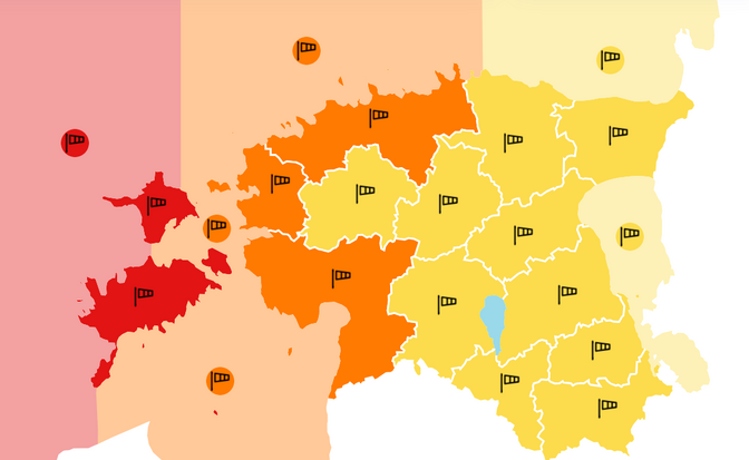 The storm warnings issued for Estonia as of the morning of Saturday, December 27, 2025. Source: Environment Agency
Elektrilevi asks all affected to report power outages via the MARU app, which enables rapid information exchange between customers and Elektrilevi in the event of electrical faults.
More information on the app and the outages map updated in real time is available from Elektrilevi’s website here.
Rescue Board deputy chair going outside if in the most storm-affected areas ‘the worst idea you can have’
Viktor Saaremets, Deputy Director General of the Rescue Board (Päästeamet) gave similar advice. “Those who live in storm-affected areas should make sure that items outdoors do not get blown away. If the storm causes any damage, do not start clearing it up until the storm has subsided. If there are power outages, also monitor Elektrilevi’s outage maps, and if you are not shown on the map, it is worth notifying Elektrilevi that you, too, have experienced an outage. Naturally, the main thing people should do is to stock up on essential items needed at home in the event of a power outage: Something that provides light, something that provides warmth, and food and drink. And once again: during a storm, if you are in an area where the storm is raging, going outside is the worst idea you can have,” Saaremets said.
Ferry traffic between the mainland and Hiiumaa suspended
The storm has disrupted ferry connections between Hiiumaa and the mainland.
Saturday’s sailings on the Rohuküla–Heltermaa route were canceled due to weather. The 2:30 p.m. sailing from Heltermaa (Hiiumaa) went ahead, but Sunday morning’s sailings before 10:00 a.m. have also been cancelled. Information about the 10:00 a.m. departure from Rohuküla will be provided on Sunday morning at around 8:30 a.m.
The shorter Saaremaa route was still working at the time of writing, but passengers are advised to follow up-to-date information on departures.
The website of TS Laevad, which operates the ferries to the two main islands, is here. Links to the other islands may be affected too.
Winds picked up from Friday, gathering in strength from Saturday morning
Rising northwesterly wind in gusts up to 32 meters per second in coastal areas in the northwest were forecast from Saturday morning and through the day. Even inland, northwesterly gusts are forecast to reach 20 meters per second.
There will also be showers of rain and sleet, and snow in the evening.
Friday was mostly clear, although the northwesterlies began to intensify, while low temperatures inland created slippery roads. The winds died down somewhat in the evening only to pick up again Saturday.
Sunday’s weather forecast
The storm will continue into Sunday, with nighttime gusts reaching 20 meters per second inland, 30 along the coast, and possibly more near the sea. Cold air will move in, and temperatures will remain above freezing only along the coast during the day.
The new week will begin with subzero temperatures and continued strong winds. Snow and sleet will fall from time to time. There will be patchy snow cover in Western Estonia, but in the east, a more substantial layer of snow will accumulate.
Editor’s note: This article was updated to include the storm warnings issued for Saturday, December 27, outage figures from Elektrilevi and information about ferries to the islands, as well as a gallery of storm impact in Tallinn.
—
Follow ERR News on Facebook and Twitter and never miss an update!