From reproductive rights to climate change to Big Tech, The Independent is on the ground when the story is developing. Whether it’s investigating the financials of Elon Musk’s pro-Trump PAC or producing our latest documentary, ‘The A Word’, which shines a light on the American women fighting for reproductive rights, we know how important it is to parse out the facts from the messaging.
At such a critical moment in US history, we need reporters on the ground. Your donation allows us to keep sending journalists to speak to both sides of the story.
The Independent is trusted by Americans across the entire political spectrum. And unlike many other quality news outlets, we choose not to lock Americans out of our reporting and analysis with paywalls. We believe quality journalism should be available to everyone, paid for by those who can afford it.
Your support makes all the difference.
Read more
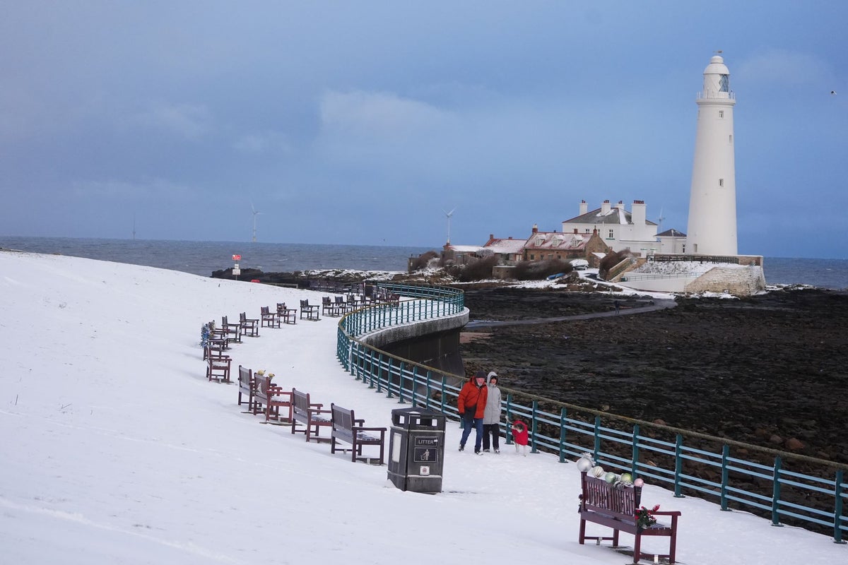
The Met Office has issued fresh weather warnings as Storm Goretti is set to bring heavy snow to the UK.
Storm Goretti, named by French meteorological service Meteo-France, is the first storm of the year and is likely to cause significant travel disruption in Britain, although France will be the most severely impacted.
The UK Met Office has now issued two amber weather warnings for Thursday evening ahead of the storm, including an amber wind warning for 80 to 90mph winds in Cornwall, meaning there will be a “danger to life” from large waves and debris.
Another amber warning will bring 10 to 15cm of snow, with the potential for 20 to 30cm in some locations mainly on hills, especially in Wales and the Peak District.
Four yellow weather warnings for snow and ice cover other parts of the UK on Thursday, including Scotland, Northern Ireland and the Midlands, two more for rain in eastern England and Wales, and another for wind in the South West.
open image in gallery
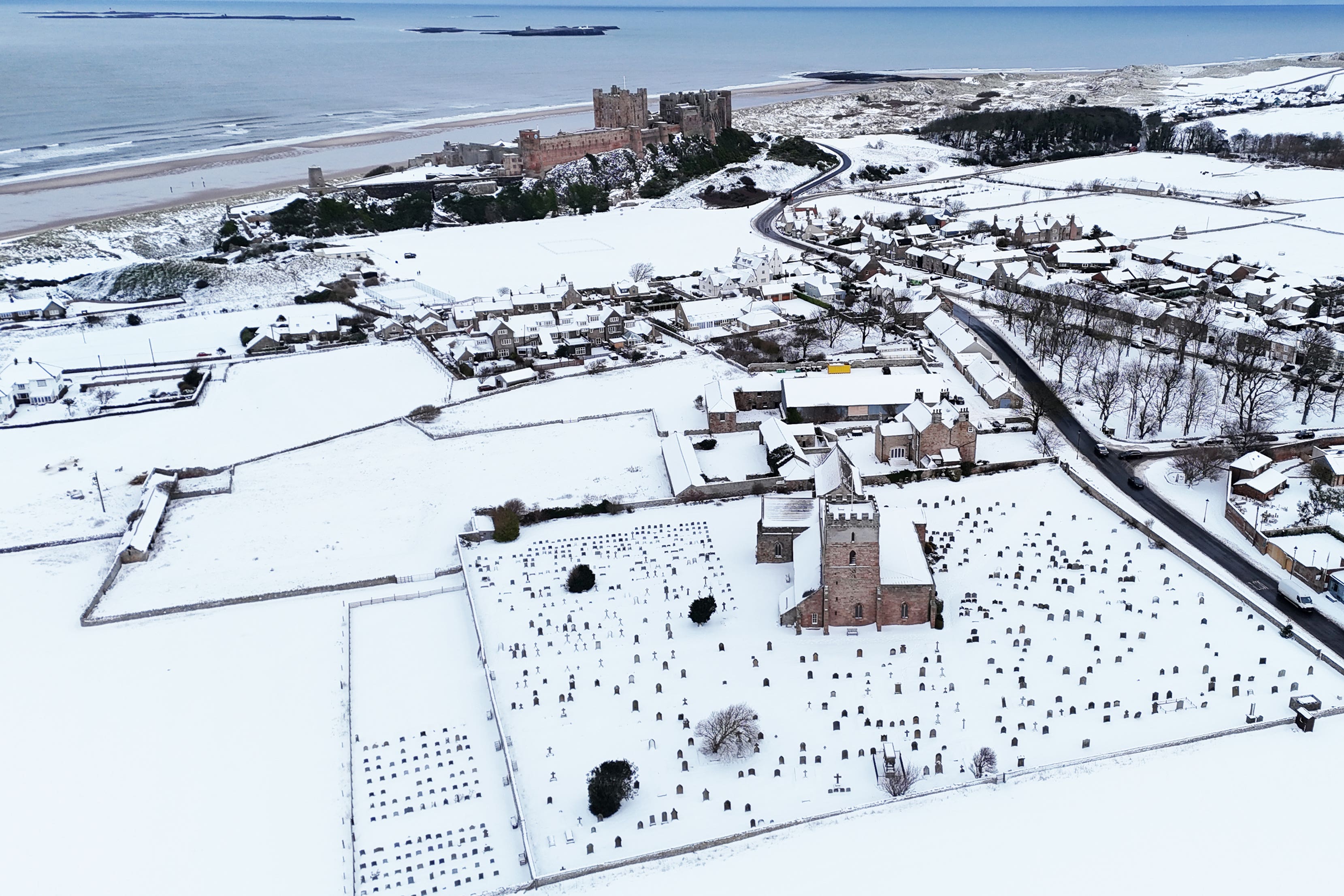
Bamburgh Castle surrounded by snow in Bamburgh, Northumberland (PA)
Mass cancellations to and from Amsterdam Schiphol airport are continuing for a sixth day due to snow and ice, with flights between the Dutch hub and UK airports on KLM cancelled. KLM grounded 600 flights to and from its hub on Wednesday.
British Airways has cancelled 10 flights linking Heathrow with Amsterdam, and a round-trip from London City airport.
Aberdeenshire Council also declared a “major incident” as ongoing snow continues to cause travel disruptions and school closures.
Wednesday’s weather warnings
open image in gallery
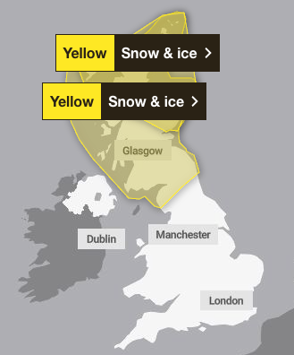
Snow and ice warnings remain in place on Wednesday (Met Office)
Joint snow and ice warnings remain in place in the very north of Scotland all day on Wednesday, with another coming into force for the rest of Scotland from 10pm.
Icy patches on untreated wet surfaces are expected, which could lead to minor disruption.
Thursday’s weather warnings
open image in gallery
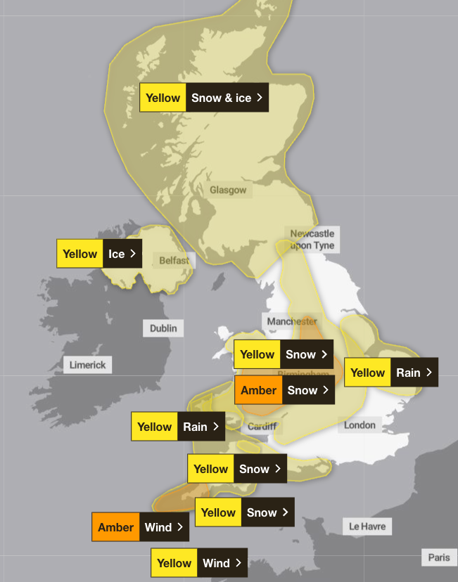
Nine weather warnings are in place across the UK on Thursday (Met Office)
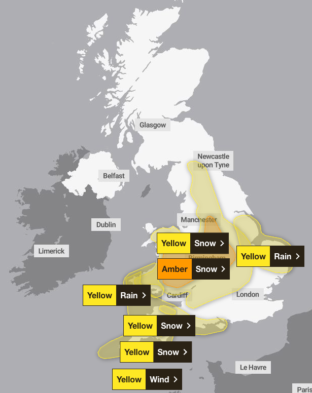
The Met Office has issued two amber and seven yellow weather warnings across the country on Thursday.
Northern Ireland will see a yellow ice warning in place from midnight on Wednesday to 10am on Thursday, with temperatures expected to fall rapidly and bring an ice risk overnight.
Snow and ice are likely to cause further disruption overnight on Wednesday through to Thursday morning for Scotland, as the Met Office has extended a yellow weather warning until 12pm.
A yellow wind warning is in place across the southwest of England and Wales as a deep area of low pressure will move across the south of the UK during Thursday and into Friday, bringing a mixture of rain, snow and strong winds. The warning is in place from 3pm until midnight.
Two yellow weather warnings for snow will be in place across Wales, the southeast and west of England, and the Midlands on Thursday from 5pm and 8pm. Storm Goretti will likely bring heavy snow over higher ground in south Wales. In some areas, 5 to 10cm of snow may settle with the potential for up to 20cm in some locations, especially over higher ground. Strong winds may lead to some drifting of snow.
Later in the evening, an amber warning for heavy snow from 8pm will cover parts of Wales, the Midlands and South Yorkshire.
The snowfall, brought by Storm Goretti, will mean trains and planes could be delayed or cancelled, rural communities may cut off, and power cuts or disruption to mobile signal are likely, forecasters said. The warning stretches from Sheffield in the north, down to Leicester, across much of the West Midlands and into Wales.
An amber wind weather warning is in place over Cornwall and the Isles of Scilly on Thursday from 5pm to 11pm as the forecaster warned there may be a “danger to life” from large waves and debris being thrown onto beachfront roads and properties.
Storm Goretti may bring a short period of exceptionally strong northwesterly winds to the Isles of Scilly and parts of Cornwall on Thursday evening, with peak gusts potentially of 80 to 90mph in exposed areas.
Two yellow weather warnings for rain are in place from midday in south Wales and eastern England from 6pm.
Friday’s weather warnings
open image in gallery
Weather warnings for Friday updated (Met Office)
Storm Goretti is set to continue into Friday with the amber “danger to life” warning for snow still in place in the Midlands, Wales and the South West until 9am.
Five other yellow weather warnings are also in place. A wind warning in the South West and Wales ends at 6am. One for rain in south Wales ends at 10am, but another for rain in the East will not end until 9pm.
A yellow warning for snow in the South West ends at 9am and another across large areas of the UK, including the Midlands, Wales, the North East and the North West, will be over by midday.
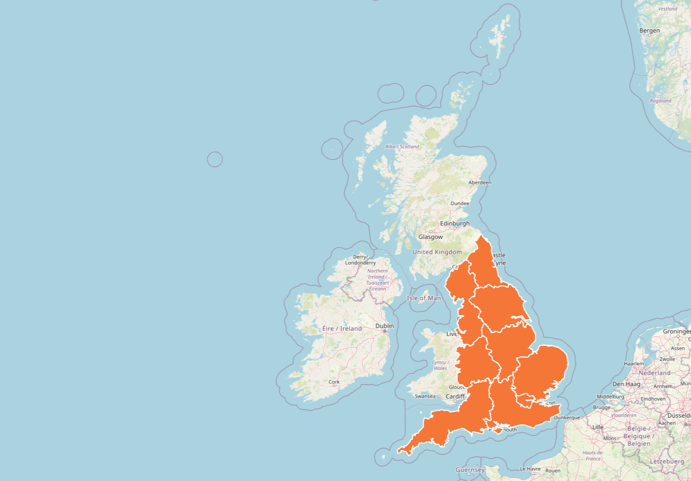
Cold health alert extended until Friday
The UK Health Security Agency (UKHSA) has issued amber cold health alerts for all of England until Friday at 10am, warning there could be significant impacts across health and social care services, including a rise in deaths, particularly among those aged 65 and over or with health conditions.
Dr Agostinho Sousa, head of extreme events and health protection at UKHSA, said: “As the colder weather sets in, it is vital to check in on friends, family and neighbours that are most vulnerable.
“The forecast temperatures can have a serious impact on the health of some people, leading to increased risk of heart attacks, strokes and chest infections, particularly for individuals over the age of 65 and those with pre-existing health conditions.”
open image in gallery
Amber cold weather health alerts remain in place across the UK (UKHSA)
Matthew Lehnert, chief meteorologist at the Met Office, said: “As we begin the first full working week of the year, we face a range of winter weather hazards with snow showers and ice.
“In the north of Scotland, snow showers are expected to become more frequent on Sunday night, with some locations within the amber warning areas seeing a further 20 to 30cm accumulate by Monday morning.
“Elsewhere in the UK, snow showers, ice and frost are expected at times, but milder air will make attempts to spread eastward from Tuesday. This will mean rain becomes more likely in the south, but there is also the possibility of more organised snow along the boundary of the mild and cold air masses. Strong winds could also be a feature later in the week.
Travel disruption
Hundreds of schools in northern Scotland will remain closed for a third day as much of the country braces itself for further snow and icy conditions. Some rural areas have been completely cut off, and transport is severely affected by the weather.
Pupils in the Highlands were due to return from the festive break on Wednesday, but many will have an extra day off with more than 120 schools shut due to the weather conditions.

open image in gallery
A string of snow and ice warnings is in place across the UK as the Met Office has warned that cold conditions would bring a range of wintry hazards for the next few days (PA)
The snowy conditions disrupted road, air and rail travel across the country – with some train lines shut after heavy snow drifted onto the tracks.
London North Eastern Railway (LNER) has listed 24 travel disruptions as heavy snow continues to cause disruption to its services across northern Scotland.
While Network Rail advised that the line north of Edinburgh has reopened, LNER said “customers should NOT TRAVEL between Edinburgh and Aberdeen” as trains may be “delayed, cancelled or altered at short notice and/or experience overcrowding”.
Police Scotland said the impact of the snow is likely to be felt over the next few days in the north and northeast of Scotland, urging people to follow travel advice.
Assistant chief constable Alan Waddell said: “Local resilience partnerships are continuing to meet to co-ordinate and deliver the response to disruption experienced by communities in the north and northeast of Scotland following heavy snowfall over the weekend.
“We have been working closely with resilience partners across local authorities, other emergency service partners, transport partners, NHS and health and social care partnerships, and other local organisations to support communities affected by adverse weather and keep public services open where possible.
“Some services may be impacted by adverse weather and I would encourage the public to check on neighbours or relatives, if they are able to do so safely.”