Published on
January 8, 2026
By: Paramita Sarkar

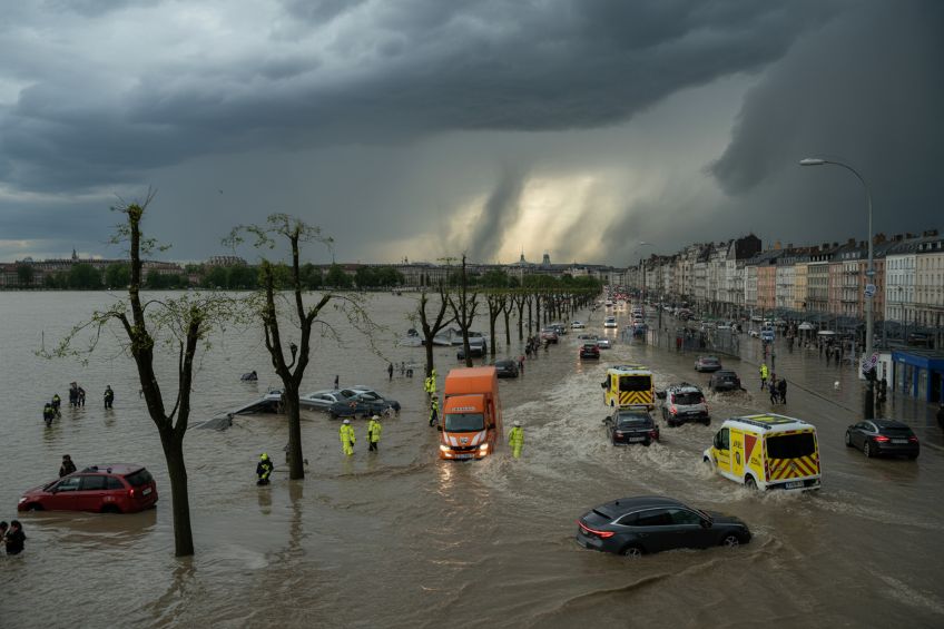
Storm Goretti, the first major storm to be named in 2026, is a “multi-hazard event” that has already wreaked havoc across Western Europe. Affecting regions from the United Kingdom (UK) to France, the Netherlands, and Belgium, this storm, fueled by a combination of snow, ice, high winds, and freezing temperatures, is creating a travel nightmare, disrupting air, rail, and road transport systems. The event has prompted official weather warnings and advisories from meteorological agencies in each country, with the situation expected to worsen in the coming days.
The Storm’s Journey: Where Has Storm Goretti Hit Hardest?
Storm Goretti made its way across Europe on January 7, 2026, and its effects were immediately felt in the UK, France, Netherlands, and Belgium. On Thursday, January 8, the storm continued to create dangerous weather conditions, causing significant disruptions. The official meteorological agencies of the UK (Met Office), France (Météo-France), the Netherlands (KNMI), and Belgium (RMI) have all issued high-level alerts for these regions.
Official Government Warnings: How Are Authorities Responding?United Kingdom (Met Office):
The UK Met Office classified Storm Goretti as a “multi-hazard event,” with warnings in place for snow, wind, and rain. These warnings have affected several regions across the country, including Wales, the Midlands, and South Yorkshire. An Amber Snow Warning is in effect from 8:00 PM Thursday to 9:00 AM Friday, advising that 5-10 cm of snow will accumulate widely, with up to 30 cm on higher ground. Areas affected by this warning should be prepared for disruption to travel and power services. The Amber Wind Warning covers Cornwall and the Isles of Scilly, where winds of 80–90 mph are expected, posing a “danger to life” due to the risk of flying debris. This warning is active from 5:00 PM Thursday to 11:00 PM Thursday, with some coastal areas expecting gusts reaching these speeds. Meanwhile, a Yellow Warning has been issued for parts of southern England and Wales, where rain and snow could cause hazardous travel conditions. Additionally, Northern Ireland and parts of Scotland are also under Yellow Warnings for ice, making road conditions extremely slippery and dangerous.
France (Météo-France):
Météo-France, which named Storm Goretti, is issuing several key warnings as the storm progresses. One of the most critical alerts involves wind conditions. The agency has issued a Yellow Alert for wind starting at 8:00 PM Thursday for Paris and the surrounding Île-de-France regions. Winds are expected to reach speeds of 80–95 km/h in the capital, with even higher gusts up to 100 km/h in northern parts of the country. Coastal areas, particularly along the Normandy coast, are under high-level alerts due to the likelihood of winds reaching up to 140 km/h. This poses a significant threat to infrastructure and people’s safety, particularly along exposed coastal areas. French authorities are advising residents to limit travel and exercise caution, especially when traveling on the night of Thursday and into Friday morning, as falling trees and debris could pose significant risks to life and property.
The Netherlands (KNMI):
The Royal Netherlands Meteorological Institute (KNMI) has extended Code Yellow warnings nationwide for snow and ice. The storm continues to bring heavy snowfall to the northern regions of the Netherlands, with strong winds contributing to snowdrifts that are making many roads impassable. The conditions are expected to persist through Thursday night and into Friday, creating hazardous travel conditions for commuters. As temperatures remain low, the threat of slippery roads is heightened across the entire country. Freezing wet surfaces are expected to continue throughout the weekend, with temperatures struggling to rise above freezing. The Dutch authorities have urged people to stay off the roads unless absolutely necessary, and have advised travelers to check KNMI weather updates regularly to stay informed of rapidly changing conditions.
Belgium (RMI):
The Royal Meteorological Institute (RMI) in Belgium has issued Yellow Alerts for ice and snow throughout Thursday. The RMI has forecast that temperatures will hover around 2°C on Thursday, but by Sunday evening, temperatures are expected to plummet to -5°C, creating persistent freezing conditions. These conditions will make roads particularly hazardous, especially in secondary roads and areas that have not been treated for ice. The RMI has specifically warned that ice and snow left behind from earlier in the storm could create dangerous conditions for travelers, urging caution during the day and throughout the weekend.
Travel Disruptions: How Is Storm Goretti Impacting Transportation?
The most severe disruptions from Storm Goretti have occurred across air, rail, and road transport systems in the affected countries. The storm’s intensity has not only caused extensive delays and cancellations but also created conditions that are dangerous for travelers.
Air Travel:
Airports across Europe, including those in Paris, Amsterdam, Brussels, and London, have been hit hard by the storm. The French Civil Aviation Authority (DGAC) issued significant flight reductions, with Charles de Gaulle (CDG) and Orly airports experiencing major disruptions. Approximately 40% of flights at CDG were canceled on Wednesday, with a similar proportion of flights at Orly grounded due to adverse weather conditions. Passengers are strongly advised to check flight statuses online before traveling. At Amsterdam Schiphol, one of Europe’s busiest airports, over 700 flights were canceled due to a shortage of de-icing fluid, which severely hampered the airport’s ability to clear aircraft for takeoff. This problem was compounded by the freezing temperatures and snow, with conditions expected to worsen throughout the evening. Brussels Airport has also been experiencing delays due to snow and freezing fog. Although conditions are slightly improving, the airport continues to operate under winter protocols, with ongoing runway clearing and aircraft de-icing required for each departure. Travelers are urged to allow extra time for their journeys and stay updated through real-time updates on the airport’s website.
Rail Travel:
Eurostar, the high-speed rail service connecting London, Paris, and Brussels, has issued travel alerts, citing adverse weather conditions affecting the network. Multiple Eurostar services between London St Pancras, Paris Gare du Nord, and Brussels have been canceled or severely delayed. The weather conditions in the Netherlands have worsened, particularly affecting services beyond Brussels to Amsterdam and Rotterdam, where travel has been suspended due to the deteriorating conditions on the Dutch rail network. National Rail services in the UK have also been heavily impacted, with operators issuing Amber and Yellow weather warnings for snow, ice, and wind. A Yellow Warning for snow has been issued for regions in the Midlands and Wales, with up to 30 cm of snow expected in certain areas, while other regions like Cornwall face high wind warnings of up to 90 mph. Travelers are advised to check National Rail Enquiries for the latest updates and disruptions before embarking on any journeys.
Road Travel:
Road travel in the UK, France, Belgium, and the Netherlands has become dangerous as snow, ice, and freezing conditions continue to affect traffic. The UK’s National Highways has issued multiple warnings for hazardous driving conditions, urging people to avoid travel in areas with heavy snow and high winds. Additionally, the Met Office has warned of the risks of flying debris from trees and other structures, particularly in the Southwest and coastal areas. In France, local authorities have advised caution on secondary roads, particularly in rural areas where the storm’s impact has been most severe. Similarly, road conditions in Belgium are being monitored closely, with several routes expected to be affected by snow and ice. Authorities in both countries are advising drivers to travel with extreme caution and to avoid non-essential journeys if possible.
The Storm’s Worsening Impact: What’s Next?
As Storm Goretti moves forward, the situation is likely to deteriorate. The UK Met Office has warned of heavy snow and wind gusts in the coming hours, with conditions set to worsen by Thursday night and Friday morning. Areas in Wales, the Midlands, and South Yorkshire are expected to face additional snowfalls overnight, while the Southwest of the UK is bracing for violent winds that could lead to significant property damage and injuries.
In France, Météo-France continues to monitor the storm’s rapid progression. The Yellow Wind Alert issued for Paris is likely to escalate in severity as the low-pressure system intensifies. Additionally, authorities are concerned about the possibility of flooding in coastal regions, particularly in Normandy and Brittany, where the storm could coincide with high tides.
For the Netherlands and Belgium, the situation is expected to remain dire throughout the weekend, with temperatures remaining well below freezing. The authorities have urged all citizens to prepare for prolonged icy conditions, which will likely cause road closures and further disruptions to transport systems.
Conclusion: Stay Safe and Stay Informed
Storm Goretti’s wrath continues to impact millions of people across Western Europe. With official warnings still in effect and the storm expected to last through the weekend, travelers are urged to stay updated with the latest weather advisories from their local meteorological agencies. Whether you’re traveling by air, rail, or road, caution is advised, as conditions are set to worsen, and additional disruptions are likely.
Stay safe and be prepared:Monitor updates from official agencies such as the Met Office (UK), Météo-France, KNMI (Netherlands), and RMI (Belgium).Avoid non-essential travel, especially in areas with heavy snow and ice.Stay informed about flight, train, and road delays via official channels.