
Aug. 22, 11:50 p.m. update
The Hawk Fire is now being mapped at 10,522 acres and remains 0% contained.
Approximately 400 personnel are currently working on the incident, with resources coming together from local, state and federal agencies, including ground crews and air resources.
Truckee Meadows Fire and Rescue says the fire experienced significant growth throughout the day, fueled by strong, gusty winds, low humidity and dry vegetation.
Firefighters will continue working through the evening to protect communities, structures and critical infrastructure.
The Nevada National Guard says they’re sending one CH-47 Chinook and one UH-60 Black Hawk aircrews in support of aerial firefighting efforts on the Hawk Fire.
Additionally, 60 Nevada National Guard Response Force personnel have been called to assist local law enforcement in safeguarding evacuated neighborhoods.
Evacuations have expanded to the south, impacting the Somersett community, including areas north of Somersett Parkway to Robb Drive, as well as neighborhoods in northwest Reno. Rancho San Rafael Park is closed.
The most current Washoe County map is available at the Perimeter Map website.


Perimeter Map
An evacuation center has been set up at the Reno-Sparks Convention Center, 4590 South Virginia Street, Reno.
Small animals can go to Washoe County Regional Animal Services on Longley Lane. Large animals can be taken to the Ironwood Event Center, at 5600 Whiskey Springs Road.
The Hawk fire has also led to evacuation warnings in Sierra County, California. See the latest California evacuation warnings on the Genesys Map.
______________________________________________________________
Aug. 22, 9:30 p.m. update
Governor Joe Lombardo has declared a state of emergency in Washoe County as the Hawk fire continues to spread.
Under the declaration, all state agencies are directed to work through the Nevada Emergency Operations Center to supplement local efforts.
The Hawk Fire is now being mapped at 10,522 acres and remains 0% contained.
The most current map is available at the Perimeter Map website.
The evacuation site at the Evelyn Mount Northeast Community Center is now at capacity and a new evacuation site has been set up at Hall 4 of the Reno-Sparks Convention Center, 4590 South Virginia Street, Reno.
_______________________________________________________________
Aug. 22, 9:00 p.m. update
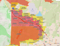
The Hawk Fire is now being mapped at 10,522 acres and remains 0% contained.
According to NDOT, U.S. 395 northbound is closed between Parr Blvd and Bordertown. U.S. 395 southbound freeway ramps are open between Stead Blvd and Reno for evacuations.
New Evacuation Warnings have been issued in the Lemmon Valley and Silver Knolls area.
The most current map is available at the Perimeter Map website.
Perimeter Map
EVACUATION CENTER
The evacuation site at the Evelyn Mount Northeast Community Center is now full.
The new evacuation site is located at Hall 4 of the Reno-Sparks Convention Center, 4590 South Virginia Street, Reno.
DISCOUNTED ROOM RATES:
If you are being evacuated, the Silver Legacy, Eldorado and Circus Circus Reno are offering a $59 room rate with no resort fee.
Call 1-800-223-7277 or book online with code SCLOC26.
J Resort is also offering a $59 discounted rate with no resort free. Use the code HAWK26 when booking online.
The Nugget is Sparks is also offering a $49 room rate for evacuees.
LARGE ANIMALS
According to Washoe County, the Reno-Sparks Livestock Event Center is NOT an evacuation center for animals. An event this weekend means there is currently no room.
We will update this story when a location has been identified.
Mayor Hilary Schieve has released a statement as the firefight continues:
“My heart goes out to anyone in our community who has been impacted by the dangerous and fast-moving Hawk Fire. Our firefighters and first responders are heroically fighting the fire and the high winds to save lives, homes, businesses, livestock and pets.
If you have been told to evacuate, please don’t wait! Structures have already been burned in this fire and your life is more important than a building. Evacuating before the fire arrives also allows our firefighters to focus their efforts on battling the blaze.
I encourage our community to please keep our firefighters and first responders in your prayers and to open your hearts, homes and businesses to the people who have had to evacuate.
The City of Reno staff and regional partners will keep you updated on the information you need to know through local news media, social media, perimetermap.com and emergencywashoe.com.”
_______________________________________________________________
Aug. 22, 7:45 p.m. update:
The Hawk Fire has grown to 8,020 acres according to the latest estimate from fire officials.
Evacuation orders and warnings continue to expand.
The most current map is available at the Perimeter Map website.
________________________________________________________
Aug. 22, 7:00 p.m. update:
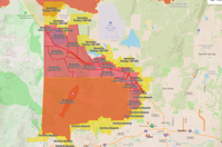
The evacuation orders and warnings are now expanding rapidly.
New evacuations are in effect for all communities on the north side of US 395 that border the highway.
The most current map is available at the Perimeter Map website.
Perimeter Map
Fire officials have not updated the number of acres burned. The Hawk Fire has burned an estimated 2,500 acres.
U.S. 395 remains closed between Parr Blvd and Red Rock Rd.
_______________________________________________________________
Aug. 22, 6:30 p.m. update:
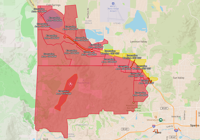
Some evacuation warnings have been changed to Evacuate Now orders. The most current map is available at the Perimeter Map website.
GO NOW EVACUATION ORDERS are in effect north and northwest of Somersett and north of Verdi as well as on the west side of US 395 for areas of Golden Valley, Lemmon Valley, Stead and Cold Springs.
Perimeter Map
________________________________________________________
Aug. 22, 5:30 p.m. update:
The Hawk Fire remains at 2,500 acres and is moving in a northeast direction according to Truckee Meadows Fire and Rescue.
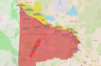
Some evacuation warnings have been changed to Evacuate Now orders. The most current map is available at the Perimeter Map website.
GO NOW EVACUATION ORDERS are in effect north and northwest of Somersett and north of Verdi as well as on the west side of US 395 for Golden Valley, Lemmon Valley, and Stead.
GET SET EVACUATION WARNINGS are in effect in portions of Stead, Golden Valley, and Cold Springs.
Perimeter Map
EVACUATION CENTER
Those needing to evacuate can go to the Evelyn Mount Northeast Community Center, 1301 Valley Road in Reno.
DISCOUNTED ROOM RATES:
If you are being evacuated, the Silver Legacy, Eldorado and Circus Circus Reno are offering a $59 room rate with no resort fee.
Call 1-800-223-7277 or book online with code SCLOC26.
J Resort is also offering a $59 discounted rate with no resort free. Use the code HAWK26 when booking online.
ROAD CLOSURES:
U.S. 395 is closed in both directions from Parr Boulevard to Red Rock Rd.
N. Virginia Street is closed between Red Rock Rd. and White Lake Pkwy
________________________________________________________
Aug. 22, 3:40 p.m. update:
The Hawk Fire is west Reno has burned an estimated 2,500 acres and is 0% contained since starting around 11 a.m. Saturday.
According to Truckee Meadows Fire and Rescue, the fire is moving northeast with approximately 1,000 homes threatened.
Local, state, and federal fire crews are on the scene with airtankers and at least 2 helicopters. More resources are being requested from Cal Fire.
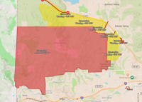
Evacuations are in place and can be seen on the Perimeter Map website.
Perimeter Map
GO NOW EVACUATION ORDERS remain in effect north and northwest of Somersett and north of Verdi.
Residents near the immediate area should remain alert and prepared, as conditions can change rapidly.
GET SET EVACUATION WARNINGS remain in effect on the west side of US 395 for Golden Valley, Lemmon Valley, and Stead.
Those needing to evacuate can go to the Evelyn Mount Northeast Community Center, 1301 Valley Road in Reno. Washoe County Human Services Agency, Allied Security, and American Red Cross of Nevada staff are there ready to assist.
The Hawk fire has also led to evacuation warnings in Sierra County, California. See the latest California warnings on the Genesys Map.
DISCOUNTED ROOM RATES:
If you are being evacuated, the Silver Legacy, Eldorado and Circus Circus Reno are offering a $59 room rate with no resort fee.
Call 1-800-223-7277 or book online with code SCLOC26.
J Resort is also offering a $59 discounted rate with no resort free. Use the code HAWK26 when booking online.
ROAD CLOSURES:
North Virginia Street is currently closed between Red Rock Rd. and White Lake Parkway.
_______________________________________________________________
Aug. 22, 2:30 p.m. update:
Reno Fire and Truckee Meadows Fire and Rescue crews are fighting a fire burning north of Cold Creek Trail, north of Somersett in west Reno
An additional 10 engines, 2 dozers and 2 hand crews have been requested from CAL FIRE by Incident Command.
So far, the fire has burned an estimated 2,500 acres.
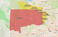
Evacuations are in place and can be seen on the Perimeter Map website.
GO NOW EVACUATION ORDERS are in effect north and northwest of Somersett and north of Verdi.
While the majority of the evacuation area is unpopulated, residents near the immediate area should remain alert and prepared, as conditions can change rapidly.
GET SET EVACUATION WARNINGS are now in effect on the west side of US 395 for Golden Valley, Lemmon Valley, and Stead.
Perimeter Map
Hawk Meadow Trail is closed north of Somersett Parkway.
California evacuation warnings
The Hawk fire has also led to evacuation warnings in Sierra County. See the latest California warnings on the Genesys Map.