
Tropical Storm Edouard made landfall near Johnson Bayou, Louisiana, at 3:20 p.m. EDT. FOX Weather Meteorologist Ian Oliver analyzes the compact storm alongside National Hurricane Center Deputy Director Jamie Rhome.
THE TAKEAWAY
Tropical Storm Edouard is lashing the Texas and Louisiana coasts, and is currently making landfall.Edouard is expected to unleash heavy rain, storm surge and flash flooding along the northwest Gulf Coast, as well as parts of Southeast Texas and southwestern Lousiana.Edouard strengthened from a Potential Tropical Cyclone to a full-blown tropical storm within the span of 9 hours Monday.
Tropical Storm Edouard has made landfall as the compact storm brings heavy rain, storm surge and flash flooding along the Upper Texas and southwestern Louisiana coasts as it tracks inland through the day.
Edouard made landfall near Johnson Bayou, Louisiana, roughly 15 miles south-southeast of Port Arthur, Texas, at 3:20 p.m. EDT, packing maximum sustained winds of 60 mph and a minimum central pressure of 996 mb, according to the National Hurricane Center (NHC).
LATEST FROM FOX WEATHER HURRICANE SPECIALIST BRYAN NORCROSS
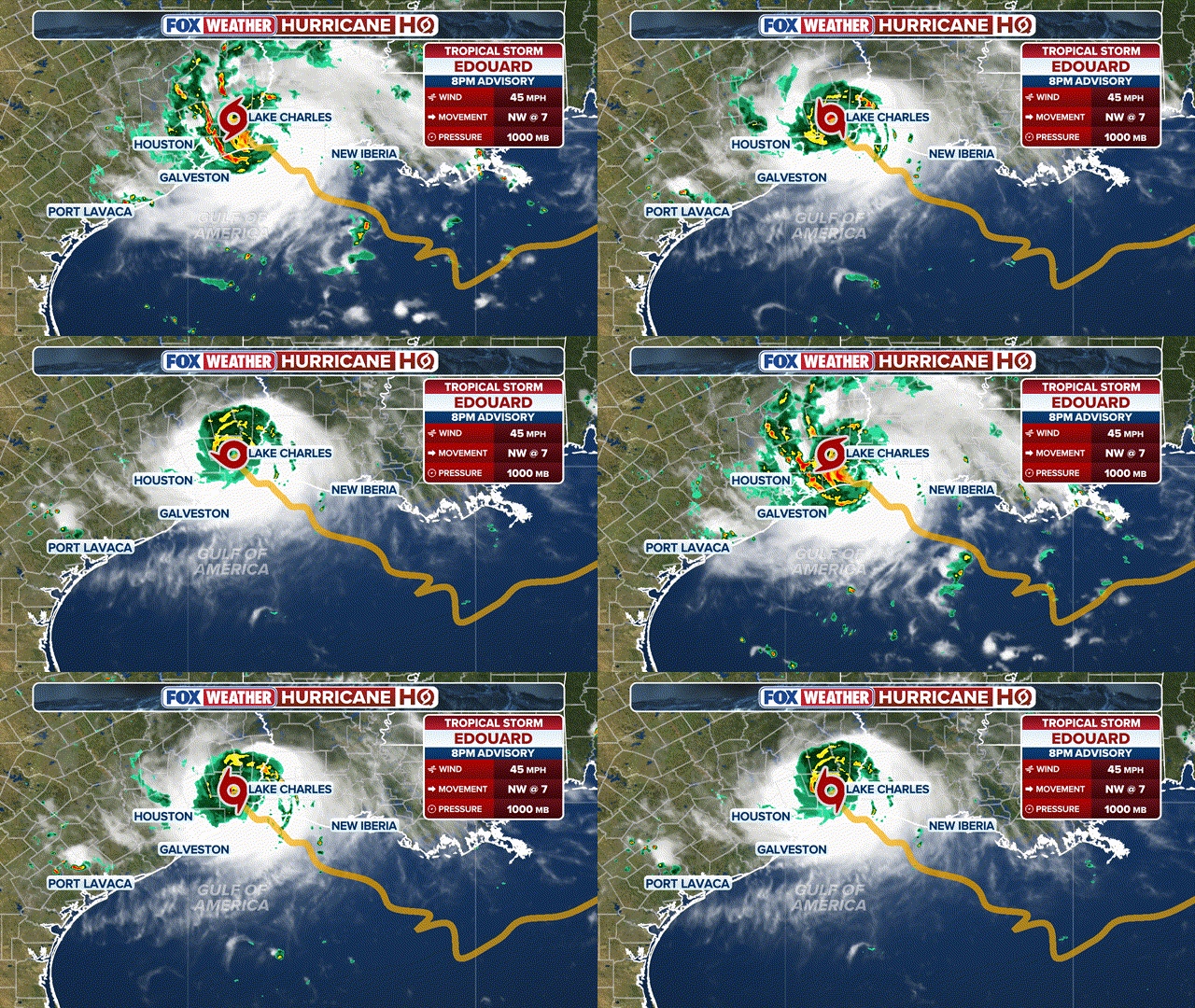 Tracking Edouard
 (FOX Weather)
Just before landfall, the storm took a last second jog to the west, delaying the initial landfall, the FOX Forecast Center said, adding, “It’s extremely hard to predict when these things happen.”
According to atmospheric data collected by Air Force Hurricane Hunter aircraft, Edouard strengthened as it approached the Gulf Coast, with maximum winds increasing in the hours before landfall.

Edouard Landfall Statistics.
(FOX Weather)
KARINA STRENGTHENS INTO A CATEGORY 4 HURRICANE AS THE PACIFIC TROPICAL TRAFFIC JAM INTENSIFIES
Tropical Storm Edouard impacts and timing
Over 45,000 are without power in Texas alone, as the impacts of Edouard are being felt along the Gulf Coast, according to data from poweroutage.com.
After making landfall in Louisiana, the storm will track north-northwest into Texas, gradually weakening as it moves inland.
Rain from Edouard’s outer bands lashed southwestern Louisiana early Tuesday, including Lafayette.
 Tracking Edouard
 (FOX Weather)
Tropical-storm-force winds between 39 and 73 mph are starting to lash the southeastern Texas and southwestern Louisiana coastline.
A Tropical Storm Warning remains in effect for the northwestern Gulf Coast from Port Bolivar, Texas, to the Vermilion/Cameron Parish line in Louisiana.
A Hurricane Watch, which indicates that winds of 74 mph or stronger are possible, covers the area from High Island, Texas, to Cameron, Louisiana.
 Watches and warnings
(FOX Weather)
A Storm Surge Warning is in effect for life-threatening storm surge — water above the usual high tide — from High Island to the Vermilion-Cameron parish line in Louisiana. Between 3 and 5 feet of surge is possible in this area, with 1 to 3 feet of surge possible from the Vermilion-Cameron parish line to Morgan City, Louisiana.
FLOOD THREAT CONTINUES ACROSS THE SOUTHEAST AS TROPICAL DOWNPOURS SOAK THE REGION
Edouard is expected to bring heavy rain to the region through Tuesday evening into Wednesday morning, likely leading to flash flooding, according to the NHC.
Rain and flooding threat for Southeast Texas and southwestern Louisiana
Tropical Storm Edouard is expected to drop a widespread 3 to 6 inches of rain across the Upper Texas Coast and east-central Texas, with localized pockets of up to 9 inches of rainfall through Wednesday.
The NHC warned a tornado or two is possible Tuesday afternoon as the storm moves ashore.

Expected rainfall
(FOX Weather)
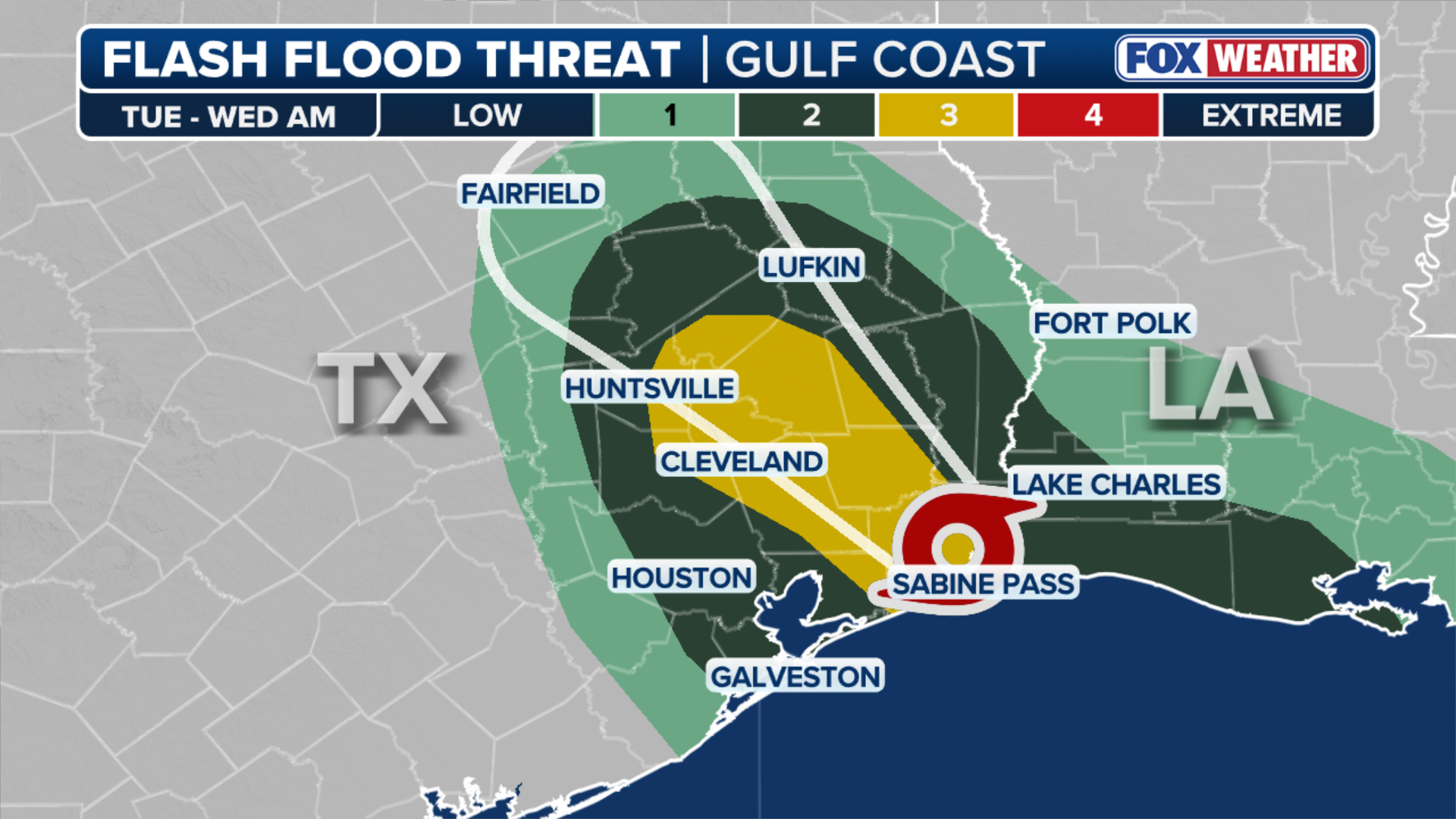
The Houston metro area is under a Level 2 out of 4 risk of flash flooding through Wednesday morning, as well as parts of southwestern Louisiana, including Lake Charles. Meanwhile, a Level 3 flood threat was issued Tuesday afternoon for parts of the Piney Woods and Big Thicket regions of Southeast Texas, including Beaumont and Livingston.
The National Weather Service (NWS) warned that low-lying and urban areas are particularly vulnerable to flash floods. The NWS also said river flooding might be possible along Edouard’s track.
Just after landfall on Tuesday, the National Weather Service Lake Charles said rainfall rates 4 inches were over Port Arthur, with more rain expected.

Scenes from Port Arthur, Texas, as Tropical Storm Edouard’s outer rain bands soaked the Gulf Coast on Tuesday.
(FOX Weather)
Edouard is a small storm in terms of overall size, with tropical-storm-force winds extending just up to 25 miles from its center, meaning the heaviest pockets of rain will likely be more localized.
TRACKING TROPICAL STORM EDOUARD: FORECAST CONE, RAIN, WIND AND RADAR MAPS
About 2 to 4 inches of rain is expected across southwestern Louisiana. Early Tuesday, FOX Weather Hurricane Specialist Bryan Norcross said that the heaviest rain is forecast east of Interstate 45, but could shift depending on the storm’s track.
 Tuesday flash flood threat
(FOX Weather)
The Galveston Independent School District canceled classes Tuesday ahead of the storm’s arrival.
“Depending on how quickly Edouard moves inland, there could be flooding well north of Houston on Wednesday,” the FOX Forecast Center said.
A Level 2 flood threat stretches along the I-45 corridor from northeast Houston to Corsicana, Texas, extending west to College Station on Wednesday.
Tropical Storm Edouard is expected to “significantly strengthen” before slamming the Upper Texas and southwestern Louisiana coasts later this afternoon. Tropical-storm-force winds could arrive by 8 a.m. along the shore. FOX Weather Meteorologist Britta Merwin has the forecast from Kemah, Texas.
Tropical Storm Edouard developed quickly
Tropical Storm Edouard developed quickly from a cluster of thunderstorms in the northern Gulf Friday evening.
The cluster was tagged as Invest 97L on Saturday afternoon.
WHAT IS AN INVEST DURING HURRICANE SEASON?

Tropical Storm Edouard development timeline
(FOX Weather / FOX Weather)
From there, Edouard strengthened from a Potential Tropical Cyclone to a full-blown tropical storm within the span of 9 hours Monday afternoon.
A Potential Tropical Cyclone permits the NHC to issue routine advisories on a system that has not yet developed into a tropical depression or tropical storm.
Stay with FOX Weather for live coverage as we track Tropical Storm Edouard.