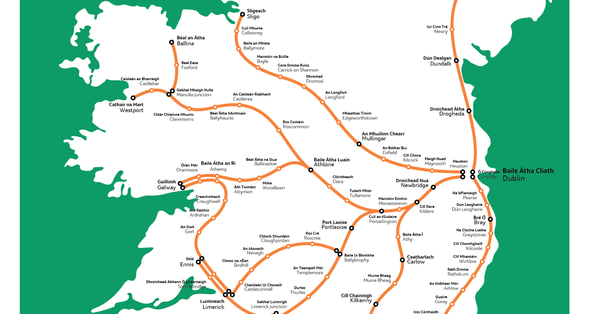
Is Portarlington the most OP train station in Ireland? So many options! Fair play to the lads.
The limerick to galway line should really only be one line from limerick to Athenry.
I like it. Also sad Donegal is blank
Maybe I’m looking at it wrong but it sure looks like it’s got the sligo line coming out of Heuston instead of Connolly.
Is there a chance the track could bend?
She’s got curves in all the right places.
The second greatest crime against our nation was closing all the railways.
Perfect for a HST train that leans into the bends! So basically about 30% of the island is bereft of any track. The Rosslare Waterford line closure really was foolish in retrospect.
Seems to be more of an artists impression of a railway map of Ireland
Few mistakes and inconsistencies in it..
Stupid sexy rail intercity network map
It’s a disgrace that Donegal and the North West is simply ignored
I agree, fuck Donegal, Monaghan and Cavan
“And fuck you if you live anywhere between Sligo and Belfast”
Don’t know about the rest but that Dublin to Wexford curve is definitely wrong. Has towns that are along the coast further out than towns that aren’t
Poor Donegal 😢
You can go almost everywhere except Donegal
Damn that intercity network map be thicc.
Still pisces me off that to go from nearly any part of the country to any other you have to go through Dublin.
It’s a Dublin centric country. 🙄
It’s less intercity and more Dublin to other cities…….and Kilkenny
This map is missing an extension of the line north of Sligo to Derry via letterkenny, with a spur from letterkenny to Enniskillen. Also a line from Derry to Dublin through strabane, omagh and monaghan. Basically following the main derry to Dublin Road. Might happen in the next 100 years if we’re lucky.

23 comments
Source: http://www.inat.fr/map/irish-rail/
Is Portarlington the most OP train station in Ireland? So many options! Fair play to the lads.
The limerick to galway line should really only be one line from limerick to Athenry.
I like it. Also sad Donegal is blank
Maybe I’m looking at it wrong but it sure looks like it’s got the sligo line coming out of Heuston instead of Connolly.
Is there a chance the track could bend?
She’s got curves in all the right places.
The second greatest crime against our nation was closing all the railways.
Perfect for a HST train that leans into the bends! So basically about 30% of the island is bereft of any track. The Rosslare Waterford line closure really was foolish in retrospect.
Seems to be more of an artists impression of a railway map of Ireland
Few mistakes and inconsistencies in it..
Stupid sexy rail intercity network map
It’s a disgrace that Donegal and the North West is simply ignored
I agree, fuck Donegal, Monaghan and Cavan
“And fuck you if you live anywhere between Sligo and Belfast”
Don’t know about the rest but that Dublin to Wexford curve is definitely wrong. Has towns that are along the coast further out than towns that aren’t
Poor Donegal 😢
You can go almost everywhere except Donegal
Damn that intercity network map be thicc.
Still pisces me off that to go from nearly any part of the country to any other you have to go through Dublin.
It’s a Dublin centric country. 🙄
It’s less intercity and more Dublin to other cities…….and Kilkenny
This map is missing an extension of the line north of Sligo to Derry via letterkenny, with a spur from letterkenny to Enniskillen. Also a line from Derry to Dublin through strabane, omagh and monaghan. Basically following the main derry to Dublin Road. Might happen in the next 100 years if we’re lucky.
Where’s the Belfast -> Derry line?
We have come a long way since 1920…lol..https://www.google.com/search?q=irish+railway+lines+1900&newwindow=1&client=ms-android-oppo-rvo3&prmd=inmv&source=lnms&tbm=isch&sa=X&ved=2ahUKEwiQx8XNht_8AhWNScAKHcj_D-oQ_AUoAXoECAIQAQ&biw=360&bih=626&dpr=2#imgrc=ydMO9EgiZNnq3M&imgdii=_ziM0GH7YpdxhM