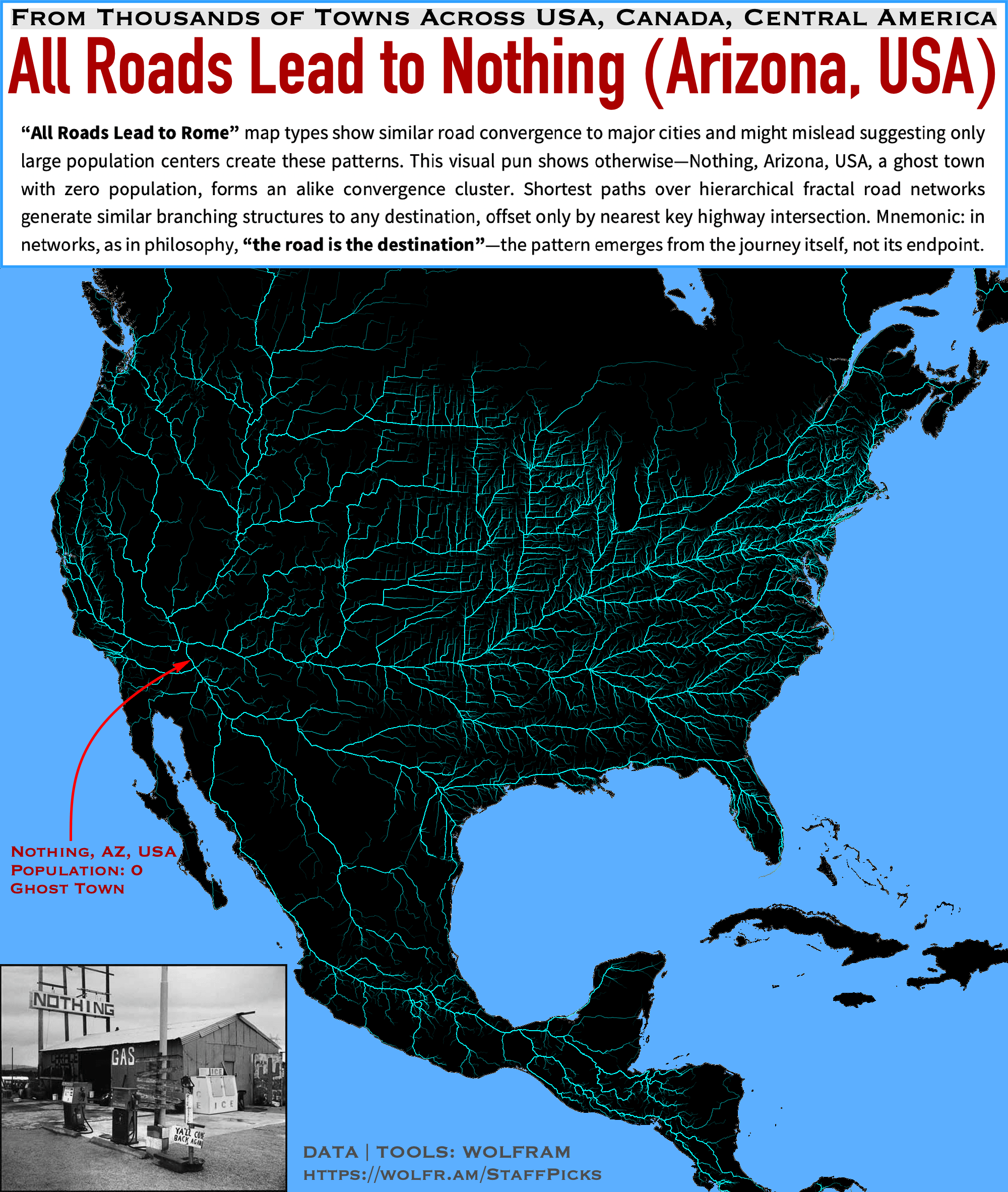
I computed the shortest routes from all 37,000 cities and towns across the US, Canada, and Central America, all converging on Nothing, Arizona — a ghost town with zero population. Despite the lack of a major urban center, the map still shows pronounced clustering, illustrating how hierarchical, fractal-like road networks naturally funnel routes onto key highways. I generated multiple randomized samples of paths and combined them, emphasizing the persistent branching effect that echoes “All Roads Lead to Rome.” Yet here, the real takeaway is that the journey itself defines the pattern, no matter where you end up, even in zero-population places.
All those incredibly long and straight roads in the mid west…
Very cool!
Can you do one of Europe?
Aka, the fastest routes out of Nothing, AZ.
It’s funny, looking at this you’d think Nothing, AZ was some sort of super important hub with all road networks branching from it, when the truth is quite the opposite.
I’m confused as to what this is meant to demonstrate. (Or, frankly, how it shows that the pattern doesn’t depend on the endpoint, or what “the road is the destination” is supposed to mean.) Is it that instead of having it calculate from Nothing, AZ to all the 37,000 places, it was done in reverse, and you still got the same kind of fractal pattern?
There’s only one shortest path between two points on a road network (for a given level of detail) so what’s surprising about this?
Am I just missing something?
Also, what do the thicker lines indicate, larger roads or roads more heavily used during these 37,000 trips? And to what degree do those things correlate?
Edit: If any point generated a similar pattern, then the complexity of the “fractal” would be proportional to the distance from origin. Except that’s only how it works for tiny places in the middle of nowhere, if you start in a place with a really high population and road density, it’s the opposite. So you don’t actually get the same pattern regardless of where you start.
It’s mostly just a really complicated plot of population density mixed with road network density/quality. (Which is a very common thing on this sub.)
Huh, now you can’t even see Nothing. Big pile of I guess road building stone in front of it. But if you jump in the U-Turn lane on streetview it goes back to 2021 and you can kinda see it.
Very cool, I didn’t know wolfram could do this. Am I correct that you need to pay to use wolfram?
Very cool, thanks for sharing 🙂
Could you iterate this over each state and find out where the truly most accessible location in the US really is? For example, just looking at this map seems to show 4 highways converging north of Nowhere. Seems like all roads lead actually lead up there…
All roads lead everywhere a road is.
For additional context on the type of maps OP is referencing, check out posts like this:
OP is making the point that you can generate very similar maps even if there is nothing unique about the destination itself, which I personally find very interesting 🙂
man. This post shown the original intent of “data is ***beautiful”***
![[OC] All roads lead to Nothing (Arizona, USA) -- Fractal shortest paths in road networks](https://www.europesays.com/wp-content/uploads/2025/03/aqby9knrceme1-1920x1024.png)
13 comments
TOOLS: Wolfram Language
DATA: Wolfram|Alpha
Article with code and details of the visualization:
[https://community.wolfram.com/groups/-/m/t/3403335](https://community.wolfram.com/groups/-/m/t/3403335)
I computed the shortest routes from all 37,000 cities and towns across the US, Canada, and Central America, all converging on Nothing, Arizona — a ghost town with zero population. Despite the lack of a major urban center, the map still shows pronounced clustering, illustrating how hierarchical, fractal-like road networks naturally funnel routes onto key highways. I generated multiple randomized samples of paths and combined them, emphasizing the persistent branching effect that echoes “All Roads Lead to Rome.” Yet here, the real takeaway is that the journey itself defines the pattern, no matter where you end up, even in zero-population places.
All those incredibly long and straight roads in the mid west…
Very cool!
Can you do one of Europe?
Aka, the fastest routes out of Nothing, AZ.
It’s funny, looking at this you’d think Nothing, AZ was some sort of super important hub with all road networks branching from it, when the truth is quite the opposite.
I’m confused as to what this is meant to demonstrate. (Or, frankly, how it shows that the pattern doesn’t depend on the endpoint, or what “the road is the destination” is supposed to mean.) Is it that instead of having it calculate from Nothing, AZ to all the 37,000 places, it was done in reverse, and you still got the same kind of fractal pattern?
There’s only one shortest path between two points on a road network (for a given level of detail) so what’s surprising about this?
Am I just missing something?
Also, what do the thicker lines indicate, larger roads or roads more heavily used during these 37,000 trips? And to what degree do those things correlate?
Edit: If any point generated a similar pattern, then the complexity of the “fractal” would be proportional to the distance from origin. Except that’s only how it works for tiny places in the middle of nowhere, if you start in a place with a really high population and road density, it’s the opposite. So you don’t actually get the same pattern regardless of where you start.
It’s mostly just a really complicated plot of population density mixed with road network density/quality. (Which is a very common thing on this sub.)
Huh, now you can’t even see Nothing. Big pile of I guess road building stone in front of it. But if you jump in the U-Turn lane on streetview it goes back to 2021 and you can kinda see it.
Very cool, I didn’t know wolfram could do this. Am I correct that you need to pay to use wolfram?
Very cool, thanks for sharing 🙂
Could you iterate this over each state and find out where the truly most accessible location in the US really is? For example, just looking at this map seems to show 4 highways converging north of Nowhere. Seems like all roads lead actually lead up there…
All roads lead everywhere a road is.
For additional context on the type of maps OP is referencing, check out posts like this:
* [https://www.reddit.com/r/dataisbeautiful/comments/ky076l/all_roads_lead_to_rome_this_map_is_visualises_the/](https://www.reddit.com/r/dataisbeautiful/comments/ky076l/all_roads_lead_to_rome_this_map_is_visualises_the/)
* [https://www.reddit.com/r/dataisbeautiful/comments/noojrw/oc_the_quickest_route_along_primary_roadways_to/](https://www.reddit.com/r/dataisbeautiful/comments/noojrw/oc_the_quickest_route_along_primary_roadways_to/)
OP is making the point that you can generate very similar maps even if there is nothing unique about the destination itself, which I personally find very interesting 🙂
man. This post shown the original intent of “data is ***beautiful”***
Comments are closed.