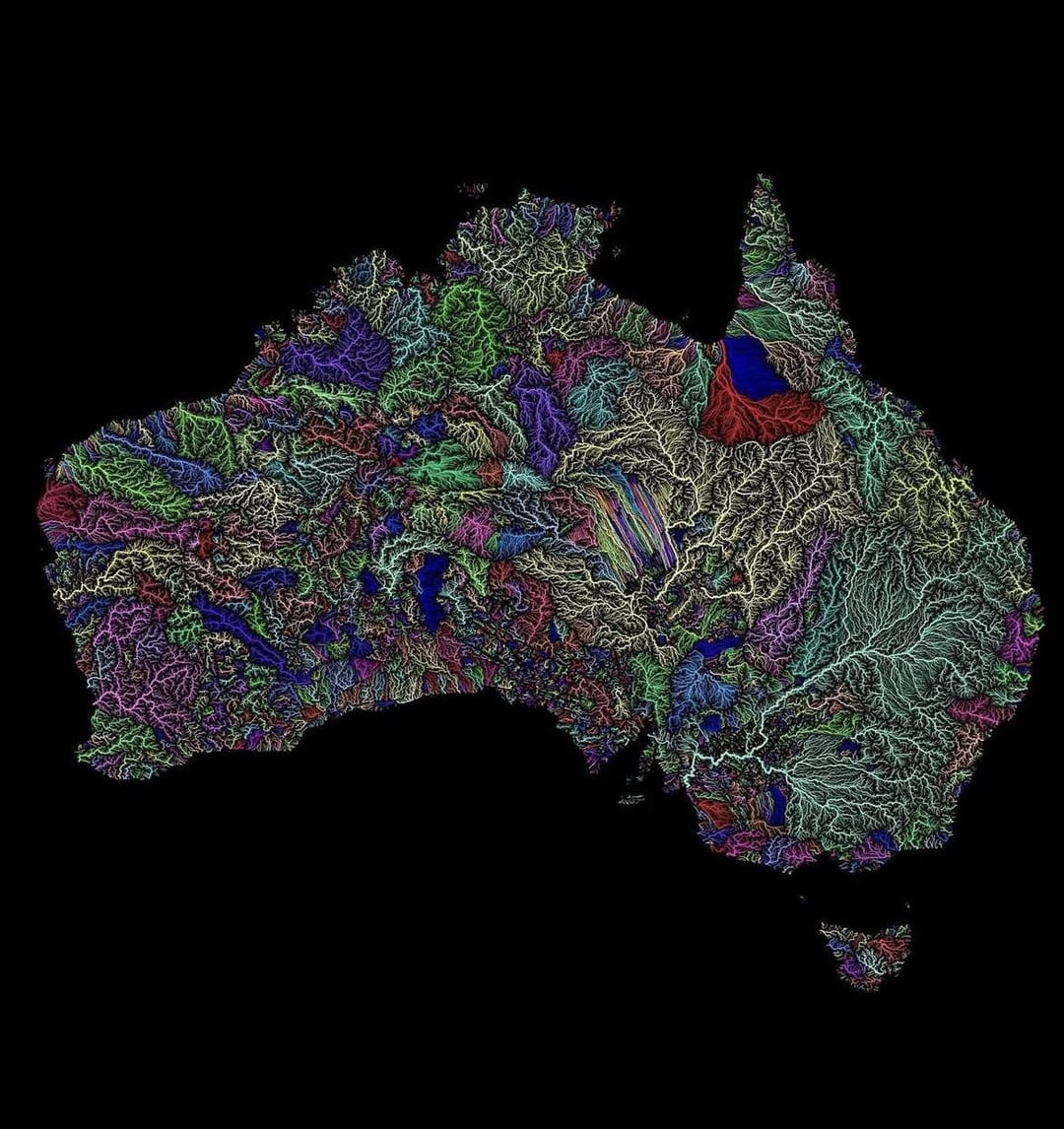
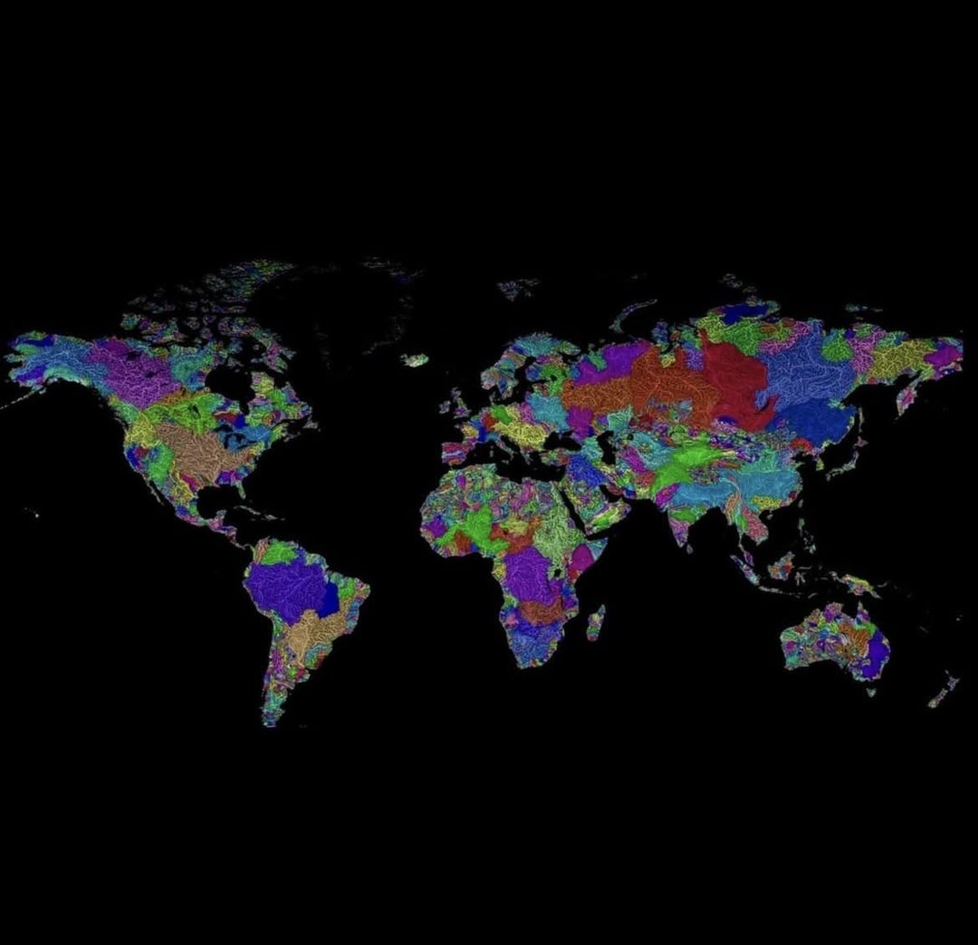
Would anyone happen to know whats going on here in Australia?
How much do you charge for a high definition, large scale version of the large, world scale, map?
Crusader Kings map gore 😀
Now that’s some beautiful data, wow
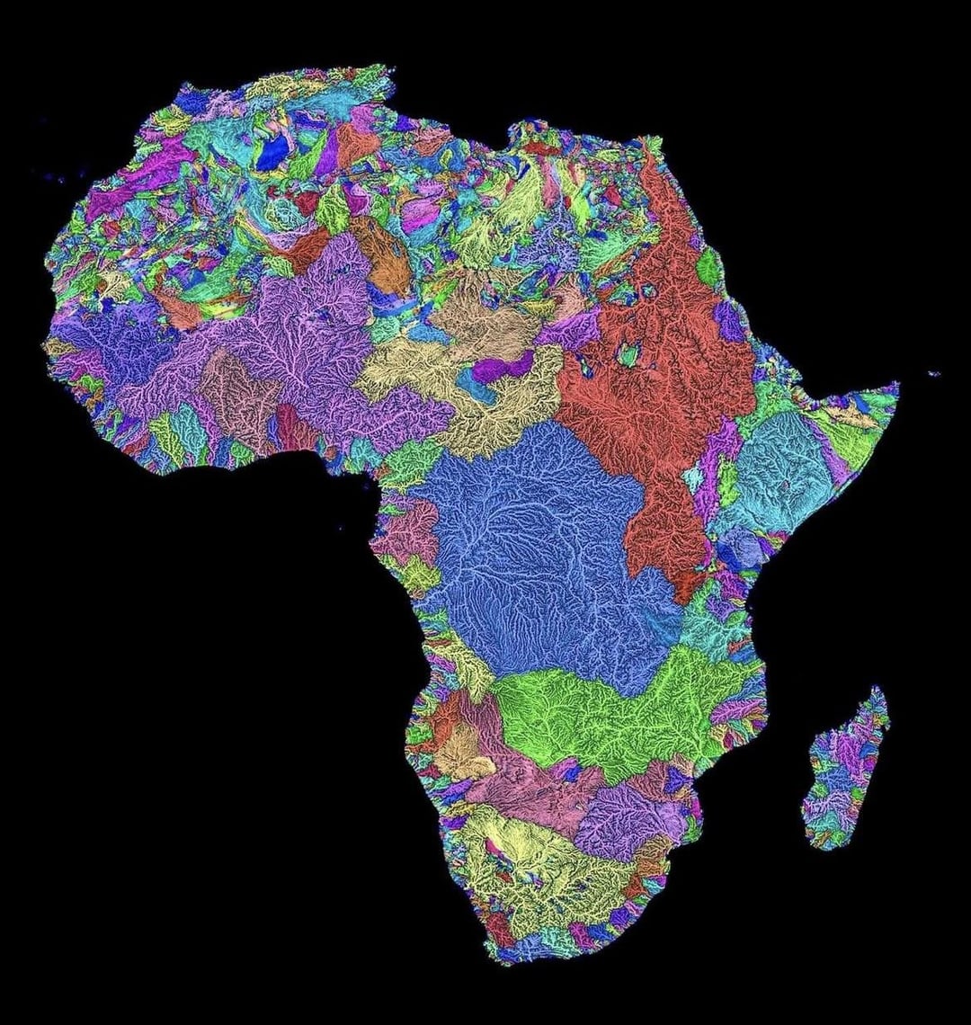
It looks like there’s a mistake in Africa. The big pink one (the Niger river i think) just stops dead in the middle, what’s going on there? It looks like mismatched parts.
Please stop stealing other people’s work. How hard would it be to attribute the artist?
What’s always amazed me is how narrow the Lake Michigan basin is at Chicago. I would love to find a high-res map of that to see if the house I had there in the 90s was in that basin or not; it would be close.
Once I cycled “arround” a small river.
Like if you take any river and start at one end and follow the watershed (color boundaries) you will end up at the other side of the river, without crossing ANY river or stream.
It was quite a challenge, crossed many fields (after harvest) and forrests to avoid crossing any flowing water, but stayed on tracks/roads when possible. I used a fatbike, in alpine regions this would quickly escalate into rock climbing. It was a fun project, had some straight line mission vibes, but not as hard.
Probably not very accurate anymore, though.
This is so rad! It’s so impressive how massive some of the watersheds are!

30 comments
The Mississippi is really something else.
Data really is beautiful…hats off.
One of the best posts I’ve seen here. Beautiful indeed!
Wow what an incredible way to see the world. All of a sudden it makes a lot of sense why the lakes are where they are.
The black is a basin from all the surrounding rivers accumulating there
Gorgeous AND informative. Well done!!
This is the most beautiful data I have seen in here for quite a while. It’s amazing to see the vast areas that some of the bigger systems cover.
These maps are beautiful! How did you make these?
I feel like you watched Any Austin recently…
It’s magnificent, you can try to market it!
Knowing that all these rivers have a single outlet, so 1 waste, one pollution… goes to the same place
What’s up with the colors? Different colors are different rivers that don’t connect?
also, interesting that the colors change from local view to global view
Did you create these? Are hi res available?
What’s up with the center of Australia? Where there are a bunch of different colored lines all parallel?
I might be incorrect here, but would this instead be considered water sheds? And not rivers?
TIL the Mississippi watershed is the 4th largest in the world
https://preview.redd.it/w9w6ln351xoe1.png?width=390&format=png&auto=webp&s=3ee8f01de9e97dda72bdf503192186b3596fb322
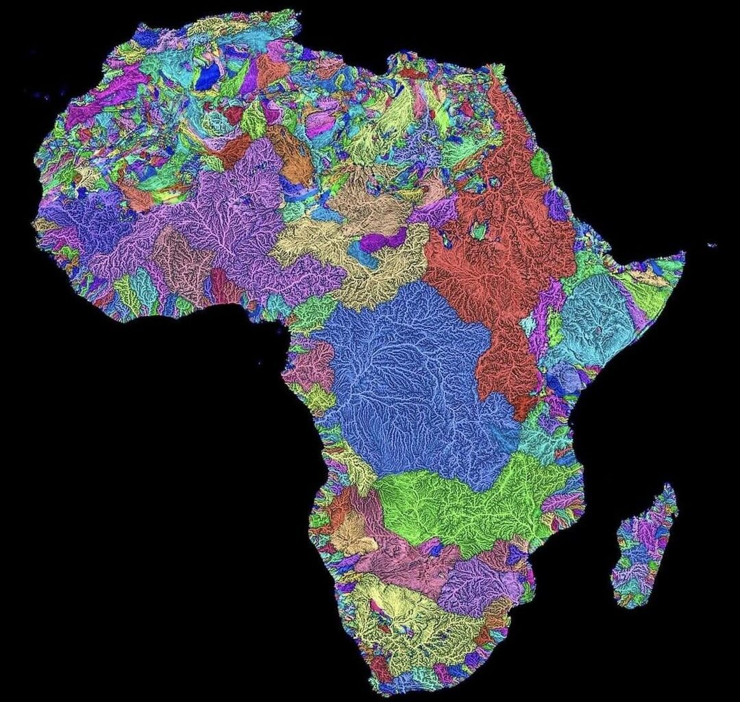
Would anyone happen to know whats going on here in Australia?
How much do you charge for a high definition, large scale version of the large, world scale, map?
Crusader Kings map gore 😀
Now that’s some beautiful data, wow
It looks like there’s a mistake in Africa. The big pink one (the Niger river i think) just stops dead in the middle, what’s going on there? It looks like mismatched parts.
Please stop stealing other people’s work. How hard would it be to attribute the artist?
Source: http://www.grasshoppergeography.com
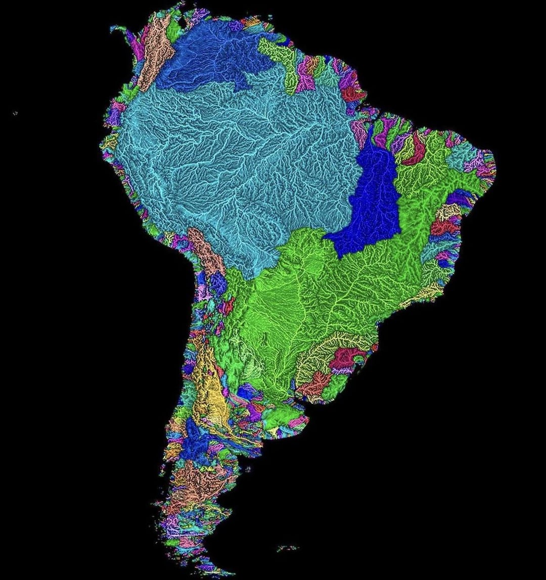
I love this. It’s the first time I’ve been able to really appreciate the sheer scale of the Amazon basin.
Goethe was always thinking in that terms to orient himself
In South America the Plate and the São Francisco should have more contrast but otherwise very cool.
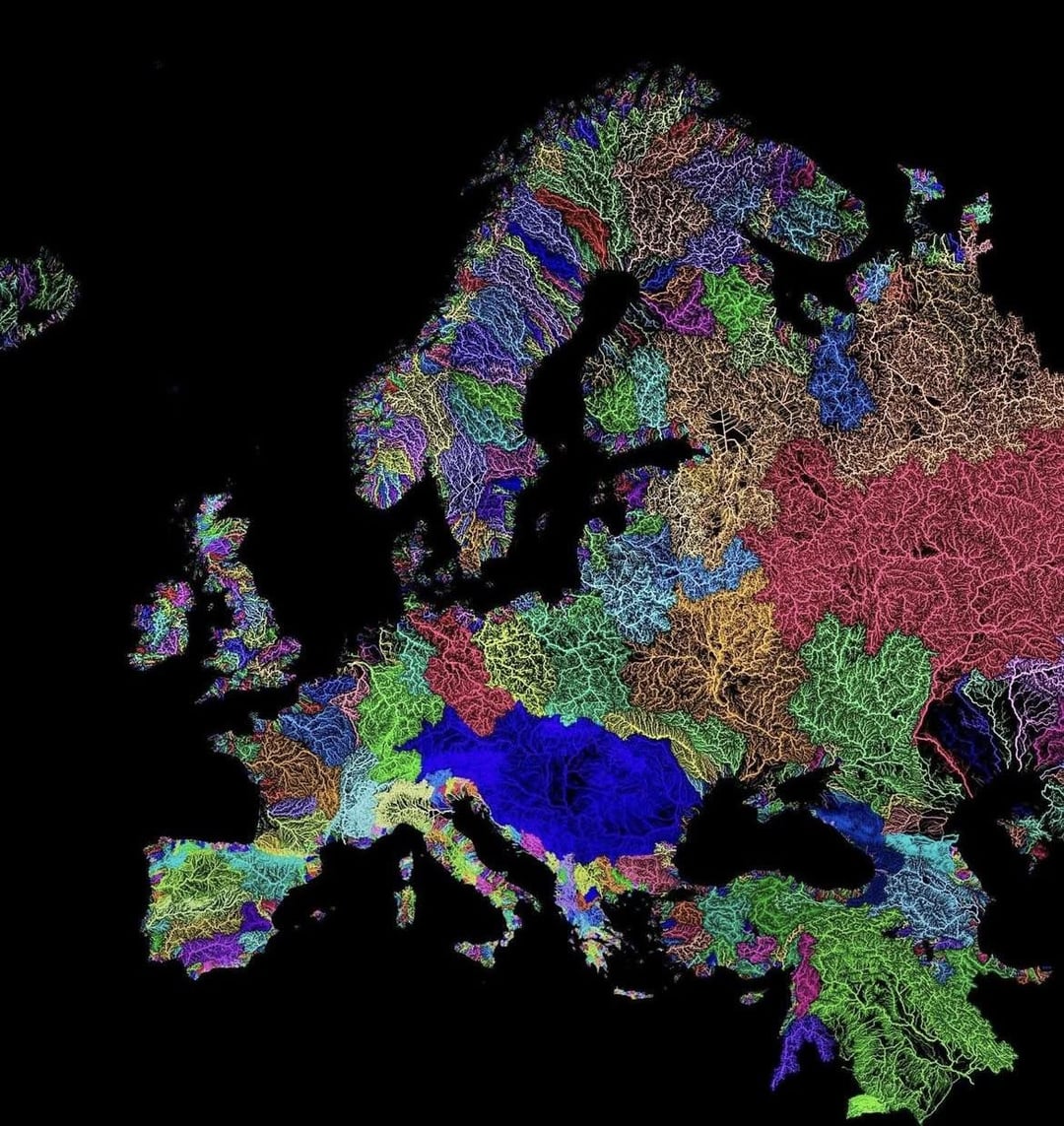
Fun fact: ALL of the rivers from Romania belong to the Danube system.
Credit to @GrasshopperGeography on Instagram
Question – is there a name for the little dark blue basin in the south east part of the Columbia River watershed? (Seventh map, US)
It’s not the Great Basin – I think that’s the magenta one – it must be some other[ endorheic basin](https://en.wikipedia.org/wiki/Endorheic_basin)?
What’s always amazed me is how narrow the Lake Michigan basin is at Chicago. I would love to find a high-res map of that to see if the house I had there in the 90s was in that basin or not; it would be close.
Once I cycled “arround” a small river.
Like if you take any river and start at one end and follow the watershed (color boundaries) you will end up at the other side of the river, without crossing ANY river or stream.
It was quite a challenge, crossed many fields (after harvest) and forrests to avoid crossing any flowing water, but stayed on tracks/roads when possible. I used a fatbike, in alpine regions this would quickly escalate into rock climbing. It was a fun project, had some straight line mission vibes, but not as hard.
Probably not very accurate anymore, though.
This is so rad! It’s so impressive how massive some of the watersheds are!
Comments are closed.