Some 62,000 people and 56,000 homes on and near the New Jersey Shore will see at least one annual flood because of sea-level rise by 2050, even if the world makes sweeping cuts to carbon emissions now, according to a new online tool released Wednesday by Climate Central, a New Jersey-based research and advocacy nonprofit.
The number of New Jersey residents facing annual flooding by 2050 rises to 68,000 under current “moderate” global commitments to reduce heat-trapping emissions, according to data from Coastal Risk Finder, an updated tool that allows users along the nation’s coastlines to identify and plan for their future flood risk under different scenarios.
Unchecked global climate pollution would result in 74,000 New Jersey residents in 66,000 homes facing increased flood risk over the next 25 years. The Climate Central tool uses sea-level rise projections by the United Nations’ Intergovernmental Panel on Climate Change for all three scenarios.
“Users wanted a simple, intuitive interface, and one that surfaces clear, takeaway messages while providing the depth and detail to back them up,” said Dan Rizza, director of the sea-level rise program at the Princeton, New Jersey-based group during a pre-release briefing for reporters. “It delivers clear, shareable messages.”
Please take a look at the new openings in our newsroom.
The new projections for the extent of sea-level rise and its effects on coastal areas are the latest effort to predict the impact of climate-driven ocean rise on the U.S. coast as a whole. In New Jersey, climate experts, academics and state officials are trying to anticipate sea-level rise effects on a low-lying, heavily developed and densely populated coastline that is especially vulnerable to rising seas.
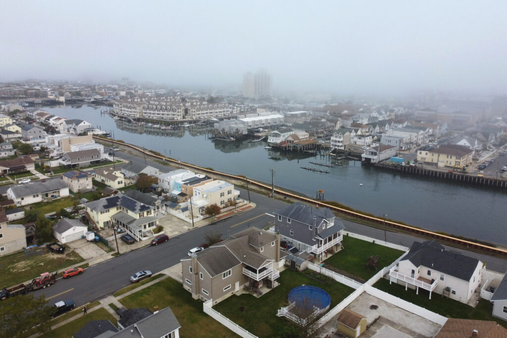
Another effort to anticipate coastal flooding in New Jersey as seas rise is NJ Adapt, a suite of data-visualization and mapping tools assembled by Rutgers University to help planners, businesses, communities and residents understand and adapt to climate-change effects. The project includes a Climate Planning Tool that explains why seas are rising, and tracks their effects on New Jersey communities, including Atlantic City. There, seas have been rising by 0.15 millimeter a year for the last century, exposing it to increased future flooding.
Lucas Marxen, co-director of the New Jersey Climate Change Resource Center at Rutgers, said the new Climate Central tool is easy for the public to navigate, provides clear information on areas at risk and offers citizens solutions to flooding, a feature that he said is not often found in such tools.
But he said the tool’s description of flood risk may lead users to misunderstand the frequency and severity of future floods. For instance, a “100-year” flood has a force that’s deemed to have a 1 percent chance of happening in any year, but which can happen more frequently than once a century, such as with Hurricane Irene in August 2011, which was closely followed by Hurricane Sandy in October 2012.
“The language used by Climate Central may mislead the public as to the real risk of these types of flood events,” he said.
Kelly van Baalen, project manager in the sea-level rise team at Climate Central, said that communicating the impact and frequency of major storms is challenging. “We acknowledge that it’s tricky to communicate the seriousness of low-probability but severe floods to the public,” she said. “We choose to label flood levels by their return period in our tool because it’s evocative, widely-used terminology, and frankly, you have to use a short name for a tool setting.”
As seas rise, floods of the 100-year magnitude will arrive on top of a higher sea level and reach further inland, the organization said.
For the New Jersey Shore as a whole, there’s a 50 percent chance that seas will be 1.4 feet higher by 2050 than they were in 2000, according to a projection by a Rutgers-led team in 2019. The forecast rises to 2.2 feet by 2070 under a “moderate” scenario for global emissions. The Rutgers projections are based on an increase in the mean global temperature of between 2 and 5 degrees Celsius above early-industrial levels by 2100.
The United Nations said in late 2023 that the world is “significantly off track” to meet the goals of the 2015 Paris climate agreement to prevent the global average temperature from rising by more than 2 degrees Celsius, and preferably 1.5 degrees. The U.N. said then that the world needed to cut at least another 20 gigatons of carbon dioxide equivalent to limit warming to 1.5 degrees by 2030.
This year, global efforts to cut carbon emissions have been further set back by the withdrawal of the United States from the Paris accord under the second Trump administration.
Slow progress toward the global emissions goals is manifested in the new Climate Central projections for New Jersey. The data tool anticipates that by 2050, the state will see a 3.3-foot coastal flood every year under an “intermediate” amount of sea-level rise. By 2030, a coastal flood of 2.7 feet can be expected every year, it said.
Often, coastal floods occur because extreme weather causes higher seas to flood land. But flooding can also occur under non-storm conditions like high tides, which is called “sunny day” flooding.
Climatologists say sea-level rise in the next 20 to 30 years is already “baked in” by current greenhouse gases in the atmosphere and won’t decline much even if there are sharp early cuts in global carbon emissions. That’s why the Climate Central tool projects that 56,000 New Jersey homes would face flooding in 2050 in a scenario with sweeping cuts, just 10,000 fewer than if climate pollution goes unchecked.
But sea level is expected to be more responsive to emissions cuts further into the future.
Within the state total, communities will be subject to different flooding scenarios. Cape May County, for example, with some of the state’s highest flood risk and many vacation homes, will have 22,000 homes at risk for annual flooding by 2050 if global climate pollution is unrestricted, according to the tool. Those numbers decline to 19,000 if there are “sweeping cuts now” in worldwide emissions.
Cape May County is especially vulnerable to flooding because as a peninsula, it is directly exposed on its ocean and bay sides to storm surge, sea-level rise and wetland inundation. Rising seas are killing some coastal marshes, reducing their role as buffers to tidal action. In all locations, flooding is worsened by paved surfaces, which increase runoff during storms.
Atlantic City, built on New Jersey’s vulnerable barrier islands, would see 4,000 homes at annual risk of flooding by 2050 in a scenario of unchecked climate pollution. Of the 9,100 residents at risk, most—8,000—are people of color, according to the tool. But the total population exposed to flooding would decline to 7,000 if there were deep cuts in greenhouse gas emissions.
The tool highlights actions that people can take to protect themselves and their homes, to recover from a flood and to get flood insurance. It describes state programs including Blue Acres, which since 1995 has been buying out repeatedly flooded properties from willing sellers at market prices. The houses are then demolished and their lots become open space that defends against future floods.
The tool updates Climate Central’s Surging Seas: Risk Finder, published in 2013, with new projections on sea-level rise, population, land elevation and coastal defense.
About This Story
Perhaps you noticed: This story, like all the news we publish, is free to read. That’s because Inside Climate News is a 501c3 nonprofit organization. We do not charge a subscription fee, lock our news behind a paywall, or clutter our website with ads. We make our news on climate and the environment freely available to you and anyone who wants it.
That’s not all. We also share our news for free with scores of other media organizations around the country. Many of them can’t afford to do environmental journalism of their own. We’ve built bureaus from coast to coast to report local stories, collaborate with local newsrooms and co-publish articles so that this vital work is shared as widely as possible.
Two of us launched ICN in 2007. Six years later we earned a Pulitzer Prize for National Reporting, and now we run the oldest and largest dedicated climate newsroom in the nation. We tell the story in all its complexity. We hold polluters accountable. We expose environmental injustice. We debunk misinformation. We scrutinize solutions and inspire action.
Donations from readers like you fund every aspect of what we do. If you don’t already, will you support our ongoing work, our reporting on the biggest crisis facing our planet, and help us reach even more readers in more places?
Please take a moment to make a tax-deductible donation. Every one of them makes a difference.
Thank you,