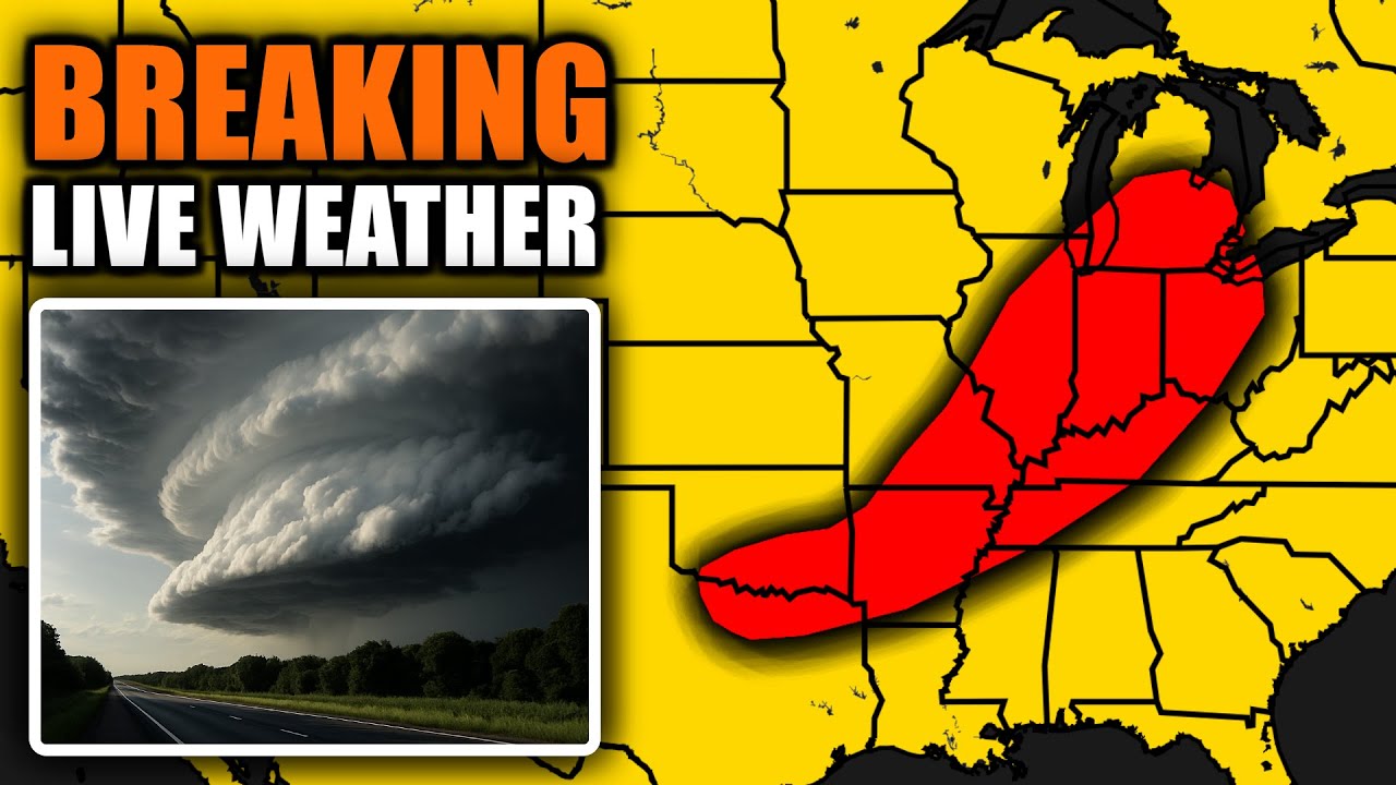
The June 18, 2025 Severe Weather Coverage, As It Happened…
are we live test test one two three should be getting there all right guys uh welcome to uh another Ryan Hall y’all live stream here it’s June 18th 2025 it’s 12:27 local 11:27 central 1627Z we’ve got a tornado uh doing damage out here near Pittsfield in uh Illinois okay so we’ve got uh tornado warning in effect right now for Calloon and Pike counties in Illinois i’m going to go ahead and uh pull up Stormrunner Media uh full here um as you can see that uh rotating uh part of the storm making intermittent contact with the ground there in the form of a multi-vortex tornado so we do uh want to encourage everybody to take shelter out here once again in Caloon and Pike counties in Illinois uh once again I just want to make sure that we are good to go here are we live somebody just say something in stream text just to make sure because I don’t have any way of knowing okay all right sweet all right so if you’re just now tuning in we’ve got a um a tornado warning currently for Calloon and Pike counties in Illinois uh once again we got a tornado on the ground here uh doing damage uh out here near New Canton so uh this is law enforcement confirmed and also we’re seeing this from um Stormrunner Media’s point of view as well okay so uh if you’re just now tuning in this is uh out here near New Canton really close to the town of Barry uh and uh we’ve got uh a tornado warning ongoing for um an an hour here for a population of 10,000 people uh in the um Adams and Pike counties areas in um portions of Illinois now we’ve got a much broader uh tornado watch in effect that uh is in effect for uh Bloomington Poria all the way over there towards Orbana Champ and Payne uh these storms are going to be coming towards you here uh shortly just in front of us guys all right so uh once again we just saw a tornado from Stormrunner Media’s point of view here out there near Pittsfield uh in um the the greater Milton area of Illinois and that’s also the uh uh the audio that you’re hearing in the background there that’s a live audio from Stormrunner Media let’s listen in the road okay we’re in the we’re in the uh that house okay winds are definitely broken so they’re traveling through the area where we just saw the tornado making contact with the ground uh not too long ago uh so it looks like the damage is minimal at least from what we can tell right now uh but this thing is still trying to produce a tornado as it goes off to the east uh towards Winchester uh we’re also watching a pretty significant area of rotation forming to the west of where our storm runner is right now over here near New Canton and I just want to go over some of these locations that are in the direct path of our uh potential tornado here we’ve got Cottonwood Island Campground the Pine Lakes Resort uh Barry High School um Griggsville High School uh Perry Middle School and then uh of course we’ve also got the Illinois State Police Troop uh office number six in Pittsfield it’s the Pittsfield post there all in the path here this is uh Interstate 72 between Barry and Griggsville uh once again it’s going to be a dangerous place to be over the next little bit uh as we continue to watch this uh supercell uh kind of uh get formed here now it was really visible when we saw it and and the interesting thing about this setup is uh if we come back over here to radar there’s actually not a lot of rotation visible here on the velocities like this is where that tornado was just coming from here um and if you come over to reflectivity you actually see a little embedded supercell over here just to the west of Pittsfield uh this is a place where I would look for another tornado to potentially happen here shortly as it goes up towards New Salem and Griggsville and then of course we’ve got a much larger embedded supercell structure over here between Eldara and New Canton so um that is what we are talking about right now out here in Pike County and Adams County in um Illinois now when we first went live this was an observed tornado warning it looks like it’s since uh lifted uh but this storm is going to be capable of producing a tornado warning here or a tornado soon uh we do have once again a radar indicated tornado warning currently uh for Adams and Pike counties in Illinois now we’ve got a tornado watch that is in effect for much of Illinois and Missouri as well and we just got that new uh severe thunderstorm warning uh for Morgan and Scott counties in Illinois with that tornado possible tag so let’s come back over here uh to the radar and uh inspect that one uh this is going to be for once again Morgan and Scott counties in Illinois winchester up there towards Bluffs we got about 6,000 people in the path of this dangerous storm once again Interstate 72 is going to be a dangerous place to be over the next little bit um over here uh and look at all these blips man look at all these blips uh that’s a pretty concerning looking one right here uh that looks like it could turn into something here as it gets closer to Springfield and Rochester uh we’re currently in Illinois right now so if you uh live out here around Springfield y’all watch out okay looks like a dangerous storm trying to get going right now let me put uh Copic up we do have Brandon Copic out there today and uh Jordan Hall i’m just making sure we’ve got all of our stormchasers pulled up and all that good stuff so uh once again I’m watching this storm very closely the one between Auburn and Pawne over here in Illinois uh y’all watch out in Edinburg Cotton Hill and Rochester that definitely looks like it’s going to be a problem for us uh as the storm gets closer uh I know we got people immediately tuning in from St louis there’s nothing going on right now in St louis we’re going to keep an eye on this but uh you guys are honestly it’s very likely that most of the severe weather is going to happen to the north and east of St louis today we’ll watch this area for some redevelopment here over the next little bit but I think that our main problem uh is going to be north and east of St louis i’m I’m concerned about Springfield to Bloomington up there towards Chicago and then even over there towards Indianapolis today is going to be a place to uh to keep a very close eye on uh as these storms continue to uh you know ramp up here so uh if you’re just now tuning in uh we do have uh tornado warning in effect right now for Adams and Pike counties in Illinois that’s going to go on for 42 more minutes morgan and Scott counties in Illinois are also under a um severe thunderstorm warning now uh we haven’t really um gotten started yet with our storm reports all of our top wind reports and top hail reports from today are from much earlier this morning um and uh that’s going to be uh for the a storm system that’s different than the one that we’re talking about right now but earlier this morning about 1:45 a.m we had a 72 mile per hour wind gust out there in Oklahoma and we had some 1-in hail out there in Arkansas i expect that all of these top uh reports will be replaced by stuff that’s happening in Indiana and Illinois today um and even up there towards Michigan uh as uh we’re going to be covering a very uh large area that is uh expected to receive severe weather uh this is what that looks like on the latest SPC outlook uh we’ve got an enhanced risk of severe weather from southern portions of Michigan including Lancing Calamazoo Jackson over there towards Toledo Ohio so the western side of Ohio is under an enhanced risk of severe weather today main threat is going to be damaging winds uh between Toledo and Cincinnati including uh Dayton uh and Finley uh the entire state of Indian or Indiana uh is under an enhanced risk today uh the eastern and southern side of Illinois a little bit of Kentucky on the western side and a little bit of southeastern Missouri that’s going to be our main target area today but of course there’s going to be storms happening from central Wisconsin or um Michigan sorry uh all the way down into Arkansas Oklahoma and um uh Texas so there’s going to be a point in today’s stream where we will probably be talking about Dallas and Detroit at the same time uh but the main focus area is going to be right here in the orange so um where are you guys watching from hello chat thank you for tuning in i know it’s um once again we we started a little bit early here uh because we you know we had a a tornado that was touching down just a few moments ago uh but I think that’s good because let’s say it’s another 30 minutes or so before we have another tornado touching down we’ve got time to talk about this right we’ve got time to answer questions we’ve got time to you know um you know look at the chat and all that good stuff so uh let me know where you’re watching from and also if you don’t care to do me a favor and uh go ahead and uh share our stream out there on social media put it out there on Tik Tok Facebook Instagram Twitter YouTube whatever whatever um that’s going to help us get potentially life-saving information out in front of more people now let’s take a look at what the radar could look like as we go into the future um this is pretty much what it looks like right now as we’ve got these storms forming back here uh between St louis and uh Springfield but what about a couple hours from now uh maybe uh 2 3 hours from now we’re going to see a much more robust area of convection uh kind of slicing through the middle of uh Illinois here we’re going to have some uh supercells out in front of that you know if we actually get something like this up here in front of that main line uh near Bloomington that’s almost guaranteed to try to produce a tornado uh this afternoon um and then we’re going to have embedded uh tornado problems within the line as well the main threat in these line segments today is going to be the hail and the damaging winds and that’s going to be moving into Evansville potentially around 2 to 3:00 p.m now Chicago uh yesterday it was looking like the storms were going to get there around 400 p.m today it looks about the same uh the good news is in in Chicago I I personally believe that the storms are probably not going to be uh very tornatic by the time they get to Chicago uh but it is something that we’re going to keep an eye on uh very closely because this northern little exist I’m sorry extent of the uh storm system here is where we’re going to have the most spin okay so if we do for some reason still have isolated convection we still have some uh supercells that are all by themselves and not getting squished up in that line when these get around Chicago we definitely have the threat for a tornado or two and that the same thing can be said for northern portions of Indiana up there towards South Bend Fort Wayne uh and then Indianapolis the storms will arrive around 4:00 as well and uh we’re going to see those uh bringing in some hail and some damaging winds also into Louisville maybe around 5 uh maybe closer to six for Cincinnati uh Dayton maybe six or seven uh Toledo and Detroit 7 to 8 uh and at this point the stuff’s going to start calming down even though we’re still going to have storms like kind of racing through uh central uh and even eastern portions of Michigan eastern portions of Ohio central and eastern Kentucky and we’re going to have some stuff down here in Oklahoma Arkansas and Tennessee uh this is not going to be as uh potent as uh the stuff that we’re going to be talking about over the next couple of hours in Illinois and Indiana uh but definitely watch out for these storms around Clarksville Tennessee today we will do a Clarksville check-in today all right I promise all right so once again if you’re just now tuning in y’all this is the the plan for today we’re going to be live here talking about significant severe weather uh in the yellow and orange areas if you know anybody that lives out there if your mom if your dad if your aunt your uncle uh lives out there and and you live over here you can still help out you can still contribute uh to what we’re doing here by just sending a quick text message and being like “Hey listen this guy’s talking about the weather you got weather and he’s going to be live on the air commercial free and free of charge uh for the duration of the event.” That’s the only way we have of getting our word out there we don’t have any we don’t have commercials we don’t have you you know what I’m saying like the only way this works is with your help so I really do appreciate it back to the radar uh this is what we’re talking about right now we’ve got a tornado warning in effect for 35 more minutes in Pittsfield uh in um Adams and Pike counties in Illinois who do we have uh with us today jared um let’s see here if you guys don’t care can we put in the um the green room the tornado watch graphic uh or Frank or who whoever’s available uh I’m going to show that right here in a moment um but uh we’ve got a a tornado warning in effect for Barry and Griggsville and um that’s going to be in effect for 34 more minutes we’ve got about 10,000 people uh potentially in in a dangerous spot here and this is what that looks like uh up close and personal now when we first went live we actually had a tornado on the ground associated with this storm and uh thankfully it lifted right around the time we started getting viewers in here okay so uh I at this point I don’t think we have a tornado on the ground but the storm that was responsible for that is still there and it’s spinning and it’s probably going to produce several more tornadoes today so we we got an early start on this but man uh that that rotation that just kind of kicked up uh over here to the uh west of Winchester looks pretty convincing so I wouldn’t be surprised if we saw another tornado from Stormunner Media’s point of view between Florence and Winchester over here in Illinois as this little embedded supercell these little bitty tiny things here are actually producing tornadoes today yeah it looked massive it was it was big it was multi vortex it was kind of you know it looked like it was about to be a big one so that’s the kind of stuff that we have to watch out for today as the storms uh continue to move uh off to the north and to the east maybe uh yeah I’ve got a bunch of uh traffic cameras pulled up right now but I’m going to start filling this out with some more uh stormchasers because we do have extreme stormchaser Luke Hatton out there brian Scholes out there uh Tester McTerson’s out there but we’re not going to use Tester McTerson today no dag on traffic cameras in Illinois you guys really got to do something about that for me i don’t know how you do it but uh you guys got to start a petition or some somebody’s got to call the do department of transportation or something the Illinois they’ve got you’ve got traffic cameras but they’re just pictures man and and like how are you supposed to see the tornado zip by in a rain wrap situation on a lowquality picture you can’t you got to have you got to see the motion on the road uh let’s see here bloomfield in Winchester once again you guys I I would say y’all watch out because we’ve got a potential tornado trying to wrap up here uh near y’all we should see something from Storm Runner Media’s point of view if there’s if there’s something down there that like they’re they’re really close to it let’s actually listen in to see what they’re saying pretty quiet right now this base is so low guys yeah like that that’s the thing that I noticed with the other one the bass is so low the clouds pretty much touching the dag on ground out there trying to see above this like the whole cloud was just like scraping against the ground i didn’t get that transmission but I’m I was thinking he might be saying some things we got low LCL’s today if you ever hear meteorologist Andy Hill or your you know your favorite weather nerd mention low LCL’s they’re just talking about clouds being really close to the ground and that’s exactly uh what we’ve got going on today and that’s why it’s honestly it’s going to be somewhat difficult to spot these tornadoes on radar today because you don’t need a whole lot of rotation um to to make the tornado happen whenever the the clouds basically sitting on the ground to begin with you know what I mean what would normally be a funnel cloud uh in a situation where the clouds were higher up off the ground could actually be a tornado be just simply because there’s less distance there so um that’s uh one of the things that we’re dealing with today and also uh we’re definitely in a little bit more of a complex terrain a new tornado warning has been issued um you can see that we’re often going to be interrupted by trees okay we just got a new to tornado warning over here to the east of Springfield now this is the storm that we were talking about um when we first you know started looking at these blips over here i wouldn’t be surprised if we saw several new tornado warnings issued here shortly uh around the Springfield area because uh we do have uh two maybe three supercells that are actually very close to being able to produce tornadoes right now okay right now so uh if you are in the Springfield area uh please uh you know take shelter especially on the eastern side this is for Rochester uh Dawson Buffalo Buffalo Hart uh Cornland um places over here in Logan and Sangaman counties uh we’re going to need you to take shelter immediately uh let’s pull up Storm Runner Media once again because he’s really close to the rotation that’s on that tornado warning near um well honestly the the Winchester storm isn’t under a tornado warning right now but it probably should be though uh but we’ll keep him above my head and we’ll come back over here to just south of Springfield Illinois uh this is our rotation right here now it doesn’t look that impressive at first glance but when you remember that these clouds are basically scraping the ground uh you’ll uh you remember that uh this is um potentially already producing a tornado uh down here between Beamington and Cotton Hill so we need you to take shelter up there especially in Rochester up towards Clear Lake and Dawson there’s about 35,000 uh people uh in the path okay so uh take shelter now Frank I don’t know if you heard but like uh if somebody can put the uh tornado watch graphic from the SPC in there that would be nice or I don’t know maybe it’s not even come out yet we got potentially tornado in progress right there guys these things aren’t really fully condensed very well um once again y’all this right here is the area of rotation and you can see very clearly the supercellular structure here on these storms and honestly I I wasn’t even expecting them to be this strong uh we knew that we were going to have many supercells today but they’re already kind of exceeding my expectations with how much hail and precipitation we’re seeing in the forward flank so these storms are strong uh things are definitely looking interesting here as there might be a tornado trying to form near Beamington right now so take shelter and then of course we’re watching this storm just to the east of that very closely as well it wouldn’t be surprising tornado warning if we got another tornado warning for that area here soon uh and here’s the other tornado warning that we were waiting on this is for the rotation over here near Winchester and this is what that storm looks like right now uh out there in Winchester Illinois so this is actually an observed tornado warning so uh according to law enforcement we do have a confirmed tornado on the ground out here um this is in Cass Morgan and Scott counties in Illinois let’s listen in on Storm Runner rapid motion i don’t I don’t think they’re seeing anything right now law enforcement observed what you guys think that it’s you guys got observed that was tornado so uh we’re going to keep an eye on them and uh we’re going to continue to call out some of these locations that uh could be in the path of a tornado here including Rickton Merritt uh Chapen Conquered Arensville Hagener Bluffs Springs and also um places over here near um Virginia and Philadelphia in Illinois take shelter immediately we’ve got a tornado on the ground out here according to law enforcement there might be too i mean look at the structure on this y’all we’ve got two very clearly uh defined hook echoes here um I wouldn’t be surprised if we had two tornadoes going on right now uh between Winchester Bloomfield and Lynville that’s in Cass Morgan and Scott Counties in Illinois please take shelter if you haven’t already guys if you’re just now tuning in we’ve got 5 million people under a tornado watch right now uh this is what we’re talking about we’ve got a couple tornadoes possible from St louis Cape Gerardo all the way up to Springfield Peoria and Champagne uh this is going to go until 400 p.m central uh 2in hail is possible and 70 mph winds as well uh we’ve also got uh some really cool pictures uh from uh Brian here some pictures from my travel from Pennsylvania to Texas thank you so much for sending that in and um if somebody could put that damage um photo in there as well I will also show that uh I see the one on Twitter there uh go um I’m going to go back to the radar for now though and uh we’re going to talk about this um tornado warning once again if you are in Cass Morgan or Scott counties in Illinois we need you to take shelter all right we’ve got a tornado on the ground according to law enforcement and it is getting ready to cross uh Interstate 72 there is a potential uh for um us having two tornadoes here so we’ve got two areas of rotation and if this is actually happening if we have a fully condensed funnel making contact with the ground here we’re going to be able to see it pretty soon from Storm Runner Media’s point of view so we’re following them very closely i’ll keep them above my head uh and and there are several other storms that we’re watching right now um it’s not just this one uh we’ve got some really intense stuff starting to form over here near Effingham uh and that’s actually where Cory Gerkin is i’m going to pull him up uh and I’m going to reload all these guys real quick and you can see that we are working with a bunch of stormchasers and we do have some traffic cameras but they’re down there in St louis we we’ve got absolutely nothing in um Illinois unfortunately unfortunately but yeah we we’re going to have a good view of these storms as they uh get going here between Champagne and Effingham and I believe if I’m not mistaken I believe we got a 10% uh tornado risk that was just added uh yeah so right before I started the stream as well uh they just added um an upgrade to the tornado probabilities so Indianapolis Champagne Effingham uh Teroot uh La Lefayet uh Loganport Marian up towards Fort Wayne you guys are all under a um 10% uh tornado risk today it was a 5% all the way up until now um and um they upgraded it so that’s actually a pretty intense risk uh for tornadoes there’s a pretty good chance that we’re going to see potentially several tornadoes today in the yellow area now we’re also concerned about the brown areas that includes Toledo Cincinnati Louisville Chicago up there towards Flint Michigan but especially concerned in the yellow zones uh and that’s also where uh we have the tornado watch right now so uh please uh get ready to uh take shelter if you end up under a tornado warning today uh speaking of tornado warnings we do have a couple uh in effect right now uh this is uh what we’re looking at here we’ve got three tornado warnings active uh we currently have a tornado warning in Cass Morgan and Scott counties in Illinois that’s law enforcement confirmed it’s going to last for 22 more minutes in Logan and Sangaman counties in um Illinois we’ve got a tornado warning that’s going to go on for 22 minutes as well and then over there in Pike County Illinois these two are radar indicated uh rotation all right dear let’s go back up close and personal with these uh storms here um the rotation is definitely still uh pretty uh evident here on radar now more so with one of the areas of circulation um we we had two uh that we were watching earlier but I think that everything’s kind of condensed into one now here rickton crossing Interstate 72 right now uh that’s moving up towards Markham uh and areas near Jacksonville Joy Prairie and Arcadia uh in Philadelphia in Illinois we need to be taking shelter if we haven’t gotten there already and Cass Morgan and Scott counties in Illinois now coming back over here to the storm just to the east of Springfield specifically in the towns of Rochester Dawson and Buffalo Hart the rotation here doesn’t look like it’s strengthening in like very rapidly but it’s also not going away so um if we don’t have a tornado with this yet uh one may be coming soon uh for the areas between Springfield and Rochester uh we’ve got to get ready on Highway 29 uh and then up there towards Interstate 72 between Riverton and Buffalo uh this is a dangerous storm take shelter in Logan and Sangaman counties in Illinois and then uh we do have 20 minutes left on this uh tornado warning for Pike County Illinois as there’s a significant amount of rotation down here between New Salem and Griggsville and uh yeah we’ve got a severe thunderstorm warning as well for Morgan and Scott counties in Illinois all right coming back over to Storm Runner Media i’m going to turn the volume up and I’m going to grab some audio from Mr copic as well i was like “Huh?” Now all of a sudden it looks really I apologize if you hear like two seconds of an ad go figure it is possible we had to making the attempt to go there i know well that was an eventful start to them it’s not even 12:00 yet sheesh i mean cop okay all right i got that figured out thank you guys for thousand likes let’s go let’s keep on running it up big W in the chat thank you guys for being patient with us we had a lot of disconnects no I’m just saying i mean before we had a few i’m just saying imagine that all right if you’re just now tuning in uh I’m still just getting some stuff ready here as we plan for several hours of uh coverage uh for our tornado situation that’s developing out here in Illinois Indiana little bit of Missouri but mostly we’re we’re concerned about Illinois and Indiana right now we’re not yet talking about Kentucky we’re not yet talking about Ohio um or Michigan okay i know we’ve got a lot of people in there in here that are concerned about those areas rightfully so at some point today we will have storms but not right now um uh speaking of um Illinois I I do kind of want to inspect some of these storms so the the ones that uh Corey Gerkin are getting close to the these over here near uh Matune in Illinois actually how do you say that maton matune uh in uh Illinois uh these are looking uh really interesting uh to me as well uh there’s no warnings or anything on these but I would say probably within the next 5 seconds we’re going to at least to see uh severe thunderstorm warnings issued for places like Effingham Shelbyville Paradise Maton uh up there towards Tuscola okay so um these uh storms right here are going to be something that we really have to watch as they move off to the east uh additionally uh little stuff like this uh that’s coming up towards Decar you got to watch that like a dag on hawk okay because these things can very quickly produce tornadoes you can you can’t really tell but there is some rotation here and um it’s these storms are kind of scraping the ground so it’s not going to cause much for a tornado to happen here um as it goes up towards Decar so um y’all watch out in Decar Illinois um as these storms are trying to produce tornadoes right now there’s also a really interesting looking sale over here uh north of Lomi Lomi I think is how you say that and uh this could lead to a tornado in the uh near future so we currently have a bunch of tornado warnings and then also a uh you know several storms that are not necessarily warned but probably should be uh and will be soon so this big uh supercell over here uh that is uh currently producing a tornado warning for Cass Morgan and Scott counties in Illinois that’s the one that Stormunner Media is on and uh you know we’ve actually got a pretty good view of the base of it here so uh we’re going to inspect it uh up close and personal still uh no wind or hail reports coming in just yet from the target area today like uh in Illinois and Indiana most of this is from this morning in uh Oklahoma Kansas and Arkansas but I imagine that we’re going to see lots of reports today mostly damaging winds reports I believe uh but uh that’s definitely going to be the case as we go forward uh additionally once again if you’re just now tuning in we’ve got three tornado warnings right now our number one top priority warning is that Cass Morgan and Scott County Illinois tornado warning where we’ve got law enforcement confirming a tornado on the ground here there’s 16 minutes left on that warning and this is what it looks like on radar so it does include Jacksonville in Jacksonville you guys are getting a pretty good downpour right now you got lots of thunder maybe some hail over there especially towards Markham uh the rotating part of the storm is back here and it’s kind of moving in this direction so um just uh stay sheltered for the next 16 minutes hopefully they’ll allow this warning to expire at some point looks like we just got a new tornado watch uh yeah we got we just got a new tornado watch that uh includes uh a bunch of Illinois and Indiana uh and a little bit of Michigan so um guys whenever we’ve we’ve got a image from X on that one uh go ahead and put it in the green room too if you don’t care so much over there in the field what else we got we’ve got a severe thunderstorm uh watch over here uh around um Washington DC and Baltimore so uh this is this adds another layer of uh uh complexity to our coverage today around the same time as things start popping off over there in um Illinois here in a few minutes we’re also going to have some large hail and damaging winds to talk about over here near Washington DC once again so um y’all get ready for this storm over here in Leburg over towards Germantown that does look like it’s going to be uh kind of plum wild as it brings in some golf ball size hail at some point I believe can’t really tell completely right now what these storms are are going to do because like we’re not necessarily in the the peak heating yet uh but this is what it looks like right now out there in uh the areas near Derwood uh just north of uh Washington DC there so it’s a pretty decent little gully washer right now but the these storms will become severe and likely produce power outages and hail damage as they work between Washington DC and Baltimore later philadelphia you guys are included in this and a lot of southern uh New Jersey and the entire state of Delaware is also under that severe thunderstorm watch there it is all right here is uh the latest tornado watch so this one’s got about 7 million people in there uh 75 mile per hour winds are likely a few tornadoes are likely oh so this is actually um this is actually a pretty I don’t know how to say it like this is pretty this is pretty good tornado watch guys uh we’ve got high probabilities uh technically uh of a few tornadoes likely uh scattered hail up to pingpong size possible and a 75 mile per hour wind so once again 7 million people are under this tornado watch that’s going to be uh Indianapolis Teroot Lefayet Fort Wayne South Bend Kangakei uh how about you up there in Benton Harbor so this is going to go on till 8:00 p.m all right so get ready in Indianapolis i know we got a ton of people that watch from Indianapolis um we’re going to continue to have some uh problems over the next little bit yeah these storms actually look pretty intense over there in Maryland uh not quite as intense as uh the ones that are really getting going over there in Illinois though so we’ve got to do a real quick check up on these uh this is the you know the storm that Storm Runner Media is on right now we continue to have a uh tornado warning for this one cass Morgan and Scott counties uh in uh Illinois we’ve got 12 minutes left on this take shelter from Jacksonville all the way up to Virginia uh additionally 12 minutes left on this tornado warning over here for Pike County Illinois also 12 minutes left on this tornado warning for areas east of Springfield uh so take shelter uh immediately if you’re in Logan or Sangaman counties uh in Illinois so we’ve got uh Mezzo we I mean like we’ve got a lot of spin out here there i’m actually surprised that we only have three tornadoes tornado warnings right now because there’s a few areas that look like they’re warranting a tornado warning that are not currently warned uh you know one of those is going to be down here near Shelbyville uh another one of those or actually there’s a couple of them up here around Bloomington um that we’ve got to watch like as these storms move off to the north and east uh a lot of times these storms kind of get stretched out and uh they’re the forward flank the part where it rains really hard those get farther and farther away from the bases of the storms and uh you’ll have the bases of the storms kind of stick out like this into that warm moist air that’s allowed to very quickly kind of rush in behind them and uh they’ll be able to survive and produce tornadoes just like this um so we’ve got to watch areas like uh Bloomington uh Illinois over the next uh couple of hours here uh and then after after that goes by you know you’ve got another round here so that’s that’s going to be interesting notice where most of our stormchasers are though uh you’ve got uh Brandon Copic Jordan Hall and um Cory Kirkin honestly like three of you know some of the best stormchasers that that are in the game right now um over here and they’re kind of targeting these uh little sales that are happening out in front of this line so uh obviously there’s um there’s a reason for that and uh the the conditions are actually quite favorable for tornado genesis over here so if we actually do get a healthy supercell uh that forms over here I would be concerned for our friends in Teroot up towards Danville and Lef Lefayet lefett i know every state says Lafayette different and um I forget every time so I I’ll by the end of the stream the last time I say it I’ll probably say it right and then you know three 6 months from now or whenever we do another live stream for severe weather in this area um I’ll say it wrong again so just ju just in case you’re new here just to get you queued up on how that works all right let’s go uh back to the uh Jacksonville Illinois storm uh the uh rotation’s really picked up here in the past couple of scans uh and I’m hearing that it’s down it is down right now uh over here just to the north of town of Jacksonville so we don’t have that confirmation from the National Weather Service at this moment but uh I think that that’s going to come soon because we’re hearing lots of reports out there of a tornado being down uh we’ve also got a tornado debris signature now so uh once again if you’re just now tuning in we do have a tornado warning here and that’s all that matters as long as you’re um respecting the polygon and taking shelter as as soon as there’s a tornado warning it doesn’t really matter the specific metadata that these warnings have on them but uh the the National Weather Service should probably upgrade this to an observed or confirmed tornado warning as it’s quite uh it looks quite convincing to me uh on radar and also uh you know meteorologist Andy Hill and other people in the background that are looking at this so uh Litterberry Old Princeton up to Philadelphia once again hopefully you guys are taking shelter storm is moving as fast as I’m able to right now yeah lots of reports coming in here from the fire department of Jacksonville taking damage just moments ago so I’m really surprised the weather service doesn’t have a an upgrade out there yet but uh yeah we’ve got an an interesting situation here where um we’ve got a powerful supercell producing a tornado right now as it comes up towards Arcadia Litterbury and Old Princeton now uh Stormrunner Media was really close to the base of this storm just a few moments ago and now he’s kind of moved away from it staying on Interstate 72 but as he rounds this bend up here um he we should be able to see up into that again all right there we go they just upgraded it they upgraded the warning uh it is now observed okay emergency management confirmed tornado uh 13,000 people are still in the path here so we’ve got a tornado once again on the ground uh doing damage out here near the Jacksonville airport and it’s moving off to the north and east uh let me see let me see let me see i’m trying to kind of pinpoint some more detailed meoscale information here give me just a moment so that uh rotation or at least one of the areas of rotation that is showing up here in this uh the bottom of the storm uh is near the Prince uh Prrentice Farmers Elevator uh and of course right there just to the north and east of the Jackson Airport or the Jacksonville Airport moving up towards the Crazy Horse Campground and the Morgan County Road District number one uh and as this moves off to the north and east we’ve got to be concerned about our friends in Ashland Litterberry uh Old Princeton up there towards Philadelphia so once again if you’re just now tuning in we’ve got a confirmed tornado on the ground right now doing damage uh near Jacksonville Illinois this is um a pretty concerning signature right here on the correlation coefficient because what we’re seeing here are the blue colors indicating that we do have uh you know something in the sky that shouldn’t be there and uh because we have the significant amount of rotation visible here on velocity we can infer that that’s debris that that’s debris being lofted into the air by a tornado uh that’s ongoing right now so uh once again uh please take shelter uh out here in Litterberry uh anyone in Cass and Morgan counties needs to be taking shelter right now it’s going to go towards Philadelphia all right let’s pull storm Media is our closest stormchaser to that so let’s listen in to him for just a moment here um while I push another button real quick oh I thought you were going to suggest that we just leave this and then try to get to this next one well we can get up here and go to Brown Road or Baldwin Road and go up and go go east i need to attach a siren we don’t need to we don’t need to break a lot of seats i mean we saw it it’s probably just more substantial now uh does what does the NWA mean the storm is uh gaining on us right now so on on on that note specifically problem with trying to chase tornadoes through towns okay well we’ll probably hold off on that until we know for sure i just thought that I thought it included the location tornadoes um so once again if you’re just now tuning in we do have a tornado on the ground out here in Cass and Morgan counties in Illinois okay I’m going to go back to the radar here and we’re going to continue to call out some of these locations as I I try to figure out some stuff in the background but the the main thing that we’ve got to remember here is that uh this is happening we do have a big tornado on the ground right now doing damage uh and it’s still producing a big debris signature uh over here uh as it goes up towards Litberry uh so uh this is a uh life-threatening situation if you’re out here in this one uh so we need to take shelter i wouldn’t be surprised if we even saw a PDS tornado warning at some point um if that uh debris signature continues to show up like that also several people are seeing this now lots of reports are coming in um uh you know talking about this so we can even see a little bit of a debris ball here uh on radar so uh that’s once again potentially a uh significant tornado ongoing right now uh please take shelter uh anybody that’s in uh Cass and or Morgan counties in Illinois that uh debris uh signature is currently a couple miles north of Jacksonville north of the Hazel Green Cemetery really close to the Lazy Sea Rodeo School on Highway 78 highway 78 um uh so once again hopefully everybody is in in in their safe spots right now in Litterberry because uh if this stays on the ground uh it will come up towards uh Litterberry uh and and hit uh potentially up there near the L li litterberry Christian church uh in places along Highway 19 okay so uh if you are just now tuning in we got an observed tornado on the ground in Cass and Morgan counties in Illinois now a new tornado warning has been issued let’s go check out this other tornado warning there’s a couple of them that’s come out here uh in the past little bit that I want to cover but then we’ve got to get back to the uh the one that’s on the ground uh but we got a new tornado warning for ma makeum county Michigan for the next hour take shelter now we’ll check back in on this in a moment there’s about a quarter million people in that one uh and then there’s also a new tornado warning down here for Diveron and Pawne in um Illinois as well uh as this circulation is about to cross over Interstate 55 south of Springfield so take shelter in Christian and Sangaman counties in Illinois on top of all this meteorologist Andy Hill is highlighting several other areas that are likely about to A new tornado warning has been issued my goodness y’all uh we’ve got uh an area of circulation down here approaching Effingham we’re saying y’all watch out in Effingham additionally we’ve got an area of rotation approaching Tuscola in Kohl’s Douglas and Shelby counties out here in Illinois uh we’re saying y’all watch out no warning yet but we’re trying to give you an early heads up uh we do believe one may be coming and my goodness a very significant area of uh you know uh concern is is starting to pop up out here near uh Turnbridge so uh y’all watch out up there for uh some very strong winds as we’ve got a down burst happening here as these winds are approaching the radar these are going away okay so not much of a an an immediate tornado threat there but definitely a severe weather threat in that that is concerning for Chestnut and Turnbridge uh now let’s go back to that most recent tornado warning uh that was just issued here for Cass Mason Menard and Sangaman and Morgan counties in Illinois we do have a tornado on the ground and it’s going to continue to go off to the north and east they’ve issued a pretty large polygon here um but uh it’s looking like it’s going to be a pretty dangerous situation for our friends out there um in Cass Mason and Menard counties and every time I look at the velocities here it just continues to look more and more uh convincing that we have a very big tornado down uh if uh if it’s still on the ground it just went over Sorrel Road uh and I I believe with everything in me that it is still on the ground by the way um and it’s going to continue to go up uh towards Philadelphia here okay so the town of Philadelphia uh the little community of Litter Litterberry and Old Princeton uh anybody that’s tuning in just now from those areas you need to be running to shelter okay uh run don’t walk because this is probably a pretty bad tornado just from looking at it on uh radar here i don’t think we’ve heard any uh damage uh reports uh just yet outside of what we heard from the north side of um um uh Jacksonville but uh I’m assuming that we’re going to hear some stuff here soon uh Storm Runner Media like these guys should be able to see it at this point my gosh the cloud’s so low to the ground you literally have to peek up under it to see the dag on tornado let’s listen in let’s see let’s see what they’re saying sorry chat i tried i’m still trying but throwing their damn dogs out for going the exact same so this is the uh this is the storm uh that uh is tornado warned it’s it’s moving pretty fast so it’s getting away from uh these guys but uh I mean within when they get in the right angle they’re going to be able to see the the tornado here so they’re going to keep going after it um and the thing is is even if we can’t see it directly from their cameras we know that it’s there uh we’ve got a giant debris signature here uh on radar uh and unfortunately this is just a sign that this is hitting stuff right uh we we’ve been on a pretty big roll here with lots of tornadoes um and the good news is a lot of them haven’t hit a whole bunch of stuff these this one right here is hitting stuff um and we definitely need to um be taking this seriously out there in the town of Litterberry and Old Princeton Little Indian Berlingame Philadelphia and of course all the way up there towards Newman’sville as well so um if you’re just now tuning in this is our debris ball uh this is where the tornado is right now it’s just about to cross over highway um uh what was that 72 or is that Litterberry Apprentice Road uh technically that is Highway 19 um that’s what that’s where it is right now it’s crossing over the road there and then it’s going to go up towards Old Princeton so currently uh the tornado is crossing over Highway 19 um very close to uh the town of Litterberry we’re going to hope that it gets missed uh but if it uh doesn’t uh unfortunately uh you know the the tornado could be almost as large as the community it’s a very small town over here but after it crosses Highway 19 um it’s going to go up towards Little Indian Creek it’s going to go up towards Old Princeton the Zion Cemetery it’s going to go up there uh towards uh the Black Cemetery as well uh on its approach to Philadelphia which Philadelphia is another very small uh community is that it like I can’t see it should be to the east a little bit i mean this thing is a I mean it’s definitely still down and it shouldn’t be very rain wrapped the thing is is like the the supercells today the the the cloud bases are so low it It doesn’t matter if if it’s rain wrapped it’s it’s it’s just about cloud wrap it looks like it’s just north of that road you’re on i guess we were facing northwest now so if you’re just now tuning in even though we can’t see it from Storm Runner Speed here um it is still on the ground uh and it’s still doing damage it just crossed over uh the highway there near Litterberry and that’s highway uh 19 highway 19 is what it just crossed over now Stormrunner Media is on Highway 78 and uh it should be out there it should be on the right side of the screen that’s where you should see it once they get past these trees uh and real quick I I I do want to talk obviously we’ve got a big tornado going on right here but we’ve got several other people that are uh needing to be watching out as well uh as we do have a tornado warning just to the south of Springfield for 16,000 people uh stay sheltered in in Cotton Hill for the next 11 minutes uh up there in uh Michigan we’ve got a quarter million people under a tornado warning up here for the next 40 minutes please take shelter in Mum County uh Michigan up there in Clinton Township Sterling Heights uh and then we’ve got several places where we’re watching for a potential uh tornado uh warning here soon even though we don’t have one right now uh we’re watching Effingham uh we’re watching up places up here towards Tuscola as well as we’ve got all these cells that are starting to rotate but aren’t necessarily uh quite there yet you know what I’m saying so uh we’re about to see lots more uh tornado warnings issued so if you’re not under a warning just yet use this time to um prepare know what you’re going to do whenever the warning actually does come through so that you’re not scared and you’re rather prepared uh we do have out of all these warnings though there’s only one that’s actually producing a big tornado uh that that continues to be on the ground right now and that’s the one over here um near Philadelphia in um Illinois so Philadelphia Illinois uh please take shelter if you haven’t already let’s go back to StormRunner full there i mean they should see this thing they’re they should see it very soon if if they’re not seeing it already still got a big debris ball big uh confirmed uh debris signature uh potentially alopting debris up to 15,000 feet in the air from what we can tell via radar okay there’s one person coming on the way that we’re going another person not i can’t see about these others well that’s a cop so that’s not going to be very conducive for getting anywhere quick can it uh here’s a video from Jacksonville earlier this is from Otter WX one person out here chasing but they’re going 1500 oh my goodness yeah so this is from the storm that we’re still watching right now this was taken from Jacksonville Illinois yes just moments ago you can see the funnel there uh the tornado at this point is probably Oh well it’s definitely much larger uh the emergency manager has eyes on it confirmed still downed um it’s described as a rope uh most recently so hopefully we’re seeing this thing kind of let up a little bit there’s a um there’s a chance that it’s going to cycle here and that that’s good because it’s about to hit the the little community of Philadelphia and uh we don’t want to see any more damage uh be done here but uh uh we still need to be you know in our safe spots in Philadelphia for sure we’ve got a tornado once again coming up to the Philadelphia area and hopefully it’s roping out right now but just to the east of this uh Andy does have a high confidence y’all watch out for the Ashland and Tula area so meteorologist Andy Hill is monitoring these storms he’s not able to chime in right now um he he might be able to a little bit later but um he he’s monitoring these storms and he’s issuing y’all watches um so we’ve got one here for Ashland Tula Petersburg and uh Curtis that’s in Menard and Morgan counties in Illinois so basically what that means is meteorologist Andy Hill um is is is you know seeing what we normally see here right before we get a tornado warning so you don’t have one yet but uh we’re saying y’all watch out get ready just in case the goal here is to give you some extra lead time some extra time to be prepared for what is coming uh with our next tornado warning here so y’all watch out up there towards Petersburg in um uh Manard and Morgan counties in Illinois and uh once again for those of you who have uh weatherwise and you’ve got the yaw mode and and all that stuff um you can interact with and see the yaw watches on your map as well now that that’s something that we’ve added um Champagne Urbana Pho Thomas Burrow and Ranul uh you guys are now under a severe thunderstorm warning okay and we do have that tornado possible tag on there because there’s several areas of rotation embedded inside of this okay there it is yep you can see the tornado there now north of uh Jacksonville Illinois from Storm Media’s point of view and it does look like it’s roping out you see what I’m talking about it’s right there better run out of East Road all right good i think it’s roping i still see ground contact all the way down you can still see so what roing out means that it just means that it looks like the the tornado that was once large uh is um maybe uh it’s still Nope it’s all the way down still is is not down but they’re saying it’s still all the way down so you can see the funnel there but they’re saying there they still see contact with the ground once again this this tornado at some at one point was much larger than what we’re seeing right now they’re just now getting uh caught up with it though and uh it looks like It’s still making contact with the ground which is uh unfortunate for you know anybody that might be in the path up there towards Philadelphia so um once again please take shelter in Philadelphia Illinois we still have 35 minutes left on this uh observed tornado warning in Illinois gorgeous tornado beautiful oh yeah there it is yeah that’s that’s a full thing south of the main one so this is a live look at the tornado that’s currently happening right now in Cass up towards Menard and Mason counties in Illinois it looked like it was trying to wrap up there or rope out uh but most yes uh very recently here um it started to fill back out so it looks like it’s coming back together um and it’s going to be a tornado as it crosses over Highway 125 up here near Philadelphia conor there’s another tornado south of Ashland with a different storm that’s what That’s what I’m looking at south of Ashland oh wait i see that one yeah there’s a tornado on the ground literally directly to my left too uncondensed so we’ve got We’ve got a lot going on here so you just heard um one of the people in the vehicle there say that they were looking at the area south of Ash i want to show you what’s going on here and why it’s so important that we respect the polygon um we’ve got three areas where there’s probably a tornado happening right now and they’re all very close to each other okay so the town of Philadelphia you have a tornado coming for you okay take shelter uh the town of Ashland uh you also potentially have a tornado coming from you in fact the one that we’re looking at from Storm Runner Media’s point of view here might actually be that one the one that’s getting really really close to Ashland so um there’s technically no warning for the southeast side of Ashland but that’s the tornado that’s happening right now uh that’s coming for you uh there’s also one potentially getting ready to cross Highway 125 between Philadelphia and Ashlin so there’s several areas of rotation here um nothing changes about anything that we’ve said uh we just need to make sure that we’re taking shelter uh in Philadelphia and Ashlin hopefully we get a new uh tornado warning here soon from the National Weather Service uh that includes the rest of Ashland Tula and Petersburg uh thankfully uh we’ve got meteorologist Andy Hill on our side over here and we got an early heads up on that one uh we also got another y’all watch out indicator here from Andy saying that he’s got medium confidence that we might see a tornado uh warning needed for this storm here that’s coming up towards Richland in Illinois this is also going to go up towards Salsbury and Athens so tornado shelter has been issued um if you haven’t already uh as soon as that warning gets issued now we did just get a new tornado warning uh for areas east of Springfield Illinois uh we’ve got a new tornado warning for Christian Logan Min and Sangaman counties in Illinois this is going to go on for the next 32 minutes uh stormchaser Luke Hatton is getting really close to that one right now so uh we’re going to encourage everyone to take shelter as we observe the storm from his point of view as he gets closer to it so highway or Interstate 72 between Springfield and Decar very dangerous over the next 30 minutes would not advise travel on Interstate 72 uh for the next 30 minutes what is in front of us this is the tornado he’s talking about my goodness all right we’ve got uh another area that we’re watching down here around Effingham no warning yet with these storms but we’re watching them closely y’all watch out in Effingham uh up here towards Tuscola also we’re saying y’all watch out to you we have multiple areas of rotation out here the most robust one is right down here to the west of uh Interstate 57 near Humbult and Cooks Mills wouldn’t be surprised if we saw a tornado with that as it moves up uh towards Humbult so y’all get ready to take shelter over there and of course we’re saying y’all watch out in a new tornado has been issued there we go we’ve officially got the tornado warning on that so the National Weather Service is now issuing a tornado warning an observed tornado warning for Petersburg and this is the one that Andy uh you know did that y’all watch for just a few moments ago so uh we do have a tornado on the ground here we just saw it forming from Storm Runner Media’s point of view it’s continuing to uh you know cause problems and uh potentially even produce uh debris uh signatures once again here as it goes up in towards the Tula area so um hopefully everybody in Ashland is sheltered all right we we get we did a good job of getting the word out early before the warning was even issued for Ashland so hopefully people out there got that indicator and they are taking shelter because right now the the tornado is crossing the road very close to Ashlin over Highway 125 and it’s moving up towards Tula let me get some more detailed um uh information here on this yeah this is for Cass Logan Mason and Morgan and Sangaman counties in Illinois so yeah just it just went past Frank’s repair shop okay if you know where Frank’s repair shop is you know where that tornado is uh so it’s now it’s going to go up towards Tula it’s going to cross over Highway 123 uh as it gets up there if it hits Tula it will start on the southwestern side where the western grain uh facility is and it will exit town up there closer to the uh Tula Fire Department uh so if you’re if you’re from there you know exactly what I’m talking about um the odds of this making a direct hit with Cholula are low but they’re higher than they would be you know on any other day right so you you definitely don’t want to disregard this tornado is right here all right looking at the radar it’s a little bit confusing because you’re like “Wait isn’t like this big nasty looking blob over here isn’t that the tornado?” No actually it’s this little blip right here uh we’ve got the messyone which is almost kind of decoupled from the parent supercell there uh so it’s uh it is attached to to this storm though it’s just hard to see it via radar because these dag on clouds are so low to the ground so take shelter in Tula up there towards Petersburg and Green View and once again we are saying y’all watch out in uh Richland over here as it looks to me like we’ve got another situation just like the Ashland one where there’s probably a tornado happening right now just to the south of Pleasant Plains so hopefully everybody in Pleasant Plains is taking shelter currently uh checking back in on Springfield uh you guys are uh not under a tornado warning right now but just to your east we do have a tornado warning for Christian Logan Mon and Sangaman counties for the next uh 29 30 minutes or so so if you’re just now tuning in we’ve got several tornado warnings in effect right now here’s our top ranking list uh we’ve got that uh our priority number one is the confirmed tornado that’s on the ground out there in Cass Mason Menard and Morgan counties in Illinois uh we’ve got 44 minutes left on that okay we also have a tornado warning in effect for Christian Logan and Mon counties uh in Illinois radar indicated rotation on that we’ve got 29 minutes left uh additionally we’ve got some severe thunderstorm warnings out there how about you in Howard and Montgomery counties in Maryland we’ve got some 60 mile per hour winds coming in over the next little bit we’ve also got a tornado possible severe thunderstorm warning in effect for McClean uh Pat uh Dwit and Champagne counties in Illinois now all of our top reports of the day uh so far are coming from Oklahoma and Kansas because we had a bunch of stuff happen earlier we haven’t really received a lot of new reports yet from up here in Illinois and Indiana but I’m assuming that this list is going to be chalk full of damaging wind reports uh later today as these storms organize and move off to the north and east pyatt is it PAatt all right noted so uh Storm Runner Media has got us zoomed in here on one of the many areas of rotation that we’re watching so let’s listen in and see which one that is one of those days where everything is spinning rapidly but stuff is having a hard time pulling condensing most of the time well I mean the one uh the rope though or the it’s um it’s important that we understand because honestly we don’t there there’s Stormrunner Media they’re in a place where they could be looking at one of three tornadoes that are like really close together and uh like we it would be nice to know which one it is that we’re looking at right but uh uh there is likely also a tornado on the ground right here with the storm near uh Pleasant Plains okay so we were just talking about this but I wanted to kind of re-emphasize how um likely it is that we we have a tornado here so uh if you’re in Pleasant Plains hopefully you’re already taking shelter claysville uh this is going to move up into this existing warning polygon here um so that’s good but uh technically the the tornado warning that’s in effect up here is not for this tornado okay it’s for the other one that we were tracking up there that was near Ashland so hopefully everybody in Plains understands what’s going on here we do have a tornado uh that’s coming over the highway once again near Highway 125 and that’s going to go up towards Lloyd uh and then Lewisburg maybe so uh take shelter now let’s go back to Stormrunner i’m telling you man like it’s uh it’s hard to see these things because the the clouds are just sitting right on top of the ground i feel like you could go over there and just jump up and touch the clouds we’ve got very low LCL’s right now very very low uh Andy I think I gave you a Zoom link did I not i set it up a while ago i sent another one yeah let’s listen into uh storm runner still rapid rotation of the original storm uh so Andy is going to be joining us on the air here and uh just uh as he comes online I want to talk about his latest um y’all watch uh Polygon or Yaliggon whatever you want to call it here uh for Pho okay so this is Champagne County um Douglas and Vermillion counties in Illinois we’re looking at some uh rotation out here near where Brandon Copic is right now um and uh that’s potentially going to try to prod produce a tornado over here near PA Podum up towards Pho and St joseph so there’s no warning here but we’re doing that thing again where we’re trying to give you an early heads up just in case uh let’s actually take a look at uh Brandon’s point of view right now so Brandon Copic is chasing this storm down here just to the north of Tuscola and he’s going to try to pop out on the other side where it’s not raining so we can see the tornado this is just about the the only way that you’re going to see a tornado today because the clouds are so low you’ve you’ve got to get this close um so that’s what that’s why uh Brandon’s doing that obviously not recommended but uh this is what Brandon does as a profession you know what I mean yeah we got another uh little funnel visible there from the storm that’s west of this this is not Brandon’s point of view this is the one over there uh closer to Petersburg in Illinois that’s what we’re looking at now this uh storm is the unwared uh circulation over there near uh Podum and Pho and by the way look at how intense the winds are this you know tornado or not we’re definitely going to have some damaging winds coming up towards Pho and Champagne Urbana here in just a moment tornadoes two tornadoes so if you’re just now tuning in we’ve got an enhanced risk of severe weather today across a good chunk of Illinois Kentucky Indiana Michigan and uh we’re currently tracking a a flurry of tornado and severe thunderstorm warnings uh that are coming out right now we’ve got a team of stormchasers out there uh helping us see these things but honestly they’re a lot harder to see today than uh what they normally are because uh we’ve got what we call low LCS we’ve got cloud bases very low to the ground which is actually quite favorable for tornado genesis uh which is one of the reasons why we’re seeing tornadoes today right uh but it is making it harder to see them uh via the uh the stormchasers uh rotation uh over here near Tula it is kind of coming together a little bit more tightly I guess you could say over the past little bit this is uh also probably still producing a tornado as it goes up towards Hilltop Adterbury uh and places like that so please take shelter up there around Petersburg Illinois uh that’s one of the more concerning looking signatures that we have right now uh we still have a tornado warning for areas just east of Springfield Illinois uh so uh take shelter out there in Christian Logan and Mon and Sangaman counties in Illinois and then we’ve got this big line of storms over here um that is causing a lot of problems this is heading over towards the Indiana border here soon so folks in chat from Indiana I know you’re in there get ready we’re going to start talking a lot about you right here in a moment uh for now we’re going to talk to meteorologist Andy Hill go ahead Andy hey Ryan just uh covering this confirmed tornado warning here um within this polygon or the two polygons there there are three tornadoes currently ongoing we just had a new one form uh there to the north and west of Tula alongside the existing one north of Tula so we can cover those both in depth on the mezzo scale in addition to that there’s a big debris signature with the faint reflectivity presentation to the east of Tula now and south of Petersburg so all three of those are tornadoes likely ongoing within that same polygon there uh that we can cover in depth with their track so uh that’s what I’m currently seeing with that side of the storms the ones to the east here near Tuscola along I 57 and uh 74 here in the Champagne Orana area those haven’t quite come together uh in terms of their rotation i think it’s because they’re farther from that low pressure center in our meoscale conductive vortex that’s ongoing right where there right where that is right where that low pressure center is where the most spin and curvature in the lower levels is and that’s uh contributing to these strong tornadoes that are not in our primary risk area for tornadoes today but they are in a wellplaced tornado watch so I am happy with uh the sort of warning that we’ve gotten out so far but I expect this to continue as it heads northeast directly towards me so I’m watching it closely all right thank you so much uh meteorologist Andy Hill let’s let’s dive in really closely here and take a look at these three tornadoes uh that are going on here and and you you know we can see them via velocity and and correlation coefficient but you can also pretty plainly pick out where they are uh via reflectivity as well uh so you can see we’ve got one here coming up up towards Newman’sville uh so uh hopefully everybody in Newman’sville is taking shelter right now that’s within the next few minutes okay or maybe even less than a minute like if this is on the ground right now uh and it continues to be on the ground it’s going to come up into the Newmanville area here shortly so take shelter now a much bigger area of circulation or or um rotation and probably a bigger tornado is currently happening north of Tula up here just to the west of Hilltop uh right here is where that rotation is and uh it’s moving up into the areas between Adterbury Hilltop and uh eventually up there towards Eastston and Mason City so we’re encouraging you to take shelter and then uh last but not least uh the town of Petersburg uh Old Salem Chiakqua Lewisburg and Ty we have a tornado that has been down here for a while with with this storm that could continue to be down as it comes up towards uh Petersburg and then Green View uh so take shelter uh immediately uh some other places that just need to be on the lookout here some more detailed spots uh include the uh Arley Theater and the theater in the park at New Salem so if you know where those places are those are outdoor venues I believe um definitely you want to be getting to a a sturdy shelter just as quickly as as you possibly can out there between Petersburg Athens and Mason City in Illinois uh if you are just now tuning in we have uh three tornado warnings right now one observed tornado warning that’s the one that we just covered there’s three tornadoes in that one tornado warning polygon all right uh so that’s going to be for Cass Logan Mason Manard and Morgan counties in Illinois but we also have a tornado warning for Christian Logan and Sangaman counties and then Cass Mason and Menard counties in Illinois those are radar indicated uh we are looking at two tornado possible severe thunderstorm warnings out there in Champagne Dwit Kohl’s Cumberland and Douglas counties in Illinois those are going to go on for the next 20 minutes and then we do have uh one severe thunderstorm warning in Maryland right now as we’ve got a severe thunderstorm watch over there that we’re continuing to uh monitor as the storms uh move uh into the Washington DC area 253 so we’ll see if um Storm Auto Media can get closer to uh the Tula area here but once again I think that we we will probably have a pretty good visual of a pretty big tornado over here if he if if he’s able to get a little bit closer uh but even without the the Stormchaser visual visual here you can see very clearly that we’ve got a tornado it’s about Well it’s currently crossing Newman’sville Avenue so that’s one of the bigger ones that we have right now and we seriously need you to take shelter if you haven’t already here we go storm Runner’s got it this is um once again I don’t know which one of the three this is cuz Storm Runner is a a little he’s far enough back to where it could be any of the three i’m going to assume based off of what I’m seeing from radar uh that this is probably the one north of Lloyd closer to uh Lewisburg south of Petersburg that bigger one uh is is probably still to the north of that let me turn up the volume on Storm Runner let’s see if what they’re saying here all right we probably just missed the the dialogue there but uh look at that it’s going to turn itself off in about an hour yeah that just know that there’s tornadoes popping out of the storm left and right okay that I mean honestly that’s that’s the best way to treat this like I would love nothing more than to tell you exactly which McDonald’s and which Walmart the tornado is uh you know near right now but the thing is is this thing is producing several areas of rotation probably intermittently producing tornadoes all along the backside of the storm as it races off to the north and east so let’s just assume this whole polygon here could potentially get hit by a tornado and respect it and take shelter we’ve got 10,000 people in this polygon up there in Petersburg Greens View and Middletown okay um Ybot’s got some storm reports it wants to relay real quick go ahead Ybot and I’m going to go grab me something to drink all right Ryan buckle up i’ve got a ton of storm reports hitting us from Illinois we’ve got multiple emergency manager confirmed tornadoes in west central Illinois one was seen crossing Highway 125 near Philadelphia and Cass County and several others touched down in Morgan County including around Jacksonville and most recently near Litterberry just a few minutes ago plus the train spotter reported thunderstorm wind damage with large branches down in Ultimont Effingham County a bit earlier all right so there you go the latest from Ybot who is watching all the storm reports as they come in um also Ybot’s watching the the chat and if I have time to you know kind of let it direct me where I need to be watching here I will but right now we’ve just got we’ve got plenty of stuff that need uh attention here uh directly in the affected areas uh like our new severe thunderstorm warning uh that just came out here with a tornado possible tag for Champagne Pho uh Thomasboro and Ranul up here in Champagne County Illinois there’s 200,000 people in this severe thunderstorm warning get ready for that 60 mph winds uh and also the potential multiple tornadoes that could happen from the uh multiple areas of rotation that are popping up here around Champagne uh up there towards Thomasboro and Lello this is Champagne County Illinois these storms are moving off to the east eventually they’re going to make it over there towards Hoopton Danville Westville uh and yes we are also watching the Terraote or the the Terraote area a little bit later as the storms move off to the east uh storms are starting to pop up a little bit farther to the south down here into southern portions of Illinois and extreme southeastern portions of Missouri so these will be the ones that eventually come towards you in Evansville and Louisville i know we’ve got a lot of people watching from over there um we don’t have anything going on just yet but we might hear soon indianapolis we got a couple storms popping up just to the west of town these are not going to be your main event today but we’re going to watch those certainly as they move up towards places like Crawford’sville up there towards Lebanon and Thorntown our warning tornado concerning storms right now are back here to the north of Springfield and we just got a new tornado warning for Kohl’s Douglas and Edgar counties in Illinois so let’s fly to that one and inspect it uh so this is going to be once again for Kohl’s Douglas and Edgar counties uh in Illinois we’ve got an area of rotation back here between Charleston and Ashmore uh moving up towards the town of Rarden uh Oakland Kings Isabel Brockton uh Mau Newman Hume and Metaf okay so 3,000 people are in this warning and we need you to take shelter this is radar indicated rotation you can see it right here between um Ashmore and Embaris uh so I would not be surprised if this is producing a tornado we’ve definitely seen signatures today that uh are honestly less uh impressive that are producing tornadoes so the town of Oakland you guys really need to be taking shelter uh as soon as you can we’ve got 27 minutes left on this really quick I know we’ve got people tuning in from Maryland so I want to kind of update you on what’s going on over here we do have a severe thunderstorm warning for areas north of Washington DC uh this is for about a million people up here in Anna Rundle Howard Montgomery and uh Baltimore City uh and Prince George’s counties in Maryland uh we’re mostly talking about some very strong winds we don’t have much of a hail threat or anything with this uh but we’ve got some very strong winds uh moving into the Laurel area this is what it looks like right now out there in Laurel in uh Maryland so uh we’re watching these storms very closely no tornado threat no tornado threat with this but uh definitely watch out for those isolated hail reports and also damaging winds that are capable of bringing down trees and power lines uh over there towards Glenn Bernie uh Odenton and Seivera Park over the next 40 minutes or so and there are more storms that are forming we’re going to see lots of severe thunderstorm warnings over here today maybe even up there towards Philadelphia as well so we will intermittently check back in uh as things uh get going back over to our uh priority warnings we’re up to four tornado warnings right now priority number one is going to be this observed tornado warning that has 27 minutes left on it for Cass Logan uh Mason and Menard counties in Illinois let’s go to that one on radar uh we do have a Stormchaser getting pretty close to uh the base of that storm we we’ve got Stormrunner Media on it but we’ve also got Ryan Schaw up here just to the north of Green View that we’re going to keep an eye on uh his stream as he gets closer to the the storms as they are now lifting north of uh Petersburg so Ryan honestly should have a decent view of that storm pretty soon as he uh drops down to the south on it luke Hatton actually has a really good view right now of a storm um that is to the east of uh Springfield so this is a live look right now um at the rotating storm that’s south of Buffalo so this is the tornado warning for Logan Mon and Sangaman counties in Illinois you can actually see a little bit of a lowering right in front of him you can see the motion you can see the rotation on this storm um he’s literally right right next to the where the tornado would be so uh this is the part of the storm that’s getting ready to go through Mechanicsburg then it’s going to cross over Interstate 72 hit Lanesville Saunders and then go up there towards Ilopoulos uh so that was a live shot of that storm uh as it uh it works across Interstate 72 in Logan Mon and Sangaman counties in Illinois this is what that storm looks like on radar you can see the little hook down here and Luke Hatton’s icon right there uh where the tornado would be so we’re going to keep checking in with him if you’re just now tuning in we do have a tornado watch in effect for 5 million people over here from St louis all the way up to Champagne for a couple tornadoes possible through 400 p.m we have also got another tornado watch in effect for most of uh Indiana uh in effect until 8:00 p.m a few tornadoes are likely here 7 million people are included in that one uh this is a video from earlier uh near Jacksonville Illinois of a funnel cloud this eventually turned into a tornado and it did damage up there north of Jacksonville Illinois and it’s still a storm that we’re tracking right now that’s producing tornadoes as it continues to move off to the north we do have a uh new mezoscale discussion here from the storm prediction center uh this is tornado tornado and damaging wind potential increasing into the late afternoon so they’re highlighting places like areas just west of Indianapolis including Crawford’sville Teroot uh they’re they’re highlighting Kakei Illinois they’re highlighting places like Lefayet um and Loganport and Plymouth so uh get ready we could have some intense tornadoes a couple of them anyways according to the most probable peak intensity here on this meal scale discussion from the Storm Prediction Center and uh here’s some more damage from last night lots of trees down all across Oklahoma this is from uh Lake Oklahoma and uh of course we’ve got people sending in photos here of uh them watching from home really appreciate you guys for tuning in it looks like we’re getting them started young here in Michigan thank you so much for tuning in uh really do appreciate and uh and respect the responsibility of being on your all screen today uh once again really quick before we get back into covering these warnings here if you don’t care to hit that like button on YouTube to help us up here in the algorithm so that hopefully we can get some of this information in front of some people who otherwise wouldn’t receive it that’s why we’re here it’s worked in the past so uh it’s free to do um just hit the like button like you would on a normal YouTube video and uh we’ll we’ll end up uh getting in front of somebody who might not even know that there’s a severe thunderstorm warning right now for Ashland Hiron Lraine and Medina or Madina County in Ohio hey Ohio uh we’ve got a strong storm down here near New London uh in Herfork uh and that’s moving up towards Rochester Wellington and Pinfield so there’s about 40,000 people in that polygon there uh so make sure you guys are uh getting into your safe spot indoors and away from windows there’s not much of a tornado threat here but you can’t ignore the little bit of rotation that does exist down here between Rugles and Hair Fork so we’ll keep an eye on that as it moves off to the north and east there’s 105,000 people in this severe thunderstorm warning between uh Newton and uh Tuscola that’s going to be allowed to expire in about 6 minutes okay they’re probably going to issue a new one that looks about like this uh and it’s going to include Westville Georgetown Paris Marshall and it’s going to be for 60 mph winds and tornado possible okay they’re going to have that tornado possible tag on there and uh that’s something that we’re going to keep watching uh as the storms move off to the east here’s a live shot from Luca Luke Hatton who’s in Mechanicsburg um Illinois where we do have a tornado warning and some rotation continuing to tighten up here as it goes up over Interstate 72 towards Lanesville Hannes and Ilopoulos this is a live shot of that tornado warn storm right now so yeah there is a tornado warning associated with this uh storm that we’re watching live here from Luke Hatton’s point of view in Mechanicsburg this is just to the north and east of Springfield springfield Illinois you guys aren’t under any warning right now but you’ve got a ton of stuff going on all around you uh to your east to your north and to your west i don’t know where you’re at uh checking back in on the um storm that’s uh north of Petersburg we still believe we have a tornado down here uh up here uh near Curtis and Adterbury uh this is moving up towards Eastston and Mason City so we’re encouraging you to guys to continue to be in your safe spot ryan Schaw should have a decent view of this if there’s something to see um we we should see it from his point of view here let me try to get some audio on him if you guys hear Stormchaser audio in the background I’m sorry if that’s if you don’t like that but like I I have to have it going just I I need to get y’all bot to listen to it and then be like “Hey Ryan Stormrunner Media just said they saw a funnel cloud.” That probably would be honestly you know what i’m going to do that going to add it to the uh the to-do list there looks like the storm’s just to its north all right this is Was that audio from Ryan that might be something what is that right there that might be the weakest tornado of all time happened no it’s hardly rotating i think it’s just pulling Scud that might have been the weakest tornado of all time potentially so we’re seeing the uh the rotation i I believe he’s pointing us right at the rotation that’s left over from the significant tornado that circulation pretty much but it doesn’t look like it’s quite as significant now but there definitely is something going on there pretty rapidly moving clouds right now and once again we’re still pointing in in an area where we have multiple areas of of rotation um he could be pointing us at one of the areas of rotation that doesn’t have a very strong tornado down and the other two do so I really want everybody up here between Oakford and Green View up towards Mason City and Eastston in Illinois to be taking shelter right now we did get that one road back that way uh go ahead Ybot hey Ryan just saw a report come in from Sangaman County Illinois about 23 minutes ago looks like they had some thunderstorm wind damage west of Pleasant Plains the local fire department said a grain bin was blown over out at Pleasant Plains Road and Watts Road grain bin blown over things rapidly rotating back there might be on the ground all right we’re we we’ve gotten no observed tornado warnings at this point we they’re all radar indicated uh top 10 warnings right now we’ve got four uh tornado warnings all radar indicated we’ve got the uh uh one minute left on the one for Logan Mason and Menard counties in Illinois we’ve got 16 minutes left on the Kohl’s Douglas Edgar Logan Mason and Menard counties uh tornado warnings those are going to be uh continuing for 16 more minutes so if you’re in any of those counties I just named off stay sheltered for 16 more minutes roadman Road Indiana and then yeah we do have um a couple tornado possible severe thunderstorm warnings over there uh in Illinois as well and we continue to have a severe thunderstorm warning in Ohio and Maryland we’re also watching you guys uh let’s go check in on a couple of these new um severe thunderstorm warnings uh that are in effect over here in Illinois we just talked about how this one was about to come out and they did issue it here for Danville uh Georgetown Ridge Farm down there towards Chrisman we’ve got a uh a population of about 114,000 people getting ready to get hit by a strong line of storms capable of producing 60 mph winds and uh tornado possible uh as it goes through Champagne Clark Kohl’s Crawford Cumberland Douglas Edgar Jasper and Vermilion counties in Illinois yeah Luke’s got a great view here this is the um the tornado warn storm out there near Buffalo Illinois this is between Decatur and Springfield in Illinois nothing making contact with the ground but you can very clearly see the rotation and where that tornado might try to happen here in the near future all right we’re down to two tornado warnings now the the two that had the one minute left on them obviously were allowed to expire i love seeing all those individual cells that are now firing a new tornado warning has been issued just in time to get another one we’ve got another tornado warning that was just issued here for uh Mason and Menard counties uh in Illinois and it’s still this gang of you know circulations that we’ve been having down here uh they’re just kind of extending that warning off to the east a little bit or to the west I’m sorry oakford you’re now included easton uh Ter Teran up there towards uh areas just north of Mason City you guys are all under a tornado warning we need you to take shelter for the next 29 minutes real quick let’s check back in uh on Ohio because we do have a severe thunderstorm warning currently for Ashlin Hero and Lraine counties in Ohio we’re watching the uh town of Rochester and Spencer here in the next 30 minutes or so we’re about to get hit by some 60 mph winds additionally we’ve got a strong storm coming into areas south of Baltimore uh this might be uh producing some uh damaging winds here over the next uh 30 minutes or so um between Odenton and Fort me odenton and Fort me it doesn’t look that bad honestly you know from from what I can tell just peeking around at some of these traffic cameras but if it’s uh if it’s if it is bad let us know uh send us a a report uh or a photo or a video or something you can do that over there on the community at ryanhall.com uh or you can send us stuff on Facebook I believe i think Kenzie’s watching Facebook and uh Twitter um we or X whatever you want to call it um we we’ll try to show these uh on the air if we can but if you can’t do that safely then don’t worry about it all right coming back over here to our tornado warnings uh the the storm that Luke’s on uh actually doesn’t have a tornado warning on it anymore but it’s still rotating and it still looks like it’s something that we’re going to have to watch as it goes up towards uh Laam okay so uh get ready out there in Laam uh Luke Hatton is on his way and he’s following this storm here for a reason we’re about to get hit by a pretty good storm out here in Danville do we have anybody watching in Danville right now danville get ready we’ve got 60 mph winds and some rotation approaching i just have a bad feeling in my gut might end up freaking back this whole being sick thing does not do well for chasing for me it really does not kills me uh what are things looking like in Joliet uh well right now fine there’s some uh strong winds approaching but most of those really strong storms are are far to the south of Chicago and Joliet we’re definitely going to have storms at some point today though so don’t worry about it um unfortunately we are going to have to talk about this area uh at some point um this evening right now we’re definitely uh more concerned about areas to your south so just stay tuned we’ll let you know when things start ramping up over there we also have a a special weather statement now uh in effect for Montgomery Boone and Putnham counties in Indiana and this is an interesting little storm that’s just popped up here recently west of Indianapolis get it’s going up there towards Crawford’sville uh and it’s about to hit Interstate 74 with some very small hail and some strong winds um this will probably become a severe thunderstorm soon so just get ready for that uh and it is rotating a little bit of course uh we just got a new severe thunderstorm warning for Vermillion County in Illinois with a tornado possible 70 mph wind so this is a considerable severe thunderstorm warning now in effect from Danville up to Hoop storm tornado over the next to 70% like right over yeah we got our eyes little bit of here a little bit everywhere we’ve got cameras out there in Maryland we’re keeping an eye on those severe thunderstorm warnings and we’ve got a a huge team of stormchasers keeping an eye on places like Decar Illinois Indian Creek uh Mon County Petersburg uh we’re out there in Buffalo Illinois as well so shouldn’t be anything getting by us today um and and we’ve also got the uh meteorologist Andy Hill out there issuing uh some yalgon or y’all watches whatever you want to call them uh for several uh storms today that have went on to become actual tornado warned storms and we are saying y’all watch out here um for places like Mon County Illinois um Christian County uh Illinois a new tornado warning has been issued it it just got warned it got the official warning there from the National Weather Service so uh this is also the uh the storm that Luke Hatton is on so Andy’s uh watching this storm national Weather Service is watching this storm luke Hatton is watching this storm so you should be watching this storm and taking shelter if you haven’t already in Chestnut Laam Maroa and Tumbr uh in um Illinois okay weather spotters reported a funnel cloud so uh if you’re if you haven’t yet you got to take shelter in on in an interior room lowest floor of a sturdy building you don’t want to be in a campsite you don’t want to be in a tent RV you don’t want to be in a mobile home you want to be in a sight built uh sturdy building lowest floor if you’ve got a basement or an underground shelter obviously that’s the way to go but if you don’t have that uh then you know you want to get into that interior bathroom or closet whichever one’s got the least amount of glass preferably yeah so you can see Luke uh Luke Hatton’s location right there to the south of uh Interstate 72 and you can see his live feed above my head so once he turns us back around towards the storm we’ll be able to focus on uh what exactly is going on there uh real quick let’s go over to Ryan Schaw who’s over there at Indian Creek uh this is uh close to uh the storms that are warned over there a little bit farther to the west so this is for uh places around Mason City i don’t see anything making contact with the ground but we do have a tornado warning still of course over here between Green View and Mason City so take shelter if you’re in Mason or Manard counties in Illinois and here’s what it looks like out there in Maryland once again uh out there near Baltimore we’ve got a severe thunderstorm looks like traffic’s getting backed up here as we are getting some uh very intense rainfall rates speaking of intense rainfall rates look at uh Matt out there in what is that fifth fifthian Illinois uh this is that strong line of uh severe storms it’s coming towards Danville so Danville Illinois uh this is what’s coming for you matt’s driving through it right now all right so this is uh uh some photos that we got from uh Existential Eli on the south side of Indianapolis early this morning we had some strong winds go through so round two is going to be coming through later tonight unfortunately um I think more trees coming down and stuff like that i think that’s something that we could see i’m just hoping I can uh and we had some damage out there around Jackson Illinois uh near Champions Field this was from today just a few moments ago wow jacksonville Illinois this is that first tornado that we were tracking there uh as the storms went up towards Petersburg the ones that we’re still watching right now uh this is the some of the damage that was caused by that storm yeah honestly the only stopping this thing is that storm that I think it was going to slam into it here pretty quick that’s what I’m worried about i’m worried that we get it all right uh if you are just now tuning in uh we do continue to have uh several uh tornado warnings in effect and we also have a couple tornado watches so I just want to zoom out and and show you the uh the extent of what we’re talking about today uh we’ve got a tornado watch for about 5 million people from uh Cape Gerardo all the way up to Peoria through 400 p.m and then right after that uh we’ve also got a large area from Cane down to Bloomington over towards Fort Wayne up towards South Bend in between Illinois and Indiana under a tornado watch until 8:00 p.m eastern ping-pong ball size hail 75 mile per hour winds and a few tornadoes are likely with this and there’s about 7 million people included in that and we’ve got an update from the y’all squad again Dalton’s been out there absolutely working his butt off uh on behalf of the y’all squad helping out these flood victims so let’s see what’s going on with Dalton arena i’m the operations director here on a day-to-day basis the devastation is is is unreal i know what that area is supposed to look like i have never witnessed i’ve seen floods out there before come through and total the town and I this one is on another level it just destroyed everything uh there’s other suburbs of Wheeling that has also been hit the people are going to be so happy to see what Yin’s brought and uh what it’s going to do to help them impact their lives to get them back on their feet it’ll be a big deal so thank you y’all squad for everything Yian did and are going to continue to do amazing uh once again thank you guys for going over to the yall squad.org and helping us do this dalton actually I believe today or yesterday or something uh had a meeting with the mayor of of one of these towns and we’ve actually figured out a way to uh put some people who lost their homes uh I believe uh in into like we’re providing them housing so doing really awesome stuff with the y’all squad thanks to y’all um and I just wanted to make sure that we uh we highlighted the work that uh you know the the y’all squad’s doing out there so thank you so much for that and uh let’s talk about this new severe thunderstorm warning uh that we have out here for Franklin Hamilton and Jefferson counties in Illinois we’ve got 1 in hail and 60 mile hour winds coming into McClean’sboro and West Frankfurt here soon uh we also have another new severe thunderstorm warning up here for Ford and Irakcoy County in Illinois for the next hour uh we’ve got a Wesca in the path of some 60 mph winds 18 minutes remain on this tornado warning over here um near Mason and Menard County in um Illinois so make sure you’re taking shelter in Mason City for the next 17 minutes and then we also have 17 minutes remaining on this uh tornado warning in Christian Dit and Logan counties in Illinois and that’s where L Luke Hatton is right now and uh we’ve been tracking him for a while and you know he that’s what you can see above my head right now what what sika my bad what sika gotcha good afternoon wr Oh yeah Jaden do not miss that cop sitting there and he is sitting thereindist did I say that one wrong too well the good thing is if you’re able to to correct me then you know what I’m talking about and that’s what it that’s what it uh that’s what matters right this big line of storms here is just about to cross the Illinois Indiana border get ready over there in Fowler Adica Harrison Teroot uh we are going to be talking about y’all a lot tonight um if you’re just now uh tuning in if you don’t know what’s going on uh with the uh the whole outlook here here’s the latest we’ve got an enhanced risk of severe weather from Grand Rapids all the way down to Cincinnati Lexington Kentucky Louisville you’re included in that how about you Owensboro Cape Gerardo uh and then of course all of Indiana all of Indiana and a lot of Illinois we’re going to be talking about severe weather tonight in this area um and we’re also going to be covering some storms outside of that in the yellow uh like Cleveland down towards Memphis maybe Clarksville Nashville Tennessee and there will be some storms in Arkansas Oklahoma and Texas tonight as well but our main focus is going to be up here in the orange and then we’ve got a slight risk of severe weather over here and around Washington DC over towards Philadelphia uh this is what we’re we’ve been talking about with those severe thunderstorm warnings that have been coming out over the past few minutes uh for the Baltimore area we do expect some storms to happen up there near Philadelphia as well so just get ready for that uh and then let’s take a look at what the radar could look like um a little bit later so let me actually load the latest here what is the latest we’ll do 15Z hold on beautiful so a couple hours from now maybe two hours from now this is what we could be looking at on the radar here big complex of storms is going to be hitting from Champagne all the way up there towards uh Joliet uh towards Monaceel and Lefay uh we’re also going to start to see some sales popping out over here around Indianapolis uh those could be tornatic in nature uh we’re going to watch them go up towards South Bend we’re also going to continue to see sales popping up all the way back here to Evansville some storms will be popping up back here in uh Missouri and Tennessee as well and uh we’re going to see those get stronger and turn into damaging wind makers as they go through Louisville maybe around 8:00 p.m cincinnati around 8:00 p.m toledo Detroit maybe 910 p.m okay so I’m going to loop this uh while um we get an update from meteorologist Andy Hill go ahead Andy okay let me actually see something um Ryan I can talk to you now okay go ahead sorry I got that y’all watch out south of Baltimore we have a circulation coming together here that definitely should be a tornado warned here we can watch it from the local terminal radars just to make sure whenever that low-level rotation does come together but from the uh it does look like we have a possible tornado ongoing here entering Millersville south of Baltimore right along I 97 there okay thank you so much meteorologist Andy Hill so we’ve got uh severe thunderstorm warning in effect over here but also a potential tornado trying to come together uh or a tornado likely coming together uh right here near Odenton and Gambrells uh moving over towards Seivera Park so this is out there county in uh Maryland uh we’re we’re going to say take shelter as soon as that official warning comes through which uh maybe will be soon we’ve got a lot of people out there a lot of people on the road that this traffic jam that you see is directly in the path of uh a potential tornado so hopefully uh whenever those uh whenever that warning does come out if it’s needed here um or warranted or if it comes out from the National Weather Service these people get to shelter as quickly as possible now we also just got a new tornado warning in Illinois for Logan Mason and Tazwell counties in Illinois uh pretty robust area of rotation that’s come together right here north of Mason City uh this is moving up towards uh Natrona San Jose and Winkl this is once again Logan Mason and Tazwell counties in Illinois uh please take shelter uh if you haven’t uh already out there for the next 27 minutes uh we do have um they did upgrade this severe thunderstorm warning over here south of Baltimore to considerable so we know at least that we’re going to have golf ball size hail and up to 70 mph winds but it does look like that we we also have a real concern that there could be a tornado over here so once again get ready to take shelter out here south of um Baltimore in Anna Howard and Prince counties in Maryland there’s about a half a million people in this polygon right here oh I think I see it gosh it was like a photogenic funnel for like 30 seconds away so if you’re just now tuning in we’ve got um several things that we’re keeping an eye on uh first of all we’ve got a potential tornado trying to come together here south of Baltimore entering in a very populated area that’s what we’re watching right now uh but we also have um several tornado warnings or two tornado warnings in effect right now for portions of Illinois so we’ve got Mason uh and Menard County in Illinois under a tornado warning for radar indicated rotation for the next 12 minutes also for the next 12 minutes uh we’ve got a radar indicated uh tornado warning with the source of weather spotters reporting a funnel cloud uh over there in Christian Dwit Logan Mon and Sangaman counties in Illinois so take shelter if you’re in any of those places including Logan Mason and Tazwell counties now we’ve also got a uh considerable severe thunderstorm warning in effect for um an Arundle Howard Prince George’s and Baltimore City counties in Maryland for the next 12 minutes that’s the one with the considerable damage threat and also the uh tornado uh possibility there uh with the rotation that’s uh coming together south of Glenn Bernie so that’s what we’re watching over here we’re going to continue to keep an eye on that we did just get a new severe thunderstorm warning in Indiana so this will be our first uh severe thunderstorm warning of the day in Indiana and that’s coming over there towards Attica what does Cory Gerkin have over here this is a live look from Mon County Illinois uh from Stormchaser Cory Girkin who’s looking at the the base of that storm over there near um uh Laam and Maroa so this is that one where stormchasers reported a funnel cloud and we can see that lowering there from Cory Gerkin’s point of view uh coming up towards uh Raul and Turnbridge and Osper so this is a live look at the tornado warn storm out there near um or just to the north of Harristown at this point uh we’ve also got a view of this from Luke Hatton so you can see that this is a really ominous looking storm um and uh you know Cory’s got a great uplose view of it here so that we’re going to watch this very closely because there’s some rotation on radar obviously this is warned for a tornado warning so um this could produce a tornado very shortly as it comes up towards Raul Osper and Maroa there’s about 4,000 people in the warning polygon here so hopefully everybody’s getting the message and they are taking shelter new information this tornado warning has been upgraded uh Logan my cousin lives in Tridelia it’s worse than Ivan yeah I’ve heard all the stories um you know we’ve got people from the Y squad down there and uh it’s it’s really bad 4 inches of rain in 30 minutes in a place that doesn’t usually see that much rain and also is in a mountainous complex terrain is unfathomable almost you had a literal wall of water come through and just blow it just wash everything away it was uh it’s it’s crazy some of the imagery that we’re seeing all right so um over here on that storm that is a little bit farther to the west over here near Mason City uh we continue to have a tornado uh um down with this one so this is Logan Mason and Tazwell counties in Illinois they’ve upgraded this to an observed tornado warning uh this is the one I believe that um uh I think Ryan Schaw’s still pretty close to this one uh so we’re going to keep him up on uh right above my head here and we might actually need to pull him up full because we might actually be able to see it right there but uh we’ve got a tornado down over here near the town of Nrona this is moving up towards uh San Jose all right but once again uh Ryan Scholes really close to this so um I’m I’m going to put it back on the radar but we do have a tornado down here moving up towards Allen in San Jose uh this is an extremely uh dangerous uh storm they they just upgraded this to observed again so just in the past couple of frames you can see how the rotations really picked up here uh and now we we continue to have a tornado down moving up towards Nrona so the good news is is that this is a probably one of the more rural areas that’s been under a tornado warning today there’s only 600 people in this polygon uh but the unfortunate thing is is most of those people are in San Jose and that’s literally right in the path of of this thing as it goes forward yeah Ryan Scholes in Mason City right now and he’s trying to get up closer to that again but we just had a pretty good view of it there so hopefully everybody’s taking shelter in Logan Mason and Tazwell County in uh Illinois now we also got a pretty good storm coming together over here a little bit farther to the east this is what it looks like right now from Brandon Copic’s point of view uh on that tornado warn that’s approaching Clinton so we’ll continue to watch him and we’re also going to get an update from meteorologist Andy Hill go ahead Andy hey Ryan just continuing coverage on this couplet that is south of the Baltimore metro area here approaching Crownsville on I97 and uh getting pretty close to Annapolis so still no tornado warning on that uh definitely very close to warranting one i’m actually a little bit surprised we don’t have one yet but I would be watching out in Annapolis and areas just north of that in Maryland for that that supercell headed towards you you can see the hook echo on it and we’ve got the y’all watch on it for tornado potential so you are covered on this channel just wanted to pass another update to you all right thank you so much uh meteorologist Andy Hill for bringing us back over here uh to uh Maryland where we’ve got a lot of people we got a half a million people or so in the path of a dangerous storm that has a real opportunity here to produce a tornado near Baldwin Hills South if it’s not already uh and there’s no there is no tornado warning okay so this would come as a surprise uh to anybody that got hit by it so uh hopefully uh we’re getting the message out there and we’re once again we’re just saying y’all watch out uh we do have um a a couple of cameras that are really close uh but unfortunately they’re all very close to the ground so we’re not able to see much there uh but what we do see is uh unfortunately uh we’ve got lots of people out so that once again this part of the uh the road here is right in the path of the potential uh tornado and so is this uh and and you know if we were to have something go over the highway here or Interstate 97 uh it would be pretty uh unfortunate uh due to the amount of people that would be directly impacted so if you know anybody out here let them know hey y’all watch out in Sivera Park uh Herald Harbor over there towards Arnold uh this is a dangerous storm in Maryland right now look at that wall of rain approaching so yeah you know you’re probably not even going to see the tornado coming like these people could be driving into something that uh is concealing the tornado there you see what I’m saying uh so literally this is uh the camera there right near Shauny Estates so if there’s a tornado the part of the storm that’s going to cross this part of the road here is that this is where it is dang that was fast got overtaken very fast so uh again we’ve got a severe thunderstorm warning out here with a considerable damage threat for about a half a million people in Anna Rundle Howard and Prince George’s counties in Maryland and we’re watching the uh a rotating part over here approaching Sivera Park so take shelter uh indoors and away from windows try to get on that lowest floor uh of your building and uh stay away from glass and all that good stuff and hopefully we’ll be all right and uh we’ll we’ll keep you updated on this as a storm moves off to the east more storms will probably happen in the Baltimore area so we’re going to keep coming back to this here’s a look at another storm in Illinois so we do have a tornado warning out here for um Dwit and Logan and Mon counties in Illinois and that’s what’s coming up towards Clinton and Maroa and that’s what you’re seeing here from uh Cory Girkin’s point of view we can also see the same storm from Jordan Hall’s point of view just a little bit farther away all right they did just issue a new considerable severe thunderstorm warning uh for this storm over here south of Baltimore uh still got a a really interesting area of rotation down here approaching Herald Harbor uh so hopefully everybody’s taking shelter uh but even without the tornado we’ve got to be prepared for at least uh golf ball size hail and 70 mile per hour winds coming in towards a good 300,000 people before this goes out towards the bay illinois yeah potentially 70 mph winds associated with that let’s go back to Ohio real quick uh where we got a new severe thunderstorm warning for Ashland Lraine Madina Summit and Wayne counties uh that’s going to be for Loi West Salem over there towards uh the town of Madina uh Westfield Center Wadsworth and Ripman you guys are all under a severe thunderstorm warning for the next hour we’re talking about 60 mph winds that’s the main threat there onto the west all right our observed tornado warning continues over here in Logan Mason and Tazwell counties for the next uh 15 minutes the rotation honestly looks a little bit less uh impressive at this point uh but we could still have a tornado down here between Allen and San Jose moving up towards Winkl so take shelter now that’s actually at this point the only tornado warning that remains uh we only have one tornado warning right now that’s the one out there in Logan Mason and Tazwell counties and that’s going to go on for the next 14 minutes is that going to be the last one of the day probably actually definitely not uh we do have a tornado possible uh severe thunderstorm warning in effect for Vermilion County Illinois a tornado possible severe thunderstorm warning in effect for uh the Anna Rundle and Baltimore City uh considerable severe thunderstorm warning so they did add the tornado possible tag um and we do have a tornado possible severe thunderstorm warning uh in effect for Ford and Ikcoy County in Illinois and then we can’t forget about that one over there in Cumberland Crawford Kohl’s Clark and Champagne counties in Illinois so we’ve got lots of severe thunderstorm warnings in effect right now seven uh or 12 of them to be exact uh still no reports uh coming in actually yeah we’ve got two we we’ve got a 59 mile per hour wind report coming in from Paxton Illinois and um we haven’t gotten any uh big hail reports yet so we’ll keep an eye on that as the storms continue to get stronger let’s listen in to some chaser communications here yeah same i agree yeah it could i think it’s still going to be the main cluster but Hello Sheriff but what what was happening earlier is is we had um like those cells firing on the south side they would acquire um like rotation and then they just get inested in the supercell and that’s when it would try so I feel like this thing might try again once that nudger kind of gets pulled up into this main cell so I don’t know we’ll see what happens though by the way we just lost power on the uh traffic camera that we were saying was in the path of the tornado so I Does that mean it got hit by a tornado i mean no but uh just just something to note the weather service uh just down the road here we still got power on this camera um a little bit farther to the south and the one a little bit farther to the north so still no confirmation on that or and also no warning on that but definitely a strong storm coming through Annaundle County right now in Maryland speaking of strong storms oh um we got an interestingly placed uh severe thunderstorm warning here for Cass Leaporte Leaport uh Palaski uh Stark and White counties in Indiana uh so there’s a little bit of a gap here i’m sure they’ll fill that in uh with another severe thunderstorm warning for Fowler and Rinseler and uh the Mville area here soon but we’ve got strong 70 mph winds coming in and the potential for a tornado uh this is a video from earlier just north of Petersburg Illinois look at this can I get this to loop so this is the tornado that we’re tracking on radar we didn’t have a visual of it at the time but that’s what it looked like there as it uh was just north of Petersburg Illinois uh that storm is now past Mason City uh at this point um and it’s potentially still producing a tornado up here north of San how what how do you San Joe’s San Joe’s um up here south of Delvan but yeah that was definitely touching the ground there um and and also doing damage at this point so Everett thank you so much for sending that in uh also some videos coming in here uh from um another person out here between Jacksonville and Ashland in Illinois of some of the tornadoes that we we saw this one from Storm Runner Media’s point of view so uh yeah some really really um interesting uh stuff happening out there in Illinois today so whenever you we we get a tornado warning today just remember this is what we could be talking about and the only reason we like to show this stuff is uh because it’s proven that if you see this and then you know if you see this you’re going to take it more seriously than if I can just show you this right like what does this even mean so um it’s real like this is the real deal we’re having tornadoes out there today uh make sure you’re taking shelter whenever those warnings come through and uh if you’re just now tuning in this is what we’re talking about today with the uh severe weather outlooks we’ve got that uh enhanced risk of severe weather today in uh Indianapolis over to Columbus back down towards southeast Missouri up towards Detroit and it’s driven by mostly a damaging wind threat but we also have a a fairly robust uh tornado threat as well 10% probability from Effingham up to Teroot Danville off Lefit um Indianapolis Muny Fort Wayne you guys are all included in this and then the brown that’s going to be your 5% probability from Flint down towards Cincinnati back towards Evansville up towards Chicago so um y’all get ready to take shelter when those tornado warnings come out yeah the chat still a new tornado warning has been issued it’s San Joe’s in Indiana y’all i I’m honestly not surprised like everywhere every state has a really weird way of saying every town we just got a new tornado warning for Fountain Park and Vermilion counties in Indiana uh we do have some rotation out here uh that we’re watching um and we believe we might have a tornado potentially trying to happen over here between Highland Kauga Eugene and Parisville we want to take shelter all the way over there towards Bloomingdale and Marshall uh this is a tornado warning for about 7,000 people so we’re encouraging every one of them uh to take shelter uh we also got a new considerable severe thunderstorm warning so they they filled in that gap here for uh Benton Jasper and Newton counties in Indiana take shelter indoors stay away from windows uh out here and this is a a look at that storm over here to the north of Decar which at this point doesn’t have a tornado warning this storm has been going back and forth a new tornado warning has been issued from being tornado warned to not being tornado warned right now it’s not but you can see it’s still rotating it still looks like it could produce a tornado at any moment we did just get a new tornado warning for Tazwell County in Illinois let’s go check that out this is for Delivan Green Valley Dylan and Traymont um we got about 8,000 people here in the path of this one and uh we’re watching this from Ryan Scholes point of view and uh we it this is still it still looks like this is producing a tornado um it’s not observed anymore from the National Weather Service but uh we’ve got other stormchasers out there continuing to intermittently see tornadoes pop in and out of this thing so uh this is going to continue to do um intermittent damage as it goes up towards Holmes Delivan uh Dylan and Traymont so uh take shelter up here in Tazwell uh or Tazwell County Illinois uh if you haven’t already let me show you that on radar full again tmont shoot i’m going to dude y’all are going to have to stop with the pronunciation stuff i’m swear none of none of you guys even know what you you guys don’t even know i look at the chat and it’s like everybody’s like “Ryan what are you saying it’s Tmont.” And I and I then I start saying Tmont and then everybody’s like “No Ryan it’s Traymont.” I I have I’m just going to have to stop paying attention to it as bad as I really want to say it right there’s just I can’t trust you chat like you’re you’re just not you can’t be trusted anymore there was a time where you couldn’t a new tornado warning has been issued new tornado warning for Edgar County Illinois they did add a very small uh sliver of Edgar Edgar County Illinois into this warning here but this is mainly going to be focused on areas on the eastern side of this okay so we’re the rotation is just about to cross over from the Illinois um border into the the state of Indiana so we need you to take shelter out here around Dana West Dana up towards Highland West Union and uh Newport go ahead Andy hey Ryan i’m uh issue I Oh my gosh I just lost it i issued a y’all watch just uh north of that Indiana tornado warning there uh it’s a little bit of that sort of QLCS spin-up kind of tornado looks like that could happen there with that sort of presentation on reflectivity and velocity that would come up to the south of Eersburg but eventually cross over I74 around the Hillsboro to Waynetown Indiana area so I would be on the lookout for that area you’re going to receive a strong storm regardless but there’s also the chance of a spin-up tornado which should be brief if it does occur with that part of the storm all right thank you so much meteorologist Andy Hill highlighting Fountain County Montgomery County Typicanw County in Indiana Waynetown Beersburg Interstate 74 get ready uh this does look like a pretty um warnable area of rotation coming in uh so uh y’all watch out you got an early heads up here before the the tornado warning is issued if they end up issuing one which looks like um it it could happen potentially uh we’re also watching um a lowering here develop with our storm that is now not warned uh to the um south and east of Clinton in Illinois so we’re watching this as it continues to strengthen i’ll keep you updated on this as it moves off to the north and east um we’ve got some storms uh also continuing uh to cause problems back here south of Peoria um and that’s where we continue to have intermittently a a tornado uh being reported here let me reload something yeah Ryan Scholes getting close uh but uh we we’ve got a a tornado uh intermittently being reported down on the ground here between Winkl and Delivan uh and that’s moving up towards Holmes and Dylan so uh take shelter if you haven’t already we don’t have that official confirmed tornado uh warning from the National Weather Service but once again we’re seeing it the stormchasers are seeing it out there and um it’s not like a strong tornado and it’s not even on the ground all the time it’s just intermittently touching down from a funnel that’s coming up towards homes now if it hits your home in homes while it’s on the ground it will do damage okay and you don’t want to be in the living room for that you don’t want to uh be on the upper floor of a you know unurdy building or in a RV or a mobile home or anything like that so take shelter now yeah mobile homes that’s a last place you want to be um speaking of uh you know places that are in the path here we’ve got the Delivan High School the Good Shepard Lutheran School Traymont or Tmont sorry uh elementary school in the OSF radiation oncology uh doctor’s office actually is directly in the path of that rotation as it moves off to the north and east uh we currently have a total of four tornado warnings in effect right now all radar indicated we’ve only got five minutes left on the uh the one down here north of San Joe’s um we are getting some more uh wind reports with that big line of storms that’s going through uh we actually got a 71 mile per hour wind gust report from Hoopiston Illinois uh so this this line of storms is actually doing uh some work over here and likely producing damage now east of Danville especially over here between Coington and a new tornado warning has been issued uh we did uh also just get um a new yaw watch from Andy here from Newton County Indiana and Ikcoy County Illinois around uh Morocco so uh you guys need to be uh we’re saying y’all watch out that we’ve got some confidence that there might be a tornado warning issued here soon and then back here in Illinois uh in Clark and Edgar counties uh we do have a an a tornado warning that’s just come out here for about 5,000 people uh around the town of Marshall so this storm is is rotating and it’s moving up towards Teroot so you guys need to be getting ready up here as that that storm is going to be causing problems for you a little bit later um and it’ll happen fast most of our uh you know damaging winds are probably happening right now around Covington uh Perry’sville down to Kates uh so hopefully everybody over here is is prepared for the winds that are coming in once again 64 mile perph wind gust uh recorded in Milford Illinois uh 2 miles east of Gessie Indiana we had a 60 m per hour wind gust and then up there in Hoopston uh Illinois we also had a um uh 71 mile per hour wind gust reported uh and then we actually had uh some 1-in hail measured in Maryland uh just a few minutes ago so things are getting uh kind of uh how can how can I put this plum wild out there and you really do need to be getting uh prepared in the Indianapolis area as these storms are making a beline towards you yeah Terote you guys are under a severe thunderstorm warning park Vermillion Vigo counties in uh Indiana all under a severe thunderstorm warning yeah the storm that Storm Runner Media is on um looking pretty gnarly and that’s the same one that uh Ryan Scholes on and the one that’s uh intermittently producing tornadoes over here so this is up here near Delivan Illinois we got 8,000 people in the path of this storm this is the one that’s been dropping tornadoes left and right it’s going to continue to do so as it goes up towards Dylan and Tmont take shelter now sarah C uh thank you for sending in that photo i’ll show it right here in a moment but I think we’ve got a visual of the tornado once again here from Storm Runner Media yeah it’s in there i I I mean it just keeps it like this is what’s been happening with it for like the last hour it keeps poking out and then going away and it pokes out and then it goes away uh if it’s out and it’s on the ground and it’s doing damage uh in your area um you know you’re going to want to be in in your safe spot for that okay so once again Delivan Dylan up towards Tmont Interstate 155 dangerous place to be over the next uh few uh I would say probably 12 minutes or so all right real quick uh earlier today we had some strong winds come through Sarah Se’s backyard here we had a uh um a tree down in uh the backyard there in St charles Missouri it’s supposed to say St charles Missouri right here but something got mixed up uh but this is from earlier today also in Maryland Josh T josh T is is uh tuned in out there uh from Maryland uh on on patrol out there there it says “Keeping a trooper in Maryland informed to the second.” Hey thank you Josh for tuning in and uh uh yeah we continue to uh to watch these storms over in Maryland obviously we’ve got a lot going on in um Indiana and Illinois but uh that stuff over there in Maryland is still going on let’s go check in on it real quick uh because I I’m just curious as to what’s going on the rotation that we were looking at earlier is for the most part gone okay uh however we still have a very strong storm uh likely continuing to do damage uh out here around an Annapolis uh so uh that’s going to be moving down uh into the uh um you know Stevensville area here very very soon yeah it’s going over the uh the bridge there oh so up to 60 mph winds are going to be possible over here over the next little bit and uh I do think that uh once again uh we’re going to continue to see strong storms over here we’ve got some popping up to the west of Washington DC that we’ll have to keep an eye on uh I’m watching these these little blips that are popping up back here around Centerville along this boundary you see this boundary that’s draped across right here uh this will be something to watch as that’s going to slide right into the Washington DC area and um you know we saw the the storm out here south of Baltimore rotating so that that means that any of these are going to have the tornado warning has been issued so um we’re going to be watching these closely as they continue to form up we just got a new tornado warning uh literally perfectly aligned with Andy’s latest y’all watch uh so uh here we go uh out here in Freigh Tazwell Meno and up there towards Lily we’ve got a tornado warning uh for McClean and Tazwell counties in Illinois a really robust looking hook forming here and that’s moving off to the north and uh up towards Goodfield so take shelter now yeah our uh Stormchaser Storm Runner Media is probably going to be uh tracking that one down as they abandon the storm over there near Delvan and then move up towards Meno because this one definitely looks primed go ahead Andy hey Ron uh there is also a strong tornado forming west of Farmer City Illinois that’s going to intermingling County on the southeast side here and pass over I74 uh between Leroy and Farmer City didn’t even have time to y’all watch that one but that one came together on those last couple of scans so I would be definitely thinking that there will be a tornado warning down there uh up towards the Sebrook area all right thank you so much meteorologist Andy Hill we’re watching uh this whole uh area right here uh around Bloomington uh and then uh over here uh towards um um Farmer City and Dwit as well okay you can see Andy’s polygon that’s just popped up here this is that last area that he just talked about strong tornado has just come together here uh just to the west of Farmer City let me um let me see if I can’t get a stormchaser on that matt is very close so it does look like he’s on the wrong side of it because this there’s definitely a lot of rain on the front side here but we’ve got a tornado uh likely doing uh damage right now here north of Fullerton this does not I repeat a new tornado warning has been issued tornado warning yet there we go it just got one uh so we’ve got a tornado warning now for um the area that Andy just called out this is Champagne Dwit and McClean counties uh in uh Illinois take shelter now let me let me organize my uh camera uh views here so this is uh what we’re talking about here jordan Hall has got a decent view of this and uh so does um uh Cory Girkin so we’re going to keep an eye on this it looks like it’s wrapped up in the rain right now but uh we do have a tornado on the ground up here north of Parnell um we we’re seeing that debris signature now on that most recent uh uh scan so we’ve got a tornado on the ground so this is a radar indicated warning from the National Weather Service but it is uh producing damage as it goes up towards Watkins and we need to take shelter immediately let me get some mezoscale information here that’s just to the west of Yeagle Electric uh we have a tornado uh on the ground right now approaching Interstate 74 near the Farmland Rest area uh looks like a pretty big and very popular rest area here on Interstate 74 farmland Rest um if you know where that is that’s directly in the path of our tornado that is going to very quickly move up towards um uh the uh the Bellflower area as well so let’s pull up Matt matt’s uh very close to this matt is currently located uh just a couple blocks north of uh Farmer City and he should have a good view here of of the tornado soon if you can get a little bit closer uh so once again if you’re just now tuning in we’ve got a tornado um doing damage out here near Parnell Illinois moving up towards Interstate 74 between Empire Watkins and Farmer City we need everybody to take shelter uh we also needed to take shelter in Bellflower and Sebrook new information this tornado warning has been upgraded to observed so this is an observed tornado warning now we do have a tornado warning a tornado on the ground confirmed by the National Weather Service and we should see something here relatively soon uh from Matt who continues to get closer and closer uh to the actual rotating part of the storm so we need everybody to take shelter there’s about 2,000 people in that polygon there uh this also includes the Bellflower Community Center uh that’s directly in the path of the rotation so we need you to take shelter if you haven’t already all right so I’m going to keep Matt above my uh head here and we’re going to go back to the radar uh right here is where we’ve got that tornado uh and uh this right here is the town of Watkins this is Interstate 74 tornado is moving this way new information this tornado warning has been upgraded uh we are also uh getting an upgraded uh tornado warning on the McClean and Tazwell County uh tornado warning over here up near Meno weather spotters have confirmed a tornado up here moving towards Meno so we need to take shelter in Walnut Tazwell Meno uh and the River State Fish and Wildlife Area uh this is about 4,000 people in this polygon weather spotters have confirmed a tornado so we really need you to take shelter uh if you haven’t already so we’ve got two tornadoes on the ground now in the general Bloomington area to the west of Bloomington just to the south and east of Poria uh and then over here to the south and east of Bloomington we’ve got a tornado down as well this is a dangerous situation and these storms are moving up towards Paxton eventually Gibson City Fairbury Pontiac um even Peoria and Peacin we’re going to be watching your area over the next 30 minutes or so hopefully everything stays off to your east uh but things are pretty close right now so let’s stay tuned and uh we’ll let you know what’s happening as it unfolds in real time here um moving off to the north and east we have several areas that we’re watching over here in Indiana as well we’ve got a severe thunderstorm warning for Valareerezo strong storms coming up towards Interstate 65 um and then we continue to watch uh an area of rotation down here near Wayne Town okay that’s coming up towards Interstate 74 so uh y’all get ready up there near Crawford’sville Teroot i know we got a lot of people watching out there uh it’s about to start it’s about to start in Teroot okay so uh get ready for those 60 mph winds and 1 in in diameter hailstones um and also some rotation is associated with this as well okay all right all right so we’re going to continue to watch these uh as they get closer let’s go back to Matt as uh he’s he’s right there smack dab in the middle of where uh this thing should still be producing a tornado right as it crosses Interstate 72 but there’s so much rain here it’s hard to see it’s honestly hard to see anything uh let’s get some audio from uh Brandon copy coupler looks like it’s heading almost straight for Watkins right now yeah Matt’s pointing us in the right direction here but we’re not going to see anything there’s too much rain there’s just too much rain uh what’s Storm Runner got uh Storm Runner Media is on that uh same storm up there coming up towards Meno okay so Meno you guys are under an observed tornado warning uh so we need to be taking shelter if you haven’t already that’s uh up there in Tazwell and McClean counties get ready for this next show uh here’s what it looks like right now in Jasper County Indiana as uh a really strong storm uh moves into the uh Interstate 65 area so this is up there near uh Ren Rinseller Rinselier i’m probably not saying that right uh but also um this this is a incredible shot from Jordan Hall here listen to this do you guys see that uh Jordan Hall is on that uh storm that’s just to the south of the tornado warn storm that we’re watching over here near Bellflower and um what’s interesting is uh his location’s actually pretty uh good here because uh we do have that tornado up here near Watkins uh but I think probably our next tornado if we’re going to see another one uh is is probably going to come from this part of the storm down here to the south of Farmer City so uh Cory and Jordan both are going to have a really good view of that uh but of course they they’ve got to get past that big wall of rain that they just uh entered there uh well and I actually just saw a power flash on the um the camera up there in Jasper County Indiana so definitely some damaging winds definitely some damaging winds moving over Interstate 65 right now uh near Walcott uh down there uh towards uh Brookton as well yeah uh here’s another shot of this this is Interstate 65 out there near Remington so uh the conditions that you’re seeing here 70 mph winds uh and to we do have that tornado possible tag on on this storm these conditions are moving up towards Monttoello um Francesville Winnamak North Judson up there towards Knox in um uh Indiana and then Stormrunner Media has a view of that storm back there in Hope Illinois mentioned it i just said you weren’t a good saleserson if you have been a really good sales so if you are just now tuning in we’ve got a very strong damaging line of storms moving into Indiana right now and we’re watching it cross over uh Interstate 65 especially over here in Jasper county uh but we’re also watching other storms uh in Indiana okay we’ve got the uh storms approaching Indianapolis which uh do have some uh tornado uh warnings associated with them we do continue to have a tornado warning over here for Fountain Park and Vermillion counties in Indiana for the next little bit uh that’s going to be potentially a problem for us if that rotation continues over towards Waveland right so uh get ready in Wayne Town Crawford’sville uh get ready down here towards Sullivan uh as well as we’ve got a a strong storm approaching you uh that’s going to be coming in within the next 41 minutes so Sullivan uh we’ve got 60 mile per hour winds coming in and then of course we’re watching Teroot um very strong winds and some uh potentially some large hail in excess of quarter size is going to be coming in here very soon but yeah that you can very clearly see the winds uh ripping up here in Jasper County this is probably one of the the areas where where we will receive a lot of uh damage reports here soon uh this is coming up towards Francisville next so get ready up there towards Royal Center Monaceel and Walcott going to be a dangerous hour or so up here in Benton Jasper and Newton counties in Indiana also Cass Leaport and Palaski counties in Indiana somebody said “Please watch Fort Wayne.” Oh you know we’re going to be watching Fort Wayne go ahead Andy ryan I see evidence of a a possible spin-up tornado forming west of La Lafayette in Typicanw County here i I think anywhere along this part of the line of storms that’s oriented northwest to southeast right there approaching Highway 52 has a chance to have uh several spin- up tornadoes with it that’s the favorable orientation of that line to where we could see the winds funnel into circulations uh rather efficiently and I think our strongest one and most potential one here is just west of Purdue uh University here so I’m watching that one got the y’all watch on it but I think that we there’s a possibility we could have several EF0 or EF1 tornadoes confirmed from some of the circulations along the line further north and west so I would be on the lookout in the severe thunderstorm warning specifically along Highway 52 uh and that corridor approaching I65 near Brookton Indiana thank you uh thank you so much uh Andy we’re continuing to watch um a significantly uh you know strong and and concerning line of damaging winds move through um Indiana here we’ve got several areas where a tornado a spin-up tornado is going to be possible one of those places is Lefayet or Lafayette uh over here in um the Battleground area Ashgrove Brookton Deli uh this is Typicanoo County uh White County and Warren County in Indiana y’all watch out uh this is what we’ve got going on up there a little bit farther to the north we’ve got people pulling off on the side of the road here because uh the the winds are getting pretty intense up there near the town of Oh somebody just told me how to say it i already forgot ren Renelier renelier i’m going to record that one renelier a new tornado warning has been issued uh so yeah very intense winds uh moving up towards Francisville now we just got a new tornado warning in Indiana perfectly lined up with uh Andy’s y’all watch so um we are now officially under a tornado warning in Lefayet uh over here uh this is the rotation that we’re most concerned about right here near Apple Ridge um and this is going to be um a damaging storm as it moves into to to Lafayette so please take shelter if you haven’t already this is not one you want to play around with it’s going to hit hard this is what it looks like in West is it Lafayette or Lefay which which one are y’all but this is what it looks like right now in in uh in in town okay like literally nothing’s going on i bet the the person in that white truck right there i bet they don’t even know i bet they don’t even know um so if you know anybody out here call them tell them what’s up we’re under a tornado warning we got 200,000 people in the path of this one and we’ve got to be taking shelter lefet lefayet oh my lefet i I’m telling you guys in in in some places it’s Lefet some places it’s Lafayette lafayette lafayette i’m I give up somebody from over here is gonna have to call me and tell me and verbally tell me that there’s like 87 different ways to say it apparently in the in the chat but anyways hey listen if you’re if you’re like mad right now if you’re like “Oh man this guy doesn’t know how to say my town name.” Hey guess what you’re under a tornado warning all right so let’s take shelter you you know what I’m talking about that that’s the important part um uh one of the uh areas the most concerning area of rotation is about to go over uh Apple Ridge and Crumb Corner so uh once again hopefully everybody out there is taking shelter we also want you to be sheltering up there towards uh Battleground and Indian Village uh and then looking farther down the the line here we’re talking about Deli and Flora once again about 200,000 people uh in the path of that one we did we lose power in Teroot um I was watching a camera down here but I’ve lost it it’s gone uh and it’s the one that would actually be getting hit by the strong winds now we’ve got 60 mile per hour winds and one inch hail coming into the terot and Harrison Clinton area right now i’ll send the link in here Jared to that so I can get the um so I can get the audio on that 136 uh here’s a live look at this town that shall not be said uh wrong um you can hear the sirens going off here from the virtual rail fan camera so once again things are pretty calm and then boom they’re not this is this is what it looks like in West uh Lefayet right now um as uh we went from zero to 100 real quick we just lost power on that camera uh falling back to this one this is just a little bit down the road there once again if you’re just now tuning in we’ve got a tornado warning in effect for um uh this uh uh Carol and Typicanoo counties in uh Indiana so uh take tornado warning has been issued the rotating part of the storm honestly is going right over town so if there’s going to be damage you know it might happen right there in the that area so unfortunately we’ve also got some other stuff to take care of here another another funnel cloud over there towards Farmer City Illinois uh this is coming in from uh Matt Grantham so we we have a tornado warning in effect over here uh for areas north of Farmer City this includes uh Bellflower and you just saw a uh a torn um a funnel cloud associated with that so take shelter up there in Bellflower over there in Champagne and Dwit counties our newest tornado warning actually includes Teroot uh this is going to be for uh Clay Park and Vermilion counties in Indiana we’ve got a tornado warning uh we want to take shelter now up here between Harrison Teroot and Tecumsa um we do have some rotation and we just uh I think we we’re we’re intermittently without power in certain parts of the town here uh in Teroot but we’ve got some rotation here between Lig Lig Liot and Harrison and that’s moving up towards Otter Creek okay moving up towards Otter Creek so please uh take shelter out here in Otter Creek and Rosedale uh if you haven’t already this is a dangerous storm and uh it is uh very capable of producing a tornado shortly if it isn’t already it’s capable of doing so very shortly all right so this is what it looks like out there in Terote right now as some of the winds really start ramping up this is where the if there’s a tornado down with this which there very well could be it’s about a football field down the road from this so um you got a lot of people out on the roads there unfortunately uh we’ve got people that will get caught out in this uh in the Harrison and Tacomaza area uh moving up towards Rosedale and Bridgton so tornado warning is in effect here for uh Clay Park and Vermilion counties in Indiana we need you to take shelter if you haven’t already coming back up here to Carol and Typicanw counties we’ve got that strong area of rotation now approaching Battleground uh and I’m really hoping that we’ve got people in their safe spots up here around Battleground it does look like we uh we currently don’t have power uh in the uh Purdue University area specifically just to the north and west of that up there near Crumb Corner we’ve lost at least one of the cameras that we were tracking uh coming back to Teroot Indiana once again we got a tornado warning here uh take shelter uh immediately and we’ve got so much going on right now it’s kind of it’s kind of crazy uh let’s go back to um uh you know I I don’t want to disregard these warnings back here uh because they’re still uh important you know what I’m saying like we’ve got 4,000 people still under a tornado warning in McClean and Tatesville counties in Illinois we need you to take shelter we need you to take shelter jordan Hall has gotten a visual on that tornado warn storm over there near Bellflower Illinois this uh severe storm that’s capable of producing a tornado is moving up towards Foolsand next okay so if you’re in Fooland take shelter what’s going on underneath that water droplet that’s That’s quite the the place for that to be right now isn’t it it’s like it’s sensoring the It’s like it’s a sensor or something uh but yeah take shelter out there in Fusland Lotus and Fiser in a Champagne Dwit and um more counties in Illinois is it saying like right on the back side of this exact location is about half a mile east of Bell Flower bella sorry guys i’m just listening in on the stormchaser communications here to see if we can learn anything else that we can’t tell just from looking at radar on these storms in Illinois i’m going to keep uh listening to this while we also continue to update you on what’s going on out here in um Indiana as uh we do have a tornado warning continuing for uh the Teroot area uh up here towards Otter Creek and Rosedale we need you to take shelter uh additionally we’ve got about 28 minutes left on that Carol and Typicanw County uh tornado warning up here uh the the storm’s coming towards Deli now the the strongest winds are are currently going through the greater um Lefayet area um but they’re moving up towards Buck Creek and Americus next we’ve got another funnel cloud here visible from Matt this is uh Bellflower this is the one uh this is the area where most of the stormchasers are at this point uh up here between Bellflower and Blue Ridge we’ve got a tornado warning for Champagne and McClean counties in Illinois and it looks like it is going to produce one here for us um as it goes up towards Gibson City well well go ahead Frank frank said we can do polls for pronunciation i would love to see I would love to see it lefayet even after the tornado warning expires for you I want you guys to stick around we’re going to settle this once and for all we’re going to learn how to say your town’s name i promise i see the rainpping to the south right now yeah I see that too just north of the highway here we’re still east on this road yeah road’s still good yeah and whenever we do this poll I don’t want anybody from Tennessee from Mississippi from Louisiana or any any of the other ly leafy out there i I don’t We’re specifically going to settle this debate for Indiana i may have a funnel southwest of us guys all right yeah there there’s now a poll going on in chat frank you’ll have to send me uh you’ll have to send me images because I don’t my chat doesn’t have polls i I didn’t add that yet yeah I got like a shape i don’t see a I don’t see any like tornado landing or rapid rotation yeah I’m going to turn south on this road here and take a peek at it so it’s either Lefayet Le or Lefi yeah I just went over the railroad tracks oh yeah big lowering off to my west even like the funny thing is is that you know even if like we can all agree that it’s Lefi there’s still going to be actually it’s laughat we’re going to need more options I think on the poll not seeing anything that says it’s about to drop though yeah it could be it could be laugh law laugh law fafi i think we’re we’re all kind of in agreement on it right guys if you’re just now tuning in we do have a a pretty serious situation going on here with some severe weather across Indiana and Illinois uh we’re we’re you know we’re kind of lightening the mood up a little bit here because it looks like uh the the town of um where Purdue University is uh is is is going to be all right the there is a tornado warning in effect here uh the rotating part of the storm is past the town now and now we’re just kind of making fun of me because I don’t know how to say it right uh however you are still under a tornado warning in Deli up there towards Camden Rockfield and Deer Creek uh so we need you to stay in your safe spots for the next 23 minutes or so uh up here in uh Sitka Reynolds and Monaceel we are continuing to watch this area for some rotation as well but just get ready for those 70 mph winds and uh uh maybe some quarter size hail coming up towards Loganport and North Judson here soon how many votes do we have now uh tero yeah you guys looks it looks like you guys are fine too i’ve still got power on all of the cameras that I’m keeping an eye on uh the rotation is still there it’s actually now to the north and east of town north of Otter Creek so hopefully everybody in Rosedale and Fontinet and Jessup is still in their safe spots right now jordan Hall’s camera just looks really really ominous this is not anywhere near any of these places in uh Indiana uh what we’re looking at here from this uh camera angle is actually the tornado warn storm up there near Gibson City and Fiser in um Illinois this is Champagne and McClean counties so we’ve got something coming together here it’s looking pretty gnarly we’ve got 5,000 votes in our poll here and and of course it’s it’s not like it’s it’s probably one of those things where like you know if you live on the west side of town you say it one way if you live on the east side you say it another maybe i don’t know because we’re not we’re not coming to any sort of agreement it don’t seem like button tornado yeah yeah this is what it looks like in Terote it’s still coming down we still got a severe thunderstorm happening out there but the the rotating part of the storm is past the like the downtown area at this point uh we do have some very strong winds moving in though and that’s going to continue to be the case for a while we’re about to go east on the road uh so if you’re down here in Teraho Indiana just know that the rotating part of the storm is moving past you now and uh it’s going up towards Fontinet let’s go back up here to what’s winning in the poll um Lefayet um Illinois or Indiana right now where the tornado warning has been allowed to expire okay the tornado warning has been allowed to expire but we still have a tornado warning for uh Deli and Flora so it’s been allowed to expire for specifically for the Lefay and Battleground area yeah we’re about to settle this once and for all whoever whatever option wins this poll that’s how we’re pronouncing this town forever and if if it’s different from what you expected you’re going to have to just change the way that you say it i mean I I don’t make the rules here like this is you i think the town you guys needed this you needed an outside party needed a third party an unbiased mediator to decide this for you and we’re we’re doing it in a democratic way so I think that this is good we’re voting It was coming down so a new tornado warning has been issued leot you better call your neighbors and have them come vote uh let’s go back over here to this new tornado warning that just came out on the storm that we’re tracking over here in Weston okay this is uh over here in McClean County Illinois once again uh we do have a new tornado warning out for the town of Lexington uh and once again this is another one of those situations where I just about bet anything that there’s a tornado down right now or at least a funnel and um it’s going to continue to move up over Highway 8 here soon and then eventually go up towards Chenoa and Weston so take shelter now if you’re in McClean counties man county Illinois rapid motion oh wow yep you guys see the funnel coming up into the cloud mlean County Illinois uh there’s about 5,000 people in the path of that one we’re also checking back in on our tornado warning over here for Champagne uh in McClean County as well uh we’ve got about 4 minutes left on this i do think that they’re going to reissue that because we can still see something going on over there uh strong storms are continuing to uh impact Indiana north Judson get ready get ready you’re about to get literally um smacked pretty hard here by uh some damaging winds uh that are coming up into Clarks and North Judson Ripley Winnamak and Thorn Thornage uh Thorn Hope sorry uh Royal Center and then up there towards Loganport do continue to have a tornado warning for Carol and Typan Typicanw counties uh and that’s going to continue for uh 18 more minutes so get ready in Deli and Flora how are we doing in Lefayet what’s the latest on the pole is it is it any different the last I’m seeing is 4739 uh by the way speaking you know we’re having a good time here y’all like but we we do still have a strong storm impacting the area um and that’s going to continue for at least the next 18 minutes or so so it should calm down a little bit after that but there’s there there could be another round a little bit later oh you we stopped the poll okay we already stopped the poll so are we deciding that it’s uh Lefayet then i didn’t know he stopped I thought he was just going to let it go yeah it’s different for uh Louisiana and also there’s there’s one in Mississippi and Tennessee and they even say it different like and and I I talk about those places all the time and uh I’ve just gotten used to saying it you know that that way I guess oakland City and Petersburg out here in uh Indiana you guys are now under a severe thunderstorm warning that’s Gibson and Pike counties in Indiana yeah we should we probably should have just let the poll keep going honestly uh Lifetime who’s your Lefat call it Purdue yeah I’ll pro I’ll probably just refer to it as Purdue i don’t want to start some sort of uh you know thing where it’s kind of like Clarksville Tennessee but the people from uh Lefett or Lefay whatever Indiana just pop in all the time just to to to be mean clarksville is really nice I guess cuz I say the town name right we just got a new um uh severe thunderstorm warning for about 100,000 people out here in Clay Davies uh or Davis Green Owen Sullivan and Viggo counties in Indiana this is for Washington Linton and Jasonville uh this is going to be uh radar indicated 70 mph winds coming in over the next hour or so sivan’s getting hit right now do we have anybody watching in Sullivan if so let us know how that went how did that storm go uh however that went is likely um what we’re going to be dealing with in Linton and Bloomfield here soon traffic camera in Sullivan’s down can’t see nothing uh we did get a damage report in here from uh the Teroot area we’ve got 12 to 14 inch in diameter trees down so some significant damage uh in the Teroot area strongest winds right now are probably still coming up towards Winnac and North Judson though from what I’m seeing uh if you’re just now tuning in we are tracking a dangerous uh line of storms it’s going through Indiana here it’s moving up towards Loganport and Plymouth uh we just had a tornado warning in the great town of Lefett i you know you know what I’m going to do i’m going to say it different every time that way I get everybody uh and uh the storm is just about over out there buck Creek Battleground it’s still um uh you know the wind’s still blowing pretty hard here but the the tornado warning is over at this point you’re good to come out of your safe spots we’ve got 14 minutes left on it over here in Yoman and Deli and Rockfield all right yeah all this stuff is coming towards Indianapolis i know we got people pouring in from the Indianapolis area you guys do need to be getting ready for this uh in about an hour or two it’ll be heading in all right we’ve got some damage reports Yawbot wants to talk about go ahead uh Ybot it’s going to say that tornadoes are currently down because it doesn’t understand past tense but just know that most of these are reports from about 30 minutes ago all right Ryan buckle up i’ve got a major storm report roundup for you central Illinois is seeing multiple confirmed tornadoes including a recent rain wrapped one with tree debris near Farmer City plus others near Meno Delivan and Mason City dangerous winds are widespread across Illinois and Indiana highlighted by a 71 mph gust in Hoopston Illinois a 60 mph gust near Lawrenceville Illinois and a large tree down near North Terote Indiana to round it out Maryland’s also active with trees down in Clarksville and quarterized hail in Anaundle County all right so lots of damage reports coming in from Indiana and Illinois we did just get a severe thunderstorm warning down here around Evansville so Armstrong and Mount Vernon get ready for that 60 mph wind gust and those uh quarter size hailstones same thing up here in Pike County Indiana um the storms get really strong though the farther into central portions of Indiana you get including up here between Sullivan Linton and Washington we’ve got 70 mph winds getting ready to hit Jasonville Indiana uh Bloomfield down there to Bnell there’s a 100,000 people in the path there uh additionally uh Teroot uh we’ve got strong winds coming through right now that’s moving into Brazil Green Castle and uh Roachedale here soon we’ve got 159,000 people uh in that warning uh and then uh Lefayet uh Waynetown Waveland and Rossville up towards Battleground you guys are currently getting hit by up to 70 mph winds uh with this storm as it moves off into Clarks Hill next rossville Crawford’sville Garfield you guys are all next in line here to receive some uh damaging winds as a result of this line of storms moving through and I still believe that probably the strongest winds right now are happening up here around North Judson up towards Winnac so Winnac get ready power outages are almost a guarantee as that storm system moves in 200 almost a guarantee all right let’s take a look at uh our storm reports dashboard here how what are we doing we are talking about uh the biggest hailstones reported today and the the greatest wind gust 71 mph winds in Hoopton Illinois earlier uh we’ve had many 50 to 60 mph wind gust and also a 64 mile per hour wind gust recorded in Milford Illinois a little bit earlier biggest hailstone today not that big in Sever uh Maryland we had a quarter size or half-dollar size hailstone uh out there in Melanie Park this morning in Arkansas we had a 1in hail stone most of our hail reports are coming from Maryland so that’s what’s happening with that our top priority warnings right now are three radar indicated tornado warnings one of them is in McClean County Illinois the other one’s going to be in Clay Park and Vigo counties in Indiana that one’s got 10 minutes left on it and then in Carroll County Indiana we’ve got um 10 minutes left on this tornado warning with radar indicated rotation uh up there um for the next 10 minutes so uh the rest of this stuff we’ve got a ton of uh tornado possible considerable severe thunderstorm warnings mostly in Indiana uh and that’s what we’re watching uh over the next 40 50 minutes or so uh also if you are just now tuning in you’re probably wondering you know what do we you know what’s the overall area uh that we’re talking about today are we going to talk about Ohio are we going to talk about this area that area this graphic right here should answer all of your questions if you’re in the orange we are focusing on you today indiana uh Ohio Kentucky over there towards Illinois up there towards Michigan southeast portions of Missouri we are talking about significant severe weather today if you’re in the yellow we will briefly touch on you from time to time as storms pop up and and probably later today as they get closer to you over there in Cleveland uh down towards uh Clarksville Tennessee Nashville Memphis we don’t have big storms there yet but we we will and uh we will be keeping you updated on that as they form same thing goes for y’all over here in Washington DC Philadelphia we’ve been covering that quite extensively so far and we’re going to continue to do that um and then this is what the radar could look like as we go into the future uh maybe around um 6:00 p.m tonight we’re going to have many more storms down here around Louisville Kentucky back there towards portions of Tennessee Evansville um Indianapolis we we’ll still be talking about y’all around this time and then also it looks like storms are probably going to make it up to Chicago around right now actually so everybody that’s watching in Chicago it looks like the strongest storms are happening to the south and east of town um so we might not have to worry about this too much in Chicago but we’re going to keep an eye on you just in case we’ll be here at 6 p.m reporting anything that comes out but it looks like the strongest storms are going to be moving up into Michigan Calamazoo Fort Wayne uh and then we might even have some storms forming in Ohio uh so we’ll be talking about Cincinnati and Dayton around 8:00 p.m louisville all the way back towards Clarksville again maybe around 8:00 p.m tonight so get ready for that how are we doing out here in the great county of Carroll Indiana we’ve got 8 minutes left on our tornado warning here 8 minutes stay sheltered for 8 minutes out here in Lefett uh out here in Lefet Indiana we’ve got about 8 minutes left um Lefayet Leaf man you know what now I’m going to be so um so we need to do call-ins we need to do call-ins that what we That’s what we need to do let’s actually Let’s You know what never mind we’re going to wait i’ll ask y’all bot later it probably doesn’t know anyways uh but uh the storm’s about over there so you know what if if I’ve been bugging you today by saying your town name wrong I really do apologize i’m sorry for getting your blood pressure up but the good news is is the big storm’s about over all right and you won’t have to deal with me after that all right i’m I’m sorry i’ve ruined your day i’m I am I really am yeah the storms are getting closer to Indianapolis they’ll be there in a little bit uh I would give it another hour or two oh we got a new tornado watch during that mess uh let me show it here um we do have a tornado watch in effect for portions of Kentucky southern Indiana and a little bit of the bootill area of Missouri couple tornadoes possible 2-in hail uh 75 mile per hour winds there’s about 2.6 6 million people in this watch from Louisville down to Clarksville uh in Bowling Green Hopkinsville Paduka Syon Cape Gerardo uh we’re going to be here with you until about 8:00 p.m watching for the potential for tornadoes tonight and here is uh Den in uh Lefi uh Indiana uh out here um with a picture of the storm as it was approaching so uh thank you for sending this in i really do appreciate you guys for tuning in and uh helping us get the word out about this these dangerous storms today in your wonderful town that everybody agrees on how it’s pronounced brazil uh Indiana you guys are about to get uh smacked pretty hard here by 70 mile per hour winds if it hasn’t started yet get ready literally within the next couple of minutes it’s about to get uh pretty rough out there uh Cloverdale it’ll be heading towards you right after that you’ve upset everyone from Indiana ah I think I mean you might be over exaggerating just a little bit i mean I don’t think everybody in Indiana is upset uh we did get a um a damage point report in over here um north of St thomas in uh Indiana that we had an emergency manager say that a tree was blown down by thunderstorm winds a little bit earlier so those winds are now moving into the Bnell region hey Ryan just wanted to let you know it’s pronounced Lafayette there we go hey Ryan just wanted to let you know it’s pronounced Lafayette yes so the big problem that you guys are having is with my L hey Ryan just wanted to let you know it’s pronounced Lafayette lafayette okay well here’s what I’m going to do because that’s not how you say it in in several other places here’s what I’m going to do i’m going to record this and I’m never going to say it again i am never going to say it again are you ready let me Let me Hey Ryan just wanted to let you know it’s pronounced Lafayette lafayette okay so here’s here’s how this is going to go 6 months from now when we have another severe weather risk up here or when we’re talking about the blizzard or whatever it is uh I’m always just going to be like “All right guys up here in the great town of Lafayette you guys are under a severe thunderstorm warning.” And I’m never going to say it again but hey thank you hey thank you to uh Upward Dragon that’s sending in a video on Twitter that’s just like doing a call-in you got to love it yeah apparently I said it right the first couple of times but then looking at chat some you know people were still correcting me even though I said it right so I got a little I was like “Oh well maybe it is different.” And then I started saying it different and then more people started talking about it and it just turned into a whole thing so essentially what I’m saying is like this is your fault chat this is all your fault if you’re upset with me there’s nobody to blame but you all right Green Castle get ready 70 mph winds uh are coming in here very shortly this is the storm that’s coming out of Teroot ask the people down there it was actually pretty rough especially on the north side of town that’s what’s coming into Green Castle next still got about 159,000 people uh up here uh in in the path of this thing uh more damage reports are coming in uh 12 to 14inch trees down 50 m per hour wind gust with several several tree limbs down um up here on the north side of Teroot numerous power outages reported over here so um definitely some damages damages recorded over here between Harrison and Teroot that’s moving over towards Greencastle and Cloverdale next we currently have um two tornado warnings and uh we’re going to cover those extensively uh right here in in just a moment but here’s a nice picture from um Brandon out there in Flora Indiana of that shelf cloud coming in and uh we also I I want to show this one more time here we got a tornado watch uh out here in um Kentucky Indiana Illinois and Missouri until 8:00 p.m that does include Louisville hey Ryan yeah thank you for sending that video in for real all right so uh let’s come back over here and let’s take a look at what we’ve got going on from Matt’s point of view out there stormchasing uh an incredible looking storm out there in Gibson City Illinois no tornado warning associated with this right now but it’s still a strong storm and it’s still rotating all of our stormchasers are kind of honing in on this because it it does look like it’s continuing to be able to produce a tornado um as it moves off to the north and east uh by the way we did just get a new mezoscale discussion from the uh storm prediction center out there uh for portions of the Red River uh area between Texas and Oklahoma a few storms are expected to develop along an outflow boundary large hail and severe winds are going to be possible so uh some big storms are likely to pop up out here in Oklahoma and Texas over the next couple of hours we’re probably going to get a new severe thunderstorm watch for that so get ready let’s go over to Maryland because we do have a new uh severe thunderstorm warning over here in Maryland for Denton uh and Hillsboro that’s Caroline Kent and Queen Ans counties in Maryland uh this is what it looks like out there um as that storm is rolling on in once again damaging winds up to 60 mph are going to be a new tornado warning has been issued out here as the storm goes over towards Hillsboro so uh seriously get ready for that it’s going to be a rough one as the storm gets closer dang look at this you can’t see anything this is right there on uh Highway 50 near Y Mills visibility is uh per near zero and this is just a few miles out in front of it so let’s go check out that newest tornado warning uh this is going to be in effect for Cass and Fulton counties uh in Indiana uh so take shelter now in uh places like Matea 12mile Fulton Grass Creek and Royal Center we do have a tornado warning in effect some very strong damaging winds are coming through and we have the potential for a spin- up tornado over here especially between uh Royal Center and Grass Creek over the next 28 minutes uh we’re encouraging you to take shelter if you haven’t already uh this is a dangerous storm you see this big gradient this this contrast between the lighter greens here and the really dark greens and blues this is a wall of rain and wind that’s going to come through and it’s going to uh put down some uh 70 mph winds and it’s going to do some damage and we have the potential for some uh tornadoes to form on the front side of that as well we’ve got about 300,000 people under a new severe thunderstorm warning here uh in Boone Carol and Clinton counties in Indiana so uh we’re going to ask you to get indoors stay away from windows out here between Cookamo and Crawford’sville okay storm is getting closer to Indianapolis it’s not quite there yet but it’s getting closer uh this is a video from um uh Swish WX from uh the uh the tornado warning we had earlier for uh places around Lafayette so uh yes once again I’m glad it seems like you guys are all right i’m not seeing many damage reports coming in so I’m glad we bucking it we uh we fared well there but yeah definitely a scary situation as we had a tornado uh warned storm come through the area uh also Teroot um we are getting quite a few damage reports out of that area uh but um hopefully you guys are all right as well and if you want to send in a report a check in um feel free to do that you can send in photos videos on Twitterx or at communityhaul.com here’s that wall of wind and rain that’s about to hit uh this um the interstate here or is this Yeah Highway 404 in Maryland uh associated with that severe thunderstorm warning watch it roll in here so that’s what it looks like right now in Maryland as a severe thunderstorm uh comes in uh and then this is what it looks like over here in um Indiana near Frankfurt so do we have anybody watching in Frankfurt Indiana we’ve got some strong winds uh approaching your area right now maybe in excess of 60 miles hour that’s what that looks like on radar uh here’s what we’ve got going on as far as our weather warnings go right now we’ve got one tornado warning uh that’s a radar indicated rotation out there in Cass and Fulton counties in Indiana that’s going to go on for 27 more minutes that’s the only tornado warning that we have right now uh outside of that we’ve got a severe thunderstorm warning the tornado possible for Clay Green Knox and Owen counties in Indiana we’ve got another considerable severe thunderstorm warning for Porter County Indiana uh 27 minutes remain on the considerable tornado possible severe thunderstorm warning for Cass Fulton Leaport Marshall and Palaski counties in Indiana and uh we’ve just got a ton of warnings in Indiana and then of course we we also have a warning in Ohio right now uh that I want to take us to uh because it’s been a second since we’ve checked in on it here um let’s go over to the Ohio severe thunderstorm warning for Portage Stark and Summit counties honestly it looks like this storm has weakened a lot here so I wouldn’t be surprised if they allowed this to expire um pretty soon so um Portage Stark and Summit counties in Ohio we got 9 minutes left on that we’ll keep you updated uh here’s the um the storm out there in Towanda Illinois it’s got a pretty nice looking uh lowering on it this is from Storm Runner Media’s point of view out there near Paxton uh I’m sorry no that’s not near Paxton uh that’s out there near Bloomington all right this is a storm north and east of Bloomington up there close to Lexington so it’s rotating it’s got a little bit of a lowering on it and we’re watching it from Storm Runner Media’s point of view right now by the way no tornado warnings we’ve just got We just had that last one expire will it be the last one of the day absolutely not i don’t see it down no you don’t hear down it’s where it be Chad it’d be right there if there was one i can’t tell if it’s down or not but the circulation’s there there was there was another one that went that way but now there’s another storm that could be producing coming right here so All right man what uh hey what what should I do so that was some audio there from Storm Runner Media out there in Lexington Illinois we got a video here what’s this Ryan in Indiana it’s Lafayette okay Ryan in Indiana it’s Lafayette i love that you know okay we’ve got a second we have no tornado warnings let’s ask Let’s ask the real Ybot just to see what it says ybot are you there oh I’m here sugar couldn’t keep me away if you tried all right that town in uh Indiana mind I’m ready to dish out some weather wisdom the town in Indiana lefayet lefayet lefayet lafayette how do you say it it’s got to think about it you’re probably thinking about the tornado warning in Indiana right the areas under the warning include South Oh bless your heart it’s pronounced Lafayette but don’t you worry sugar folks from all over have trouble with that one now let’s get back to the weather shall we all right thank you Ya i don’t know why you guys um whenever you guys reacted to it calling me sugar the first time I guess it just really caught on to that and it did that’s what it calls me every time now so once again it’s your fault chat everything that happens is your fault uh tornado warning does continue over here for 21 more minutes for Fulton County Indiana stay sheltered out there but you’re good now in Monaceel and Logan’sport it’s okay to come out of your safe spots i should have just asked y’all about at the beginning uh here’s a photo from Garfield Indiana from Fallon fallon thank you so much for this very ominous looking shelf cloud coming in there uh storm starting to hit pretty uh intensely over there in Maryland on our traffic camera in Queen Ans County that we do have a severe thunderstorm warning in effect over here w C R Ser Shrunken says “I’ve lived over here most of my life there’s like three common ways people say it the fay fe in the middle changes l something at yeah I kind of got that vibe uh by the way um is just to make sure everybody is following along in the radar um the uh the weatherwise app Right uh because I I’ I’m I’ve spent some time here reading the chat and some people are upset that uh I’m not showing their town right now um and let me let me show you how to overcome that there is a free app that you can get right now in the Android store App Store or you can go to weatherwise.app in your browser and you can view the radar this is the same base uh software that I use to to do my radar i’ve added some stuff on top of it to make it better for the YouTube stream but as far as the radar goes this is you know like to to be able to to zoom in here and uh you know really inspect the storm at this level be able to go in and literally see your house and uh look at the velocity and uh animate it and and really have all these tools at your disposal is something that TV stations used to pay $100,000 for all right it’s not not too long ago now you can literally have that for free uh there’s a link in the description if you want to download Weatherwise a lot of what we do here a lot of the reasons our streams are uh you know we we have so many cool tools that we can use to help guide people and and tell them about the weather that’s coming is because of them so we really like shouting them out and supporting them go download Weatherwise all right and you can do all this stuff you can go in here um you can uh look at the velocity once again you can animate the radar you can look at the n the national radar which is an update that they just added so you got the whole national composite view here um and then if you want to go into the more high resolution detailed mode you can just click on your local radar tower there and then uh you can zoom in here and literally if you live in Green Castle your house is on here okay your house is on here and a cool thing that you can do is you can actually go to my locations um and you can add a new location center over your house and be like my house save and now you’ve always got that there and in the future uh they’re adding the ability to you know do push alerts whenever your house is under some sort of warning or even a yaw watch from Andy if um which is something I think is is going to be really cool now when you first go over to Weatherwise it’s not going to look like this okay it’s going to look different not everybody wants their Weatherwise app to look like mine but a lot of you do um and and like that’s something that we hear all the time is people want it to look like mine they want the map style they want our polygons our our radar colors that we use we spent a long time making it look nice and so like it makes sense right so if you want that um there is a premium subscription that you can get that which also comes with a lot of other cool stuff like the 3D uh view of the radar um and uh globe projection and and stuff like that um but it also comes with y’all mode and you can turn y’all mode on and uh so so like when you first go over there right it looks like this uh but if you want to to have the all the cool stuff you can turn on y’all mode and boom it looks like uh it does on my stream and also you’ve got the y’all watches uh visible now uh the YOLOs uh from Andy uh you can actually zoom in and look at the the the metadata on them and all that stuff so really cool um stuff that we’re doing there with um WeatherWise and but you don’t have to get the premium thing all the necessary stuff is free and that’s why I love working with them so weatherwise.app if you want your own radar app to follow along with all right let’s go down here to Indianapolis where we now have a severe thunderstorm warning in effect for Boone Brown Hendricks Marian uh Monroe Montgomery Morgan Owen and Putnham counties in Indiana so this is on the west side of Indianapolis here we do have a severe thunderstorm warning this line of storms is approaching and it is bringing about 70 you heard that right 70 mph winds and uh tornado possible uh that that this is what’s coming into uh Indian Indianapolis so this is what it looks like out there right now in Cloverdale so um the these are some of those 70 mph wind gusts that are coming across Interstate 70 we’re going to see this come right up on Danville uh Planefield Morsville Martinsville Paragon uh and then into the Indianapolis area over the next 44 minutes so there’s about um uh 500,000 people in that warning right now additionally we’ve got a new um considerable severe thunderstorm warning down here in um uh Brown Davis and Green counties in Indiana for 70 mph winds again tornado possible considerable damage threat uh over here from uh Mitchell to Bedford Guthrie up to Bloomington uh get indoors and stay away from windows here as this is going to be um a significantly dangerous uh storm system as it comes through for uh 219,000 people and yes these storms are eventually going to make it over there to Louisville and Cincinnati and uh Dayton and you know all these places that I’m sure are uh hooting and hollering in the chat there and I promise we’re going to get to you uh but uh we’re taking it one step at a time here as uh one of our new severe thunderstorm warnings that just came in uh is going to be for uh Warsaw okay so we’ve got another 100,000 people under a severe thunderstorm warning here for Cass Fulton and uh uh Wabash and Miami counties in Indiana for 70 mile hour winds and these are coming through right now in Rochester moving up towards Warsaw get ready for it very dangerous situation uh developing with these storms as they move through Indiana lots of damaging winds we’re getting a lot of damaging wind reports so um let’s actually listen to some of these reports from Yawbot major storm report roundup coming at you Ryan we’ve got a flurry of activity across Indiana in the last half hour detailing significant thunderstorm wind damage we’re talking gusts like 63 miles per hour in Couts Porter County and 60 mph in VO County this has led to widespread issues substantial tree damage in Park and Knox counties including a large limb on a house and power outages affecting multiple communities in Leaport and VO counties stay tuned as more reports might come in thank you for that Ybot uh we do have um uh Matt tuning in with from his battle station there an incredible uh an incredible setup there thank you for tuning in again uh Bash with the Yawbot update go rhymes with ocean you know what i I love that method i think Ybot needs to pop in in this way all the time to help me um know how stuff is pronounced so you’ve done started something Bash we’re going to expect that from now on uh some more uh photos from uh the Flora Indiana area from uh Brandon thank you so much for sending this in and uh this is from Adica Indiana where we did have uh some significant tree damage actually uh this is coming in from Wester House so thank you for sending this in hope everybody’s all right and I know that we’ve got a lot of stuff like this from all over the place in Indiana so if you’ve got uh photos and and videos that you want to send in that we could show on the air send them to community.com or uh Ryan Hall on X um and uh try to remember to also tag your local National Weather Service because they can really use that information um and uh yeah and you might actually end up uh on our leaderboard all right so this happened the other day actually somebody sent a uh a photo of a of a hailstone that they had um measured and it was bigger than any other hailstone that was measured that day so we tagged the National Weather Service that got that report officially logged into the system um and then it pops up over here on our our leaderboard which our leaderboard today we’ve got a 71 mile perph wind gust that’s the biggest uh recorded wind gust that we’ve had today up there in Hoopton Illinois 63 mile per hour wind gust in uh Coots uh Indiana not too long ago uh not much hail today we’ve had a couple quarteriz hail reports uh across Maryland and Arkansas earlier um but thankfully no huge hail today like we had yesterday we had softballsiz hail yesterday out there in Oklahoma a total of 140 reports 15 tornado reports today though so that’s actually a pretty significant amount um within the just the past 12 hours and uh of course we are continuing to track some warnings right now our we do have one tornado warning in effect for nine more minutes for Cass and Fulton counties in Indiana uh and then we are going to continue to track all of these severe thunderstorm warnings as they are in effect for portions of Indiana and then uh portions of Michigan even that’s right Michigan you’re now on the board here um over here near um South Bend we’ve got a really strong storm coming in you see how this is boowing out we’ve got very strong winds coming through Leaport moving towards South Bend right now pds severe thunderstorm warning and that’s going to go up into Michigan as well so get ready for that it’s going to be a very dangerous storm we just got a new PDS severe thunderstorm warning issued for Brown Green and um Monroe counties in Indiana so this is going to be down here um near Bloomington Indiana uh there’s about 137,000 people in this warning including in the towns of New Hope Newark Spencer uh Gosport Quincy and Alaska this includes once again Bloomington Indiana and if I switch over to velocity here you can see we’ve got some pockets of some really strong winds moving into Freedom and New Hope uh potentially in excess of 80 miles per hour so this is stronger than hurricane force winds moving into the Ellletzville Martinsville and Bloomington area interstate 69 here is going to be a treacherous place to travel uh over the next hour or so so get ready for that a PDS particularly dangerous situation um severe thunderstorm warning is now in effect all right we’ve also got a 70 mph um severe thunderstorm warning in effect for Warsaw here’s what that storm looks like um from a traffic camera the winds are just now starting over here near Walnut um and this is this is not even where the strongest winds are but uh this is coming into the town of Argos and moving into Inwood and Bourbon all right so this is a live look right now at some of those 70 mph winds uh coming into the Cass and Fulton County area and uh that’s going to move up towards Highway 30 uh once again a Warsaw and North Webster you guys are all in the path of these damaging winds get ready for it but yeah once again I think that some really strong winds are also about to come up into Michigan specifically around New Buffalo Township Three Oaks Buchanan and Niles bang it’s getting kind of wild out there storms are getting closer and closer to Indianapolis still nothing uh you know different to report on there but uh they’re they’re coming one of our newest severe thunderstorm warnings is now in effect for Crawford do boys um uh Orange counties in Indiana this is for French Lick Poli um this is for Huntingburg and Jasper for the next 21 minutes we’ve got 1 in hail and 60 mile per hour winds on the way also back down here in Gibson Pike and Warick counties in Indiana we’ve got uh about 60 or 36 minutes left on this warning that’s bringing about some 60 mile per hour winds down here and then uh over here towards Princeton and Petersburg in Indiana we’ve got another 20 minutes left on this severe thunderstorm warning that is uh in effect uh for Gibson and Pike counties sorry I did not know you was even standing there oh I love you so much thank you sorry you scared me oh my gosh love you bye yeah I think my eyes are adjusting to the the thing okay got a new pair of glasses y’all love you whoa all right all right if you’re just now tuning in uh we’ve got uh big- time severe weather uh coming into the uh Bloomington area here soon in Indiana so we’re keeping a very close eye on y’all oh man we did get a new uh update from the Storm Prediction Center uh we’ve got a new severe thunderstorm watch check it out new severe thunderstorm watch in effect for another 7 million people out here uh in um Defiance Toledo uh Finley Ohio up there towards Detroit Port Hiron Flint uh Calamazoo and Lancing all y’all are included in uh our new severe thunderstorm watch that will go until 1000 p.m eastern 1000 p.m eastern tonight uh go ahead uh Andy hey Ryan we have a our severe thunderstorm warning here on the Maryland Delaware state line was upgraded to destructive for 80 mph winds possible um it was most apparent on the previous frame so I wanted to update you on that uh on velocity that is such that if you went over there and looked at that upgraded warning you would be like oh what the heck is this for so that previous frame really showed uh those really strong winds there almost 85 miles an hour just below 1,000 ft above the surface so that would translate downward easily to a destructive severe thunderstorm um criteria and if you go back in the history of this cell you could see that it also had some tornado potential before but has now wrapped itself nicely up into some sort of like cinnamon bun shape on reflectivity there so it’s a really cool storm that’s about to go into Delaware uh quite the unique storm for that area okay thank you so much meteorologist Andy Hill uh we’ve got a significant storm out here and look at it the whole thing is uh swirling you see how it’s kind of doing a little bit of a backflip there if I play this loop back and forth very uh unique and interesting situation for the folks here in Delaware which I would assume we’re going to get a new severe thunderstorm warning for Andrewville Adamsville and Harrington here soon uh this is what it looks like right now um in Denton Maryland which I I bet if we looked at this just about 10 minutes earlier we’d probably see some really intense winds um but uh yeah we’ve got a really intense storm going through Denton right now it’s going to continue to move over towards uh the Tower Mobile Home Park in Bursville and then once again into Harrington uh in Delaware so y’all watch out in Delaware some very very strong winds are on the way and uh we’ll come back over here to our other destructive severe thunderstorm warning which is in effect for Brown Green and Monroe counties in um Indiana okay so we’ve got uh Bloomington Indiana in the path here get ready so let’s uh really quickly check out our priority list once again uh we’ve got no tornado warnings at the current moment uh our top dog warnings are the ones up there in uh Maryland that’s Caroline or Carolyn County in Maryland and then Brown Green and Monroe counties in uh Indiana tornado possible on the Indiana one destructive 80 mile per hour winds on both of those we’re also watching uh down here in Boone Brown Hendricks Marian and Monroe counties uh in Indiana we’ve got a tornado possible considerable severe thunderstorm with a 70 mile hour winds moving in right now and we’re going to continue to watch that as it moves off to the east um new considerable severe thunderstorm warning for Delaware so uh here we go in Harrington Andrewville Milford this is going to be in uh Kent and Sussex counties in Delaware we had that uh tor I’m sorry considerable severe thunderstorm warning in effect for the next hour about 52,000 people uh included in that one ryan in Indiana it’s Lafayette all right so let’s come over here and uh take a look at uh this y’all watch from Andy meteorologist Andy Hills got an area of interest highlighted uh out here in um Elcart County Indiana and um Marshall County Indiana we’ve got some rotation that’s trying to come together here near Typicano moving up towards Etna Green and Hastings and uh Napony so um you guys need to be watching out we’ve got a first of all we’ve got a strong area of storms coming in tornado or not you’re going to feel this storm in uh this um Napony area with 70 mph winds at least uh but we also have the chance for a uh spin-up tornado as well storm keeps getting closer to Bloomington Indiana with our destructive tag i’m trying to see if we’ve got any uh you know elevated traffic cameras where we can maybe see a a shelf cloud coming in but of course all of these traffic cameras just love pointing towards the ground uh this is what it looks like right now in Morgan County Indiana right on the front side of the some of the strong winds that are coming in uh looks like we already lost power back there uh towards Crown Center so uh once again let me come over here to radar and we’ll come right back to that um this is what we’re looking at that that’s the the camera that we’re looking at okay so that’s coming up towards Morsville uh and you can see how quickly th those rainbands are coming in just up uh look look above my head here just literally a hop skip and a jump down the road it was not raining at all uh 5 seconds ago but of course now it is i was going I was going to show the first raindrops but no it it it’s moving fast here we are in um just to the south and east of Hendricks uh or Hazelwood in Indiana we’ve got some damaging winds moving in next in line we’re going to see these uh move into the Morsville area so once again we’ve got hurricane force wind gusts moving through here and we’ve got somebody uh of course parking under the uh the overpass there just a reminder that’s not the smartest thing to do it’s not safe uh in a in a tornado warning or a severe thunderstorm warning in a hail stom whatever you might protect your windshield but this causes accidents um and and we’ve seen people actually hold up traffic for doing this so definitely want to speak out against that go ahead Andy hey Ryan i think our Delaware storm system is trying to do something funky here on the leading line uh you can see a hook taking shape there and some rotations along with it so I’ve gone ahead and put a y’all watch that goes out through the Farmington Delaware area to areas just north of Ellenale following that sort of hook shape taking place there i think this uh system has actually produced a couple of tornadoes in the past that were probably pretty weak um so I think that uh this one is just as likely to do so we may see a tornado out of this um and we have not received a single tornado warning with this in complex going through Maryland uh the Chesapeake Bay area now into Delaware so if there have been tornadoes they have all gone unwarranted so I have a y’all watch just in case for that part of the storm okay thank you very much meteorologist Andy Hill we’re watching this little right here okay south of Andrewville uh moving over towards Highway 13 Hickory Ridge Farmington uh Federalsburg uh we need we’re saying y’all watch out there’s no tornado warning here um but uh the National Weather Service is probably actually debating whether or not they’re going to issue one right now so we’re giving you an early heads up um out here we’ve got strong damaging winds coming in maybe in excess of 70 miles per hour and also the potential for a tornado we uh I think we lost power on both of our our cameras up there in uh Indiana that we were watching so we’re going to go back to that destructive severe thunderstorm uh warning that we’re tracking over here and we’re going to continue to call out some locations that are about to receive some damaging winds once again one of those places is Morsville moresville uh in Indiana uh we need you to take shelter indoors away from windows u and uh get ready for some significant damaging winds once again we got 80 mph winds coming into warning area we just got a new PDS severe thunderstorm warning issued for Indianapolis so we’ve got um now 1 million people under a um an extremely dangerous uh severe thunderstorm warning so once again the entire town of Indianapolis is now under a uh PDS severe thunderstorm warning this means that we’re going to have winds potentially over 80 milesPH coming into Indianapolis this is uh an incredibly uh dangerous situation as we’ve got so many people in the path um it’s one of those uh situations where we should be treating this as if it is a tornado warning right you want to take shelter for this you want to put as many walls between you and the outside world as possible um and you want to uh preferably uh you know get underground if you can but if you can’t you want to get into that interior uh bathroom uh or or interior closet once again just with as many walls between you and the outside world as possible and see what they do anyway I am going home tonight so let’s hear uh y’all bought with some storm reports major storm report roundup coming at you Ryan we’ve got a flurry of reports from the last half hour showing thunderstorm wind damage across west central Indiana we’re seeing numerous trees down in northern VO County with more tree damage confirmed in Clay and Green counties the strongest report is a 63 mph wind gust just minutes ago near Cloverdale in Putnham County so that system’s definitely hitting hard through the region all right thank you uh very much uh Yalbot uh this is what that storm looks like as it comes into uh places near Morsville once again we do have a um a a pretty much a tornado warning that’s how I want you tornado warning has been issued in uh Indianapolis as we’ve got 80 mile per hour winds coming in and we actually just got a tornado warning issued for Boone and Hendricks counties uh in Indiana as well so uh take shelter out here in Faget Zansville and Whitestown um as we have uh some rotation that’s really come together quite quickly here um near Pittsboro all right and this is trying to produce a tornado as it comes on up towards uh Zansville and Whitestown all right i’m going to come over to weatherwise real quick and we’re going to watch this from the uh from this point of view while I try to fix something in the background here give me just a moment hey Ryan just got a report through looks like they had a pretty strong thunderstorm wind gust 65 miles hour down near Farmersburg in Sullivan County Indiana that was about 5 minutes ago a co-op observer measured it over at WTWO all right all right Ryan quick one for you from Seth Lawyer near Gettysburg they’re sending some support and we’ll be watching for the winter coverage sorry y’all i’m just uh having to restart some stuff here another uh wind damage report coming in hey Ryan just got word of some thunderstorm wind damage over in Vincens’s that’s in Knox County Indiana an amateur radio operator reported a tree or a tree limb blown down by the thunderstorm winds there that report came in about 27 minutes ago all right thank you Albbot uh guys if you’re just now tuning in we do have a uh a significant uh situation unfolding over here around Indianapolis okay we’ve got a severe thunderstorm warning in effect for downtown Indianapolis and uh this is causing a big problem for us here around Morrisville to Planefield that’s where we have the strongest winds right now uh and it’s moving up towards Six Points uh and once again downtown Indianapolis and then we’ve got a tornado warning uh currently in effect up here um around Zansville and Whitestown okay so uh we’re encouraging y’all to take shelter um if you haven’t already um up here in um Boone Hendricks and Marian counties in Indiana uh this is what it looks like out there in Morsville right now as some uh really strong winds are coming in yeah downtown Indianapolis it’ll be there uh shortly uh we’re going to see this come through um Brownsburg first Planefield and then Morsville and then it’s going to hit the Indianapolis International Airport here as it comes into downtown uh we do have a tornado warning north and west of Indianapolis uh this is going to be for an area of rotation over here near FET moving up towards Zansville and Whitestown i’ll wait guys give me just a second here go ahead Andy hey Ryan uh watching that y’all watch that I’ve got in northern Indiana there i think that uh we could see a couple of tornado warnings possible particularly from this area of circulation near Napony uh Indiana here and there may be a consolid consolidated area of spin that could pop up here near Leburg there’s a bunch of uh faster winds right on the edge of that that may turn into rotation on that left hand side where we’d get cyclonic rotation counterclockwise which would be more conducive for a tornado in these spin-up circumstances so watching this closely wouldn’t be surprised again with the tornado warning for Napony into the Gan area in Elcart County but uh also watching closely the one the pocket of winds closer to the radar okay thank you very much meteorologist Andy Hill uh for keeping us updated there we’ve got uh some rotation uh coming together out here uh between Bourbon at Green and uh Napony so uh we’re saying y’all watch out no official warning or anything like that up here but definitely something to keep an eye on uh our only uh destructive so we had multiple destructive severe thunderstorm warnings just a few moments ago our only one uh that we’re really seeing right now is is the one that that’s for downtown Indianapolis so I’m going to really kind of focus on this area um as the winds come in once again they’re rocking down here around Planefield right now uh moving up towards West Newton next okay so uh get ready um it also looks like we’re losing power on a lot of these cameras like as soon as the uh the like the big wall of winds moves into the the area we lose power on on that camera so uh we’re going to lose power pretty quickly here um in amongst these cameras as they come into Indianapolis so that means that we’re also just losing power you know for people out here uh so get ready for that if you are in Indianapolis we’ve also got to watch out for the potential for some you know maybe some spin- up tornadoes here and there uh we’ve got a little stuff like this that we’ve got to keep an eye on over here near Six Points um but just know that up to 80 mph winds uh are going to be possible as this comes in uh we’re about to feel it in Claremont uh Six Points Friendswood and Young and then right after that we’re going to feel it over here in Sunshine Gardens uh Fair View uh Station uh Windendale and then up there towards uh Rocky Ripple and Meridian Hills then downtown Indianapolis and then we are going to continue to feel those winds all the way over there towards Beach Grove and Lawrence as well a new tornado warning has been issued a new tornado warning uh was just issued here in Indiana uh up here where Andy’s y’all watch is so uh we’ve got that area of rotation right here near Napony uh that’s uh potentially producing a tornado uh we’re also warning areas over here near North Webster and Benton so this is going to be for Elkhart and um how do you say this county cascusco County in Indiana uh we’ve got a a tornado warning for the next 30 minutes uh take shelter now there’s about 63,000 people in that warning okay we’ve also got a very large considerable severe thunderstorm warning in effect for um Elcart and Lraange counties uh in uh Indiana for about uh 221,000 people over the next 30 minutes for 70 mile per hour winds these are moving up towards Lraange Kendleville and Columbia City we can’t forget about Noblesville Fischers Alexandria and Anderson all these places are about to get hit pretty hard here by a severe thunderstorm over the next 30 minutes or so uh and this is what it looks like out there on the western side of Indianapolis as some of those really strong winds come in here near Planefield so uh we’ve got potentially 80 mileph winds coming in that are going to do damage uh so get ready for that in Indianapolis uh West uh Newton Southport and Beach Grove you guys are also in the path how are we doing in Indianapolis are we guys uh are we seeing any damage or anything out there yeah I I know that we’re we really haven’t we haven’t been hit yet in downtown over towards Greenwood and Lawrence uh but uh it’s coming i’m just trying to stay with this storm just in case sirens are going off yeah the the tornado warning I I So there’s two warnings here that we’re really keeping a a close eye on in Indianapolis that’s going to be um obviously the one that’s coming through downtown here with the 80 mile per hour winds we need to take shelter for that as if it was a tornado warning but there is an actual tornado warning up here just to the north as well uh for um Whitestown in Zansville but this whole part of the storm that’s about to hit downtown Indianapolis is going to have up to 80 mile per hour winds which will do tornado like damage go ahead Andy hey Ryan watching uh southern Indiana now from either the Evansville or Louisville radars you can see a supercell near Bird’s Eye that I’ve y’all watched bird’s eye Indiana this storm doesn’t look that great in the low levels but you can see the start of a hook echo there so it’s got a hook coming out and going up and tilt especially tells me that there is actually a pretty robust spin to this storm pretty robust meocyone there so uh that one has my eye a little bit more than one to its west uh closer to Lynville Indiana that one doesn’t have as much spin to it but it still looks like a proper healthy supercell so both of those uh have my eye and I’ll do some more in-depth analysis of the environment just to make sure it’s capable of producing a tornado if I uh update my confidence levels on it all right thank you so much meteorologist Andy Hill we definitely need to be watched out up here near Youngs Creek this is Orange County Crawford County De Boy County and um I Indiana sorry um this is going to continue to be a problem as it comes up towards Poli and we’ve already had this storm produce some damage we got a damage report uh not too long ago actually uh from near farmland uh or I’m sorry Ferdinand what the heck uh tree down blocking both lanes there uh on the highway north of Siberia so uh that’s what we’re talking about down here may need a tornado warning for that as it comes up towards Highway 150 now back up here to Indianapolis once again we have a destructive severe thunderstorm warning in effect here we’ve got some very powerful winds moving in uh especially um between uh Planefield and West Newton uh this is going to continue to cause problems as it moves off to the north and east uh we continuously uh lose power on these cameras um and uh thank goodness uh we are um assuming that we’re losing power across very large uh areas um uh o over here in in Morsville so like not just uh you know the cameras so I’m assuming that places down here near Alman Moresville Friendswood are without power right now tomorrow not yet okay just keep me updated as the storm gets closer alarm going off battery’s dead i guess the battery shot so I had to go find something on it back i can’t get it so if you’re just now tuning in we’ve got a very strong storm coming through downtown Indianapolis right now um with destructive winds up to 80 miles per hour uh and we’re watching uh to see um you know how the you know how the city’s handling that it seems like we’re getting some power outage uh reported reports in from the Planefield the Friendswood areas but not everybody is without power obviously um so we’re looking at chat as well to see what’s going on so if you’ve got any reports that you want to share with us uh feel free to do so over there in uh in the chat also if you want to send in pictures and videos and stuff we would appreciate it make sure to also tag your local National Weather Service um and uh put that on Twitter or X or email us at communityhall.com and it’s hard to find a it’s hard to find anything that’s working out here to be honest with you uh here’s a look at some of those winds as they come in once again this is still a destructive um severe thunderstorm warning all right so that means it’s warned for up to 80 mph winds um as it comes into downtown Indianapolis now taking the brunt of uh some of these very strong winds yeah every time I pull one up we lose power on it so we’ll lose power on this right here in a second okay i’m trying to capture a good image of like what it’s like so I can be like “Hey this is what it’s going to be like downstream.” But like hey listen imagine we were together not too long ago we were covering a pretty strong storm up here in Indianapolis um and um it’s probably going to be about like that maybe not as bad uh but it’s coming into the Beach Grove uh and uh Lawrence and Warren Park area very soon uh so you need to be taking shelter once again I’m not kidding i I think that you should take shelter as if this was a tornado warning even though it’s not um that’s probably the smart thing to do out there in in Indianapolis as the storm comes in we’ve got 63,000 people without power in Indiana and 32,000 without power in Illinois we just lost power on that camera my goodness so if you’re uh you’re just now tuning in we are trying our best to keep up with this storm as it comes into downtown Indianapolis get indoors uh away from windows lowest floor uh sturdy building all that good stuff just like a tornado warning seriously this right here is where we got some of the strongest winds right now around Mount Jackson and Belmont it’s moving up towards Indianapolis next in line we’ve got Meridian Hills Lawrence and Beach Grove it’s literally not um uh raining like at all uh right now in uh Englewood for example but lit in five minutes or so we’ll see that uh we’ll see that change good afternoon i’ve been under the weather the last couple of days and it’ll all hit at once went to the doctor today and gave me something for it so should be back to work tomorrow we we do have some other warnings in effect as well uh we’ve got a big uh considerable severe thunderstorm warning in effect for Bartholomew Brown and Hancock counties in Indiana uh so that’s going to be for uh about 500,000 people out here between Greenwood Columbus and Shelbyville uh and then of course we’re continuing to watch some of these storms rotating down here in uh southern portions of Indiana we’re still watching out down here in Poli and we’re watching out over here near Bedford uh and Hiltonville and Erie so uh that we’re just saying that y’all watch out there there there’s some rotation there we might need a tornado warning at some point but we don’t have one right now uh the one place that we do have a tornado warning actually there’s two places um one of them’s up here in Elcart County Indiana for the town of Benton uh where we want to stay sheltered for the next 20 minutes up here as that rotation approaches Millersburg as well and we’ve got uh a tornado warning that continues for four more minutes up here in Boone Hendricks and Marian counties in Indiana so it’s just got four minutes left on it and uh we’ll hopefully we’ll be able to say it’s you know it’s canled after that but uh right now let’s give it four more minutes uh on our tornado warn storm up there in Zansville before we come out of our safe spot illinois state of Illinois are you heading home or are you heading to meet the family for dinner yeah strongest winds are now coming into Meridian Hills downtown Indianapolis down there towards Southport and Beach Grove next in line once again we got Lawrence and Fisers go ahead y’all all right Ryan buckle up i’ve got a ton of storm reports from across Indiana we just had a 71 mph wind gust hit near the Indianapolis airport a few minutes ago on top of that there’s widespread thunderstorm wind damage trees are down in Marshall County power poles are down in Dubo County and in Porter County they’ve got trees down on roads and even some houses all right so uh that’s some of the latest storm reports that are coming in i think there’s another another one that just Hey Ryan just saw a report come through we’ve got some thunderstorm wind damage out of Sharon that’s in Mercer County Pennsylvania public reported it about 6 minutes ago sounds like a tree is down at 4th Avenue and Reed Street all right so um more damage reports continue to come in ryan got one for you over in Dubo County Indiana near Celestine about 10 minutes ago an emergency manager reported some thunderstorm wind damage they said a trees down and blocking one lane of travel there so once again the the damage reports just keep coming in and I think that’s going to continue to happen here’s another one hey Ryan just got word of some thunderstorm wind damage over near Warsaw in Casiasco County Indiana this came in from an emergency manager about 12 minutes ago sounds like a tree came down onto some power lines and that actually started a fire dang so we’re seeing fires being started by some of these uh you know storms that are getting going down here so or from the damage and trees falling on power lines and stuff so that kind of thing is going to continue uh as the storms uh move off to the north and east so uh make sure we’re taking shelter out here in Lawrence and Warren Park and Meridian Hills uh this does look like it’s going to continue to you know lead to damage reports coming in across Indianapolis we have um about 16 minutes left on our uh extremely dangerous severe thunderstorm warning with 80 mile hour winds coming up into the Lawrence area over the next 16 minutes now uh I want to go check back in on this storm down here in uh southern Indiana because it’s looking pretty gnarly uh I mean this is definitely a supercell that’s capable of producing a tornado uh I’d be surprised if we didn’t see a tornado warning at some point here for Youngs Creek Valene and Chambersburg uh this is a pretty uh stout storm and once again very capable seemingly of producing a uh a tornado so we are encouraging y’all to watch out here in Poli uh additionally we’ve got some new uh severe thunderstorm warnings that are coming out here in Indiana uh we just got one for Seymour okay so Seymour Madora Browns uh town uh out here we are looking for the potential for 60 mph winds over the next hour so y’all get ready for that uh back up there towards um uh Whitley County Indiana north and west of Fort Wayne we do have a severe thunderstorm warning now in effect for Whitley County that’s about 25,000 uh people are in the path here of some 60 mph winds and 1-in hail jasper County you guys have got 15 minutes left on your severe thunderstorm warning and then Cass and Wabash counties you guys have got a couple more minutes left on yours as well so 14 minutes remain on this tornado warning up here in Elcart County Indiana 14 minutes also remain on this destructive severe thunderstorm warning in Indianapolis all right another wind damage report go ahead y’all bop ryan got one for you out in Casiasco County Indiana an emergency manager reported a tree down across a road near Atwood looks like from thunderstorm winds that was about 25 minutes ago download and another wind gust hey Ryan just got word of some pretty hefty winds over near Indiana University in Monroe County Indiana a train spotter there reported a thunderstorm wind gust about 11 minutes ago and they’re estimating it hit 70 mph so there you go um we’re gotten we’re getting lots of 70 mile per hour wind gust reports coming in here uh as these storms continue to move uh up into the um uh the Indianapolis area once again the downtown uh area you’re getting some of the really strong winds right now but those are going to continue to move out uh and up towards Lawrence over the next little bit uh and that’s if you see this little uh camera window that we have right here that’s actually near Warren Park where we’re watching that from all the cameras behind it are without power so I I don’t know if it’s just the camera system that’s getting affected like that but um we we do have 60,000 plus people without power right now in Indiana so I’m sure this is knocking power out for plenty of people that’s going to continue to happen up there towards Fisers as well uh severe thunderstorm warning continues for Anderson and Alexandria and Lwood for the next 12 minutes wow so we’re going to keep watching these uh storms as they uh get more and more intense here’s some damage uh from um west of uh Dag on it i’m not saying it i’m clicking it lafayette uh from earlier today we had some power lines down some trees down all that kind of stuff uh we’ve got uh a video from Sarah from uh downtown Indianapolis as the storm is coming in with the sirens going off there with that destructive severe thunderstorm warning this is Brownsburg big tree limbs down out there thank you uh KGX for sending that in and here’s that big grain band that took damage in Hoopon over there in Rosville Illinois and we got another Ryan that’s Casiosco County all right casiosco County got it got it thank you Bash thank you y’all i really need I really appreciate the the help radio thank you so much for the PayPal sorry PayPal does not send me anymore give me just a second y’all more storm reports coming in from Yabot go ahead several storm reports to relay from Indiana folks we’ve got thunderstorm wind gusts of 60 to 62 mph reported in Morgan Boone and Marshall counties within the last half hour the strongest hit 62 mph in Marshall County a tree was downed in Boone County and P-sized hail accompanied a gust in Morgan County all right so if you’re just now tuning in this is what it looks like out there in Indianapolis as this destructive storm is moving out of town now moving up more towards Fisers in McCordsville and Greenfield how many people do we have watching up here uh you guys need to be getting ready we we are getting those damage reports coming in it does sound like uh a lot more damage reports are actually coming from the the northern side of of this line of storms so what’s going through Indianapolis is obviously a um you know it’s a big deal it’s causing some problems out there but I I do think we’ve got a much more destructive or powerful line of storms I think up here moving uh through Lagonia uh up towards Kendleville and Lraange so I would uh really uh encourage everybody up here to also take shelter um just like we are in Indianapolis as um we we’ve got way more damage reports coming in from this part of the the line than any other part so keep that in mind as the storms come up towards Kendallville illinois we do have a new severe thunderstorm warning out there for Scott and Washington counties in Indiana golf ball size hail and 70 mph winds are coming through trying to get you back 82,000 people now without power in uh Indiana we got a new uh watch that’s just come out that includes portions of Ohio including Cincinnati up there towards Toledo uh so we’re going to uh we’ll we’ll put that up right here in a second cory’s up there in Warren County Indiana showing us a nice storm as it comes in our top 10 weather warnings right now uh include that tornado possible destructive severe thunderstorm warning that’s in effect for Hamilton Hancock and Marian counties in Indiana tornado possible considerable severe thunderstorm with 70 mph winds is coming into Kasio Kasico County Lraange Noble and Whitley counties in uh Indiana uh so uh that’s what we’re dealing with there let’s also get an update on our top wind reports uh India Indian Indiana Indianapolis we’re topping the charts indianapolis 71 uh Hoopiston Illinois 71 70 at uh the Indiana University in Indiana uh we’ve also gotten uh some uh hail reports out of Maryland today uh in excess of 1 inch in diameter and those are our top storm reports today but once again our top priority severe thunderstorm warning right now is the destructive severe thunderstorm warning in effect for the Indianapolis area that’s got six minutes left on it six minutes Indianapolis all right here’s our new severe thunderstorm watch this is for Indiana Ohio and Kentucky we’ve got about 6 million people under the gun here for 75 mileph winds pingpong size hail and a couple tornadoes possible this includes Cincinnati Chilikothy Middletown Dayton Sydney Mazeville and Columbus so raise your hand in chat if you’re from this area i know I know there’s a bunch of people from Cincinnati to Dayton that that zone there’s a bunch of people that watch from there so um we’ll be with you for a while as these storms approach and we’ve got uh whoa some big time damage uh coming in from the North Salem Indiana area this is from uh Jason so yeah significant damage uh coming in from Jason here thank you for sending this in hope everybody’s okay uh but this is what we’re dealing with out here as these storms continue to race past Indianapolis up there towards Lawrence something about the uh Ind Indiana traffic camera system just really doesn’t like my program here i’m having a hard time with it i don’t know if you guys can tell but uh the I think we we you know I think we’re going to be all right i think we’ve uh we’ve covered what this uh storm is is doing and what it’s capable of doing and it’s going to continue to do that up there towards Fortville and Pendleton and Anderson we just got a new severe thunderstorm warning for Grant County Indiana a little sales popped up here coming up towards Marian and Gas City want to just uh we also got a severe thunderstorm warning in Pennsylvania how about you over here in Warren uh in Pennsylvania and also Titt I do not remember recording that one but I’m sure that was a a great time uh Sheffield and uh Clarendon you guys are under a severe thunderstorm warning out here with uh 15,000 uh people in the path of some 60 mile per hour winds it does look like that’s a a pretty intense storm there coming over towards Highway 62 back to Indiana once again marian County um or Grant County Indiana you guys are under a severe thunderstorm warning for the next little bit 3 minutes remain on our destructive severe thunderstorm warning for Indianapolis we do have 1.5 ft diameter trees down from a live walnut tree uh back here on the northwest side of Indianapolis up there near Speedway yeah lots so damage reports are continuing to pour in from around Indianapolis it looks like we were hit pretty hard there uh once again hopefully you guys are all right uh if you want to send in photos videos uh and stuff like that you can do so over there on uh community.com or Ryanhall on Twitch i was so so confused by the the problems I’m having with the uh the camera system here of course now it’s working perfectly that’s plum wild that is plum wild uh McCordsville Woodbury and Greenfield you guys are next in line to get in on some of these strong winds here uh also Anderson and um Alexandria ryan are you going to start taking callers on to the show maybe i don’t know if we have time for it a lot of times we don’t have time we There’s all kinds of fun stuff that we do uh we you know we we love playing around with Ybot and you know doing callers on the show like that’s stuff that I would like to do but sometimes it gets really busy uh we just got a new considerable severe thunderstorm warning out there for Delaware Hamilton and Hancock counties in uh Indiana about a million people in this polygon here including Alexandria Anderson and Greenfield so um get indoors stay away from windows out there oh did I say Twitch uh I’m I’m kind of semi-distracted here i’m trying to uh I’m on one window I’m debugging uh the program on another I’m still I’m like going around on the radar and then I’m also trying to read chat at the same time yeah got it golf sign through indiana wait what golf sign through indiana ligonier really okay what did I say i said I definitely said Lonier didn’t I that sounds like something I’d do that sounds like something I’d do i will record that one for sure ligonier ligonier okay yeah we’ll never we’ll never forget that one for sure what did I just do holiday came up with a couple years ago rain uh here’s a video from Tails WX in Bloomington of some interesting motion there with the clouds as they come in as they came into the area there fort Wayne yeah you guys are are next in line you guys are um probably about to be under a a severe thunderstorm warning here soon i would expect at least 70 mile per hour winds with this at least yeah a lot of our damage reports are coming from right around the Warsaw area tons of damage reports over here all right Ryan buckle up i’ve got a major storm report roundup for you central Indiana is seeing significant impacts winds hit up to 70 mph in Morgan and Marian counties snapping large limbs and a tree even fell onto vehicles in Cumberland Marian Co We’ve also seen an 8 in tree down in Hrix a 69 mph gust in Tipton strong gusts over 60 mph in Elcart and Boone counties and quartersized hail in Orange County this severe weather also extends into Pennsylvania where a tree and power lines are down in Hermitage okay thank you for the update there y’all another one go ahead hey Ryan got word of some thunderstorm wind damage out in Lawrence County Pennsylvania specifically near New Wilmington this came in about 13 minutes ago from the 911 call center they got a report of a tree down on Old Mercer Road uh this is from earlier uh today from Pleasant Plains Illinois look at that i think that we saw this from Storm Media’s point of view but this is a much better vantage point what an incredible looking tornado that’s crazy look how fast it was moving too pleasant Plains Illinois this is from a trooper uh my husband is a state trooper and he caught this southwest of Pleasant Plains Illinois earlier today i got to watch that again what’s up with all the awesome looking tornadoes that we’ve had here recently all right so coming back over here to our radar let’s go through these uh severe thunderstorm warnings one by one north to south lraange you guys are getting pretty hit pretty hard right now up here as the storm goes up towards Bronson uh in Michigan uh we do have Kindleville still under the gun for 60 m perph winds over the next little bit fort Wayne we’re watching this storm to your north and west uh it’s going to be hitting Columbia City Walnut Corners and Peabody here very soon uh so make sure you guys are uh you know getting ready in Fort Wayne you guys will eventually be under a severe thunderstorm warning as well the town of Marian is currently under a severe thunderstorm warning and uh we expect that uh we’re going to see one um you know probably issued for Portland here soon muny Alexandria and Anderson you guys are getting ready to receive up to 70 70 mile per hour winds uh with this uh storm that’s coming in right now uh towards you and this is also going to go over there towards uh Middletown uh and uh Marcoville um as the storm goes over there towards Anderson uh Indiana so um Greenfield Indiana you guys are also about to get hit uh here by a uh pretty significant area of strong winds this is what that looks like right now um as it comes into the areas just north of Greenfield and uh we we do expect that some of these wind gusts will exceed uh 70 m hour so we do need to be getting ready for that um as the storms move off to the east nothing going on right now around Louisville i see people in chat asking about Louisville nothing going on right now um we do have some uh you know stuff happening back here in Kentucky a couple blips that are popping up but nothing to really report on or or even you know worry about too much just yet i promise you as soon as as soon as there’s something over here we will focus all of our attention on that water bottle in the back hey Ryan just saw this come in got a report of a thunderstorm wind gust clocking in at 67 miles hour over in Warren Park that’s in Marian County Indiana this was about 14 minutes ago came in from an amateur radio operator 67 miles hour huh uh if you’re just now tuning in we’ve got a a continuously dangerous situation o over here in um Indiana where we’ve got a strong line of storms approaching Anderson and Greenfield right now we’ve still got a million people under this severe thunderstorm warning so we’re encouraging people to get indoors and away from windows because it’s doing this it’s knocking down trees it’s taking down power lines causing power outages all across Indiana in Illinois earlier some of these same storms were producing tornadoes now they were very cool looking tornadoes mostly weak um but still something to keep in mind as these storms approach your neighborhood um if you happen to be a really unlucky person that gets hit by one of these very small narrow tornadoes even if it’s a spin- up in a line of storms that is going to do additional damage to your home so uh we want to take shelter whenever those uh tornado possible uh severe thunderstorm warnings are issued um Fort Wayne storms are coming in towards you give it another 30 minutes or so we did just get a new uh severe thunderstorm warning up here in uh areas just south of Cleveland Ohio so this is uh Kayahoga Lraine Madina County in Ohio we got a strong storm down here near Strongsville moving down towards uh Akran okay so there’s about a half a million people under this severe thunderstorm warning right now uh we’re encouraging you to get indoors and stay away from windows way up here in Michigan east of Lancing we’ve got a strong storm up here near Williamston dropping some 60 mph winds and it does have a little bit of a rotating aspect to it uh so we’re we’re keeping an eye on that as the uh storm moves off to the east right now there’s nothing too much to worry about here okay we’ll we’ll let you know if that changes uh severe thunderstorm warning continues for Lraange uh and areas up here around Sturgis and Kindleville this does make its way up into Bronson uh Michigan as well uh we’ll keep you updated on any updates with this but right now it’s just hey 60 mph winds are coming in maybe even stronger we did have power lines reported down back here near the great town of Ligonier uh and that’s going to keep moving uh up towards uh James Town and Angola and places like that uh we do continue to keep our eye on uh another area of um some rotation uh down here um south and west of Columbus in I’m sorry Columbus Indiana um I would uh definitely be ready to take shelter in Ogleville here soon if that continues to wrap up that rotation might lead to a tornado warning okay so here’s what we’re dealing with our top 10 warnings right now most uh prominent warning is that considerable severe thunderstorm warning with 70 mph winds up there in Scott and Washington counties in Indiana uh we’re encouraging people to take shelter because there’s not only 70 mileph winds with that but also golf ballsized hail we’ve got warnings uh all over the place indiana Indiana Indiana the this warning right here is in Michigan that’s the one we were just looking at in uh St joseph County in Michigan uh and we’re even looking at places uh you know all the way down there in Ohio so we’ve seen lots of uh warnings today and we’ve also seen lots of reports uh our leaderboard here who’s on top hoopiston Illinois still with the the greatest uh wind gust today actually Hoopiston and uh Indianapolis are tied with a 71 mph wind gust uh recorded uh we had 70 mph winds at the Indiana uh University uh and then we also had Typton Indiana with a 69 mileph wind gust in Warren Park Indiana with 67 mileph wind so those are our top wind reports today not much of a hail day not much of a hail day quarter size hail reported across multiple areas out there uh and that’s what we’re dealing with so we did uh just get either a new considerable severe thunderstorm warning or we um we just had one upgraded I believe uh so yeah that’s what we’re dealing with over here um in Salem Salem uh Indiana we’ve got a uh considerable severe thunderstorm warning now for Scott and Washington counties uh as we do have a uh you know golf ball size hail coming in with 70 mph wind so y’all get ready for that checking back in on that warning in Pennsylvania population 15,000 get ready for some heavy rain and some potentially damaging winds guys please send in uh photos videos and all that kind of stuff over at communityhaul.com we would love to show it uh and if you send it on Twitter or x at Ryan Hall y’all please remember to in include your local National Weather Service when you tag them uh new severe thunderstorm warning issued with a tornado possible tag over here for Columbus um Indiana okay so we do have uh Bartholomew and Brown counties in Indiana now under a severe thunderstorm warning 70 mileph winds and a tornado is possible here as we we have that area of rotation near Pikes Peak moving up towards Columbus right now hey Ryan got one for you out of Indiana amateur radio near Morsville in Morgan County reported a 67 mph thunderstorm wind gust that was about 24 minutes ago what was that 67 wow we’re about to have all five of our top uh wind gust reports over 70 m miles hour kansas Illinois is added on to the 70 mph club all right we got a severe thunderstorm warning in effect now for Greensburg in Shelbyville so get ready for some damaging winds over here in Homer Rushville this is uh Bartholomew Brown Decar uh on all these counties in Indiana for the next hour we’ve got 171,000 people uh in the path here u potentially uh we’re dealing with up to 60 mph winds with these We just got a new severe thunderstorm warning in Pennsylvania up here near Warren uh this includes the town of Russell so get ready for 60 mile per hour winds up here over the next 44 minutes yeah storm’s done in Indianapolis i still see people asking about it it’s done in Indianapolis we’re fine indiana power outages are now up to7,000 i saw this is the 117,000 people uh without power in Indiana now and uh this is what it looks like right now in Fort Wayne you can see in the distance there you got some really uh you know dark clouds uh some pretty ominous looking stuff out here the storm is moving in okay so get ready for it we could have some damaging winds here soon i’m talking like I got to give credit all right Ryan buckle up i’ve got a major storm report roundup for you we’re seeing a significant concentration of thunderstorm wind damage across Indiana from the last half hour with numerous trees and power lines down in multiple counties like Marian Dubois Hendricks and Lraange key reports include a 65 mileph gust in Morgan County and a very recent 62 mileph gust in Brown County Indiana separately Sylvania Ohio also had trees downed by estimated 60 to 70 mph winds okay yeah so lots more uh reports are coming in from all across uh Indiana thank you Ybot for the detailed updates we really appreciate it i’ll say first off members um yeah somebody asked about the the hurricane um there is a hurricane out there by the way that uh we are uh watching u in the Pacific Ocean of course it’s not uh you know it doesn’t have any there’s no threat to land really in the in the United States and and it’s it’s mostly down there in the southwestern side of Mexico uh this is what it looks like right now which is actually pretty crazy because the last time I looked at this it was it did not have an eye this this is really underwent um rapid intensification thank you for the cash we appreciate it gosh it’s hard to find the the right view of that i guess you can just look at it through the mess scale floater but yeah this is what it looks like right now out there um south and west of uh Mexico it is going to make landfall probably as a major hurricane cat 3 or higher uh it’s just a sign of uh how unstable or you know how warm the waters are out there and uh we’re having some similar conditions over there uh on the other side of Mexico so whenever we get going with our um tropical season it does look like it’s going to be somewhat intense um so that’s just something else to think about here got some strong winds visible there on the on our traffic camera in Bartholomew County uh so we’re going to continue to watch this move over towards Newcastle muny you guys are next in line um and once again if you guys are just now um tuning in we we’ve got this big line of storms that’s past Indianapolis now and it’s still really packing a punch um uh with damaging winds but the tornado threat has uh gone down significantly when we first started out uh we had uh lots of tornadoes lots of tornado warnings and stuff i think that we will still see tornado warnings for the rest of the night but our main threat by far is going to be the damaging winds for the remainder of the evening uh let me show you a couple more details here uh from the Storm Prediction Center’s latest uh outlook goodness there we go um we’ve got an enhanced risk continuing over here for lots of Indiana over into Kentucky and Ohio a little bit of Michigan so Illinois you guys are done for the day for the most part they they’ve cut you out completely on the uh the warning or the u the outlook so uh we might have a couple stragglers but uh most of our significant severe weather is going to be happening over here in the orange and we are going to have some storms down here in Tennessee maybe down into uh Oklahoma and Texas as well we’re going to keep you updated on those as they form uh but our main focus over the next few hours is going to be everybody in the orange here uh let’s go over and take a look at the latest HR model um I think that’s going to be the 18Z let’s let it load here and we’ll take a look at what the radar could look like as we go into the future how about that while I uh Yeah let’s let’s go ahead and do that now so this is what the radar could look like uh in about an hour and a half we’re probably going to still see a very strong line of storms moving into northwest Ohio here getting closer to Bowling Green Finley Ottawa Toledo uh we we are going to see storms up here around Lancing around this time uh and uh these are going to be continuing to cause damage all right as they move up there towards uh eastern portions of Michigan and northwest Ohio just as they have been in Indiana okay and we’re going to continue to see little pockets of isolated damaging wind bursts down here a little bit farther to the south as well we’re going to see a strong storm at some point in Greenville uh Richmond and maybe down there towards Cincinnati by 7:00 p.m louisville storms might be even past you by 7:00 p.m and uh we’ll see those move into Lexington maybe around 8 or 900 p.m it does look like some storms are going to spark up between Memphis Clarksville Tennessee up there towards Bowling Green around 900 pm and uh we will continue to watch y’all um as those storms come through winds will be coming into Columbus Ohio by 9:00 p.m cleveland maybe 910 p.m detroit uh it’ll be over there by 900 p.m more than likely and we’re of course going to continue to watch uh these storms form over here in Texas and Oklahoma and uh we might have a decent line of storms move through Nashville around midnight uh my neck of the woods over here by 1 or 2 a.m so uh as you can see from about right now Going forward the intensity of the storms are are going to go down for the most part all right so that doesn’t mean that it’s over it doesn’t mean that the storms are not going to pack a punch in Ohio but uh we are on the down side the downward trend I guess you could say so that’s good news now let’s talk about the severe thunderstorm warning for Pittsburgh that’s right pittsburgh Pennsylvania we’ve got a severe thunderstorm warning for Alageney and West Merland counties out here in um uh the Pittsburgh area this is going to be uh for population of about 860,000 people uh so we do have a strong storm out here and we are encouraging you to uh take shelter in Pittsburgh as we have 60 mph winds coming in 60 mph winds go ahead y’all ryan got one for you getting a public report out of Spurgeon’s Corner that’s in Brown County Indiana just about four minutes ago they clocked a thunderstorm wind gust at 67 mph and word is multiple tree branches are down somebody actually used the hailometer to measure hail this is one of the only times I’ve seen this now we we we we sell these things called yometers on the our website to measure snow with are really cool and uh when whenever we went to go get them printed we had about a one foot by one foot le like leftover piece on the edge of the um the material that we cut the yolometers out of and we were like what are we going to do what are we going to do with this so we decided to to make hailometers and we’ve actually sold a lot of them and like they’re really cool they’re radial measurement devices and you can very clearly see that this is a 1 inch in diameter hailstone here so thank you for sending this in uh anonymous 463 i love seeing the hell meter out there in the wild uh just a a quick plug because Kinsey is is here with me and she works really hard on our website you can get this over on shop ryanhal.com if you want to of course jennifer has got a great view of the storm moving into Fort Wayne Indiana uh here’s another look at some damage out there uh in Shephardd’sville Kentucky um this is from a storm that happened a little bit earlier and then uh this is in Pendleton Indiana more trees and power poles down out there a very common thing that we’ve seen today uh with our major damaging storms that’s been crossing over uh Indiana all right Ryan we’ve got multiple storm reports coming in from Indiana there’s quarter sized hail in Alexandria Madison County we’re also seeing strong winds with a 60 mph gust reported in Maran Grant County and more significantly emergency management reports trees and power lines are down with power outages in Shipuana Lraange County all right so we’ve got a severe thunderstorm warning in effect now for um Fyet County and Franklin uh Union Wayne all these counties in uh Indiana and then Butler Dark and Prebble County in Ohio you guys are all under a severe thunderstorm warning this is a considerable severe thunderstorm warning meaning that we have a considerable damage threat here 70 mile per hour winds are going to be moving in raise your hand in chat if you live here i know that this is a hot spot um people are always yelling at me when we’re not talking about Oxford and and Dayton and this area so just know that we we’ve got you covered here all right the storms are coming in and uh we’re they could potentially be packing 70 mph winds uh this is what it looks like out there in uh Henry County Indiana as the storm gets close a new tornado warning has been issued uh we just got a new tornado warning in Branch County Michigan uh and that’s actually a pretty uh significant area of rotation there um just to the south and west of Madison uh or Matt Matison is that how you guys say that uh so uh Union City um the Hodunk all you guys are now under a tornado warning and we do have a significant amount of rotation right here there’s about 3,000 people in this polygon so please take shelter now if you haven’t already out here in Union City Gerard and Branch counties in um uh Michigan yeah that’s actually a very significant signature for rotation there uh here’s another view of some of those uh very ominous clouds that were coming into the um Waterlue Indiana area earlier from Weather Scoop thank you so much for sending this in and then here’s another hailstone from Alexandria Indiana once again you should measure that you should measure that that’s probably Um that’s probably one of the record uh hail sizes for today we haven’t seen very large hail today so that’s probably up there in the top five all right here’s another look from Fort Wayne Indiana where we have that uh very strong storm just to the north and west of town there and it’s coming in uh very shortly in Fort Wayne i know we got a lot of people watching out there i don’t think it’s going to be as bad as what we just saw in Indianapolis uh but it is going to be a storm so get indoors stay away from windows uh yeah so this is a live look once again from Fort Wayne i wouldn’t be surprised if we saw another tornado warning just to the south and east of the one that was issued up here in uh Michigan watching this area of rotation down here near Jamestown as well so y’all watch out in Bethl Cold Water Lockwood yeah there’s definitely enough spin left over up here in Michigan for us to have a a tornado threat for a little bit here maybe as this goes all the way up towards Albian Jackson and Jonesville here’s a look at that tornado that we saw earlier out there in Pleasant Plains Illinois honestly really cool looking tornado i don’t know if they’re not interesting to find out anyway Fisher Price starter tornado well uh Bluffton and Osain you guys are under a severe thunderstorm warning now this is going to be out there in Huntington and Wells counties in Indiana tornado possible tag on that one so uh you got get indoors stay away from windows out there up towards Osane back to Ohio where we do have a severe thunderstorm warning in effect for Akran uh this is for Kayahoga Medina and Summit counties in Ohio uh we’ve got 60 mph winds coming in here soon and then way over here in Montana we do have a severe thunderstorm warning in effect for Sheridian County and that’s going to go on for the next 41 minutes how about you down there in Delaware Henry and Randolph counties uh Muny uh Indiana you guys are you just got hit pretty hard by a a pretty big storm uh that’s going to continue to go on up into Eaton and Winchester and then Lynn so y’all get ready out there in Delaware Henry and Randolph counties for 1 inch hail and 60 mile per hour winds seymour you guys are also getting hit pretty hard right now by a very strong storm that’s going to continue to go east towards Hayden uh North Vernon and Butlerville and then up here in uh Michigan uh we do continue to have that severe thunderstorm warning in effect for uh St joseph County and Branch County and then of course we’ve got that tornado warning continuing for 25 more minutes uh for uh Branch County and that that rotation is just to the north of Bronson right over Madison moving up towards Union City uh we do have a storm um coming into Calamazoo right now it does look like it’s below severe limits uh but this is what it looks like out there as the storm approaches in Calamazoo 155,000 people without power now in Indiana here’s some more damage from Bloomington this is Bloomington Indiana from GOC a little bit earlier uh here’s a a view from Michigan i wish we had a a time frame on this is this our storm that’s tornado warned right now so this is from uh Can’t Kill Me Six thank you for sending this in uh but that’s definitely what we’d be looking for there that rotating uh part of the storm that’s coming up into uh portions of Branch County Michigan right now we are under a tornado warning i would not recommend going outside and taking pictures of it uh definitely you want to get indoors uh get shelter you know what I’m saying uh here’s some more damage uh that we’re seeing out there in Greenfield Indiana this is from Deanna thank you for sending that in large tree branches down out there and then a a tree down on a power line and it’s actually caught fire in Cookamo Indiana uh so uh Queeny QTP thank you so much for sending that in and I hope everybody’s safe out there another damage uh image coming in from Indianapolis we got a tree down in the road here uh the Danza 5 thank you so much for sending that in so we’ve got large swaths of damage uh and and reports coming in from all across Indiana hope everybody’s all right uh and once again if you want to send us pictures and stuff like that you can do so at communityhaul.com or or Twitter or xyanhall yeah these are some crazy looking clouds out here in Fort Wayne are you guys seeing this in Fort Wayne just got a new severe thunderstorm warning in Divide and Williams counties in North Dakota look at the um if I zoom out here on the radar and like all of the damage reports are kind of you know kind of clustered together it’s literally like just Indiana like obviously I know as the storms move east we’re probably going to continue to see those reports into uh Ohio but it looks like the storm literally just turned on in Indiana and just started messing stuff up all across Indiana and then what if it just stops in Ohio that would be that’d be pretty crazy most of our tornado reports today did come from Illinois uh but then the winds really started picking up of course over here in Indiana where we’ve had hundreds of damage reports and wind gust reports honestly baller forecast from the Storm Prediction Center today uh tornado warning is going to continue up here for Branch County Michigan for the next 21 minutes uh real quick update on Hurricane Eric down there in the Pacific Ocean this thing is uh getting plum wild honestly category 2 about to be category 3 might make landfall as a cat 3 or higher as it goes up towards Mexico by the way if you’re following along in the Weatherwise app and hopefully you are uh one of the new things that you can do is look at the composite view the nationwide radar there’s so many people that ask for this now it’s not as high resolution as your regular radar but if you just click composite up here um you’ve got the national view of the radar and I know a lot of people like to actually like leave this up on a TV or something and just let it roll um so that’s actually pretty cool so you can do that now and um uh you you’ll see those um warnings as they’re issued uh and as they move across the map so weatherwise.app app in your browser if you want to load it up that way or you can download it on your iOS or Android device uh by searching up weatherwise and then if you want to get the more high resolution radar you got to click the radar thing here or you know click the the the warning that’s closest to where you want to look at and then click the radar in there and now you can zoom in and really see the high resolution stuff and if you don’t like the pixelated view this is just how this is reality this is just how the data comes in you can uh smooth it you can increase the smoothing down here and it’ll look like the dag on weather channel or whatever you know what I mean i don’t like smoothing it it’s like purposefully I know it seems lower quality this way but it’s actually you’re blurring it by smoothing it uh more uh damage photos coming in from northwest Indiana this is uh Winged Darkness sending in some uh uh damage reports out here or damage photos of some very large trees down up there in northwest Indiana thank you for sending this in hopefully everybody’s all right looks like some trees are down on houses and stuff out here uh we’ve also got uh some photos coming in from Greenwood Indiana from Martin B big time trees down power lines down dangerous situation across uh Indiana as these winds have been uh ripping up uh and and causing a ruckus all day new severe thunderstorm warning in Pennsylvania how about you in Bradford Smithport and Kane and all right Pennsylvania how do you say it this town right here i ain’t even gonna I ain’t gonna say it we have somebody on the team from Pennsylvania and he says I don’t even know how we say it jared jared’s from Pennsylvania well you guys are under a severe thunderstorm warning okay big tree down on a porch sierra in Anderson Indiana sending in a a crazy photo of a big tree down on the porch i hope you’re all right uh once again widespread damage reports coming in from across Indiana Michigan uh that same line of storms is moving through right now we’ve got that tornado warning associated with it uh up here near Union City and Gerard get ready in Tekona uh you guys are next in line to get hit by some very strong damaging winds as the storm comes in so we’ve got 17 minutes left on our tornado warning up there in Branch County uh Michigan that’s radar indicated 2 minutes left on that considerable severe thunderstorm warning in Scott County Indiana and 47 left on that uh considerable severe thunderstorm warning in Butler County Ohio um which is down here near Dayton uh go ahead Andy hey Ryan uh y’all watch this supercell that’s in front of the line of storms here in southeastern Indiana in Jennings County it’s headed to the northnortheast but it’s also going to be slammed into by that line of storms so it’ll change direction um we’ve seen this a few times today where the supercell forms out in front of the line and it either gets warned tornado warned right then because it does have some decent circulation on it or it gets tornado warned once it interacts with that line and part of it is pushed forward which could be conducive to uh tornadoes forming with that sort of interaction so have y’all watched it ahead of time for both instances because the line will probably smash into this one in about 10 to 15 minutes or so and we’ll see what arises as a result of that um so if there is a warning in those areas including parts of Ripley County and Decar County in Indiana that would be the reason why okay thank you very much meteorologist Andy Hill we’re saying y’all watch out in Jennings County Ripley County Decar County um and uh even on top of that you’ve got yourselves uh a severe thunderstorm warning in place for 60 to 70 mile per hour winds uh so get ready it’s about to come in within the next 30 minutes or so more damage photos uh we’re getting them I mean plum out the wazoo here we got fences down we got trees down all over Indiana okay so Amy L thank you so much for sending this in uh from the wonderful town of Lafayette Indiana severe thunderstorm watch continues until 10 p.m for Cincinnati Dayton Columbus Chilikothy Portsouth so yeah we’re going to be talking about y’all um this line of storms is just about to make it completely into Ohio and we might have a stormchaser out there that’ll be cool good old Kit Metaf lookucky there nice all right let’s come back over here and uh talk about some more of these storms once again over here near Pittsburgh we continue to have a severe thunderstorm warning uh for the New Kensington area um it’s about to get plum wild over here in Plum north and east of Pin Hills Alagany and West Merlin counties in Pennsylvania are under a severe thunderstorm warning and they just issued a new one up here for Alagany Armstrong and Butler counties this is up there towards Kdaning Ford City Rural Valley and Atwood we are talking about some uh damaging winds moving into this area over the next 43 minutes considerable severe thunderstorm warning now in effect for Greenville and Selena um in Ohio this is Dark and Mercer counties in um Ohio 73,000 people are in the path of a considerable damage threat severe thunderstorm with 70 mileph winds those winds have been recorded and confirmed by emergency management back in Indiana Auburn Auburn Indiana you’re under a severe thunderstorm warning uh so get ready for some uh potentially some uh down trees and and power lines and some uh some damage associated with that okay uh this is what it looks like out there in Allen County Indiana as some of those stronger winds start to move in back up here uh towards Dearborn Dearborn uh Franklin and Ohio counties uh in Indiana we do have a severe thunderstorm warning for the next hour okay so yeah this is getting closer to Cincinnati uh we will have a severe thunderstorm warning for you shortly uh coming over here to our composite view on weatherwise you can very clearly see where this line is and who’s about to get smacked by some damaging winds here i would draw uh I would say that within the next hour or two this area is what we’re going to be worried about mostly so Cincinnati Dayton uh over there towards Toledo up there towards Lancing and Detroit that this is going to be where we’re going to have significant damaging winds over the next two hours and then after that things are going to start calming down um and we we I we do need to watch these storms that are popping up down here around Clarksville so we’ll do us a Clarksville check-in here shortly do we have anybody watching from Clarksville it’s been so long since we’ve had to talk about Clarksville certainly you’ve taken a break i doubt it no we’ve always got people in Clarksville that are interested and I’ve actually learned the lore behind that uh I don’t I I read about it um somewhere but the reason why so many people specifically in Clarksville Tennessee are so concerned about the weather is apparently because nobody from Clarksville Tennessee is from Tennessee for the most part like these are implants the people that have moved there for various reasons and a lot of them have moved there from the West Coast where you don’t very often have severe weather and uh tornado warnings and stuff so they’re freaking out every time that the sirens go off every time that there’s warnings and stuff and it it it all makes sense now so I you know I’m learning about Clarksville and I feel like we’re becoming really good friends guys 9 minutes left on our uh tornado warning up here in Branch County Michigan yeah it’s a militarybased town militarybased town that That’s the thing so um once again Tekansa up here in uh Michigan you guys do need to be uh getting ready as this uh very significant line of storms is about to come in and there is still rotation with it so I wouldn’t be surprised if we saw a new tornado warning issued up there for you guys all right up there in Michigan so we do have one tornado warning continuing here we got 10 minutes left on it um then we’re watching these uh considerable severe thunderstorm warnings um and honestly that that’s what we’re left with i think that of course we have somewhat of a tornado threat left with some of these storms especially on the northern and southern side of the line but the vast majority of what we’re going to be dealing with in Ohio I think is going to be these uh considerable tornado uh I’m sorry considerable severe thunderstorm threats with tornadoes possible embedded in that line uh let’s take a look at our leaderboard for top wind reports 71 is still our top one from Hoopton in Illinois 71 at the Indian Indianapolis airport um uh and then a bunch of 70s uh so Indiana State University uh Kansas Illinois Stonehead uh Indiana uh we’ve got u a bunch of 70 mph wind reports coming in and actually uh we do have a couple of new leaders in Indiana for hail so golf ball size hail was recorded about 4:49 p.m out there in Whitley in Indiana and then in Alexandria Indiana we had a 1.5 in pingpong size hail um reported via imping so not very large hail today but definitely some widespread damaging uh winds and we’ve had a total of 16 tornado reports today actually so our max wind uh was 71 max hail 1.75 in a total of 50 wind reports have been sent in uh I need to add damage reports to that i I think there’s well over a hundred damage reports uh just from what I can see on my map here severe thunderstorm warning continues for Smithport Kain and Bradford over here in Warren County Pennsylvania and uh we do have now um a new severe thunderstorm warning for Portage and Summit counties in Ohio we’ve got 1 in hail and 60 mph winds coming in towards Kent uh once again Portage and Summit counties get ready this is uh in in Akran as well that’s why there’s about a half a million people included in this severe thunderstorm warning that’s going to last for the next hour you’re going to want to get indoors and stay away from windows fort Wayne uh the storm is hitting there now uh it’s going to last for another couple minutes uh and then our focus is going to shift over here towards Decar Portland and then over towards Vanor Ohio where we now have a severe thunderstorm warning in effect for Vanir and Pauling counties up there towards Adams and Allen counties in Indiana as well severe thunderstorm warning is now in effect for Jefferson and Scott counties as well down here towards Lancaster so yeah these blips are really not blipping much uh down here uh in u Kentucky not not seeing a lot of development just yet we got a little blip over here to the west of Clarksville it’s nothing it’s like a It’s literally a garden variety shower some stronger storms are actually trying to form down here um around Huntsville Alabama so that’s interesting we’ll try to take a peek at one of these via our has cams if we can you really can’t see anything but uh yeah some some stronger storms but still not very strong storms uh are trying to come together over here around Florence and Huntsville and Alabama so we’ll keep an eye on those but yeah our big line of storms continues to trek across uh portions of Indiana and Ohio richmond Indiana you guys are next in line for some significant damaging winds get ready over there in Richmond and Centerville over towards New Paris uh here’s a photo of another tree down in Columbus Indiana uh this is from John thank you so much for sending that in John uh how about you over there in Fischers Indiana another big tree down on a house uh this that’s from Kevin so uh all around Indianapolis man we’ve had some pretty incredible wind damage so thank you for sending that in and uh hope everybody’s all right uh another one from Indianapolis look at that these are big trees too this is There was definitely some 80 mile per hour wind gusts at least associated with this to make this happen and for those of you who haven’t seen it this is that tornado that we saw earlier over there near Pleasant Plains Illinois and we are starting to see some storms pop up back here in Oklahoma and we expect that these are going to get bigger uh we’ve actually got a stormchaser on one of these right here here’s Max Archer out there in Lton Oklahoma showing us what this looks like up close and personal this is a um You might be thinking “What is this?” Like “What what what even is that are you kidding Ryan we’ve got a big line of storms over here in Ohio and and uh you know Indiana and you’re you’re showing us this little blip.” Well let me tell you all something we’re going to come back to this in a couple hours and you’re going to you’re going to feel silly for underestimating this blip guys I got to get something to drink listen closely to this song every storm starts out as a blip a little bitty blip taking moisture from the ground call it a double dip but I don’t give a flip little blips they can rip you can feel it in your hip never underestimate a blip never underestimate a blip so y’all get ready for some severe weather over there around Duncan and Lindsay that blip is going to bloop right up what the heck this is what it looks like out here in um areas just to the west of Richmond in Wayne County Indiana as this uh strong line of storms starts to take over uh Interstate 70 um a as the storms get closer to Richmond we’re expecting to see some uh 70 mph winds here at some point they’re not quite there yet but uh they’re working in slowly but surely uh so get ready in Richmond for some damaging winds uh here’s another hail report coming in from our good friend Trista S out there in Alexandria Indiana so that’s one of the bigger hailstones that I’ve seen today we’ve got 200,000 people without power uh in Indiana 200,000 people without power in Indiana now uh how are you guys doing in Indiana we’re about done we’re about done in Indiana um I’m sorry for you know pronouncing all your town names wrong you know I’m Anytime you guys have to you know deal with me you probably a new tornado warning you’re having a bad day you know but we’re about done in Indiana you see this line of storms right here is pushing out uh now uh it’s your turn in Ohio and uh we’re going to continue to watch the uh southern extent of uh Michigan as well all the way over to Detroit so you’re just about done Indiana all right we got a new tornado warning in Ohio we’ve got some rotation over here near Akran okay so this is uh really close to the Kent State University where we’ve got some rotation here between Talmed and Stowe uh tornado warning is in effect for Mahoning Portage and Stark counties and Summit County in Ohio we are uh encouraging you to take shelter out here over the next 43 minutes guys we’ve got 286,000 people under this tornado warning so uh this is a dangerous storm let me uh get some detailed locations for you as to what could be impacted by this as I guarantee you there’s people in Akran and Alliance and along Interstate 76 in Ohio that are going to be pretty surprised by this i don’t think anybody was expecting a tornado warning in Akran uh you know uh at least most people so um we’ve got a a tornado warning once again out here uh for the Countryside Campground uh how about you at the West Branch State Park campground Horse Camp the um uh Filibuns Hidden Cove Campground all these places are in the direct path of what could be a tornado so if you’re at a campsite RV tent nopem nope we want to get to a sight built sturdy building uh with this you know a well-built structure probably at the center of the campground where where you take showers and stuff like that so uh additionally we’ve got the Brimfield Elementary School uh the Childscape Kindergarten the Hatton Elementary School Kent State University obviously uh North Lincoln Elementary School St joseph’s School Waterlue High School uh and also the Woodland Elementary School all in the direct path of that rotation that’s coming together here near Kyhoga Falls and we can’t forget about the Akran’s Children Hospital and the Heather Null Nursing Rehabilitation Center and Dick Stadium dick Stadium is included in this Lelass Events Theater Linda Theater and uh the Shun Shunover Stadium and the Outpost Theater so my goodness there’s probably a lot of places there that I just named off that are having some sort of event this evening baseball practice whatever it is you know uh so hopefully everybody knows that this is a dangerous storm and we need to be taking shelter out here along Interstate 76 from Talmudge to Brimfield to Randolph Atwater Lexington Deerfield Ohio here’s another big tree down in Middletown Indiana thank you Caleb H for sending this in yeah these kind this size of a tree does not come down without uh 75 80 plus mileph winds another very large uh portion of a tree down there in Hope Indiana chris Caldwell thank you so much for sending that in and this is uh in northeast Pennsylvania in Erie County this not wind damage this is uh some flash flooding that we’ve got going on here so man the uh yeah this part of the world has just been ravaged by rain here recently lots of flash flooding across West Virginia Pennsylvania over into Virginia and Maryland as well indiana’s going to be out of trees soon that’s what it looks like seriously we we’re we’re just about done in Indiana though so we don’t want to you know we should be getting pretty close speaking of Indiana let’s talk about some of these storms that are exiting Indiana and entering Ohio hold up van were okay so um we’ve got a very strong line of storms coming through Decar and Portland moving into Selena Salina Greenville and Vanart Ohio get ready for those 60 mph winds uh this is actually what it looks like right now in Van Wart from the Van Wart emergency management camera here looking west where you’re going to see some uh very strong winds approach this camera here over the next few uh you know probably 30 minutes or so so get ready for that uh additionally we’ve got a strong storm currently out here in the Richmond area in Indiana uh coming over towards Oxford and Eaton in Ohio so it’s your turn in uh Hamilton Fairfield up there towards Arcanum in Ohio you’re next in line with this big line of storms that’s coming in and yes we are continuing to watch you Cincinnati that’s a little bit farther away from you but we’ve got a strong area of storms back here towards Greensburg Indiana that’s moving towards um um Cincinnati right now so we’ll continue to track those storms as they get closer and then up here north and east of Fort Wayne we’ve got a strong storm exiting uh Butler moving up towards Brian and Montiplier and Pioneer and Striker in Ohio so this is for Defiance and Williams counties in Ohio we’ve got strong storm coming in with 60 mph winds here soon the tornado warning up here in Michigan has been allowed to expire but we still have a tornado possible severe thunderstorm warning in effect so we are going to keep watching you guys over here in Marshall and Albian for the potential for a tornado lancing this storm is coming up towards you so we’re going to watch it closely uh and yeah I see some people in chat talking about this little blip over here uh north of Brighton Township yep we’re watching it it’s got a little bitty tiny bit of rotation with it so uh you know if it gets stronger we’ll we’ll see what happens but right now it’s not it’s nothing too crazy that we we don’t have to worry about it right now and then coming back down to our tornado warning in uh Mahoning Portage Summit and Stark counties in Ohio we do have a significant amount of rotation right here it’s about to cross over Interstate 76 uh near Brimfield it’s uh it’s about to hit the uh if there was a tornado down with this it would hit the Sunny Hill Golf Course head on all right so if you know where that is you know about where uh the the potential tornado is it’s going to cross Interstate 76 near that golf course go down towards Bunkers Corners Countryside Campgrounds in the path there and then Randolph Atwater Deerfield and all these places check this out we actually do have uh one of those little storms visible now in uh on our haz cams up there in uh right on the border of Tennessee and Alabama so you can see that little blip trying to get stronger there here’s what it looks like uh just to the west of Cincinnati okay so we are watching that storm that’s uh coming out of uh Batesville Indiana and moving towards Cincinnati so whatever we see happen on this camera is likely what we’re going to see in Cincinnati in about 30 minutes to an hour we’re seeing those strong winds really starting to rip up here and that tornado warning is going to continue for 36 more minutes for areas like Brimfield Ohio down towards Deerfield and uh Alliance now Akran Ohio you guys are no longer included in this warning they just take taken you out of it okay so Akran Ohio is no longer in there and that brings down the population to uh only a 100,000 that’s still a lot of people but this was uh including 500,000 people when Akran was uh part of the warning but the rotating part of the storm is moved past you now and we’re more concerned about Brimfield Randolph Industry Atwater Deerfield and places down there towards Alliance in Ohio uh Ybot’s got some storm reports it wants to relay go ahead Ybot all right Ryan buckle up i’ve got a ton of storm reports for you indiana is seeing widespread wind damage highlighted by a 70 mph gust in Brown County a 60 mph gust in Rush County a toppled billboard in Bartholomew and pingpong ball-sized hail near Alexandria over in Pennsylvania we’ve got trees down in Alagany Warren and Mercer counties kansas also chipped in with quarter sized hail in Wabonsi County okay so yeah lots of reports coming in from all over the place out there uh across Ohio and Indiana even in Pennsylvania by the way Kansas severe thunderstorm warning in Kansas uh this is uh for areas near Emporia here in Americas so uh Lion County Kansas um get ready uh we’ve got ourselves some quarteriz hail and some gusty winds getting ready to move in here very shortly and we’ve got a pretty interesting uh view of that little blip down there in Lton from Max Archer i told y’all don’t underestimate the blip looks pretty uh you know it definitely looks a lot more robust now um it just after about 10 minutes look at the the loop here nothing boom and just imagine what it’s going to look like about 30 minutes from now so this uh this is a cool little uh you know moment where you can see this outflow boundary here from an earlier storm actually yeah that’s been hanging out there for a while so this this could have happened uh from the you know early morning storms way up in northern Oklahoma just kind of drifted down here uh and then it’s kind of sparked this big- time uh development over here near Lton uh Oklahoma major and this will probably become a very tall storm at some point so it’s literally going to look like uh a nuke went off if you’re in Medicine Park look east and and and take a picture of the big towering cumulan nimbus that’s likely starting to form over here to your east it’s going to look pretty crazy and we’ll see more storms develop along this boundary as well uh over the next uh hour or so shelby says at day two of pointing out the Wazu meter widget would be super handy for the stream what oh and Ryan G okay i I Yeah you know what it took me like 0.5 seconds but I know what you’re saying um I haven’t eat yet but I will i’ll probably order something here soon ryan Jeet yet oh man randolph Atwater Deerfield Lexington Ohio you guys are still under a tornado warning we’ve got 31 minutes left on that stay in your safe spots for the next 30 minutes let’s go back over here to um um Brian Ohio and Mont Mont Peelier and Pioneer in Ohio where we have some strong damaging winds uh coming up into this area right now get ready in West Unity and Holiday City uh this is going to uh be a strong burst of up to 60 m perph winds that will knock out the power pretty quickly so get ready for that up there also Van Wart we’ve got a very strong line of storms approaching Convoy Van Wart in Ohio City uh this is what that looks like right now from the Van Wart Emergency Management Office you can see that shelf cloud approaching 60 to 70 mile per hour winds are behind that lowering and we’re going to see some heavy rain lots of lightning as well and they and they do have a tornado possible tag listed on this warning as there is a slight chance of a spin-up tornado selena Ohio Greenville Ohio you guys are also in line here for 70 mph winds within the next 10 minutes and we do have some uh you know that that line of storms is also going to hit areas north of Cincinnati here including Oxford Hamilton Fairfield Eaton within the next 15 to 30 minutes but what’s interesting is we’ve actually had the development of some new storms down here around Lawrenceburg Kentucky for example these might need their own severe thunderstorm warnings at some point so we’ll have these big polygons for the line and then we’ll have uh little embedded polygons inside of that that will uh you know kind of you you’ll be under a double severe thunderstorm warning at some point I believe hamilton Ohio shelby thank you so much for the support i see you in here all the time really do appreciate it we’ve got multiple storm reports coming in for thunderstorm wind damage so far that includes downed power lines in Armstrong County Pennsylvania and Hillsdale County Michigan plus a tree blocking a road in Jefferson County Kentucky all these reports are from the last 20 minutes all right I’m going to record that one too salina salina got it boom don’t have to ask me 500 times ask the great people of Lafayette brianna this is just south of Van Wart thank you so much for sending that in cold Water at Michigan this is Allison B got some damage up there in Michigan as well look at that all right let’s go up to the Van Wart camera we’re watching this uh damaging line of storms approach very quickly here the Van Wart emergency management also quick blip update blip update max Archer oh that gone it of course we lost the feed as soon as I popped over there that actually looks like it was producing uh a pretty decently rotating uh base on that storm well as soon as we get Max back I promise I’ll show him here and you can actually see some rotation right here with this storm that’s coming into Van Work if you watch closely look at the uh the lighter colored clouds illuminated by the sunlight they’re moving left to right if you look behind that at the darker colored clouds behind those uh they’re moving right to left so we definitely have some rotation uh with that uh line of storms is coming into Van Wart that’s why we got that tornado possible tag on the storm there as there’s a possibility of course always with spin-up tornadoes and situations like this wow this is mesmerizing it keeps getting bigger that’s some That’s some broad rotation there we’ve got a big margo around with our uh shelf cloud coming into the uh Van Wor area once again we do have a uh a severe thunderstorm warning in place for you guys with a tornado possible tag we’ve got 27 minutes left on our uh tornado warning over here to the east of Akran i’ve got a lot of people in chat Putin and Hollerin about Akran akran Akran the town of Akran is no longer under the tornado warning okay so you guys are fine you can come out of your safe spots we do still have a tornado warning for New Baltimore and places like Alliance Deerfield Palmyra and and places down here in Mahoning or yeah Mahoning Portage and Stark counties in Ohio we just saw a power flash from this so the winds back there are obviously very strong so what what we’re seeing here is that that shelf cloud that we just saw that was the u uh warm moist air getting kind of lifted up out in front of the very cool air that’s happening uh because of there’s all the rain and the winds that are uh if if you look at the lighter colored area back there that’s where we’ve got that wall of rain and wind and we’ve got cool air that kind of sneaks out in front of that and it pushes all the warm air uh that’s um currently getting pushed up right now you can see it affecting that bird there up and then there’s a brief moment where we just have some gusty winds and then boom we’re going to get hit by uh some 70 60 to 70 mph straight line damaging wind gusts here in Van Wart so get ready for that here’s the latest on that tornado warning rotation is still there just to the north and west of Randolph so hopefully everybody’s still in their safe spots out here in Atwater Deerfield in Lexington in Oklahoma our blip now has an official warning so we do have a severe thunderstorm warning now for Comanche Grady and Stevens counties in Oklahoma so once again I told y’all you don’t up you don’t underestimate the blips it’s still going to continue to uh get bigger as it goes off to the east additionally we got ourselves a severe thunderstorm warning over here in Alabama so 62,000 people are now under a severe thunderstorm warning out there between Town Creek and Ardmore in Tennessee so get ready y’all it’s coming in it’s coming in hot uh some 1-in hail and 60 mph winds from Rogersville over to Elkmont in Athens in Alabama oh my goodness look at this uh photo from uh the Tennessee North Carolina line is this from this from right now there is a flash flood warning out there uh for co Cook County Tennessee wait what weather dude Josh sent this in it says “Uh this is in Warren Park in Indiana in Indianapolis this somehow uh landed on our street from the facility to the west of our neighborhood we have no idea how it got here the V2X technology and training solutions area wow that’s pretty crazy all right looks like we lost power in Van Wart we lost that camera at the emergency management area actually so yeah thank you guys for sending in photos um Oh here we go ryan Ohio is a long eye kind of place you’ll find Salina Lima and Madina on the map in the path of these storms bash you are too good at this that’s awesome that That’s a good way to remember it thank you all right so we did just get a new severe thunderstorm warning in here uh for portions of Ohio and Indiana uh uh Middletown Oxford Hamilton Fairfield all these places are under a severe thunderstorm warning this is Franklin County in Indiana and Wayne County and then in Butler County uh Dark County Miami Montgomery um uh and and Warren counties in Ohio we have a severe thunderstorm warning as well so uh this is going to be for um 70 mph winds and 1in hail so this is a considerable severe thunderstorm warning for 1 million people up here north of Cincinnati this does include Dayton this includes Ketaring Middletown Oxford Hamilton and Fairfield okay and just to the west of Dayton we do have a camera that we’re watching over here in Indiana where we’ve seen consistent bursts of up to 60 mph winds at least on I7 there near Richmond the National Weather Service has a severe thund Ryan to near Brookville up here in Ohio Lima Delos and uh Ottawa or is that Delphos uh in Ottawa uh you guys are now under a severe thunderstorm warning uh for 60 mile per hour winds they do have a tornado possible tag on that it’s going to be for 132,000 people up here in Allen Defiance and Henry counties in Kentucky we actually got a severe thunderstorm warning now for um the Brandenburgg area this is uh Bullet County Harden County and me counties in Kentucky uh we have a severe thunderstorm warning in effect for Radcliffe uh in areas over here there’s about 44,000 people in the path of this storm it’s got 1 in hail and 60 mph winds with it way up in Michigan we’re talking about Jackson uh and places in Ingam and Jackson counties in Michigan we’ve got 156,000 people expecting 60 mph winds over the next hour this also includes Leone and Waterlue Village in Indiana and Kentucky we just got a new severe thunderstorm warning for the Lancaster and Madison area get ready for 26 uh we got 26,000 people that need to be getting ready for 1 in hail and 60 mileph winds and then back up into Michigan again adrian in Leewani counties uh in well that county in Michigan is now under a severe thunderstorm warning so lots of new severe thunderstorm warnings coming out out here including uh this one out here in Ohio for uh Wapa Kanetta Sydney and Piqua Piqua Ohio um so now I don’t know this is a long eye state right is it Paqua maybe i I let me know if I’m saying that one wrong too over here along Interstate 75 uh in Ohio get ready there’s about uh 221,000 uh people in the path of this very damaging um line of storms over here pqua piqua gotcha 18 minutes remain on our tornado warning over here in uh Mahoning Portage and Stark counties in Ohio 51,000 people remain in that uh polygon uh Williams County in North Dakota is now under a considerable severe thunderstorm warning uh so this is going to hit down there near the towns of Ray Eping Almo Wilston uh we’ve got golf ball size hail coming down towards Highway 2 do we have anybody watching from Williams County North Dakota north Dakota that’d be plum wild but uh we welcome you here uh get ready for that golf ball size hail that’s coming down right now uh in Ganora and it’s moving down towards Ray so once again here’s a broad uh more zoomed out view of the radar uh from the Weatherwise app which hopefully you guys are following along on uh we’ve got uh a lot of uh people about to get hit by strong winds up here in Lancing to Ann Arbor um and I I would I think it’s safe to say that for 99% of uh Indiana we’re done for the day we don’t we’re not going to have any more storms or anymore nothing to worry about in Indiana um there pro there might be some stragglers some some storms that come through tonight but uh nothing compared to not even close to what we had uh today with this line of storms the only part of Indiana that’s still got storms to go is over here on the extreme southeastern side just to the west of uh Cincinnati so y’all get ready for that and then once that’s into Kentucky we’re done in Indiana and we’re just getting started in Ohio lima Ottawa Wapanetta Sydney Piqua Dayton Ketaring uh down here to Mason Loveland Cincinnati you guys are all next in line here for some damaging winds as this storm moves through i zoom out even more we’ve got several blips trying to blip up down here around Clarksville and Hopkinsville those are actually those are looking a little bit more interesting now too so let’s go check those out yeah they’re they’re actually starting to uh need special weather statements okay so we’ve got some uh a special a special weather statement down here for Big Sandy that’s Henry Carol and Benton counties in Tennessee uh get ready for some small hail and some gusty winds over there we’ve also got a decent little storm happening over here near Hopkinsville so uh that’s going to move on up towards uh Oak Grove so Clarksville we don’t have anything going on right now but it’s coming let me see here let me pull something up this is what it looks like right now in Clarksville nothing nothing going on but once again we’re watching very closely as those storms move in from the west northeast Ohio up here in Portage and Stark counties we’ve got 18 I’m sorry 14 minutes left on this tornado warning and that warning is our top priority right now it’s our number one ranked warning on out of all the warnings that we have we’ve got 13 minutes left on it it’s our only tornado warning uh right after that we’re looking at that considerable severe thunderstorm warning over there in Franklin Union Wayne counties in Indiana and then Butler and Dark counties in Ohio considerable storm damage threat with that 70 mph winds 1 in hail 43 minutes left on that golfball size hail and 60 mph winds are about to move into Williams County North Dakota and that’s why it’s in the number three slot there um as it is a considerable severe thunderstorm okay so uh looking at our uh storm report uh charts for today our biggest hailstone that we’ve seen uh is up there in South Whitley Indiana now that might actually be broken if somebody measures a slightly larger hailstone out of the storm in uh North Dakota which is possible but our winds uh widespread 68 to 71 mileph reports all across Illinois and Indiana the number one the top dog report still comes to uh Hoopiston Illinois uh and then Indianapolis with 71 and then now we’ve even got a report from uh Gossport Gosport Indiana of 71 mile per hour wind gusts uh earlier today so that’s our um our all of our reports that we we’ve received today including 17 tornado reports 17 All right we just got a new uh severe thunderstorm warning for Cincinnati okay so this is going to be for Dearborn County in in Indiana Switzerland and Ohio counties in Indiana and then in Kentucky Boone Campbell Carol Gallatin and uh Kenton counties in Kentucky so we’ve got a pretty strong storm coming in here i’m going to try to load up some some different views here of that so once again uh Cincinnati you guys are now in the path of a storm that’s capable of bringing in 60 mph winds and we actually just got a wind gust report of 68 miles per hour from Brookville up here so these are definitely doing the thing all right they’re producing uh damage as they come into Middletown uh down to Cincinnati so y’all get ready we’ve got millions of people now in the path of uh some significantly damaging storms significant damaging storms all right guys before we get into this I’ve been sitting here i haven’t moved really for six hours so I’ve got to take a five minute breather uh I got to step away for about 5 minutes uh so bear with me while I do that we’ll uh I’m going to turn uh what should I do turn y’all on real quick yeah has a severe warning yep i’ll be right back y’all bright severe thunderstorm warning nearby so we’re watching for potential hail and wind damage okay just to update you on a report we received a few minutes ago this is concerning an area about 1 mile west of Butler in Butler County Pennsylvania at 6:23 p.m local time a flash flood was reported we have information from the public indicating water over the roadway near Pillow Street so please exercise extreme caution if you are traveling in that vicinity due to these hazardous road conditions we will continue to monitor the situation all right chat i see Senny Vortex 322 saying good night hope it’s a calm one out there for you Seni for everyone else with a weather intensity score of 119.5 right now are things settling down in your neck of the woods or is the weather still keeping you on your toes just in from the National Weather Service we have a severe thunderstorm warning for eastern Defiance northeastern Pauling and central Henry counties in Ohio in effect for the next 24 minutes this storm located near Defiance and moving northeast at 45 mph is bringing 60 mph wind gusts and quarter size hail expect hail damage to vehicles and wind damage to roofs siding and trees in areas including Defiance Napoleon Holgate Florida and other surrounding communities for your safety please move to an interior room on the lowest floor of a sturdy building all right just to update you on a report we received a short time ago at approximately 6:09 p.m local time a train spotter confirmed a funnel cloud 2 mi eastsoutheast of Stow in Summit County Ohio this observation specifically near Graham and Fish Creek roads north of Talmage also included reports of pe-sized hail and winds gusting between 40 and 45 mph we are keeping a close eye on this developing situation stay safe out there all right so we’re still tracking that severe thunderstorm warning for parts of north central and northwestern Alabama and southwestern Lincoln County in Middle Tennessee this warning continues for another 24 minutes until 6:00 p.m cdt the severe thunderstorm is currently located over Rogersville or about 18 m east of Muscle Scholes and it’s moving northeast at 30 mph this storm is packing a punch with 60 mph wind gusts and quarter size hail that means you can expect hail damage to vehicles and some wind damage to roofs siding and trees locations impacted include Athens Rogersville Ardmore Kllin Town Creek Lexington Courtland Harvest North Courtland and Elkmont if you’re in these areas make sure you’re taking cover move to an interior room on the lowest floor of a building and remember torrential rain is coming with this so do not drive through any flooded roadways okay checking our camera in Minor Hill there’s a severe thunderstorm warning nearby we’re looking for signs of hail or wind damage okay chat i see deadly mouse 25 is in a tornado warning near Youngstown Ohio stay safe out there Stormchaser the WIS is at 102.61 right now so it’s definitely a significant severe weather day what’s your go-to safety plan when things get wild like this breaking news from the National Weather Service a severe thunderstorm warning has just been issued for southern Giles County in Middle Tennessee in effect for the next 36 minutes this storm is packing 60 mph wind gusts capable of damaging roofs siding and trees those in Palaski Ardmore Elkton Miner Hill Franking and Prospect and along Interstate 65 between mile markers 1 and 16 need to take shelter now move to an interior room on the lowest floor of a sturdy building all right I’m back storms now moving into uh the greater Dayton and Cincinnati area all right so I think Kip’s out there we’ll see what he’s got yeah this is a live view from Kip Metaf in Medway Ohio uh as he’s probably going to be able to intercept this in Dayton actually and y’all on radar this actually looks pretty plum wild i’m not even going to lie like this um looks like a pretty strong burst of winds going through Eaton right now so uh we need to be getting ready for that as the storm moves east uh Oxford you guys are starting to get hit right now uh with those uh very strong winds uh we’re also just to the north and west of Lawrenburg uh we’ve got some uh pretty strong winds out there as well so um all this is coming in towards uh Cincinnati uh and places like Hamilton Middletown Centerville and Dayton remember there’s a lot of people in this area that we’ve got 1.1 million people uh in the path here 70 mph winds and 1 in hail are coming into Dayton uh here very soon i’ll put Kip in the uh number one slot here give me just a second y’all i’m trying to put as many things on here as I can um here’s a nice view from uh a little bit farther to the east this is way back there near Harvey’sburg in um Ohio and you can see just the the the huge size of the storm as it approaches so this will hit Dayton before it gets over there but yeah definitely some very strong damaging winds only two minutes remain y’all only two minutes remain on the tornado warning up there in Ohio so uh we’re going to hope that that uh storm continues to weaken and we don’t see it reissued but if that if that does happen I will of course be the first to let you know we lost Kip but we got a lot of other cameras out there around Ohio that we’re keeping an eye on so yeah I’d say we’re about 10 15 minutes away from impact here in Dayton raise your hand in chat if you’re from Dayton or Cincinnati i know we got a lot of you in here uh just want to make sure we we uh keep you covered on everything here as we got new warnings coming out for several different areas uh including this one over here south of Louisville we’ve got 100,000 people under a severe thunderstorm warning now for Shepharddsville uh this is going to be in Harrison County Indiana bullet County Harden Jefferson and me counties in Kentucky we do have some 1-in hail and some 60 mph winds moving into the Shepardville area here over the next 30 minutes so get ready west Point Shephardd’sville uh doesn’t look like this is going to hit Louisville but we’ve got other blips bling about around Louisville we’ll have to keep an eye on those uh back down here towards Clarksville and Hopkinsville these storms in Tennessee are you know they’re starting to make themselves known here we’re definitely going to start hearing some claps of thunder down there and then of course these northern Alabama storms continue to look robust on radar get ready in Ardmore Athens for some 1-in hail and maybe up to 60 mph winds there y’all are we got a bunch of people from Hamilton oh where’s Brandon brandon Copic’s got a really cool view of a storm west of Chicago actually you heard that right west of Chicago up here between Relle and Dicab we got a special weather statement for this one yeah I think everybody that’s watching right now is pretty much from the Cincinnati area because the chat went plum wild wait is that a real chicken taking shelter under a a a back patio grill that’s cool it’s one of the best videos we’ve ever got from Hastings Michigan another shot of a tree down out there in Ohio st mary’s Ohio in Madison Indiana uh this is from Shelley the weather nerd a little bit earlier you can see some of that rotation again uh like just like we saw with the van work camera uh as that u straight line damaging wind situation rolled in and then yes Tori Tori H is rocking Blip on the Radar by Yawbot on Spotify tori thank you so much for sending that in and supporting Yawbot on Spotify guys do you know that Yawbot has 11,000 monthly listeners on Spotify something like 20,000 on Apple Music every day i go and check this the the stats about 8:00 PM just on a random Tuesday i ain’t made a video that day or anything and there’s about 200 people jamming to Yawbot that is plum wild ada Kenton and Bell Fontaine uh over here in uh Ohio you guys are under a severe thunderstorm warning now 163,000 people are about to get hit by some 60 mph winds up here bale fountain of course of course that’s how you say that what was I thinking yeah I’m going to record that just in case bell Fountain uh coming back down here to Cincinnati we do have a severe thunderstorm warning in effect for y’all uh about a million people are getting ready to get hit by 1 in hail and 60 mile per hour winds over the next 41 minutes uh this is what it looks like from Aaron Present’s Cincy Sky Skyam so we’re going to be able to see it come in uh pretty nicely here from Aaron’s point of view and then in Dayton uh you guys are very close to getting uh hit right now i think that Kip is just going to sit there in Dayton and let it come to him you can see that shelf cloud in the distance there we did just get a new severe thunderstorm warning out here in Oklahoma comanche and Stevens counties in Oklahoma are now under a severe thunderstorm warning this includes Duncan so there’s about 21,000 people included in this uh Stormchasers Max Archer and Scott Peer out there and if this thing goes plum wild we’ll show you right now it’s a pretty manageable severe thunderstorm uh down there south of Louisville Kentucky we’ve got ourselves a strong storm producing 1 in hail and 60 mile per hour winds coming towards Shphard’sville and Hill View hopefully you guys are in your safe spots out there how about you in Toledo and Bowling Green and Finley Ohio we do have some 60 mph winds rolling in for y’all as well uh this is going to be uh for Hancock Lucas and Wood counties we’ve got a severe thunderstorm warning that’s going to last for the next hour way up here into Michigan we have a severe thunderstorm warning for Livingston and Washington whoa washington County in uh Michigan uh this includes Genanoa Hamburg and Ann Arbor so about 400,000 people getting ready for 60 m per hour winds out there and also Adrian you guys are about 15 20 minutes away from getting in on some of those very strong wind gusts as they come through uh Cleveland Ohio you guys have got a little blip that’s popped up over here on top of y’all so uh that’s what we’re watching up here between Parma and Shaker Heights uh some small hail and some uh isolated wind gusts are going to be possible with that and then what’s left of our um tornado warn storm from earlier is still moving down towards Alliance and Salem it’s only producing some gusty winds and some very very small hail at this point over here in Pennsylvania we do have a line of storms uh moving through uh Sandy down towards Indiana east of Pittsburgh uh this is causing some gusty winds and some heavy downpours as it goes towards State College and then we’ve got a couple of different areas that are experienc experiencing some isolated downpours around Washington DC so that’s pretty much what’s going on a little bit of here a little bit of there a little bit of everywhere strongest storm right now is the one coming into Dayton we’ve now got um 232,000 people without power in Indiana so uh Indiana I think it’s safe to say that we’re done for the day so we don’t have any more storm big storms to worry about out there so that’s good news uh we just got a new severe thunderstorm warning for Champagne Clark Green Miami Montgomery and Warren counties in Ohio this includes Dayton so once again about 830,000 people are included in this uh 70 mph winds are coming in here very soon uh and that’s going also going to include Springfield and Ketaring and Fairborn that’s where good old Kip Stormchaser Kit is right now just waiting on that thing to roll on in uh another quick update on our hurricane hurricane Eric out there in the East Pacific Ocean uh ramping up i is it I don’t even I need to read the advisory but it was a category 2 last we looked at it um likely going to be a category three here soon actually you know what we have we have weatherwise y’all what What am I doing we can check that out right now so if we come down here and we click on this we can see that uh it is 109 mileph uh winds with 132 mph wind gusts uh Hurricane Eric right now uh it it’s not a category 2 yet but it’s about to be category uh I’m sorry it’s about to be a category 3 with wind gusts up to 155 miles per hour and it’s probably going to make landfall as a high-end category 3 over here near uh the southwest side of Mexico it’ll be a tropical depression all the way up there near Mexico City let me put on the um the colors yeah you can kind of tell how intense it is and how rapidly it’s intensifying here much better from that point of view service has a severe thunderstorm warning for county in Ohio all right y’all we’ll watch this loop here of the rapid intensification process god that went from nothing to category 3 very very quickly and it is kind of early even for that part of the uh uh world down there all right so um we do have a severe thunderstorm coming into Dayton right now uh we’ve got about 5 minutes before we start seeing those uh damaging winds move into the Dayton area so hopefully you guys are prepared uh we are going to see some intermittent power outages uh so just go ahead and get ready for that uh this is what it looks like out there in Cincinnati so we we are also very close to having this move into Cincinnati uh so get ready uh in Cincinnati for a significant severe thunderstorm here soon just to keep you updated on uh places a little bit farther to the north Finley Ada and Kenton we’re also getting close to getting in on some of these 60 mph winds uh we we are still getting damage reports okay we are still getting damage reports so this is still doing damage and it will continue to do damage it comes into Finley over here towards Ottawa we had a damage report just a few minutes ago trees and power lines down over the roads in Ottville and the Kida area so uh that that stuff’s going to continue as it comes into um Bell Felton Finley and Bowling Green uh Andy is y’all watching he’s saying y’all watch out for Weberville up here um in Ingam Livingston uh counties in Michigan we do have a little bit of rotation uh associated with this storm uh you can see it pretty clearly here from the KDTX radar u if you’re following along on Weatherwise Danville Weberville and Fowlerville y’all watch out there’s no tornado warning but we’re watching it it’s got a little bit of rotation there uh we’ve got Kip zooming in on some stuff now uh this is Kip in uh near Dayton Ohio uh with that severe storm that’s coming in uh in into Dayton within the next couple of minutes uh get ready in Dayton and Ketering for up to 70 mph wind gust it’s going to be pretty intense when it first comes in you can kind of see the um the beginning stages of that over here on the Middletown camera in Warren County Ohio and then it looks really ominous in Cincinnati right now you got that big shelf cloud coming in from the west it’s currently raining pretty hard storming over here in Lawrenburg and Harrison that’s moving over towards Cincinnati and that’s what we’re looking at here from Aeron’s Sky Cam uh if you’re just now tuning in uh just a quick update on what the Storm Prediction Center uh is saying uh we do have a uh enhanced risk of severe weather for the rest of the evening here uh for portions of Ohio i think the next update they will either completely get rid of the enhanced risk or they’re probably going to cut it down to something like this it’ll be pretty skinny here because anybody behind that line’s going to be done for the night they’re also probably going to eliminate this slight risk this is we’re not going to be dealing with this for the rest of the day um we are going to definitely have some more storms in this part of the slight risk though so that will be maintained so just a a little quick heads up we are still under an enhanced risk in Indiana but the storms are over in Indiana uh yes Jennifer yeah that’s exactly what that’s called so some of the strong winds and heavy rain are currently moving out of Pleasant Indiana into East Enterprise rising sun uh the CVG uh the Cincinnati airport over here probably about 5 10 minutes before the the big winds start moving into to that region uh we just got a damage report just to the north and west of Dayton uh three 8 in um diameter trees down so we’re already hearing of damage in the Dayton area specifically up here near Vendalia that’s like literally right in front of where Kip is right now so he’s looking at the the part of the storm that just produced that damage uh and that report came in via amateur radio a new tornado warning has been issued and we just got a new tornado warning uh in line with Andy’s y’all watch so um we we now can officially say take shelter in Ingam uh County Michigan and um once again Andy gave us an early heads up here if you’re watching the stream um and hopefully you guys already got prepared uh because now we need to take shelter out here in Millville Parker’s Corners up there towards Fowlerville this is a dangerous storm uh capable of producing a tornado and we’ve got about a thousand people in that polygon there that need to be taken shelter right now in Ingam County uh Michigan uh that storm is going to eventually move up towards Fowlerville and Interstate 96 so you guys need to be getting ready over there too uh in Ohio Napoleon um Defiance Fulton and Henry counties you guys are under a severe thunderstorm warning we expect those 1-in hailstones and 60 mph winds to move into Providence and Mccclure here within the next little bit this part of the storm is what’s going to hit Toledo in about an hour finley you guys have got about 30 minutes or so maybe 20 get ready for those 60 mph winds same thing for you guys in Bell Fountain and Kenton and uh Springfield dayton’s getting hit right now so we’re we’re about to see that come in uh via Kip’s point of view so we’ve got the damage reports coming in we definitely got some tree limbs coming down now that all we’ve heard so far is that we’ve got 3-in tree limbs coming down which isn’t that bad but if we do have 70 mph winds coming through which is what the storm is warned for u we’re probably going to see some widespread pockets of damaging winds come you know wind reports coming in between Centerville Dayton and Fairborn here soon and then real quick let’s check out uh Aaron’s sky cam with that really ominous view of the shelf cloud coming into Cincinnati and Coington down there uh going over to the Warren County uh camera in uh Middletown uh some of those stronger winds are just now taking over this camera so if you’re just now tuning in this is a live look at a stormchaser uh currently giving us a view of what’s going on out there in um in Dayton as he’s uh giving us a live feed Yeah looks like things are picking up out there so um next in line we’ve got Fairborne as well and then we’re also continuing to watch Cincinnati as the storms uh get closer to y’all so this is over there near Coington uh in Cincinnati we are under that severe thunderstorm warning for up to 60 mph winds uh so get ready for it i think that uh probably some of the strongest winds right now are honestly up here closer to Cincinnati maybe over here between Hamilton and uh Forest Park right near the the Fairfield area we’ve got some darker uh blues here indicating some uh stronger winds a loft those are likely getting pushed down to the surface here near Flockton and Forest Park producing those 60 mph wind gusts at least uh and that’s continuing uh to cause problems as it goes over towards Mason um and then honestly the part that’s hitting Dayton right now doesn’t look too bad on radar but uh from what we’re seeing from Kip’s point of view it’s certainly nothing to bulk at as we’re starting to see the the traffic lights flop around and all that stuff and it it’s just now starting to move in where he is he’s north and east of Dayton he’s not in downtown Dayton he’s closer to Fairborn and uh Medway also you can start to see that dark cloud poking through the virtual rail fan camera in um Covington Kentucky over there on the left side that’s the that’s the severe thunderstorm that’s moving in you can see that a little bit better uh from the sky cam over there where Aaron Present’s Cincy Sky Cam is in Ohio and then we’ve got a really good view of the shelf cloud over here from uh Warren County still uh but this uh Cyclone Port camera is over here near Harvey’sburg once again all of these cameras that we have around uh Dayton Ohio are courtesy of the Cyclone Port Network within the Radar Omega cincinnatington dang that’s a nasty looking shelf too yeah I think we actually lost Kip’s feed no we didn’t it it is like constantly pausing and freezing and I think it just restarted there so we’re watching old we’re watching an old clip so uh yeah things are getting plum wild out there in Dayton how’s it going Dayton i know we got a ton of people watching from Dayton i’m honestly a little bit more uh interested in hearing what’s going on maybe down there near Fairfield do we have anybody watching in Fairfield and Forest Park i wonder if we actually have stronger winds down there wendy somebody said “I’m crying tornado warning.” No you should cry it’s all right we did just get a new tornado warning in Ohio this is going to be for Hancock Cynica and Wandot counties uh we’ve got an interesting area of rotation right here between Canonsburg and New Stark that’s moving up towards Arlington Mount Blanchard Prattz uh and Kerry this is Hancock Cynica and Winduk counties in Ohio we got 24,000 people in that warning so we need to take shelter now this does not include downtown Finley it includes half of it includes like Hawthorne Estates and the uh Arbors of Finley down there on the southeast side uh but even in downtown Finley I would take shelter just in case probably the smart thing to do in this situation as uh there is a little bit of rotation there um as it’s coming up into uh Hancock Cynica and Wok counties in Ohio take shelter now crazy looking view of the storm coming over Warren County Ohio there look at it look at it creeping from the left side wow yeah that rotating part of the storm is uh coming up towards uh Crawford and Kerry in Ohio take shelter if you’re out there uh storms getting close to Bowling Green so uh get ready in Bowling Green Ohio for a uh a damaging storm here wow look at this view wow look at Cincinnati with that major uh ominous cloud looming an incredible view from Aaron’s Cincy Sky Cam of Cincinnati about to get plummacked by some winds now I really don’t think the winds in Cincinnati are going to be as bad as what we’re dealing with a little bit farther to the north but we are still talking about 60 mph winds or higher um and that will cause intermittent uh power outages and and and some problems so uh this is what it looks like right now as the uh storm approaches downtown Cincinnati we’ve got heavy rain uh starting to move into the CVG airport right now and um we’re going to continue to see that move off to the east is that dust do I see dust out there and like there’s like a a bunch of dust getting kicked up in the city do you guys see that there’s like a bunch of dirt just getting flung up right there right there where the main uh city is interesting um but yeah we’ve got some strong damaging winds coming in soon we’re intermittently getting uh Kip Metaf’s uh feedback but it you know he’s uh often like he’s we’re losing service out here but uh he’s up there closer to Dayton uh and Springfield where the winds are are are ripping up right now some of the really strong winds uh are about to move into Springfield right now uh Zenaia Ohio uh we’ve got about 30 minutes or so i’m sorry maybe 15 minutes or so before they get to you uh if you’re just now tuning in this is a live look at downtown Cincinnati as a severe thunderstorm moves in uh we’re currently getting hit in Dayton uh we’re currently getting hit in Middletown uh and uh we’re currently uh taking hit in Hamilton and Fairfield it’s about to be over in those places okay the next places that we’re going to be worried about here is obviously downtown Cincinnati up there towards Montgomery Loveland uh Lebanon Harvey’sburg up there towards Zenia uh Springfield uh and Mechanicsburg um you guys are going to be dealing with these up to 70 mileph winds here very soon uh so we got people in chat saying they’ve lost power in Middletown and Germantown Ohio oh Kings Island has cameras kings Island thank you for telling me that oh my gosh they do and they’re really cool if anybody works for Kings Island email me we’ll pay for these we got to have these yeah I can’t show them i don’t have permission but uh yeah some if somebody knows somebody have them reach out to me and we’ll we’ll reach out to them next time we have severe weather over here we’ll be using the Kings Island cameras i didn’t even know they had those the Cincinnati Reds were supposed to play uh in the today at 7:10 uh they’re now on a weather delay yeah Kings Island has three really cool live cameras of the park and you can see um you can see the the cloud over the Eiffel Tower looking thing it’s it’s honestly it’s pretty cool oh here’s the You guys got You guys got to get to shelter man uh here’s a um a photo from Alex from inside the Red Stadium uh in downtown Cincy yeah it’s about to get uh you probably don’t want to be out here much longer it’s it’s about to move in oh look here we got a close-up shot of the stadium from Aaron yeah so the storm’s going to hit Cincinnati honestly it’s going to take about 30 minutes for it to completely stop and then it’ll probably be another 45 minutes after that before we stop having lightning so I I just about bet you won’t have that game uh here’s another damage photo from uh over there near Bluffton Indiana a little bit earlier that’s some significant damage over there at the uh Husqvarna and Bobcat store down there in Bluton Indiana so if you’re just now tuning in we’re watching a severe thunderstorm roll into the uh the the big uh Cincinnati area here i’m going to put that uh camera above me uh and we’re going to inspect the radar a little bit here uh strong storms are happening right now near Louisville Kentucky uh but they’re below severe limits some small hails about to move over Interstate 64 up towards Shelbyville uh but uh we’ve got some stronger storms now moving into the CVG airport area and then into Cincinnati okay so uh that’s what we’re seeing above my head we’ve got a Cincinnati Reds game that’s getting cancelled uh or at least delayed um and we’ve got all kinds of stuff happening over here in Cincinnati the storms in this part of the line aren’t moving that fast so it’s actually going to take a while for these to get completely out of Cincinnati so you know a little bit farther to the north they’re they’re moving faster that’s why in Dayton we’re already halfway through the storm um we’re we’re just about to get started in Harveysburg and Lebanon uh and uh we’re we’re also just about to get started in Zenia and Springfield uh and we’re continuing to watch a really strong part of the storm move into Kenton and West Liberty up here in Ohio now this is moving towards Columbus um so we’ll be with you as it gets there but right now it looks like we’re still about an hour away maybe more um well maybe a little bit less than an hour before it gets to Columbus we also still continue to have a tornado warning in effect for Hancock Cynica and Wandot counties in Ohio so um we need you to take shelter out here um if you haven’t already uh between Kerry Arlington and New R Regal toledo you guys are in the path here of a a significant storm with 60 mph winds so we’re going to watch you guys as it comes in you got about 15 minutes before it gets there same can be said for uh the Ann Arbor area go ahead Andy yeah Ryan I’ve gone ahead and issued another y’all watch there uh that first one was about 10 minutes before we got a warning up there in Michigan but uh there is another area of concern kind of wrapping up into that uh massive area of broad rotation now but right on that leading edge just over Marian Township headed over headed towards Genanoa and Hartland Township i would be concerned with uh the possibility of a brief spin-up tornado there i don’t think it’ll last very long but there is also the possibility that little area of tight circulation wraps up into the broad circ the broader circulation just northwest of it and uh produces maybe another spin-up tornado so watching this uh interaction very closely but y’all watch out there no tornado warning for that area along uh County Road or Highway 59 there thank you so much meteorologist Andy Hill all watch out uh up here around H Heartland Township Livingston Oakland County Michigan no warning uh but uh we think that it might be necessary also get ready in Hamburg for those 60 to 70 mph winds moving in back down here to Cincinnati uh the storm is moving into the the Norwood area now in Montgomery uh let’s uh visit some of these cameras again uh this is what it looks like out here in Warren County Ohio just a little bit outside of the main storm up there near Harvey’sburg you can see that storm moving in a little bit farther away uh this is what it looks like um a little bit closer to Blanchester okay back down into uh downtown Cincinnati you can see that uh it’s still slowly moving in you notice where you can see a lot of texture in the clouds that’s where it’s not raining when everything’s starting to smooth out that’s where the the big wall of rain and and hail and and strong winds are uh so that’s slowly but surely moving up towards downtown Cincinnati and Covington uh over the next little bit now once again I don’t think that the winds that are about to hit Cincinnati are going to be exceptionally strong but that we definitely could see some 60 mph winds and that will cause you know some damage out there and also if you’re having an outdoor event this is definitely not you don’t want to be outside for that so get indoors uh and stay away from windows in the in the Cincinnati area uh also uh or Oregon Orgonia Clarksville and Morrow in uh Ohio you guys are in line uh to see receive some pretty significant winds here very soon as well you can see some of the lightning there behind Aaron Aaron’s tower cam or sky cam here and then coming back over to uh the Warren County Ohio tower camera you can really see the the damaging winds approaching Harvey’sburg now how are we doing in Dayton uh the wind should be calming down now in Dayton i’ve got a couple more damage reports we got a large tree that’s fallen on a house over here near New Lebanon that’s just to the west of Dayton we did get a uh 69 mile per hour wind gust just to the north of V of of uh Dayton up there near Ventalia go ahead Andy hey Ryan i’m watching the area of winds that’s approaching the Lebanon area here in Ohio lebanon and South Lebanon in Warren County and over to Wilmington along I71 we’re only looking about 1,300 feet above the surface and there’s some 80 85 mph uh velocity bins in there that are pretty consistent there so that’s only a 60 mph severe thunderstorm warning but following a standard deduction for height I would say that we could see some 70 mph wind gusts at the surface here so we may see an upgrade of this warning to a considerable for damaging winds as it approaches uh the Wilmington area and goes through Lebanon right now all right thank you so much meteorologist Andy Hill these are the stronger you know pocket of this is the stronger pocket of winds that we’re watching here that’s moving into Lebanon that’s also coming over towards Morrow and Kings Island by the way kings Island right here um and they’re about to take a direct hit from this uh damaging uh storm that’s uh moving over towards Blanchester Midland and once again Wilmington so uh get ready uh it is definitely about to uh come down out there yeah the the big uh pool in front of uh the Kings Island Eiffel Tower thing is getting plum wild out there yeah I can’t believe we didn’t know about those uh but this is what it looks like from a little bit of a distance you can really see um that this this tower camera specifically is going to get hit directly by that pocket of um stronger winds in Lebanon this is just to the south of Lebanon where this camera is right now so we’ve got uh some 70 mph wind gusts about to do some damage over here between Lebanon and South Lebanon in Ohio get ready for it okay Aeron’s Sky Cam here i I can’t tell what’s going on but yeah I think the storm has arrived in Covington you can’t see nothing holy smokes all right let’s go back to the Lebanon camera where you can see this giant uh wall of uh rain and wind moving in once again near the Kings Island area uh so uh after this hits Lebanon we’re also going to see it move over towards Morrow Senior and Clarksville Ohio uh and then Butlerville uh so get ready over there between Pansy um Burtonville and Wilmington Ohio as well how are we doing in um Cincinnati the real strong part of the storm is hitting on the west side of town right now uh I can’t see much of anything from the sky cam that we have access to so you guys let me know are we losing power or anything man this is a crazy burst of wind that we’re seeing over here in Warren County once again this is in Lebanon what we’re seeing here is exactly what you can expect in Harveysburg dang um and Wilmington this this part of the storm is going to hit Wilmington as well yeah that’s nuts that’s nuts real quick checking in on Covington and Cincinnati yeah you can’t really tell much you can’t see much out there god yeah this is We’re going to get a lot of damage reports I think from the Lebanon to Wilmington stretch here that definitely looks like it’s going to be capable of bringing down some trees and some power lines there and um so we’re seeing 60 to 70 mph wind gusts here and we’re going to see those again over here near Blanchester where which is where we have our final camera in this series of uh cameras set up from the emergency managers in the Dayton Ohio area um and that’s what this is what that looks like right now so it’s the same deal we got this big shelf cloud coming in once it gets past you uh you’re going to be dealing with some damaging winds back over here to Cincinnati camera can’t see Cincinnati anymore and we’re going to continue to uh you know inspect these storms on radar it actually looks like in the within the past couple of frames here we’ve seen a pretty big uptick in the reflectivity right over Cincinnati so it’s probably a pretty strong storm right now for anybody that’s outside especially if we still got people running to the uh uh you know the the halls uh at the at the stadium over there for the Reds game um this probably is a pretty intense storm to be outside in in Cincinnati and that’s moving over towards New Town Cold Stream and Milford next all right we did just get a new severe thunderstorm warning for Champagne Clark and Delaware Green Madison and Pickaway counties in Ohio uh this is for places like London Grove City uh Washington Courthouse in Dublin and a little bit of Columbus on the west side uh we do have a very strong storm coming in here uh that is uh capable of uh producing 70 mph wind gusts uh for about 500,000 people so this doesn’t include all of Columbus yet but um this is definitely moving towards Columbus slowly but surely so get ready for it out there uh in uh London Grove City and Washington Courthouse also way back yonder in Oklahoma our little blip continues to uh be quite impressive honestly uh as this storm is uh coming together over here in um Comanche Cotton and Stevens counties in Oklahoma we do have a golf ball size hail falling with this okay so um I’ve got a pretty good view of it from a stormchaser i’ll show you as soon as he puts us back on it but uh uh for now just hey if you’re one of the 2,000 people in the path here make sure you’re getting indoors away from windows it looks like it’s going to miss downtown Duncan but it is coming uh so uh take shelter if you’re in the path of this in Comanche County uh in Ohio and Pennsylvania we got a severe thunderstorm warning for um Colombana County Ohio and uh Lawrence County uh Pennsylvania so get ready for some strong winds out there also up here in northeast Ohio uh Kaya Kyahoga Guue and Portage counties are now under a new severe thunderstorm warning this includes Aurora Manua Garrettsville Windham and Troy Township there’s about 200,000 people in the path of that one so things are getting pretty crazy out here all across Ohio we’re pretty close to getting hit in Toledo so I’d say we got about 10 minutes 15 minutes max uh in Toledo uh and I actually would not be surprised if they ended up plopping down a tornado warning for one of these areas of rotation that is trying to spin up here on this part of the line doesn’t necessarily mean that I think there’s going to be a tornado but out of an abundance of caution we’ve seen them do this before um so I would not be surprised if you heard the sirens go off in Toledo at some point but if you don’t just know that we do have a tornado possible with this line of storms as it comes in and then also we’re just going to have 70 mile per hour straight line damaging winds come in to a population of about 600,000 people over the next 15 minutes or so additionally Fremont you guys are about 20 minutes out tiffen um Birisirus uh in Ohio Bloomville Marian Claridan uh you guys are about uh 20 maybe 10 20 minutes out uh this is what it looks like over there in Ftoria Ohio as uh uh the this is just north of the tornado warning so uh this is just to the west of Tiffen uh and we just had a 68 mile per hour wind gust recorded from Finley uh and that part of the storm is is moving up into where this camera is right now so uh we’ll keep a very close eye on it uh we are now able to see Cincinnati again a little bit here what the heck oh yeah from uh our our sky cam that we have from Aaron so it looks like things at least for a moment here are calming down but let me go back down to the radar uh and yeah things are maybe uh letting up a little bit but the radar still shows a significant amount of uh uh reflectivity over the Great American ballpark here next frame might show this moving back a little bit but notice what’s happening we’re going to have a little bit of a break a little bit of a dry slot and then the rain’s going to start coming down again uh we’re probably going to see another one right after that so once this first big burst of wind is done here in Cincinnati you’re not done we’re going to have two more less intense but still considerable um pockets of uh uh you know heavy rain and and and stuff to deal with here yeah Wilmington probably still about 15 20 minutes out power still on at Kings Island definitely pretty crazy wouldn’t would not want to be on a roller coaster right now actually kind of honestly probably that’d be kind of cool but uh uh that that you know weather that we’re seeing over here near Kings Island is moving over towards Blanchester uh Clarksville and Wilmington Ohio no lines yeah no lines all right um if you’re just now tuning in we’re continuing to watch uh the severe weather situation kind of break out up here in Ohio but we’ve also got people hooting and hollering about Clarksville Tennessee because we are probably hearing thunder right now in Clarksville uh because we do have a a storm uh moving in uh it’s below severe limits right now but I see I see why we’re concerned okay and I’m going to keep an eye on it here we’ll pull up the Clarksville camera i’ve got it in my sights here uh this is actually a beautiful view of Clarksville uh from the uh Clarksville Tennessee camera there at the Montgomery County EMA um so once again there’s no reason to panic or anything in Clarksville Tennessee but we do have some storms around uh we’ve got a severe thunderstorm warning actually right now over here east of Hopkinsville for Elkton this is Todd County Kentucky uh and then we’ve got another severe thunderstorm warning down here in uh Houston Humphre and Stewart counties in Tennessee so we’re keeping an eye on these storms as they continue to try to uh cause problems as they go off to the north and east okay couple storms down here around Louisville they’re below severe limits right now too yeah it should start letting up here in Cincinnati pretty soon and when I say letting up I’m talking about the the intensity of that first burst of heavy rain and and hail and wind that we’ve got that’s going to be you know we’re going to see about half of that for the remainder of the um the storm that as as it it’s going to last for the next 30 minutes at least so once again I I don’t know how long they’ll delay that game for but I I would say that it’s not going to go on i in my opinion we’ve had a couple of storms pop up out in front of the main line over here in Ohio um near Mansfield wouldn’t be surprised if we saw some warnings issued for these uh severe thunderstorm warnings maybe for Rome Mansfield get ready we’re watching those they’re they’re strengthening as they move up towards the north and east we just got a new severe thunderstorm warning in Pennsylvania way over here in Potter and Tyogga or Tyogga counties Harrison and Westfield you guys are under a severe thunderstorm warning now get indoors stay away from windows and we just got a new severe thunderstorm warning in Alaska population zero look at this this is definitely the farthest north severe thunderstorm we’ve ever covered this is all the way up there near Fairbanks wow look at that that’s crazy yeah that’s severe thunderstorm warning for Alaska right now um radar indicated 60 mph wind gusts and quarterized hail this is way up in Alaska y’all uh but according to the uh 2020 census there’s not a single person that lives in that polygon so we’re going to go back to Ohio where uh in this warning we do have 26,000 people uh in the path of 1in hail and 60 mph winds uh these are coming down into Unity East Palestine down into uh New Beaver uh in uh Pennsylvania that storm might try to make it all the way down there to Pittsburgh a little bit later clarksville checking back in on you that’s a nice looking storm there that’s approaching you can see the whole thing and once again it’s going to bring about some uh small hail maybe some gusty winds but uh it’s nothing to worry about right now i’ll let you know if that changes a new tornado warning we just got a new tornado warning for Crawford Cynica and Wandot counties in Ohio this is for Tiffen Bloomville uh and areas just north of Birus uh we’ve got about 45,000 people in the path of this one the rotation is there so we’re going to take shelter for the next 38 minutes out here this is a dangerous storm you want to get into an interior room on the lowest floor of a sturdy building and you want to put as many walls between you and the outside world as possible for at least the next 38 minutes oh my gosh we got all kinds of stuff in the green room i’m sorry for some reason it wasn’t updating for me guys just uh Frank I I want you I don’t want you guys to think I’m ignoring you so once again we got ourselves a new tornado warning up here in Crawford County uh Gerard Ohio jen is sending in this amazing view of a double rainbow is anybody else seeing this also out there in Ross Ohio we’ve got a a photo of um four like four different trees down it looks like Hopkinsville Kentucky this is a Oh wow oh this is Kinsey this is Kinsey’s time lapse from Hopkinsville Kentucky of that storm that we’re watching up there that’s now um severe thunderstorm warmed look at that Kinsey this is awesome kinsey is the one that uh does our merch merch store shopall.com and she’s also a great time lapse capturer that I could watch this all day literally uh Chris is sending this in from Cincinnati so this is before the storm got there at the Great American Ballpark uh we’ve got uh our apparently according to the Payton here my biggest fan watching out there bluffton Ohio this is what it looked like right before the storm came in so we’re getting lots of reports coming in thank you guys for sending those in if you want to send in more uh we recommend you do that uh via email community.com or pixyhall.com additionally uh you can uh do that over there on um Twitter or ex my at isanhall um we’ve got some very strong winds moving into into Toledo uh within the next couple of seconds well thank you thank you um you didn’t scare me this time so that’s good uh Toledo Ohio you guys have got 70 mile per hour winds coming in they did upgrade this to a considerable severe thunderstorm uh warning so uh get ready uh for that uh no I’m good actually i appreciate it thank you love you um we’ve got 70 mile per hour winds coming in so they upgraded this to considerable and uh it does look like we’re we’re getting some damage reports out here numerous trees and large limbs downed in the Springfield Township um near the intersection of King and Nebraska so definitely some damage happening out here around Toledo uh and uh you know this is the kind of thing that can happen as a result of those damaging winds uh thanks to Nikki from Salsbury Indiana for sending this in we can see uh some of the damage that’s been happening out there we got multiple trees down on multiple houses uh here’s a shot uh of uh some people in Dayton Ohio watching the storm come in a little bit earlier another shot from Kinsey there um and then here’s some some of that damage uh that we saw in Bluffton Indiana ryan if you pull up my live stream it’s got my uh home ring camera right now just mind the backyard mess oh that’s cool brandon Copic lives up there in uh Toledo and he’s he’s routed his home ring camera into his chaser feed so we can see the storm come in that’s cool you can see the shelf club back there in the uh top right so this is uh we do have a camera in Toledo thanks to Brandon Copic that’s awesome um so uh we’re going to watch this uh storm come in once again with 70 mile per hour winds you can really see if you watch the the the contrast the texture up there on the top right with that shelf cloud you can see that it’s coming in pretty fast uh so this is probably going to be one of the places that gets hit by the once again 70 mph winds uh it obviously it says that he’s in the town of Milton that because that’s where he actually is uh but the camera itself is in Toledo so yeah get ready out there in Toledo uh we do have uh about 500,000 people getting ready to get hit by um uh uh some very strong winds 70 mph once again uh coming back down to check in on our friends down by Cincinnati we’re about to get hit in Dry Ridge Kentucky and Kittinden and Independence by some 60 mph winds i think the storm for the most part is done in Cincinnati but once again we’re going to have that intermittent heavy rain and some lightning that’s going to continue for an hour probably before we’re completely done with it so I don’t know what they’re going to do about the game but uh the big nasty part of the storm is over now at least uh we’re starting to see those winds move into Wilmington uh once again we’ve got a severe thunderstorm warning in effect for the western side of Columbus Ohio we’re still probably about 20 30 minutes away for the storm gets there about 20 minutes away from the storm getting to Delaware as well marian Ohio I would say we’re about 5 minutes away and this is going to be another one of those places where we could see up to 70 mph winds so uh get indoors make sure you’re staying away from windows and then of course we do have that tornado warning continuing for Crawford Cynica and Wandot counties in um uh Ohio bloomville Tiffen take shelter now all right let’s let’s watch Brandon’s backyard here as we’re starting to see some stuff uh move around a little bit as the initial tornado warning has been issued and we just got a new tornado warning actually in Pennsylvania and Ohio over here on the um eastern side of uh Ohio Colombana Unity and East Palestine you guys are all under a tornado warning now there’s about 23,000 people in the path of some rotation over here between Leit Onia and Colombana and Middleton so that’s going to move down to the south and east um and it’s going to potentially produce a tornado out here in Colombana County Ohio Beaver County Pennsylvania and Lawrence County Pennsylvania we’re encouraging you to take shelter if you haven’t already once again lowest floor sturdy building put as many walls between you and the outside world as possible this is what it looks like right now in Toledo Toledo Ohio brandon Copic is currently in the town of Milton Wisconsin um but uh his home over here in Toledo he’s got a camera that he’s routed us into or near Toledo I should say um very close uh so we’re seeing the the storms uh you know move in right now we actually might have just lost power oh no we’re back so up to 70 mile per hour winds are going to be possible over here if you’re in Bedford Township or Toledo let us know how you’re doing in the chat looks like it’s getting pretty uh wild out there in downtown Toledo right now from what I can tell on radar not over yet in Cincinnati no it’s definitely not this is what it looks like in Cincinnati right now if you watch this camera long enough you’re going to see a ton of cloud ground lightning and that’s what I’m saying that’s why I’m saying that the uh the game out there at the stadium i I I just don’t see that happening anytime soon there’s a big soccer game too apparently somebody’s saying also down there in Clarksville Tennessee watch out that storm’s coming in it looks like it’s going to have some heavy rain with it nothing to worry about nothing to freak out about no tornado threat but definitely something to monitor also Detroit uh I wouldn’t be surprised if we saw a severe thunderstorm warning issued for Detroit here very soon uh we’re getting hit in Ann Arbor right now by some strong winds and those are going to be moving up into Detroit here over the next little bit uh here’s some more damage photos from Huber Heights uh this is from Justin B out there in um Huber Heights Ohio large tree down back there uh we’re continuing to watch this area in Kentucky between uh Somerset Lexington up to Morehead back towards Elizabeth Town Bowling Green down into extreme north middle Tennessee uh we’re going to have the potential for um a severe thunderstorm watch being issued here soon uh and here’s another one from uh John and Grover Hill Ohio the large uh tree limb that’s come down there um very large yeah looks like we might have lost power on the uh the camera there that uh Brandon Copic had but Toledo definitely getting hit out there we’ve got uh damage reports coming in from near Sylvania estimated 60 to 70 mph winds um so we’re still seeing uh damage reports coming in all across here we had a wind gust report in Finley not too long ago of 68 mile per hour winds and uh we’re continuing to see some damage reports come in from the Middletown area up here around Dayton um just to the west of Dayton we had a large tree fall on a house and uh we’re going to watch this uh storm come into Clarksville uh Tennessee next and the good news is I mean once again we don’t have any sort of um you know severe thunderstorm warning with this but it’s just going to be a really heavy downpour for a bit here in Clarksville uh YBA actually wants to update me on all the storm reports so go ahead Ybot all right Ryan buckle up i’ve got a ton of storm reports for this mega merge western Ohio’s getting hit hard with widespread trees down some on houses structural damage in Monizuma and wind gusts hitting 69 mph near Dayton and 68 mph near Finlay comanche County Oklahoma saw 2in hail kucky’s also active with quarter-sized hail near Mayfield in Graves County a 62 mph gust near Hebrin and Boone County and a tree down in Bullet County while southeastern Indiana reported 68 miles per hour gusts dang go ahead y’all hey Ryan got word of some thunderstorm wind damage over near Fern Creek in Jefferson County Kentucky this came in from the 911 call center about 23 minutes ago they’re reporting some arcing and sparking along Brush Run near a sharp curve between Route Road and Echot Trail all right as we watch this storm move into Clarksville Tennessee uh we’re also watching a storm move into Columbus uh Ohio where we do have a severe thunderstorm warning in effect for the next 40 minutes we’re seeing those winds move through London right now in Columbus and uh or on the west side of Columbus and they’re going to move towards Washington Courthouse Grove City and Dublin over the next little bit 70 mph wind oh my goodness it’s chaos at the Great American Ballpark they was really wanting to ride it out but it looks like they uh looks like they made the decision to get out of there yeah here’s some more damage from Ohio this is from code name uh this is uh Harrison Ohio another big tree limb down out there so lots of damage reports still coming in from uh Ohio as these storms move into Columbus uh I think the strongest winds right now are still associated with the the pocket of storms that’s coming out of Loveland and moving towards Hillsboro and then eventually Wil you know Wilmington uh Greenfield Washington Courthouse and then also north of Columbus i I’m concerned about these uh storms as they are producing damaging winds up here towards Biryus and Norwok the part that’s actually going to hit downtown Columbus might be the weakest part of the storm so hopefully we don’t get too many damage reports out of Columbus but we still expect to see some damaging winds out there so get ready for that uh checking back in on that tornado warning over here in eastern Ohio we’ve got 23 minutes left on this uh in um Colombiana County Ohio Beaver County Pennsylvania and Lawrence County Pennsylvania uh get ready this is going to go down towards East Palestine here soon top 10 weather alerts right now we’ve got two tornado warnings uh we’re concerned about the the 23 minutes remaining on the tornado warning in Lawrence County Pennsylvania and then of course the one that we’ve been talking about in Crawford Cynica and Wandok counties in Ohio both of those have radar indicated rotation uh the one in Pennsylvania has a maximum hail size of a 1 in we got tornado possible considerable severe thunderstorm warning in effect for um uh Erie Hiron and Cynica counties in Ohio uh and then we also have a considerable severe thunderstorm uh warning in effect for Comanche Cotton and Stevens counties in Ohio so all of these um warnings down here uh are they have that tornado possible tag on them uh the one for Ashland and Crawford County for the one for Mororrow and uh Marian County and the one for Comanche County even the one in Oklahoma there has a u tornado possible tag on it so they’re all spinning a little bit out there we did just get a new uh tornado warning uh for Lucas I believe in Ottawa counties in Ohio let’s go check that out yeah Lucas and Ottawa counties in Ohio we’ve got a tornado warning here for some rotation that’s popped up popped up between Harborview and uh Oak Harbor so uh we need to take shelter out here in Lucas and Ottawa counties in Ohio we got about 20,000 people in this warning this does not include downtown Toledo uh but it does include places like uh Yandada Willist Bono uh places like Rocky Ridge Oak Harbor and Sand Beach so we we want to take uh shelter in interior room lowest floor uh put as many walls between you and the outside world as possible of course stay away from windows um this is going to be in effect for about 20 minutes but honestly this is moving pretty quickly over the lake so the rotating part of the storm might be over the lake sooner than 20 minutes from now but uh still take shelter for the next 20 minutes just in case so uh once again that’s we now have three tornado warnings uh looking at our storm reports for the day oh we’ve got a new leader we’ve got a new winner 2 miles southwest of Royerton Indiana we had a an official 73 mileph wind gust recorded so all these are still from Illinois and Indiana our top wind gusts today we did have a a 2-in hailstone recorded in Oklahoma not too long ago the rest of these are from Indiana all right 1.25 to 1.75 inch hailstones and then one 2in hellstone recorded today we’ve had 67 wind reports 26 hail reports 17 tornado reports today and uh our max wind speed was 73 and our max hail size is 2 in so plum wild if you ask me mansfield Ohio you guys are now under a considerable severe thunderstorm warning that puts 215,000 people under the gun for a tornado possible and then also maximum winds up to 70 miles per hour as this goes over Interstate 71 near Gallian Mansfield and Ashland Ohio that’s uh Ashlin County Crawford County Knox Morrow and Richland counties in Ohio up here towards Sandusky Hiron Norwok and Willard in Erie Hiron and Sakica counties in Ohio we’ve got another severe thunderstorm warning up here tornado possible considerable damage threat uh get ready uh up there near Norwok in Kentucky Edmonson Grayson and Harden counties are now under a uh severe thunderstorm warning this is heading up towards Interstate 65 1-in hail and 60 mph winds are on their ways or it’s on their way to to Millerstown Lonear Bonnieville and Sera in Kentucky in Pennsylvania we’ve just got a new severe thunderstorm warning for Tyrone and Philipsburg this is going to be for Blair Clinton and Huntington County in Pennsylvania that’s going to go on for the next 33 minutes back to Tennessee we do have a uh severe thunderstorm warning now for areas south of Clarksville so uh this is going to be down there near Waverly we’ve got a strong storm moving in so uh get indoors and away from windows out here in Dixon Houston and Humphre counties in Tennessee uh this is what it looks like right now in uh Parsons Tennessee where we’ve got another storm that we’re watching uh that’s uh starting to look a pretty look kind of nasty down here near Decarville and uh Perryville and Pine View so y’all get ready up there near Loelville uh for a pretty significant storm here soon it’s not severe warned yet but I wouldn’t be surprised if it got severe warned hey Ryan don’t mean to jump in just wanted to say something real quick a lot of people are freaking out in Ohio in the Toledo area because the sirens are going off when a tornado warning is issued in Lucas County the county that Toledo is in where they’ve got the very small eastern edge is in the warning lucas County sounds the sirens for all of Lucas County and that is way even west of where the tornado warning is so for anybody watching in the Toledo area the area of circulation is in well eastern portions of Lucas County east of Curtis and Williston as a Toledo native myself I just wanted to make sure that people knew that most of Lucas County like 98% is fine it is just because of the fact that in Lucas County they issue the warning and do it for the whole county yeah so that makes sense if you’re hearing uh sirens right now in downtown Toledo and you’re not in for example Rocky Ridge or uh Bono or Sand Beach um the the you know there’s a small sliver of Lucas County uh that’s included in that warning and apparently they they just go ahead and sound the sirens across the whole county whenever that happens it it trips the uh the alarm I guess you could say uh so um yeah just get ready for the the winds uh well honestly the winds are starting to let up in Toledo uh and they might even let that tornado warning expire here soon but if you’re hearing sirens in downtown Toledo there’s no reason to take shelter the storm’s actually about to let up so uh thank you Brandon for chiming in with that um and these storms are moving out over the lake uh they are about to hit Detroit though um so uh get ready in Detroit for a significant um uh severe storm here soon we’re about to see a severe thunderstorm warning issued for Detroit I would say checking back in on Ohio and Pennsylvania we still do have um some rotation here you can see the little hook there near Middleton uh Ohio moving down towards East Palestine uh we’ve got 15 minutes left on this tornado warning over here so please uh stay in your safe spots in Colombana County Ohio Beaver County Pennsylvania and Lawrence County Pennsylvania in Oklahoma we just got ourselves a new uh severe thunderstorm warning for Geronimo and Walters that’s in Comanche and Cotton counties get indoors away from windows um go ahead Andy hey Ryan yeah I’m looking at that little circulation there approaching the southwest outskirts of the Detroit metro in Michigan uh on the terminal radar right next to it about 30 feet off the ground i can see a pretty tight circulation there and it does go up with height so I think that if the National Weather Service is looking at this radar in particular they would issue a warning that goes out toward the Romulus uh and New Boston area here up to I94 and 275 exchange if that does uh stay around a little bit longer that’ll warrant some more confidence for them to issue that warning for now I just see a tight rotation that could be producing a tornado uh so I have gone ahead and y’all watched it just in case we do see some damage reports from that later all right thank you so much meteorologist Andy Hill let’s go over to the Weatherwise app where you guys can actually interact with these terminal radars uh yourselves and you can see what he’s talking about here we This is the area that we’re watching down here uh and if you’ve got y’all mode hopefully you guys are you supporting the app and and you’ve got y’all mode turned on you can see where Andy has issued this y’all watch and what that means is we’re just saying y’all watch out for Romulus and Taylor there’s no warning or anything like that uh but we’re saying that uh there there might be something here and the weather service could issue a warning soon so we’re trying to give you an early heads up here near the lower Hiron Metro Park up towards the uh Detroit uh airport uh and of course Taylor and Romulus so uh that’s happening uh we’re seeing this uh right now on the Weatherwise app if you guys want your own radar app highly recommend it link in the top of the description it’s free you get the radar and all that stuff for free there’s there is a premium version um but it’s not required uh so yeah check out weatherwise.app in your web browser or just search it on iOS or Android there’s a link in the description if you want a very good radar app it’s what I use okay so we just got a big severe thunderstorm warning for Detroit by the way um Wayne County Michigan is now under a severe thunderstorm warning uh for the next hour we’ve got 1.5 million people now under the gun for 60 mph winds so get ready for that in Detroit taylor Hiron Township Vomulus Van Beern Canon uh Dearborn Heights Dearborn Lincoln Park and uh River Rogue all these places are in the path of a very dangerous storm in Tennessee we just got a new severe thunderstorm warning and this one does include Clarksville um it’s weird that it does because I mean the storm’s about to leave Clarksville like it’s it’s literally about done in Clarksville so you guys should be all right but uh we we do have a severe thunderstorm warning now uh in Clarksville and also for Montgomery and Robertson uh counties in Tennessee so y’all get ready for that uh let’s come back over here real quick let me take care of something really fast um so yeah if you’re just now tuning in let me show you the um the the full extent of our line of storms everybody behind this line for the most part we’re good okay it’s the people in front of the line that we’re still concerned about having uh severe weather for the rest of the night so I’m going to loop this just so you can kind of get an idea of maybe where you are it’s a pretty big line so I’m having to zoom out a little bit here also Ybot has some uh stuff storm reports it wants to share go ahead we’ve got multiple storm reports coming in regarding strong thunderstorm winds across a few states in Clearfield County Pennsylvania we’ve had trees down on wires hamilton County Ohio recorded a 68 mph wind gust and in Jefferson County Kentucky a tree is down blocking a roadway wow so lots of stuff happening out there also want to say thanks to our members that are joining all right Ryan big update with several new members joining the crew dennis Walder just became an extreme risker and they’re right on the money with their welcome to extreme risker message we also have a y’all holler for four new high-risiskers suzanne McCormack plus Jess Bogs Marvin Holland II and Judy Lin Loving Spirit those last three all sent in a welcome to high-risisker heck yeah welcome to all five yeah welcome y’all thank you for joining show off those emotes in the chat we’ve got YBA emotes out there uh we’ve got a new considerable severe thunderstorm warning uh that we’re watching over here for uh Mansfield once again they’ve upgraded a little bit here with 70 mph winds get ready those are coming in within the next 30 minutes to 45 minutes we’re still watching Norwok as well we’re probably about 15 minutes away from Norwalk getting hit by some 70 mph winds as well down here in Circleville Ohio we do have a severe thunderstorm warning for y’all uh the storm’s weakening significantly as it comes into uh Columbus but still we got 2 million people under this severe thunderstorm warning out here in Delaware Fairfield Franklin licking Madison and Union counties in Ohio uh so you guys should be uh getting ready for at least some 50 to 60 mph wind gusts over the next little bit we’ve got some uh RV damage coming in from Wap Ketta looks like an RV park took uh uh some damage here several campers are um unfortunately damaged so Matt hope everybody’s all right and thank you for sending that in also Caleb M is sending in a photo of a tree down on a road in Sydney Ohio so lots of these uh storm reports continue to come in uh with significant damage uh continuing to you know be felt I guess you could say all across the Ohio area almost as pretty much as much as we saw in uh Indiana earlier so this is before this is before the um the storm hit at the Great American Ballpark oh big time lightning there that’s cool they got radar playing on the big jumbotron over there need to put Yawbot on that that’s what we That’s the next We got to make a Ybot for all the stadiums after the states we’ll do all the stadiums wow look at this this is coming in from uh Red Valley in the Toledo area as the storm was coming in look at that circulation that’s cool red Valley thanks for sending this in it looks like the storm’s out of the Toledo area now so uh things are looking up thanks for sending that in though uh a huge shout out to Armored Media Weather Media thanks for the five gifted memberships and congrats to the new members uh here we’ve got a photo of a semitr flipped over here in Van Wart Ohio this is on US30 east of Van Wart uh the town has no power on the north side of Highway 30 but the south side does have power thanks for sending that in we got another tree down here in Cincinnati Ohio this is from Mandy cole is sending in another uh incredible uh view of the storm here as it comes into or as it came into Toledo Ohio earlier and there’s another one of them double rainbows from Clay out there in Youngstown we just watched this one and there’s that uh damaged camper more tree damage out here in Sydney Ohio from Caleb dang and that’s in Tiffen Ohio right there and uh we’ve got that tree down in the road in Sydney as well so thank you guys so much for sending stuff in once again if you got damage reports videos photos whatever you’ve got feel free to send those in over there at communityhaul.com uh or on Twitter xyanhal Falmouth um Augusta and Georgetown in Kentucky and Ohio you guys are now under a severe thunderstorm warning includes Grant Bracken Campbell Kenton Pendleton Brown and Claremont claremont in Ohio those counties um take shelter indoors and away from windows we’ve got some strong winds coming in we’ve seen the damage so we know what it can do we just got a new severe thunderstorm warning uh for Humphre and Perry counties in Tennessee let me grab this camera here real quick which one am I going to replace decisions decisions okay so uh we do have once again a severe thunderstorm warning here uh over here towards Loville this is what it looks like right now in Lynen Tennessee not that he gone it this um looking up to the north and west towards that severe thunderstorm uh that’s going up towards Loville right now uh in Kentucky we just got a new severe thunderstorm warning for areas north and east of Frankfurt this includes Sadville and areas north of Georgetown that’s Franklin Harrison and Scott counties in Kentucky incredible photo of some lightning striking behind the great American ballpark earlier as the storm hit right when the game was supposed to start 710 ryan got one for you hearing about some thunderstorm wind damage out of Clearfield County Pennsylvania specifically about 2 miles northwest of Philipsburg this was reported about 21 minutes ago by a 911 call center they’re saying trees and wires are down over there uh we did just get a new severe thunderstorm watch so as soon as we get the graphic for that I’ll show it man more trees down dude dayton Ohio big tree down over there thank you thank you guys so much for sending in this stuff we got two new severe thunderstorm watches actually so um I’ll show both of those as soon as we get them in yeah we’re starting to see the uh severe weather kind of fan out a little bit here um we’re we’re getting ready to get hit in Detroit obviously very strong line of storms moving into the dro Detroit area right now we’ve got about 1.5 million people under a severe thunderstorm warning up there uh Mansfield you guys are about to get hit we’re probably still an hour hour and a half away in Cleveland columbus you guys are getting hit right now thankfully storm’s calmed down a lot before it’s uh gotten into Columbus uh but we’re going to continue to watch it move off to the east cincinnati it’s pretty much done for the day in Cincinnati uh and then I think the storms are really starting to ramp up over here in southern southwestern and central Kentucky and into middle Tennessee so we’re going to watch those for the next little bit as they move off to the east all right here is the latest on our newest severe thunderstorm watch couple tornadoes possible through 300 a.m this goes up towards Eerie Pennsylvania down to Pittsburgh uh this does include Charleston West Virginia Parkerburg Huntington New Philadelphia Cleveland Ohio Wheeling West Virginia over there towards Newark Ohio so about 8 million people uh under the risk for severe weather tonight through 3:00 a.m isolated help to quarter sides and scattered gusts up to 70 mph likely uh checking in on a storm down here in Humphre and Perry counties in Tennessee uh we’ve got some rotation actually trying to pop up here uh between Cherokee Heights and and Pine View and Spring Creek uh the main threat with these storms in Tennessee today is not going to be the tornadoes but I wouldn’t be surprised we’ve definitely seen the the weather service down here um issue warnings for stuff like this before so just out of out of an abundance of caution and also because of how crazy the weather’s been today we know it’s possible um we might actually see a tornado warning with this i’m not going to say anything for certain but y’all watch out up there in Louisville Pine View Lynon around Pville uh we’re watching this storm very closely yeah we got a ton of cameras around here uh keeping an eye on uh that storm uh you can see it pretty well there from the Lynen Tennessee area as it gets closer we’ll be able to inspect the uh the bottom of it a little bit better uh new severe thunderstorm warning in Kentucky this includes Bowling Green bowling Green how are we doing over there Bowling Green uh this is what it looks like right now in Bowling Green as we’ve got a severe thunderstorm approaching for about 153,000 people between Adairville Franklin Bowling Green Smith’s Grove and Brownville uh 60 mph winds are coming into Edmonds Edmonson Hart and Logan counties over the next 43 minutes a new tornado warning has been issued and look here there it is is a tornado warning has been issued for uh Perry County in Tennessee perry County and Tennessee so if we are in Spring Creek or Pine View uh we need to be uh taking shelter right now this is Perry County Tennessee this is the storm we just talked about perryville is not included in that okay Perryville is not included in that uh but uh this is going to move up towards uh Beardstown Blue Sky and Loelville and we can see the rotation there uh quite clearly on radar and we’re about to be able to see it uh pretty good from this camera that we have up here uh thanks to has cams in Oklahoma we got ourselves a new severe thunderstorm warning way over here uh in Laflur County and there’s some rotation on that too i mean if that was to get any stronger we’d probably see a tornado warning on that as well so uh stuff’s just spinning like crazy out there so we’re going to continue to watch it um we’ve only got one I repeat one tornado warning currently and that’s that one in Tennessee all right so we’re watching that one radar indicated uh rotation down there in Perry County Tennessee we’ve also got a considerable damage threat with a tornado possible severe thunderstorm warning for Erie Hiron and Cica counties in Ohio same deal in Ashlin Crawford Knox Morrow and Richland counties in Ohio we got an hour and 10 minutes left on this warning for Ka Hoga Lorraine and Madina County in Ohio as well we do now have a um severe thunderstorm warning in effect for Cleveland and the town of Ayria uh over here in Kyhoga Lraine Madina uh well in those counties uh we’ve got 70 mph winds and uh some uh the potential for a tornado or two uh over the next hour so get ready for that in Cleveland um and Strongsville Wellington Lraine uh and Parma this is going to be moving in over the next hour and once again 1.6 million people are under that warning there stand up so if you’re in Cleveland get ready we’ve probably got a while before the storms get there but we are under a warning uh also Frankfurt Kentucky this is going to be Anderson Franklin and Shelby counties also Spencer and Woodford counties in Kentucky we’ve got ourselves a severe thunderstorm warning for y’all um get ready for the 60 mile per hour winds over the next 24 minutes these storms are all working their way over towards Lexington Kentucky and they’ve got good wind speeds uh we’ve actually got a damage report out here just west of Taylor’sville north of Mount Washington arcing and sparking along Brush Run near Sharp Curve um so that’s yeah that that’s associated with these storms that are going to be moving into Frankfurt here in Lexington a little bit later in Arkansas we got ourselves a severe thunderstorm warning for Pulk and Scott counties very high winds are hitting Mansfield right now yep you guys are just now starting to see the first part of those winds moving in uh those are going to be moving into Lexington Ohio and Mount Vernon Ohio as well we do have a damage report that’s just now coming to us from Gallion so this the same winds that happened over here are moving into Mansfield right now large tree limbs have been snapped over there uh and that’s coming in from a trained spotter so that kind of thing is going to be possible in Mansfield over the next little bit columbus Ohio how how are we doing the storm’s moving through right now once again I don’t think it’s uh quite as strong as some of these other parts but it’s definitely packing a punch there so uh we’ve got our our potentially 60 mile per hour winds coming through Columbus right now and then coming back down here to our tornado warning uh we do continue to have one of those out here for Perry County Tennessee uh and this is what that looks like from Centerville so this is that tornado warned storm as it comes up towards Loville and Pine View so once again in Perry County Tennessee uh we would uh encourage you to take shelter immediately if you haven’t already in Georgia we actually just got a severe thunderstorm warning out here between Albany and Americas this is for Lee and Terrell counties um once again we would uh encourage you to take shelter uh if you haven’t already out there indoors and away from windows 1 in hail 60 mph winds are coming in back in Tennessee we got a new severe thunderstorm warning for Springfield this is going to be Chetum uh Montgomery and Robertson counties in Tennessee uh this is what that storm looks like from a little bit of a distance there you can see that shelf cloud coming in very common appearance today uh with these storms uh what lies behind that dark ring of clouds whenever the you know texture goes away and you just got that smooth area of just water falling out of the cloud there that we’ve got 60 mph winds and maybe even some small hail coming in uh to Springfield here very soon wow now this is what the storm looked like uh out there in Toledo Ohio as it was coming in this is a pretty ominous view of a shelf cloud um out there from Will in thank you so much for sending this in lots of shelf clouds have been visible today coming back over here to look at our tornado warned storm out there in Perry County Tennessee this is what it looks like we’re watching that rotation to see if it’s going to produce a tornado here as it moves off to the south or to moves off to the north and east uh more photos of damage coming in here from Gregory uh Michigan and this is from Seth and Stephanie of a large tree down on the road there in Gregory Michigan thank you so much for sending that in remember if you guys are sending this stuff in on Twitter or X I would encourage you to also tag your local National Weather Service they would uh appreciate that uh we just got a new tornado warning here for Erie Hiron and Lorraine counties in Ohio uh this is for about 300,000 people up here uh in um Ohio to the west of Cleveland so this does include the town of Ayria and Oberlin Wakeman Clarksfield Florence Amhurst Avon Lake Lraine Eaton and Grafton take shelter immediately uh if you’re out here in Erie Hiron or Lraine counties in Ohio uh we’ve got some vulnerable housing in the path here okay uh we’ve got places like the Riverview RV Park uh we’ve got places like the uh Shaun Acres Campground the Timber Ridge Campground uh all these places are under a tornado warning uh for the next 34 minutes so uh take shelter uh immediately if you haven’t already we’ve also got the Central Junior High School out there the Frank uh Gates School the Heritage Elementary School the North Lear Elementary School uh and a list of about a hundred elementary schools honestly that are in the path uh and we can’t forget about the Children’s Hospital at Lorraine all right that’s also going to be uh in the path of the rotation here with this uh storm uh we’ve got the Eli Stadium uh we’ve got the Mercy Health Stadium and we’ve got the um War Brown Amphitheater um anyways uh uh we we once again we have a a tornado warning here yeah I think that might have been Ybot somebody just changed my lights i don’t know it wasn’t Andy I don’t think so um Yawbot has made its way into our uh our lights now uh anyways um Erie here on Lraine counties you guys are under a tornado warning please continue to take shelter uh for the next uh 32 minutes in Pennsylvania we’ve got ourselves a new severe thunderstorm warning over here near State College do we have anybody watching over here out here by State College Center Hall Milroy uh this is Center Huntington Mifflin counties we’ve got 60 mph winds coming in over the next hour so get ready for that back to Ohio new severe thunderstorm warning issued for the great town of Worcester uh between Ashlin and New Franklin we’ve got about another 200,000 people now in the path of up to 60 mph winds as uh that storm moves off to the east uh and here’s the latest on that tornado warning that still continues here for the next 16 minutes down here between Loville and Lynen in Tennessee and and we’ve got a a couple different views of this thing this is what it looks like i mean it doesn’t look like there’s a tornado down but we definitely have a lot of rotation we can tell that from radar uh this is what it looks like a little bit closer up out there um near Lynen Tennessee as we’ve got the Haz cams uh right there in the middle of it so I don’t see any tornado but we definitely have a lot of rotation we’re going to continue to watch this as it moves off to the north and east ybots’s got some stuff for us so go ahead Ybot several storm reports to relay from Ohio thunderstorm winds are bringing down trees and large limbs across Miami Clark and Crawford counties all reported within the last 25 minutes the most significant impacts include a 1-ft diameter tree downed in Miami County and large limbs snapped in Crawford County all right we do have a severe thunderstorm warning issued now for Cheetum and Dixon counties in Tennessee so get ready for that over there near Ashlin City and Griffith Town and White Oak Flat additionally uh we do have a a severe thunderstorm warning continuing to be in effect for Springfield across Plains and Orlando this is all east of uh Clarksville where’s my dag on uh professional strength singers throat spray it’s been a couple months since I’ve had to use this but I’m I’ think I need it now I can sing for the rest of the stream hey Ryan got one for you from Ohio about 21 minutes ago there was some thunderstorm wind damage reported up in Hiron County a few miles north of Willard a ham radio group passed it along they’re seeing some pretty substantial trees down like 12 to 15 in ones over in the Holiday Lakes area all right so you got more wind damage reports coming in and this is what it looks like in Bowling Green right now as the uh severe storm is moving into town currently so get ready in Bowling Green for 60 mph winds as uh that storm gets closer but this is our tornado warn storm once again out there near Centerville Tennessee and this is what it looks like a little bit closer up right underneath it uh there is some people are already asking about tomorrow there is a slight risk of severe weather tomorrow uh that’s going to be over here uh in uh places like uh North Carolina Virginia all through the Mid-Atlantic up into um New Jersey uh Pennsylvania New York into New England uh we’re probably will see some storms tomorrow in Montreal and Quebec up there uh into Canada so yeah we’re we’re watching this it’s not likely that we’ll go live tomorrow the severe weather that we will see likely won’t trip the uh you know the what the whiz the meter whatever you call it um that uh would tell us to go live um and unless things go plum wild uh I don’t see us going live tomorrow but we are going to have some strong winds out here possibly between Raleigh Richmond uh Washington DC up there towards Albany now if things change I I mean I’ve got nothing against it we’ll go live if we need to but uh I think that you know just the a bunch of uh warnings for 55 mile per hour winds and nickel to quarter size hail there’s not much we can do there you know what I mean all right so we do have a new uh severe thunderstorm warning out here for Crisp and Duly and Sumpter counties in Georgia that’s going to go on for the next 25 minutes back up to Ohio uh Koshakton and Musk Muskingum uh counties up here in uh Ohio are now under a severe thunderstorm warning talking about um Zanesville Zanesville in Muskingum County yeah Zanesville and Muskingum County uh we’re talking about Kashakton uh and places like that so get ready for those 60 mile per hour winds it’ll be an hour before they get there but uh we’ve got that early warning now we’re also filling the gap here with a warning for Licking County Ohio check this out down here in Springfield Tennessee uh this is that um storm that’s uh coming out of Clarksville and uh leading to that severe thunderstorm warning that we have for Springfield Cross Plains and Orlando and then there’s that tornado warned storm in Lynen Tennessee and it’s actually starting to look you know on uh on the camera now it’s starting to look a little bit better on radar uh we still got the rotation there so Chestnut Grove honestly Pleasantville uh I would say y’all watch out i would I would not be surprised if they continued this tornado warning farther to the east a new tornado warning has been issued uh and there it is so we did just get a new tornado warning for um Hickman Lewis and Perry counties in Tennessee uh so uh this one’s got about 5,000 people in there uh we’ve got Whitfield Centerville Buffalo Pleasantville and Gordensburg all under a tornado warning now so please take shelter as uh this is what it looks like okay it’s um it’s actually looking pretty intense like the you can see the rotation now you can see a little bit of a lowering wouldn’t be surprised if we eventually saw a a funnel cloud come out of this thing um and that’s why we’ve got the tornado warning now for Pleasantville so we got 5,000 people uh in the path out here and we’re encouraging you to take shelter uh real quick uh we got a new warning in Oklahoma and Texas out here uh by uh Altus and Frederick in Oklahoma we got this line of storms that’s kind of forming uh kind of sitting in the same spot honestly but it’s producing 1 in hail and 60 mph winds as it goes up towards Mangum so y’all get ready for that back up to um Tennessee uh once again 22 minutes left on that warning let’s visit Ohio real quick because we we do still have a tornado warning in effect up here and there is a you know a a decent little area of rotation uh associated with this as well um right here so if we have a tornado it’s trying to happen right now between uh Henrietta and Kipton in Ohio and it’s moving up towards uh the great town of Ayria and uh eventually it’s going to go up towards uh Northolmstead West Lake and uh potentially Cleveland so uh take shelter now if you haven’t already we’ve got about 300,000 people in the path of this uh tornado warned storm so please take shelter in Erie Hiron and Lraine counties in Ohio and let’s go back to our Tennessee storm as we can actually see that one rotating like a top there thanks to has cams and once again y’all if you haven’t uh done it yet I would highly recommend downloading the free app Weatherwise all right Weatherwise is a a radar app you can do all the same stuff that I do here with it and um or at least most most of it you know what I’m saying and one of those things is looking at cameras right so uh if you come over here to uh weatherwise and and you’re looking at this warning and you come over to the uh menu and you turn on has cams okay uh you’ll see these little Hascam logos and you can just pull up all of these different cameras here there it is so um yeah that’s a live look right now uh at the storm over there in Tennessee and you guys for free can access this uh over there on the Weatherwise app there’s 87 of you watching with me right now weatherwise.app in the browser or you just download um just download Weatherwise uh on on your phone iOS Android there’s link in the description there’s 92 of you watching with me right now oh no did we Did we break it okay no we’re good so yeah once again weatherwise um I’m hearing some reports from uh Fairfield Ohio um North Fairfield Ohio a tree fell on a pedestrian they managed to walk to a fire station ryan got one for you hearing about some thunderstorm wind damage over near Unionville in Center County Pennsylvania this came from the 911 call center about 14 minutes ago they said there are trees down across Egypt Hollow Road all right so that’s some of the latest storm reports uh uh coming in there from Yabot so we’re continuing to track this uh rotating storm over here in Tennessee where we do have a tornado warning currently in effect for Hickman Lewis and Perry counties so we’re encouraging everyone to take shelter if this storm continues to you know go east it might end up impacting places like Santa Fe and Columbia so you all need to be getting ready for that let’s see here uh we did just get a new considerable severe thunderstorm warning up here in Pennsylvania for Clinton County uh this includes Lock Haven and Jersey Shore 70 mph winds are actually possible with this one uh near along Highway 220 so um let’s uh get indoors and away from windows if we haven’t already over there in Clinton and Lycoming County in Pennsylvania yeah you can see you know plenty of rotation with that it is definitely rotating still over here in Lynen Let’s see all right let’s get an update from YBA on what you guys are talking about in chat all righty Ryan your devoted chat legions are still lighting up the map like a Christmas tree in July northern Ohio especially around Lorraine County Yria and North Olmstead is basically a flashing neon sign of what is happening with all those tornado warnings and sirens michigan is still passionately advocating for screen time with some convinced you’re giving them the silent treatment despite their reports of 100,000 lbs of rain while others say they’re doing just fine and to stop asking and a special dedication award goes to Khloe Davis who is single-handedly making sure Oak Grove Kentucky is on your radar while Dixon and Hoenwald Tennessee are also getting quite vocal with concerns about warnings and super green skies what the heck y’all calm down uh the reason I’m not talking about um Michigan is because there’s nothing to talk about in Michigan we got the the severe thunderstorm warning in Detroit that we’ve been hooting and hollering about for a year and uh that’s actually moving through Detroit now once it gets past Detroit we’re going to be done for the most part in Michigan uh except for maybe over here near Warren up towards Serena or Sarnia um so yeah that’s what’s going on with that uh checking back in on the uh tornado warning in Lorraine County Ohio we continue to have this um uh severe uh or this tornado this severe storm that’s capable of producing a tornado coming up towards Avon Lake so get ready for that we got 300,000 people still under this warning for the next 14 minutes um Hillsboro and Winchester uh in um Ohio you guys are under a severe thunderstorm warning um this is going to go on for the next 29 minutes we’ve got about 50,000 people about to get hit by 60 mph winds here so get ready for that we almost stop asking now always say you know if we get a really bad storm that’s sitting in an area and I know we got a lot of people watching I say how you guys doing but apparently you’re fine and I need to stop asking according to y’all a lot so uh Mangum Oklahoma you guys need to get ready for some severe weather uh in the near future as well yeah we’re getting a lot of lightning in Bowling Green i can see it and by the way this is what that looks like uh a little bit farther to the east so the storm that’s over Bowling Green it’s it’s coming towards uh Gold City and uh that’s a really nice looking shelf cloud there yeah so this is what the uh storm looks like on its approach to Franklin Kentucky uh Gold uh City Blackjack Pope that area uh 12 minutes remain on that uh tornado warning in Lraine Ohio all right let’s go back over here to our our charts okay we got our our two most important warnings right now are the two tornado warnings that we have got 14 minutes left on both of them radar indicated rotation on both of them we’re not worried about hail with either of them uh the main thing here is that we have radar indicated uh rotation and we could have a tornado coming soon in Lorraine County Ohio Hickman Lewis and Perry counties in Tennessee uh we do have a severe thunderstorm warning with a tornado possible in both Ka Hoga Lorraine and Madina counties and then also Clinton and Lycoming counties clinton County is in uh Pennsylvania Lraine Madina that’s in Ohio 70 mph winds are possible with those as well uh on top of all that we’ve got a bunch of severe thunderstorm warnings down here from Georgia to Arkansas to Kentucky to Texas Pennsylvania so we’re we’re tracking them all here as they come in to uh all these areas also let’s get an update on our top storm reports of the day still 73 miles per hour that’s the highest wind gust we’ve recorded today in Royerton Indiana uh down there uh and then we got a bunch of 70 mile per hour wind gusts all across Illinois and Indiana as well biggest hail reports coming from central high Oklahoma 2-in hail just a few moments ago recorded by a trained spotter we’ve had 18 total tornado reports by the way and this is an awesome photo that we got earlier uh of the Great American Ballpark out there as it was uh we had a pretty good light show uh about an hour or two ago uh here’s another look at our tornado warned to storm in Tennessee you can still see the little bit of a lowering down in there so once again a tornado warning continues for the Centerville Buffalo and Gordensburg area out there in Tennessee oh dang ran 451 uh this is from uh NC do I on I40 yeah really bad flooding has uh been going on over here on the North Carolina Tennessee border uh looks like some uh water rescues are ongoing no confirmed tornadoes in um no up there in Ohio neither of these tornado warnings have confirmed tornadoes as we have radar indicated rotation we do have a visible lowering here with this one in Tennessee though so we’re watching it very closely and we’re keeping an eye on that one out there in Ohio as well this is what it looks like in Bowling Green Kentucky as a severe thunderstorm is still chugging through right now it’s taking a while for it to get out of there ain’t it uh let’s go back up to Ohio real quick we’ve only got 7 minutes remaining on this warning so hopefully they’ll let it expire here soon but that uh strongest pocket of winds is moving through the town of Yria right now uh and uh going into North Rogerville and then Sheffield and Avon and then over there towards West Lake so get ready for some significant uh potentially damaging winds and the potential for a tornado as well not as much of a potential for a tornado but definitely some very strong winds moving through Bowling Green Kentucky right now dang yeah we uh this is uh we’ve been waiting for this storm to hit Bowling Green for like an hour and here we go still got power it seems hey Ryan just got a pretty strong one in about 6 minutes ago over near South Amherst in Lraine County Ohio they clocked an 81 mile hour thunderstorm wind gust there sounds like it was measured right at the Lraine County Airport by their ASOS station well there’s your new top top wind gust of the day 81 miles per hour it’s already showing up here on our our ranker so uh Ohio is in the lead now I guess uh with 81 mile per hour winds recorded by an ASOS station there in South Amherst Ohio just recently so definitely some damaging winds happening up there 5 minutes remain on that tornado warning uh but that that blue G right there that’s where that 80 mile per hour wind gust happened so uh almost certainly still doing damage over here near North Ridge Ridgeville moving up towards the St john Medical Center Avon Bay Village West Lake and Avon Lake we’ve got damaging winds pushing through right now so get ready for it hey Ryan just got word of thunderstorm wind damage this was about 12 minutes ago over near Springfield in Robertson County Tennessee the emergency manager out there is reporting several trees down across the county mainly in the Adams and Springfield areas in Ohio we just got a new severe thunderstorm warning here for uh Portage Stark and Summit Wayne counties uh this includes Akran again so we’re going to have about a million people under a severe thunderstorm warning here for the next hour uh take shelter indoors get away from windows out there in Akran Canton Alliance um this is going to go on for I mean it’ll be an hour probably before the winds really start um so get ready uh for that out there and also in Ohio we got a new severe thunderstorm warning for Logan Lancaster and Nelsonville and Fairfield Hawking and Pickway counties that’s going to go on for about an hour we’ve got 60 mph winds coming in here very soon four minutes remain on our tornado warning down here in Tennessee will they extend it will they continue it we’ll see we still got some rotation but this thing’s been trying for a while to put down a tornado and it hasn’t been very successful i think you can still see the lowering a little bit here on this camera so we’ll watch it all righty Storm Whisperer Ryan your chat is currently a symphony of sirens especially from northern Ohio with folks in Brunswick North Olmstead and good old Lorraine County leading the orchestra tennessee is practically sending up weather balloons for Centerville and Murreey’sboro while Bowling Green Kentucky is having its own lightning disco party also the pronunciation police are on patrol and wanted to gently remind you it’s North Ridgeville Ohio not Rogerville unless you’re secretly trying to establish new municipalities on air appreciate the heads up so yeah just two minutes remain on those uh tornado warnings over there and I think we just got an update on our uh SPC outlook which I’ll share in just a moment yeah the storms are getting close to Nashville uh we do have a severe thunderstorm warning out here for Chetum Davidson Dixon counties uh some strong winds are moving into uh right here in the next little bit we also got Brad Arnold chiming in go ahead Brad hey I heard from a uh from a from from a source that you might could use the tornado sniffer tonight we fired up up chase mode tonight we’re headed up to Tennessee right now i heard you could use some use some feet on the ground awesome tornado sniffer himself has activated his stream out there well it says he’s in Dallas Texas but he’s not that’ll update here shortly but uh I see I see you out there just south of uh Huntsville the tornado a new PDS severe thunderstorm warning has been issued all right so um real quick we’re going to check back in with uh Brad here in a moment but I think what they’re doing in Ohio now guess my whole message didn’t go through but uh I heard that you may need some people up there on that Tennessee storm and that kind of does some weird stuff to storm so uh headed up right now i’ll be there in about half an hour or so uh but the live stream is on about to cross the state line right now and get it near Columbia uh but uh what do you say just to kind of get the get the crowd going when we uh fire up that tornado sniffer song how about that oh I’m two I’m two steps ahead of you Brad that’s what I was getting ready to do i just want to uh update real quick we got a PDS severe thunderstorm warning for Cleveland okay 1.1 million people in Kyhoga and Lraine counties under a severe thunderstorm warning with 80 mph destructive winds continuing to be possible here in Parma Cleveland Beachwood and uh Ulysid or Uklid you guys know what I’m talking about so take shelter as if this was a tornado warning okay this is a dangerous storm for you folks up there in Cleveland uh you don’t want to play around with this uh so that’s what’s happening up there in Cleveland some 80 mileph winds are coming in take shelter as if it was a tornado warning once again um I I do want to check in also before we go back to Brad i want to check in on this uh camera over here in at Pleasantville because it does have a a view of the uh the storm that we were watching that was tornado warned a moment ago and you can still see the same feature but it doesn’t look uh as uh robust as I guess it did before so let’s come over here to um Brad Arnold who is going to go up towards Tennessee and help us uh sniff out these storms and uh let’s uh uh let’s play the tornado sniffer song who wants to hear it go ahead oh crap I can’t find it there it is here we go brad Arnold he’s the tornado sniffer he’s the tornado sniffer brad Arnold’s here to sniff the storm he is the tornado sniffer if you’re not familiar with Brad Arnold he sniffs them out that’s his job that’s what he does all right so he’s going to be out there uh floating around some of these storms in Alabama and Tennessee sniffing out the uh the storms today as they uh go through southern portions of middle Tennessee speaking of Tennessee uh storms are getting close to Nashville i think we’re probably going to see a new severe thunderstorm warning issued here soon for portions of Nashville especially up there towards Hendersonville so y’all get ready for that and then we’ve got a tornado possible severe thunderstorm warning uh still in effect for uh Centerville uh down here in Hickman and Lewis counties in Tennessee and uh I mean it’s still rotating enough to where you got to look at it you know what I’m saying you just got to look at that uh back up there in Ohio once again cleveland you guys are under a um an extremely dangerous situation or or a destructive severe thunderstorm warning okay and what does that mean uh that means that there’s a possibility for 80 mph winds and that’s going to do significant damage if it actually hits Cleveland so we’re hoping for the best here but right now some of the strongest winds are coming through Northolmstead up towards West Lake uh and then we’re going to see those come up towards Lakewood and then hit downtown Cleveland with up to 80 mile per hour wind gusts so uh get prepared for uh power outages and stuff like that 1.1 million people are in the path of uh this dangerous storm over here in Cleveland back down to Tennessee there it is that’s your severe thunderstorm warning for Nashville so that includes Hendersonville and Gallatin as well uh and this is what that storm looks like as it comes in so this is uh just to the north of Gallatin we’ve got a uh a camera over here courtesy of the uh radar mega cyclone port network you can see that strong storm pushing in we’re going to have a 60 mph winds uh coming up towards Portland Oak Grove and West Merlin here soon also Cottontown Gallatin and Beth Page beth Page Hendersonville you guys are also in the path nashville of course you guys are in the path so we got about a half a million about 600,000 people in this uh severe thunderstorm warning here this is what it looks like from downtown Nashville right now or you know from a little bit behind uh downtown Nashville you can see that strong storm coming in from the west uh we can get pretty close in here with Nashville and you can see some of those strong winds starting to come in on the northwest side of town over there uh this is what it looks like on the uh Brley Parkway out there on the west side of Nashville yeah so winds are definitely starting to gust above 40 to 50 mile per hour miles per hour and we expect that we might even see some 60 mph wind gusts at some point uh so if you are just now tuning in our top priority warning right now our most concerning situation is going to be up there in Kyhoga and Lorraine counties in Ohio where we’ve got a destructive 80 mile per hour uh severe thunderstorm going on uh and then right after that we’ve got a tornado possible considerable severe thunderstorm warning for Clinton and Lycoming counties in Pennsylvania that one’s got 70 mile hour winds on it we got to take shelter for that okay uh and then of course we are looking at the um severe thunderstorm warning here in Nashville right now because we’ve got a considerable amount of uh you know people uh in the path here so uh if you are in the path of this storm make sure you’re taking shelter and getting indoors staying away from windows all that good stuff uh we actually already got some damage reports in from areas just north of Nashville i’ve got one here that says we have uh potentially um some trees down blocking Louisville Highway and McCertree Road in Millersville so that wind is moving off towards Cotton Town now so you guys uh y’all get ready for that once again take shelter indoors away from windows it is a dangerous storm that we’re dealing with here uh coming into the greater Nashville area also let’s go check back in on Cleveland uh we do have 80 mile hour winds coming into Cleveland here soon uh so hopefully everybody’s ready for that west Lake Northolmstead you guys are included in that we’ve got 1.1 million people in the direct path of this destructive extremely dangerous storm in Kentucky we got a new severe thunderstorm warning just north of Hawkinsville down here for Croftton uh this is a Christian Muenberg and Todd counties so get ready for that uh we do have some storms approaching Lexington Kentucky but it looks like they’re below severe limits right now uh we got a special weather statement out here near Bardstown so we’ll keep you updated on that and then here’s the latest on this uh severe thunderstorm warning in Adams Brown and Highland counties in Ohio we’ve got uh West Union uh Rarden and Pike and Waverly under a severe thunderstorm warning right now and this is a look at Nashville as the storm comes in towards Nashville uh once again we do think that we’re going to have some 60 mph wind gusts possibly up here uh probably some stronger wind gusts are going to be possible over there towards Gallatin which is uh what we’re looking at here um just to the north of Gallatton we got ourselves a camera that’s about to get hit by some uh 60 65 mile per hour wind gusts up here on uh State Road 109 uh that’s going to move over towards Beth Bransford and West Merlin okay and then looking a little bit closer into Nashville um you can see that we do have some uh strong winds moving in uh on the northwest side of town already it actually looks like u where some of the damage reports are coming in up there near Jolton it looks like we might have uh some a little bit of a traffic jam up here for some reason i don’t know if we got a tree down up there uh but this is up there on uh uh Interstate uh 24 uh north of Whites Creek near Likton so we’re starting to see the uh uh the winds really start to pick up here uh in Nashville so once again we got a severe thunderstorm warning in effect for Nashville uh this is what it looks like from a little bit of a distance you can see it coming into the downtown area there a nice view from uh once again the cyclone port network uh with radar omega and we do have a uh pretty strong storm coming out of Bowling Green now and working over towards Glasgow and we’ve got a pretty cool view of that too if you guys want to see that this is a nice uh shelf cloud that continues to cross over portions of Kentucky so we’re going to continue to watch that as the storm gets closer so let’s go back to the radar here and uh let’s talk about Ohio again because it’s been a second since we’ve given an update here and I want to make sure that we uh update y’all uh every step of the way uh Cleveland downtown Cleveland you guys are getting in on some of those stronger stronger winds right now maybe up to 70 maybe even 80 mile per hour winds are moving into Lakewood Parma Old Brooklyn Cleveland right now next in line we’re talking about Colinwood Garfield Heights Shaker Heights Cleveland Heights up there towards East Lake okay uh we are under a uh an extremely dangerous uh 80 mile hour severe thunderstorm warning here so we’re encouraging everyone to take shelter as if this was a tornado warning in Kyhoga and Lorraine counties in Ohio 1.1 million people are in the path of these 80 mph winds new severe thunderstorm warning for Morgan and Perry counties in Ohio that’s going to continue for the next 20 minutes or so also in North Dakota big time severe thunderstorm warning up there for Botenew and Mckenry counties get ready for that half-dollar size hail uh but of course we’re going to go back down here to Gallatin and Nashville and Hendersonville where we got a very strong storm coming through uh the Nashville area right Now uh this is what it looks like a little bit closer to Hendersonville right now oh not that this uh so we do have a significant probably one of the stronger parts of the storm is currently you know going through Hendersonville at the at the current moment so if you’re just now tuning in we do have a severe thunderstorm warning in effect for Hendersonville and uh it looks like at least 60 mph winds are going to be possible here as it continues to push through so here’s everything that I’m looking at here in the Nashville area as we’ve got very strong winds once again the stronger winds are are happening rotations beginning to ramp up again in that storm that’s headed to Columbia uh it’s pretty tight circulation now on it okay that’s Brad we’re going to go back down to that storm right here in a second but once again uh this is a look at everything that we’re watching right now in the Nashville area um and especially Hendersonville i think that that’s where the strongest winds are uh currently all right let’s go uh down here and uh take a look at this storm in uh Tennessee that’s a little bit farther to the south we’ve been watching this one for a while it uh it’s been rotating enough to warrant a tornado warning it kind of let up a little bit but it does look like it’s coming back together so that’s what um Brad is talking about and uh you know he’s actually going to be trying to go up there and and and maybe intercept that as the storms go over into more central portions of uh or southern portions of middle Tennessee all right so uh make sure you guys are are ready and and y’all are watching out over here in Buffalo Bond and Shady Grove because we’ve seen storms like this do weird stuff out here in Tennessee like Brad said so uh we’re going to be watching this closely as he goes up uh towards that storm go ahead Andy hey Ryan further northeast of that uh north of Gallatin Tennessee towards the West Merland area i think we have a weak tornado that’s maybe turned up a few trees here that’s unwared so I’ve gone ahead and put a y’all watch on it out to that area correlation coefficient shows some lower values there that are consistent do follow the storm so I do believe that was a tornado we’ll probably see a survey done on that area of interest but y’all watch out out ahead of it while it’s still ongoing here possibly towards the West Morland Tennessee area thank you so much meteorologist Andy Hill so we got a strong storm heading you know all the way up from Bethbridgeidge up towards Dolphus Fairfield but right there in the middle we’ve got that area of rotation that we’re watching and we’re saying y’all watch out in West Merlin could have a tornado warning issued with that it’s possible it’s not guaranteed or anything uh not even necessarily expected but uh it is something that we’re watching we don’t have a um a considerable I’m sorry we don’t have a destructive severe thunderstorm warning anymore for Cleveland so the they’ve downgraded that to considerable considerable uh but areas north and east of Cleveland I still think that we’re going to have a um a couple of wind reports in excess of 70 mph so y’all get ready for that uh coming back over here to our top 10 warnings right now we have no tornado warning all severe thunderstorm warnings our number one uh thing though is going to be that warning up there in Pennsylvania because it is a tornado possible uh and we’ve got considerable damage uh threats uh associated with that so let’s go check that in on that warning over over here near Williamsport we got 13 minutes left on this so in Lock Haven and Jersey Shore get ready some significant uh severe weather is uh on the way over here in Ohio kyhoga is that county is still under a considerable severe thunderstorm warning for the next 28 minutes uh so get ready for uh potentially some very strong damaging winds uh over the next 28 minutes and then in Oklahoma and Texas we got ourselves a new considerable severe thunderstorm warning back here for Jackson County Oklahoma and Hardman County in Texas that’s 1.5 in hail and 70 mph winds continuing to watch the uh Nashville area downtown Nashville it’s uh it’s really not it’s not made much progress towards the town and we’re mostly seeing stuff happening over here near Hendersonville to be honest with you how how are we doing out there in Hendersonville by the way i don’t I don’t think this is a definitely not the worst storm that you’ve been through this year uh but it’s definitely uh somewhat impactful let us know what what it’s feeling like what it’s looking like out there yeah most of the really impactful stuff from what I can tell just looking at radar is probably happening north of downtown Nashville this is up here near uh you know uh Jordania Old Hickory uh Hendersonville and then of course up there towards Gallatin as well in Ohio uh we do have a new considerable severe thunderstorm warning out now for Gua and uh Lake counties another 300,000 people now in the path of significant severe weather we’re talking about 70 mph winds and another tornado possible damage threat there uh with uh once again 70 mph winds coming up towards uh portions of Agua and Lake counties so get ready in Mentor get ready in Chardan and Madison for a significant severe storm in Kentucky we’ve got a new severe thunderstorm warning for Lexington lexington Kentucky is now under a severe thunderstorm warning so uh get ready for that out there in Lexington um it’s honestly already happening pretty much on the north side of town up there between uh Bracktown and Northland uh this is moving up towards uh Brian Station and eventually towards uh Sidville and Hutchinson uh places like the University of Kentucky down towards Gainesway it looks like it’s going to miss you for the most part uh but there’s more rain and storms coming so this won’t be the only storm that we get in Lexington today i unfortunately didn’t uh put the Lexington cameras in in the program last time we had a storm out here somebody told me that there were cameras but I didn’t put them in there this is uh what we’re looking at out there though if you can kind of see that out there in GTtown pretty strong winds looks like we still have power though uh for the majority of Lexington uh but the the biggest part of the storm is definitely happening down there in Highlands and Russell Cave a new tornado warning has been issued all right we just got a new tornado warning in Ohio uh this is going to be for Akran um this is going to be for Stow Kent Twinsburg uh Aurora Manua Haram Garrettsville and Troy Township uh we do have a severe thunderstorm warning in or I’m sorry a tornado warning now in effect for Gua Portage and Summit counties in Ohio we got some rotation down here near Stow that’s moving up towards Interstate 80 Manua once again and Troy Township take shelter out here for the next 22 minutes 22 minutes remain on our severe thunderstorm warning here uh we got a bunch of campsites in the path there including the campsite A at Camp Manitoch uh the Cool Lakes Family uh campground and of course the Valley Overlook Camp at Mueller Hyum all right uh the Akran Axe House is in the path the uh Shunover Shunover Stadium again is under a tornado warning today it’s the second time that that stadium uh has been in the path of one of these dangerous damaging storms so that’s what’s happening out there in Ohio get ready again sheltered for 21 more minutes out here and then we we’re almost done in Cleveland but you guys need to stay in your safe spot also for probably about uh 30 more minutes check out this rainbow with the lightning strike this is sent in from Melissa M out there in Kittinden Kentucky thank you Melissa for sending that in another double rainbow out there in Alexandria Kentucky this is from Tim C uh and then we’ve got some more trees down out there in Vernon Ohio from Emily sean man we we’ve had a a rainbow outbreak out there haven’t we that’s plum wild thank you Sean P for that uh big time damage out there in uh Bowling Green Ohio major big time trees down here uh so looks like we this house right here was pretty lucky there that that didn’t go through the uh you know the the actual house so um once again thank you PJ Reynolds uh for sending that in hope everybody’s all right uh more lightning and rainbows what in the world’s going on out there this is from Clarksville um and then a nice rainbow out there at the Great American Ballpark it’s nice to see after the big storm out there uh this is from the city of Vendalia fire um and then more trees down out there from Tristan in Dayton Ohio that looks like another big one and another double rainbow out there in Blanch Ohio uh more damage out there in Woodlon Tennessee so this is one of the first uh ones I’ve seen in Tennessee uh but lots of damage reports coming in uh from uh some of the stronger wind gusts that we’ve been seeing especially over there in Middle Tennessee this is Bluton Indiana uh where we had the roof peeled off of a a building there and some flooding up there in Royal Oak Michigan this is uh on Crooks Road and Webster Street in Royal Oak Michigan major flooding diagonal from the Planet Fitness up there a new tornado warning has been issued we’ve got a new tornado warning in Kentucky this going to be for Mullenberg County in Kentucky uh out here near Belton Paradise and Rochester we got a little bit of rotation right here okay uh so this is uh why we have a tornado warning for about 3,500 people out here in Mullenberg Kentucky uh for the next um hour all right so take shelter in Ebenezer Beach Creek Browder uh Inennis Rochester and Drakesboro this is a very dangerous storm take shelter now our other tornado warning continues up here in Ohio for uh Portage and Summit counties uh this continues to uh have some rotation over here right around Hudson and it’s moving up towards Interstate 80 uh Manua uh Hyum uh and Garrettsville and um Troy Township are all on the path here we want to stay sheltered for the next 18 minutes lowest floor interior building uh interior room of the lowest floor of your building all right and then you want to put as many walls between you and the outside world as possible i don’t see any big scary debris signature no there’s no way to confirm that this is a tornado down uh via this radar image but we do have the polygon all right and we’re going to respect the polygon if we’re out here in this tornado warning and we’re going to take shelter for at least the next 17 minutes at least the next 17 minutes here’s what it looks like in Nashville honestly it looks like downtown Nashville is not even going to get hit the uh the biggest part of the storm has definitely kind of skirted past downtown Nashville off to the north uh we are uh you know getting hit pretty hard up here in West Merlin though and and this is going to move off towards uh the great town of Lefayet and uh Red Boiling Springs and Lebanon and Carthage josh says “I don’t like the polygon but I do respect the polygon.” You know that’s you know that Yeah you know what man heck yeah uh speaking of uh polygons we need to respect one of them’s over here Mullenberg County in Kentucky we still got that rotation right here east of Greenville moving over towards uh Drakesboro and Paradise and Rochester uh this is what it looks like as that storm comes in uh towards uh Morgan Town Kentucky out there we’ve got a pretty good view of it on its approach so once again take shelter out there in Mullenberg Kentucky let’s go back up to uh Ohio where we have this other tornado warning rotation continues down here between Kent the rotation is north of Kent State University kent State University you guys are under that tornado warning but uh uh the concerning part of the storm would be to your north uh and that’s moving up over into Manua right now up towards Troy Township please take shelter if you haven’t already we keep getting new storm reports in 79 mile per hour wind gust was reported earlier in Indiana so that’s now in second place so the highest wind gust we’ve seen today is 81 in Amherst uh Ohio and u and then at Ball State University in Indiana we had a 79 mileph wind gust much earlier today and we had a bunch of 70 mph wind gusts all across portions of Ohio new tornado warning has been issued not much hail today a new tornado warning has been issued in Tennessee there we go here’s our storm again under a tornado warning out here in Tennessee this is Hickman Lewis and Mory counties once again this thing is going to try to do it again uh as it goes uh over to the area south of Centerville and this is one that uh Brad Arnold uh is going to try to uh intercept up here okay uh this is probably our best view of that and I don’t think this is even pointing us towards the actual rotating part of the storm at this Okay uh but we’re going to watch it come in from all kinds of different angles over here uh as we once again we have that tornado warning for Buffalo Swan Bluff Maple Spring up there towards Shady Grove the rotation is definitely picking up got about 200 people in this uh warning polygon here back up to Kentucky we’ve got 42 minutes left on this tornado warning uh that’s going to last for uh once again 42 more minutes we’ve got 2,800 people in the path here where we need to take shelter in Paradise Rochester and Belton and then last uh but certainly not least we’ve got 12 minutes remaining on this tornado warning up here in uh Portage County Ohio we’ve still got 115,000 people in this polygon here so we’re encouraging everyone to take shelter if you haven’t already everyone in uh Hyram Garrettsville Windham Troy Township uh this is going to be capable of producing 70 mph winds with or without a tornado so even if we don’t have a you know a tube associated with this it’s going to be a dangerous storm so get indoors away from windows no tube needed whoa this is cool this is a I’m I’m assuming this is taken from a drone this is Sawyer sending this in from uh Zelian Zelonople Pennsylvania of the tiniest little storm ever oh did I say that right zelian Opople nice yeah I know gosh has cams man we’ve got some incredible views of this storm out here uh via cams this is uh coming from Columbia looking over towards our tornado warned storm that continues over here for Hickman Lewis and Mari counties in Tennessee lots of lightning with this too we got cameras all around that storm we got uh we got another one on so like we’re looking at the shadowed side right the sun’s on the other side of the cloud you want to see what it looks like on the other side boom and you can actually see a little bit more of the lowering there so this is still rotating and uh we still believe this is capable of producing a tornado as it comes down towards Maple Spring in Tennessee so we’re uh uh encouraging everyone to take shelter out here just as quickly as you can because this can uh this can definitely produce a tornado you got 8 minutes left on that tornado warning up there in Ohio y’all 8 minutes remain go ahead y’all all right Ryan quick chat update akran Ohio is getting absolutely hammered according to viewers down in Tennessee Centerville remains the tornad warned hot ticket with Hickman County sounding like a siren festival and the Colombia Hascam getting all the clicks and on the pronunciation front Muenberg County KY now with a confirmed tornado and active sirens is still Muenberg and the new fan favorite correction is that Manua Poet Ohio is manaway also multiple urgent inquiries about your golf cart’s well-being i think it’s all right i should be I don’t think that we’ll still be on the air by the time these storms get here so I should be good i’m so You guys are awesome thanks for caring enough to to even ask dude I could sit here and watch this one all day this is plum wild that sale in Tennessee is actually getting quite a bit stronger and you can uh we know that because uh of the radar presentation but also just because of the incredibly frequent lightning that we’re seeing up here uh by the way a lot of people are still asking about that uh Muenberg uh Kentucky storm the tornado warning has been allowed to expire with that one there is no longer a tornado warning in Muenberg County Kentucky there is however uh a tornado warning uh currently in effect uh for Portage County Ohio for about five more minutes we’ll see if they extend this okay because you know we still have some rotation out here and and what what is this it’s not Manua is Man away or is that a joke like what what what are you talking about um uh but uh up here towards uh Mesopotamia Township Bristol Township uh if this were to get extended you guys would be the next in line here so I’ll we’ll let you know the rotation’s still not crazy but there is some there so out of an abundance of caution they might do that manway okay I’ll record it man away i’ll never get it wrong again man away uh so stay sheltered out here uh in that town manway uh Troy Township up there towards Middlefield for the next five minutes and then hopefully they’ll let that expire oh what do we got what is that you see You guys see that right all right i think that’s an SLC if that wasn’t the most convincing oh my goodness if you don’t know what an SLC is it’s a scientific term for a scary looking cloud what we uh I think that’s what we were dealing with there yeah that was that that definitely looked like a tornado so we got four minutes left on that tornado warning in Ohio we do have a to a whole 20 minutes left on the one uh up here in Tennessee uh which is the one that we’re watching right now through our hazam we’re watching this one storm here from about 80 different tower cameras it’s pretty crazy 2 minutes remain on the tornado warning out there in Ohio stay sheltered for two more minutes here’s a crazy photo from uh Skyler C out there in uh Fallmouth County Kentucky of a lightning strike earlier god lots of lightning you guys are getting some crazy shots here with the rainbows wait like I’ve seen just about as many rainbows uh as I’ve seen um downed trees today I think and of course we’ve got uh Bri out there in uh Illinois earlier today with that crazy looking shelf cloud thank you guys so much for sending these in if you want to send stuff to us like this God that’s awesome um make sure you send it over there on Twitter Ryan Hall or X and also uh community.com uh here’s the latest on that uh tornado warn storm out here that’s really trying to produce a tornado out here between Swanluff and Maple Spring in Tennessee it’s moving over towards Williamsport take shelter in Hickman Lewis and Mari counties if you haven’t already uh we got a severe thunderstorm warning out here south and west of Memphis by the way that’s right we’ve got a pretty decent storm that’s starting to come together out here between Hughes and Mariana that’s coming up towards Memphis so y’all watch out in Memphis uh in Texas we’ve got a considerable severe thunderstorm warning for Hardean County and then in Ohio we do have 16 minutes left on this considerable severe thunderstorm warning for Gua and Lake counties in Ohio shardan Hamden North Perry you guys are in the path of some more damaging winds over the next 16 minutes and then uh we’ve got less than a minute left on this tornado warning over here for Portage counties in Ohio we are watching a storm come into Chilikothy okay so uh over here in Chilikothy Ohio you guys need to be getting ready uh for some 60 mph winds here within the next couple of minutes absolutely incredible view though uh of this supercell over here in Tennessee plum wild lightning plum wild it’s my goal one day to to be able to monitor every storm that happens in America like this like why is it that here in Tennessee any like any storm that pops up especially in this area right here we have nine high quality amazing tower cams to choose from but like in Cleveland Ohio nothing we We got to I mean and it’s not even like there’s that many cameras they’re they’re just kind of nicely spread out you know what I mean like you can have pretty much one camera per county as long as you get it up high in the air enough and you’ll you literally can see everything that ever happens ever that’s the goal that’s what we got to do guys we got to put a camera we got to put a tower camera in every county starting in Tennessee now honestly we Tennessee is pretty much covered by cams we I mean like we already have cams in Tennessee i should say and the Cyclone Port Network maybe we’ll start in Ohio or Kentucky it probably be easier to start in Kentucky because like I’m already here you know uh if you’re just now tuning in we are monitoring this tornado warn storm out here in uh Tennessee that’s going to go on for 13 more minutes it’s our only tornado warning right now uh we also have some uh strong storms moving up towards uh um is it uh do you guys say Ashtabula or Ashtabula i forgot um up here in um Ohio we’ve got a very strong storm coming up towards uh Jefferson Linux Township we got 70 mph winds possible here for about 100,000 people over the next hour both ashtabula Ashtabula it could go either way i like I personally I like the way Ashtabula sounds but I think Ashtabula probably is the way most people say it so Youngstown Ohio and Warren you guys are also under a severe thunderstorm warning here we’re thinking about uh 60 mile per hour winds are going to come through here within the next hour let’s go check in on Lexington Kentucky uh the severe thunderstorm down there has kind of lit up a little bit we no longer have a severe thunderstorm warning so uh we still got storms floating around out there though so uh yeah get ready up there in Paris and Georgetown we’re going to have continued heavy rain small hail uh but another round of strong winds is coming into Lexington this one will hit the University of Kentucky with maybe 40 to 50 mile per hour wind gusts so get ready for it hey Brad Arnold is getting close to our storm out there in Tennessee that was fast that was dag on fast and and the thing is well he’s actually not extremely close but uh you can just see this thing from really far away all right checking back in on that storm by the way the the rotation is still kind of plum wild out here between Bond and Maple Spring moving over towards Shady Grove and Williamsport this is I mean if it’s not producing a tornado it’s trying very hard to you know uh and it could at any moment as it goes over Kettle Mills and Shady Grove so take shelter now if you haven’t already in Hickman Lewis and Mari counties in Tennessee uh some more damage uh photos coming in from Leaport County Indiana looks like some major power outage uh recipe going on there it’s going to take a while for it to get the power back on for some people I’d say thank you for sending that in uh handle bar yeah so uh Brad’s view here is pretty crazy notice how often we’re seeing the lightning and it feels like he’s really close to the storm uh but uh Brad’s way down here and our storm’s way up here so he’s you know he’s not very close i mean don’t get me wrong he’s not very far away but he’s also not not very close uh we are down to once again one tornado warning that’s our warning down there in Hardan and Mari counties in Tennessee we’ve still got a severe thunderstorm considerable damage threat on that in Agua and Lake counties in Oklahoma i’m sorry Ohio and then in Hardman County Texas we also have a considerable damage threat with a 70 mile per hour wind severe thunderstorm uh coming into the area down there with 1.5 in hail possible so we’ve got a bunch of uh severe thunderstorm warnings in place and several or one tornado warning and u yeah we’re going to continue to track these as we go forward here looking at our top reports of the day once again still South Amherst Ohio’s in first place with 81 mile per hour wind gust earlier 79 at Ball State University uh coming back over here to weatherwise hopefully you guys are following along in your own Weatherwise apps um I’m I’m zooming out and showing you the wide view of what we’re talking about right now as far as our uh severe weather situation goes if you’re behind this line if you’re behind this line for the most part we’re good now we do have some lingering storms that are kind of refiring back here in this area i don’t think that the severe weather threat will be too high with those but the flash flooding threat is something that we have to be concerned about with these um as we go forward because they’re going to kind of hit the same areas over and over again but uh as far as the damaging winds go uh we’re we’re done with that in Cleveland and then once this line clears you in Warren and Youngstown we’ll be done for the night uh same thing for you guys down there in Parkerburg and Lexington Kentucky and uh uh things get a little bit trickier south of Nashville because we don’t have a line but we still have these uh sales that are popping up here so I think that there’s actually a pretty good chance that more will start popping up and it’s not going to be like there’s a line that comes through and we’re clear we’re actually just going to see several rounds of these sales kind of going over the same areas over and over again once again leading to a potential flash flooding situation um uh in this area tonight uh right in here I believe if I’m not mistaken we did get an updated um SPC outlook let me reload this yeah so here’s what we’re looking at for the rest of the night here slight risk of severe weather um we no longer have an enhanced risk uh but everybody in the yellow is going to continue to have the possibility of some isolated pockets of severe weather tonight and then if I come over here and I load up the latest HR give me just a second i’ll do that here we can take a look at what the radar is going to look like for the rest of the night by the way models weather models are not available on Weatherwise yet but they will be everybody always asks whenever whenever I show this um I’m testing them out all right so here’s what the radar should look like tonight uh around 11:00 p.m eastern uh we will we will see these storms maybe making it over there to the Pennsylvania border and notice how they’re a little bit more broken up a little bit less organized at this point we’re also going to continue to see some storms up here in Michigan but they will be scattered in nature and and below severe limits for the most part same thing for down here in south southern portions of Ontario i’m not too concerned about those storms but notice how we did have some storms pop up behind the main line over here back towards Cincinnati it is possible that by 11 p.m we have another round of heavy rain coming in um and uh those will likely not be severe but uh once again heavy rain flash flooding that’s going to be something that we have to deal with it doesn’t look like the uh storms are even going to make it to my neck of the woods um they’re going to really kind of dissipate as they go east look very quickly boom they lose their steam but notice what’s happening back here around Memphis we’re probably going to have several storms pop up and kind of train over the same areas over and over again between portions of Oklahoma Arkansas and Tennessee tonight that could lead to some flash floodings and it also could lead to another little mezoscale convective system that’s going to try to push down towards Birmingham tomorrow morning that will lead to some damaging winds potentially between uh Memphis Tupelo Birmingham Huntsville Alabama of course it looks like that’s going to fall apart before it gets to Atlanta storms will refire tomorrow during the heating of the day we could have severe weather again tomorrow around Baltimore some damaging winds are going to be possible as far north as up there into up towards Boston New York City and then yeah we it looks like we are going to get hit over here in eastern Kentucky tomorrow by some strong storms as well let me keep pushing this forward notice how things clear out significantly though uh by the time we get into the early morning hours on Friday so we should have a little bit of a break there before our next big storm system um a new tornado warning has going on out there for the future view let’s go check in on that Tennessee storm because they did extend the warning we’ve got a tornado warning now for Hickman and Mari counties in Tennessee uh this is going to go on for 33 more minutes 33 more minutes out here in Shady Grove Williamsport Santa Fe New Hope Mount Nebo you guys are included in this now and the rotation is still pretty crazy out here between Shady Grove and Maple Springs so wouldn’t be surprised if this thing did actually plant a tornado we’ve got some uh Mattis clouds out there uh coming in from Justin H in Belly Wisconsin that’s some really cool looking stuff there uh Justin thank you for sending that in jared K uh is uh saying that a tree almost fell on my truck i don’t know where i don’t think we have a location on that uh but thanks for sending that in we’ve got so many trees that’s fallen out there i would just about bet it’s either in Indiana or Ohio i would just about bet it’s in Indiana or Ohio yeah we do technically have two tornado warnings right now but um it’s basically just one they we’ve got overlapping polygons here we’ve got 33 minutes left on this in Santa Fe over there towards Williamsport but if you’re in the community of Swan Bluff or Bond you’re going to be able to come out of your safe spot in about 3 minutes the odds of us going live tomorrow are not high they’re not they’re not like zero but they’re they’re not very high h I’d like to go to sleep for like two seconds if we don’t go live tomorrow I might sleep maybe also check this out big old hurricane down there near Mexico god man that’s so cool um so this is actually a pretty dangerous situation for the people down here in southwest uh Mexico this has undergone rapid intensification and uh it’s going to make landfall probably as a category 3 maybe a high-end category 3 and the reason this is interesting is because uh you know even though we do usually get systems a little bit earlier in this part of the eastern Pacific it it is still a little early for this level of rapid intensification to happen so this might be a precursor it might be a sign of what’s to come for the the Caribbean and the Gulf Season because the conditions on this side of Mexico aren’t that different uh than on the other side as far as the water temperatures go and stuff like that so this is happening right now um down there in on in the eastern Pacific Ocean i love like every time I look at chat somebody’s always like um like Kentucky Ohio Tennessee like that you know like like I think what we need to do is we need to have Ybot monitor the chat and create a um like a a graph of which state has the most amount of question marks and then that’ll direct our attention brad is singing on his live stream good i think we’re going to turn his volume up here in a minute by the way I am looking at Tennessee right now if you’re ever uh curious as to where the you know what what we’re looking at right now you can always just look right here this is our tornado warning in Tennessee Hickman and Mari counties uh we have a tornado warning the reason we’re looking here is because this is the only place in America that where there is a tornado warning we don’t have any tornado warnings anywhere else now don’t get me wrong we do have strong storms out there like this one in Ohio Pennsylvania and West Virginia we got about 432,000 people now under a severe thunderstorm warning uh for areas west of Pittsburgh uh we expect 70 mph winds to come in over the next hour uh this includes places like um Kadis Kadis Won East Liverpool up there towards uh Youngstown Newcastle and Greenville so that’s going to go on for the next hour get indoors stay away from windows also in Texas we’ve got a strong storm down here to the west of Kuana quana Quana i’m going to re-record that quana why did it sound so weird quana okay um but yeah that’s we’ve got a lot of severe storms out there um we’ve got damaging winds moving through uh but our most concerning storm right now is going to be this tornado warning by far uh which is something that we can see really cool really well I should say uh from Brad Arnold’s point of view he’s uh he’s down there near Lewisburg right now golly man dude it’s crazy how far away you can see this storm look at this this is down there uh in Lewisburg oh my gosh dude how many angles can we get oh my gosh I got another one can you guys see this in Ohio i mean where where can’t you see this from got another one this is what I’m talking about dag on it this is the goal guys this is the goal every storm in America we’re going to be able to cover like this in in in five years jared set the goal of five years this is what we’re doing this is what I’m dedicating everything to i might have found the limit i I can’t find another one but man that’s good enough so if you’re if you’re just now tuning in this is uh um essentially we’re looking at the same storm one storm from like several different angles out here in uh Tennessee uh and it is a tornado warned all right so we have a tornado warning for um Hickman and Mari counties in Tennessee we just got a new severe thunderstorm warning in Ohio and a little bit of West Virginia uh so that does include the town of Wheeling okay so uh get indoors stay away from windows out there in Woodsfield and Wheeling uh I know you guys just got hit really hard by uh flooding up there i don’t I don’t think we’re going to have any problem with that out of this uh it’s just going to be some gusty winds okay and then down here in Jackson and Athens in Ohio we also have a um severe thunderstorm warning in effect right now for Athens Gallia and Jackson counties that’s uh um 70,000 people in in the path here so get ready for those significant damaging wind gusts about to move through look at this rob Mcbay is literally I I don’t even know how many miles away he is but he’s very far away from this and you can even see it from his point of view looks like he’s in some sort of traffic jam by the way on Interstate 40 there uh near um Buffalo so if you are just now tuning in here uh we’ve got a tornado warning continuing for Williamsport in Santa Fe and Tennessee for the next uh 21 minutes and we’re encouraging you to take shelter because this is a crazy storm man it’s so tall we can see it from 100 miles away and um we’ve got stormchaser Brad Arnold getting very close to it yeah it’s a pretty significant traffic jam because there’s people just like walking up and down the interstate i don’t know what’s going on up there in uh on I40 g here’s a cool video from Patrick Thompson out there in White House Tennessee that’s awesome Patrick thank you for sending that in here’s another one from Campbellville Kentucky this is from Kyle French earlier with that really ominous uh storm that was coming in with that big shelf cloud thank you for sending that in man yeah that’s awesome alaska the North Pole hey Ryan got word of some thunderstorm wind damage over in Portage County Ohio specifically about 5 miles southsoutheast of Ravena this came in from a 911 call center about 20 minutes ago so around 9:50 p.m local time they reported a large tree down across a road sounds like the timing on that was estimated with radar papa New Guinea hello Mr weather Guy i said Papa New Guinea uh ro rotation on this storm over here in Hickman and Mari counties in Tennessee is letting up a little bit but the uh the storm still looks very impressive on uh you know all these cameras the lightning’s not slowing down so uh we we’ll continue to watch it as it goes over towards Colombia okay colin says “How do I show you a live cam of this storm i’m just outside of Santa Fe and it’s gnarly.” That’s something that we need to figure out too maybe that’s how we do it we don’t put in tower cameras we just we just ship you guys some cameras and and you put them up i don’t know but there’s got to be a way where we can treat every storm like this one because there just has to be i I don’t want to just fly by radar ever again i love the radar don’t get me wrong we we love the radar it it helps us see the storm in a way that even cameras can’t allow us to see sometimes you can see through the storm literally uh but the cameras just add a a level that uh can’t be you know we we we need them where we don’t have them we need them more uh significant damage uh coming in from um Cleveland Ohio big time tree limbs coming down out there this is uh Mr b schwarz thank you so much for sending this in man hope everybody’s all right out there uh Yawbots’s got some storm reports it wants to relay so I’m going to let it do that go ahead major storm report roundup coming at you Ryan we’ve got a significant wave of thunderstorm wind damage reports from the last half hour spanning Ohio Pennsylvania and down into Tennessee ohio is definitely seeing the brunt with extensive tree and power line damage including a 62 mileph gust in Yria an 8-in tree on two houses in Parma Heights a 4-ft tree toppled in Ashland County and more trees down in Giaga and Tuscarawas counties we’re also tracking trees and wires down in Clinton County Pennsylvania and trees blocking roads in Sumar County Tennessee so lots of trees down lots of trees down uh Megan Miller thank you for the super chat do you think you’ll be live Friday i’m in Oregon but uh I’m in a risk zone for the first time ever do I think I’ll be live Friday well first I’ve got to what I’ve got to do is I got to figure out what today is okay today’s Wednesday friday i don’t think so we do have a slight risk up there in uh North Dakota Minnesota up there towards Wisconsin and uh portions of the uh up of Michigan uh it depends obviously on exactly what happens with this but uh as of right now I’m not I’m not marking it down on my calendar or anything but uh of course we’ll monitor the trends here we’ll have a video out here soon and uh as we uh go over the forecast we’ll probably make a decision uh paper thank you for the super chat says uh you should do a video on how to use the Weatherwise app and read it i’d love to be able to understand it that’s something that we should definitely do um I I think a good way to to go about that um honestly is just to watch these streams and watch me interact with it um because there’s really not a whole lot to it that you haven’t heard um uh unless we’re getting into the nitty-gritty you know if we’re really like if you really want to understand it at the level that like Andy does for example yeah there’s a lot of room to grow there but if you need to if you want to understand it just on a a level to where you can get some value out of it and uh where you can potentially um you know protect yourself in a situation where you don’t have coverage and you’re you’re you’re reading the radar trying to figure out what’s where the tornado is or you know what kind of threats are associated with the storm um it’s really not that hard um so I will uh I I think that doing a video or something like that would probably not be a bad idea but also but also just watch the streams and uh I I often if if you’ve talked to the people in the chat that have been here for a while they’ll tell you like I often will take the time to explain how to use Weatherwise and how and what it is that we’re looking at and stuff like that if you watch enough of these you will you you’ll know pretty well what’s going on uh new severe thunderstorm warning up here for Columbia and Montour County in Pennsylvania for the next 42 minutes so that’s going to continue to cause problems up there towards Greenwood and Burwick we got 26,000 people uh in the path of this right now uh back there in Oklahoma we do uh also have a severe thunderstorm warning in effect for Mountain View this is in Kya and counties out there in Oklahoma got a couple of strong storms back down towards Paduca as well um so those are we’re going to continue to watch those uh but up there in Ohio once again Logan in Hockey and Pickway counties you guys have got 41 minutes left on this severe thunderstorm warning over here and then real quick update here we currently have no tornado warnings that tornado warning in um Tennessee has been allowed to expire so we don’t have any tornado warnings out here uh so our number one you know priority warning right now is a considerable severe thunderstorm warning up there in Belmont Carol Colombana Gernzie or Gernzie yeah and Harrison counties in Ohio uh radar indicated um 70 mph winds coming through uh down there uh we’ve got 41 minutes left on that uh and then Hawking Pike and Ross counties in Ohio that’s our second priority warning with those 44 I’m sorry those 60 m per hour wind so things are really calming down this is the first time today where the top five warnings haven’t been tornado warnings or considerable or destructive uh severe thunderstorm warnings so things are calming down tonight that’s good uh does that mean that every storm that hits from the rest of the night’s not going to cause any damage or or cause any problems absolutely not just means that we’re not in uh as much of a bad spot as we were earlier with all those crazy storms that were happening yeah there’s actually not even a um a severe thunderstorm warning with that uh storm over here in Tennessee now it’s a special weather statement all right go ahead uh y’all give me a chat summary all right Sky Whisperer that Tennessee storm system is still putting on a show especially for folks in Columbia and Santa Fe with some scary reports coming out of Shady Grove the big news from the chat though is that Kentucky think Louisville Lexington and Greenville and a good chunk of Ohio especially Ashtabula and Portage counties are getting absolutely walloped with storms and power outages also very important intel the good people of Santa Fe Tennessee would like a word it’s Santa Fe lest you incur their geographically specific wrath santa Fe santa Fe why i mean I’ll call it that but that’s kind of plum wild um this honestly this uh line of storms up here is starting to fan out but it’s still producing damage um we’ve had several damage reports here recently uh as as literally just a few minutes ago over there near the Mesopotamia Township we got a tree down so this is definitely still causing damage and it’s going to continue to do so as it goes up into Ashtabula uh and then Linesville Greenville down there towards Newcastle as well storms are moving past Lexington now looks like we did get a damage report out there on the north side of Lexington um broadcast media reported trees down near Georgetown Road so we’re looking at eastern Kentucky there no warnings in Tennessee uh there is a storm down here to the south and west of Memphis uh that’s got a severe thunderstorm warning on it so uh that looks like that is probably going to make it up into Memphis so uh get ready in Memphis for some 1in hail and 60 mph winds it’s coming your way a little bit later uh can somebody please check on Selmer Tennessee um yeah I we’re good over here in Selmer yeah we don’t have anything to worry about in the near future however there might be some storms tonight no worries about tornadoes or um you know anything like that really uh we’re mostly talking about uh some maybe some damaging winds maybe some hail and and also maybe some flooding uh but uh these are going to be uh you know not not the storms that you’re probably concerned about over there in Selmer top storm reports of the day 81 81 in Amherst uh South Amherst Ohio hey Ryan if you’re looking for cameras in Ohio do a search for ODOT you will see Ohio Department of Transportation click that website and you will find everything you need for cameras doesn’t it just take you to OGO and if that’s the case ogo is a no-go um we we are vehemently against pictures here we want video and uh the OGO cameras they’re they’re probably some of the best ones honestly that just take pictures they update like every six seconds or something like that but it’s still not enough to do us any good when we’re trying to you know analyze the storm you know what I mean any chance that Weatherwise will make an Android app Android Auto app uh maybe you guys got to remember that uh Weatherwise is a brand new app so like they’re they’re constantly doing stuff but uh and and the the list is very long of like what they want to do by the way Hurricane Eric is now officially uh category 3 hurricane Eric down there south and west of Mexico is officially category 3 wait a minute when did the hurricane machine turn on literally today we had a little poof in uh the uh Pacific Ocean that just happens to have turned into a category 3 uh hurricane within the past 24 hours it’s it’s undergone rapid intensification to a a very significant degree especially for this time of year even for that ocean yeah the the majority of that intensification happened in 12 hours here’s what it looks like on satellite right now plum wild plum wild uh WV501 has cameras for West Virginia west Virginia has great cameras we’ve got We got We’ve got a great setup for Oklahoma arkansas is killing it florida love them um Missouri great probably one of the best states is Georgia kentucky nothing illinois nothing indiana eh that we we can make it work ohio nothing michigan nothing texas nothing the places where you really need them nothing yeah West Virginia’s got a great camera network but uh we we hardly ever need it you know what I mean so does California and Nevada or um over there I think Utah even has a really good one but Brad could have shot up 65 and went across Saturn faster than going through town no one drives the speed limit in Colombia oh Brad’s on a joy ride he’s out there sniffing tornadoes okay he’s not in a hurry is uh Georgia good for the night yeah let me show the outlook again just for anybody that hasn’t seen it or anybody that may have missed it uh this is what we’re dealing with for the rest of the night tonight slight risk of severe weather uh in the yellow okay so we’re not expecting any severe weather tonight in Georgia but we are expecting some in Texas Oklahoma Arkansas you know up through Ohio most of this is over most of this is done but we are going to see some storms tonight okay so we’re going to continue to watch these uh as they go uh east and and and kind of fizzle out tonight we’re going to see the redevelopment of some back here though we are concerned about some flooding uh but the the big severe weather threat for the day is over you can go to sleep if if you want to um tomorrow tomorrow storms are going to refire uh potentially over here on the east coast maybe from Charlotte and Raleigh up towards uh Virginia Beach Richmond Washington DC Philadelphia New York how about you up there in Albany uh Montpelar up there towards Montreal and Quebec um there’s a chance we go live tomorrow but it’s not high all right so we’ll we’ll we’ll let you know tomorrow if if we don’t go live tomorrow I’m probably going to like suspend some time with uh my wife and kids i we we probably won’t even do a video tomorrow to be honest with you but if we need to go live we will um uh and then probably the next time we uh do a video is going to be on the day three uh day after tomorrow here um and uh that’s going to be for this storm system and whatever comes in after that we’ll do a big we’ll be we’ll do a big video on the long-term outlook i don’t think we have anything on day four day five severe weather-wise um but we might have some cool stuff to talk about uh with the temperatures uh the temperature outlook and all that kind of stuff by the way it’s going to get hot if you’re in the if you’re watching this right now you’re you’re probably over here somewhere it’s it’s going to get plum hot in the 6 to 10 day period hey Ryan it’s Brad when you have a second go ahead hey Columbia we’re going north right now on Highway 31 um I I think the cap that’s building in this thing may not even be a rain shower by the time it gets to me it is falling apart pretty quick watching to the southwest see if we can get a little bit more development um some models been pick picking up on that uh before the cat built in too much uh but um we we’ll see how things evolve over the next 30 minutes to an hour and we’ll go from there awesome guys huge shout out to Brad Arnold for for driving all the way up here into the middle of Tennessee to personally kill this storm brad Arnold stopped it in its tracks before it even got to Columbia and Chapel Hill everybody seriously huge round of applause for for Brad we we appreciate you Brad everybody say “Thank you Brad uh we got a new severe thunderstorm warning back here towards Louisville north and uh east of Louisville uh out here near Sersburg about 71,000 people in the path of some uh some damaging winds out there maybe to towards Charles Town this is what I’m seeing out there um on uh Interstate 65 yeah definitely got some strong winds blowing through here uh watch out for uh down trees and power lines and all that kind of stuff that’s going to continue to go up towards Otto and Bethlehem and Bedford over the next 25 minutes this is not going to hit Louisville it’s going to stay to the north of Louisville I believe uh right here’s Louisville um now don’t get me wrong some some of this stuff is going to hit Louisville but the strong part the damaging winds that are in the uh Boeing line segment here that’s going to stay north go through Sersburg Charles Town Owen Skylight Bethlehem Bedford get indoors away from windows get off that dag on road look at this we got all kinds of people out there that might go all the way up there towards Carolton so uh we’re watching out for you pittsburgh the storm’s not to you yet uh but we do have a severe thunderstorm warning just to your west uh it looks like it’s going to be looks like it’s going to be a pretty good one a little gust of wind here maybe in excess of 60 to 70 miles hour so get ready for that it’s not we don’t have a warning for Pittsburgh yet it might even be an hour or more before they even get there but just know that the storms are going to continue to weaken as they move east through eastern Ohio into um uh Pennsylvania it’s not nearly as strong of a storm right now as it was 2 hours ago for example the weather intensity score is a whole 50 that’s right it’s low it’s going down it’s trending down it’s storming in Clarksville right now what no it’s not well guys you know what i think I think that’s it what do What do you think Andy you think she’s done um we our weather intensity score continues to trend down um as the the storms continue to go up towards western portions of Pennsylvania i I do think Hey Ryan I don’t know if you guys are still up or not but uh let me know what you and Andy think about uh southern portions of uh the Canadian prairies tomorrow Saskatchewan and Manitoba the southern portions of tomorrow hold on i’ve got no thoughts i haven’t looked at anything um I I I would say Andy do you have any thoughts on the southern Canadian prairie tomorrow for Brandon driving up there to stormchas in Canada or have you looked at anything andy says “So so give give us a second i don’t know if they’re going to let me across but I mean I guess we’ll find out hey give us just a moment we’ll we’ll we’ll get something for you um yeah the so the storm probably the strongest part of the storm right now is uh coming into Pennsylvania up there near uh Greenville and Hartstown so we’re going to continue to watch that um but for the most part that stuff’s kind of falling apart so I think it’ll be all right up there in uh Pittsburgh we’ve got no warnings right now in Tennessee unless you count the little sliver of uh you know southwestern portion of Memphis that’s included in this one down here yeah Copic is uh he’s just about the candidate he’s up here past Oakclair look here can you go to Canada will they let you in there i mean that’s what we’re going to find out in the morning i got my passport i mean I’ve went to France and everything but you know I I don’t know how they’re going to feel about me when I show up there right here’s Brandon Copic there’s Brad Arnold there’s Brandon Copic on the uh on the road to Canada y’all watch out in Canada brandon Copic’s on the way there’s Brad Arnold in Columbia Tennessee andy just looked over some stuff he says “Yeah southern uh well southeastern Saskatchewan to southwest Manitoba actually looks pretty good for a couple hours around sunset.” As long as I keep the drive up tonight I should be good that I’m going to stop in Grand Forks like 45 minutes to an hour from the border wake up in the morning go to the border crossing uh see if I can square up with some uh Border Patrol officers and make my way across the border like a true American we shall see you guys will find out tomorrow if I make it across or not so there you go guys uh if we do go live on the day three um I I guess Brandon will still be up there so we’ll have some uh we’ll have the stormchaser and uh we’ll be good to go storms are going to continue uh until they get past Pittsburgh real quick let me loop the um let me loop the HR for you guys soak it in this is what the radar could look like over the next 48 hours or so uh so we are going to have more storms tomorrow obviously hey Ron it’s Brad i just want to uh confirm that I will not be going to Canada tomorrow just wanted to let you know not going to Canada dang not from Huntsville Alabama you’ve already made you You’ve already made like 10% of the trip why not just keep going give me just a second i’m going to I’m going to put that in my GPS just to see how long it would take out of uh just just out of curiosity honestly I don’t think it’s that long if you go through Detroit from where you are you can get on I75 i’m talking about literally just making it into Canada i’m not talking about to the right spot where the tornadoes are going to be you’re not that far away from Canada technically I’m pretty sure that Brad wouldn’t have any problems getting across the border all he’s got to do is tell him he’s JD Van so it’ll be good brad Arnold does look just like him um I just put it on my GPS it would take me one day and 4 hours the worst part about it though is there’s a toll road that would cost me $6.50 and I’m just not going to do that i’m not going to take a toll road yeah that makes sense that makes sense that would that would stop me too that that’s that’s the only reason I’m not going to is it raining oh no it’s not all right so yeah this is the HR this is what license plate readers so you can get away with those by not paying for them uh we have a very small chance of going live tomorrow um and an even smaller chance the next day but uh we will be watching we’ll be standing by just in case and uh we’ll do a video here soon okay it’s been a couple days since we’ve done a video uh but I promise we’re going to do one here soon so please subscribe turn notifications on and uh I think that’s it i think we’re going to send you over to Yawbot and uh I’m going to go home i’m try to get a normal uh amount of uh sleep tonight and we’ll we’ll be back here tomorrow either to work on Y’all Squad stuff or maybe a video or or maybe even a live stream i don’t know but subscribe the suspense is building you you’ll find out tomorrow okay uh follow me on Twitter or X as well and Facebook for little intermittent updates in between and uh for now I’m going to send you over to Yawbot okay uh stay where you are you’re going to automatically be teleported over to the 247 Yawbot automated weather alerts channel so good night we’ll see you in the next one
🔔 SUBSCRIBE & SUPPORT:
• Subscribe & Turn On Notifications to stay informed about developing weather situations!
• Become a Channel Member: https://www.youtube.com/channel/UCJHAT3Uvv-g3I8H3GhHWV7w/join
🛒 SHOP MERCH:
• Weather radios, Y’all-O-Meters, and more at https://shopryanhall.com
📱 WEATHER & RADAR APPS:
• Free WeatherWise Radar App (iOS): https://apple.co/44wDDKH
• Free WeatherWise Radar App (Android): https://bit.ly/42RyZEu
🌪️ Y’ALL SQUAD DISASTER RELIEF:
Learn more about our nonprofit organization helping communities affected by severe weather.
• Learn More & Donate: https://theyallsquad.org
• Follow on X: https://x.com/TheYallSquad
• Y’all Squad PO Box: PO Box 3068, Pikeville, KY 41501
📺 MORE YOUTUBE CHANNELS:
• Y’all Squad: https://www.youtube.com/@YallSquad
• YallBot: https://www.youtube.com/@OfficialYallBot
💬 STAY CONNECTED:
• Discord: https://discord.gg/ryanhallyall
• Facebook: https://www.facebook.com/ryanhallyall
• X / Twitter: https://twitter.com/ryanhallyall
• Instagram: https://www.instagram.com/ryanhallyall/
• TikTok: https://www.tiktok.com/@ryanhallyall
• Twitch: https://www.twitch.tv/ryanhallyall
🌐 OFFICIAL WEBSITE & CONTACT:
• Website: https://ryanhallyall.com/
• Business Inquiries: info@ryanhallyall.com
• Ryan’s PO Box: PO Box 2668, Pikeville, KY 41501
• Internet provided by: https://isptek.co/
⚠️ DISCLAIMER:
Please note this video is meant to supplement official forecasts. For the most reliable and up-to-date weather information, always follow forecasts and warnings from your local National Weather Service office and local officials.
#weatherchannel #ryanhall #ryanhallyall
22 comments
8:30:49 The Tornado Sniffer Brad Arnold is out sniffing storms
J Webb a friend of mine says in Stow they have tornado warnings
After the stream ended Missouri started getting Severe Thunderstorm Warnings.
Thanks Ryan! Me and the littlest one left kings island right on time due to your forecast
When he said things are letting up in Cincinnati around 7:30pm the power went out at my place of work at st. Elizabeth in Ft. Thomas KY. All hell broke loose.
Aurora, Indiana
Lakewood OH lost electricity at 12:15am
Bless you for this channel👍👍
Shalom from the Ohio valley 🕊️
Thank you!
Thank you so much for covering our area with timely and accurate information—you and Andy and your team are greatly appreciated in our community! God bless
I was at drivers ed about 2 miles from my house when the sirens went off
I won’t lie, one of the scariest experiences of my life
Please don't eliminate the storm chasers discussion, I like hearing it. Maybe correlation with all input to compare and examine how the storms play out. I think it's important to have all ya'lls input
Bless you all for what you do. Does weather wise app work for South America Caribbean?
Lame af bro
La-FAY-ette
Hey Ryan, I just heard the sirens go off here in Lexington Tennessee. Could you give me an update?
Red pepper storm
it's prounced La-Fee-yette
La fey ette
Small a yet small small e
La fey ette long e ette
Everybody be safe please 🙏
Comments are closed.