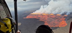
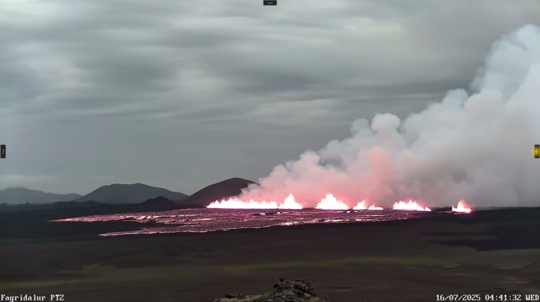
The eruption as seen from the Coast Guard helicopter during a surveilance flight. (Photo: The Icelandic Met Office/Halldór Björnsson)
Updated 11:30, 19 July
Eruption at Sundhnúkur crater row – Ongoing volcanic haze across Iceland
The volcanic eruption on the Sundhnúkur crater row remains active, with gas and volcanic haze spreading widely across the country in recent days. The eruption has remained stable overnight and since yesterday morning. Volcanic activity is focused on 2–3 craters at the central part of the fissure that formed on 16 July, and volcanic tremor remains low and steady.
Air pollution is not confined to areas near the eruption as it can travel long distances and linger over inhabited areas for extended periods.
Volcanic haze has formed under calm wind, humidity, and sunshine, affecting regions such as West Iceland, North Iceland, and the capital region. This pollution appears mainly in two ways:
Gas pollution from sulfur dioxide (SO₂) near the eruption site.
Volcanic haze, formed when SO₂ reacts with moisture and oxygen in the atmosphere, turning into fine sulfate particles (SO₄) that can spread far and persist.
The latest meteorological forecasts indicate light winds from the west or variable directions, allowing pollution and haze to drift widely over South and Southwest Iceland, and even into the highlands in the coming hours.
The public is advised to monitor air quality at air quality (measurements and guidance) and vedur.is (forecasts and maps). Those sensitive to air pollution – such as children, elderly people, and individuals with lung conditions – should take precautions when volcanic haze levels are high.
Further information
Updated at 11:30, 18 July
Status of the eruption and volcanic haze across Iceland
The eruption at the Sundhnúkur crater row continues, though its activity has decreased over the past 24 hours. The main activity is now concentrated at the central part of the fissure, and little to no seismic activity has been measured along the intrusion. Tremor around the eruption sites has also diminished.
No ash has been produced by this eruption, and therefore it has not affected air traffic to or from Iceland.
Volcanic pollution and haze across Iceland – current conditions and advisories
Air pollution from volcanic eruptions mainly occurs in two distinct ways:
Gas pollution from sulphur dioxide (SO₂) rising with the magma, primarily affecting areas near the eruption site.
Volcanic haze forms when SO₂ gas reacts with moisture and oxygen in the atmosphere under sunlight, converting into fine sulphate particles (SO₄). The impact of this haze can be substantial or severe far from the eruption site and may persist for an extended period.
Gas pollution from the eruption has now spread widely across the country and can also be clearly seen over the ocean north and west of Iceland. Volcanic haze has formed in considerable amounts under the current weather conditions, light winds, humidity, and sunshine, and has been observed across large parts of Iceland. The haze has been particularly noticeable in North and West Iceland, where both measurements and visual observations confirm its presence.
People sensitive to respiratory issues, children, and the elderly should avoid prolonged outdoor activity and reduce physical exertion while pollution persists. Healthy individuals may also experience discomfort. It is recommended to close windows and reduce indoor ventilation where applicable, and to air out homes when pollution subsides.
Volcanic haze is widespread, especially in the north and west of the country. The weather forecast predicts light winds in the coming days, with variable wind directions and showers across Iceland. Such conditions favour the persistence of volcanic haze in certain areas.
Further information
Air quality in Iceland – Environment and Energy Agency: data updated every 10 minutes.
Gas pollution forecast – Icelandic Meteorological Office: maps showing areas expected to be affected by sulphur dioxide pollution over the next 48 hours.
Health advisory on volcanic air pollution – Directorate of Health (PDF).
Pollution recording form – Icelandic Meteorological Office: for reporting gas pollution in inhabited areas.
Sentinel-5P web viewer – maps showing the spread of sulphur dioxide pollution over Europe and the Atlantic on a daily basis, based on satellite measurements.
Developments are being closely monitored, and updated data are published regularly on the Icelandic Meteorological Office website.
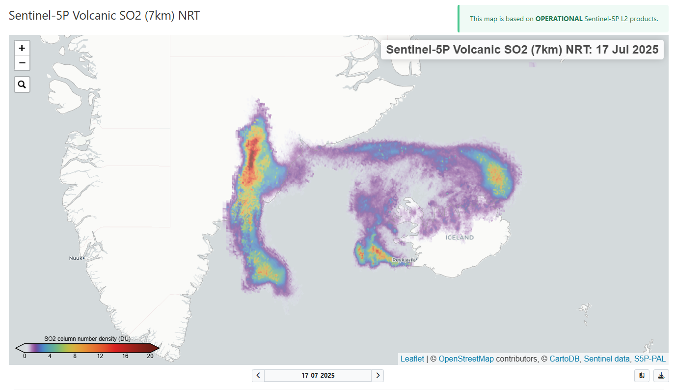
Distribution of sulphur dioxide (SO₂) from the eruption at the Sundhnúkur crater row on 17 July 2025, according to data from the Copernicus Sentinel-5P Mapping Portal.
Updated at 15:50, 17 July
Update from yesterday’s situation: new hazard map in effect
The eruption continues, but activity has decreased and is now confined to around 10 craters
Lava flow is mainly heading towards Fagradalsfjall within foreseeable areas
Low seismic activity and declining tremor
SO₂ pollution has temporarily reached hazard thresholds in some localized areas
Gas dispersal today towards Reykjanesbær, potential pollution in Grindavík tomorrow
Updated hazard map valid until 22 July, no changes to color codes
Eruption status
The eruption at the Sundhnúkur crater row continues, though activity has decreased and is mostly confined to around ten craters. Lava is still flowing, mainly eastward towards Fagradalsfjall, and remains within expected areas.
Seismic activity is low and tremor is declining. Deformation measurements show no significant changes since yesterday. Fog and poor visibility are currently limiting observations of the eruption site.
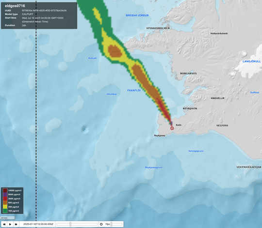
Gas dispersal
Gas dispersal has been widespread, but SO₂ concentrations have only temporarily reached hazardous levels in some localized areas, including Akureyri. Today, 17 July, southeast winds are expected, meaning gas may be carried towards Reykjanesbær and surrounding areas. Tomorrow, light northerly winds are forecast, with potential pollution in Grindavík.
Hazard map and validity period
An updated hazard map has been published to reflect the extent of the lava field. No changes are expected to the color codes while the eruption continues. The Icelandic Meteorological Office (IMO) will continue to closely monitor developments and update information as needed. Gas dispersion forecasts can be found at: https://www.vedur.is/eldfjoll/eldgos-a-reykjanesi/gasmengun/
The IMO’s hazard map has been updated and is valid until 22 July unless significant changes in activity occur.
Main updates and reasons
The main update is that the extent of the lava field has been revised based on aerial mapping, and variable wind directions during the map’s validity period (the next five days) have been taken into account. Changing wind directions mean that gas pollution, ash, and pollution from vegetation fires can spread in all directions from the eruption site. Therefore, the risk from airborne pollution is considered moderate (shown in yellow on the map). It is important for stakeholders to consult IMO’s daily gas dispersion forecasts to assess day-to-day conditions.
Monitoring areas and hazards
No changes have been made to the defined monitoring areas. It is important to clarify that all hazards assessed as higher than very low within monitoring areas are listed, regardless of whether the hazard originates from the current eruption or previous eruptions. The reason lava is specified for Area A (Grindavík and surroundings) is that hazards remain from lava flows from the January 2024 and April 2025 eruptions. Hazards assessed as significant or very significant are highlighted in bold in the list.
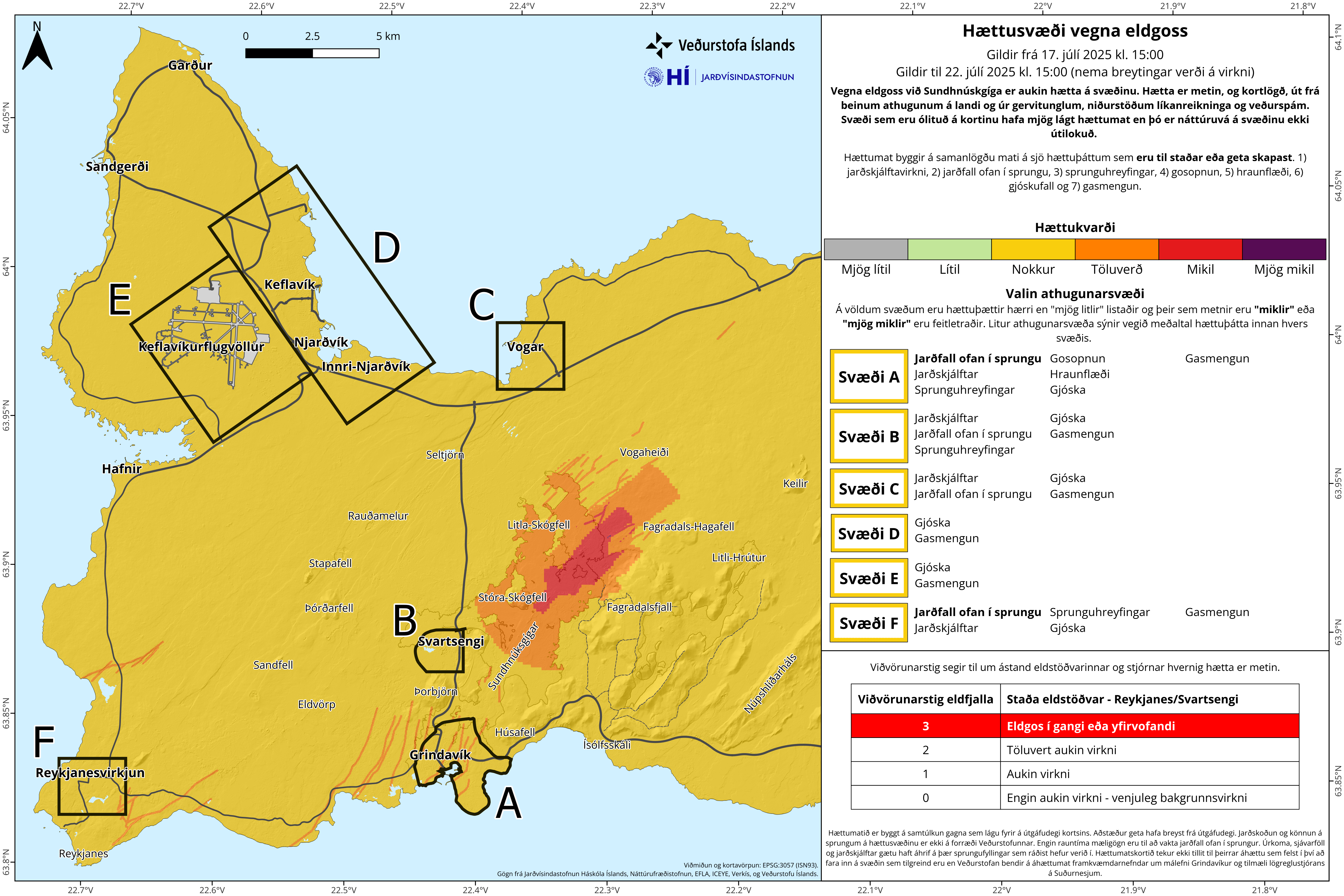
Explanation of terms
Finally, we emphasize that IMO’s hazard assessment describes localized hazards from volcanic activity based on measurements and scientific analysis, independent of what is present in the area. Hazard assessment is not the same as risk assessment, which considers population, activities, or assets in the area.
Pollution associated with the eruption
Pollution associated with the eruption has been notable in recent days. The pollution situation is as follows:
Pollution from vegetation fires is currently considered the greatest hazard in inhabited areas, but such pollution is not detected by SO₂ sensors and therefore does not appear in conventional pollution forecasts
Sulfur dioxide (SO₂) has been measured widely across Iceland, most significantly in West Iceland and also in North and East Iceland
Pollution dispersal depends on prevailing wind directions, so localized pollution levels can change rapidly from day to day
Gas concentrations have generally been decreasing since yesterday morning, but temporary local increases may occur in line with changes in wind and eruptive activity. We therefore stress the importance of consulting IMO’s daily gas dispersion forecasts to assess day-to-day impacts.
This photo was sent to us yesterday by Jón Guðbjörn Guðjónsson, weather observer and postman in Árneshreppur. The image shows volcanic haze over the northern part of Strandasýsla as seen from the weather station at Litlu-Ávík on the afternoon of 16 July.
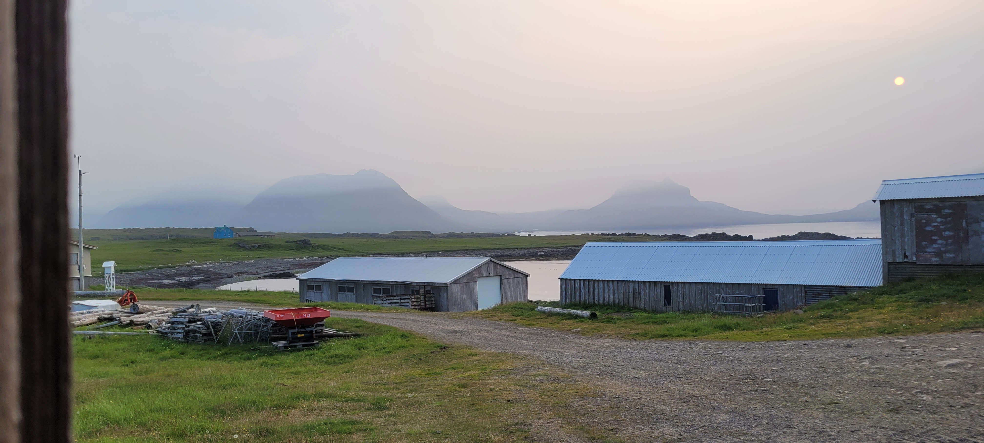
Photo: Jón Guðbjörn Guðjónsson, weather observer in Árneshreppur.
Updated at 17:30
Updated hazard assessment map due to the eruption near Sundhnúkar
The Icelandic Meteorological Office has issued an updated hazard assessment map, valid until 15:00 on 18 July unless activity changes. The alert level for the volcanic system remains at the highest level, 3.
The hazard assessment is based on recent observations and shows the following:
The eruptive fissure has lengthened and now extends farther north than previous fissures since December 2023.
Lava flow continues but has decreased in intensity.
Most of the lava is accumulating east of the fissure and is likely to fill depressions in the area.
Seismic activity has decreased significantly, now measuring only a few small earthquakes per hour.
Gas emissions and wildfires continue to contribute to pollution.
Volcanic tremor and activity
The eruption at Sundhnúksgígaröð continues, but measurements show a decline in its intensity since this morning. The image below shows the development of tremor measurements at seismic station Fad, north of Fagradalsfjall. The lines represent vibration strength across different frequency bands.

Strong tremor was recorded early this morning as the eruption began but has steadily decreased since.
Lava extent
The map below is based on ICEYE satellite observations taken shortly before noon today and shows the extent of the lava from this eruption. At that time, the lava field covered approximately 3.2 km².
The map also shows the estimated location of the eruptive fissure at Sundhnúksgígaröð at around 12:00. Lava has flowed north and northeast from the source, spreading widely across Kálffellsheiði and toward Svartsengi.

The light purple color indicates the new lava field, red lines mark fissures, and the brown grid delineates the observation area and populated areas.
Sulfur dioxide in the atmosphere
Wildfires are currently considered the greatest hazard to inhabited areas, but pollution from these fires is not detected by SO₂ monitors and is not reflected in the current air quality forecast.
The image below shows sulfur dioxide (SO₂) concentrations over Iceland at 13:33 on 16 July 2025, according to Sentinel-5P satellite measurements. Colors indicate pollution strength: light blue for low concentrations, reddish-brown for high concentrations.
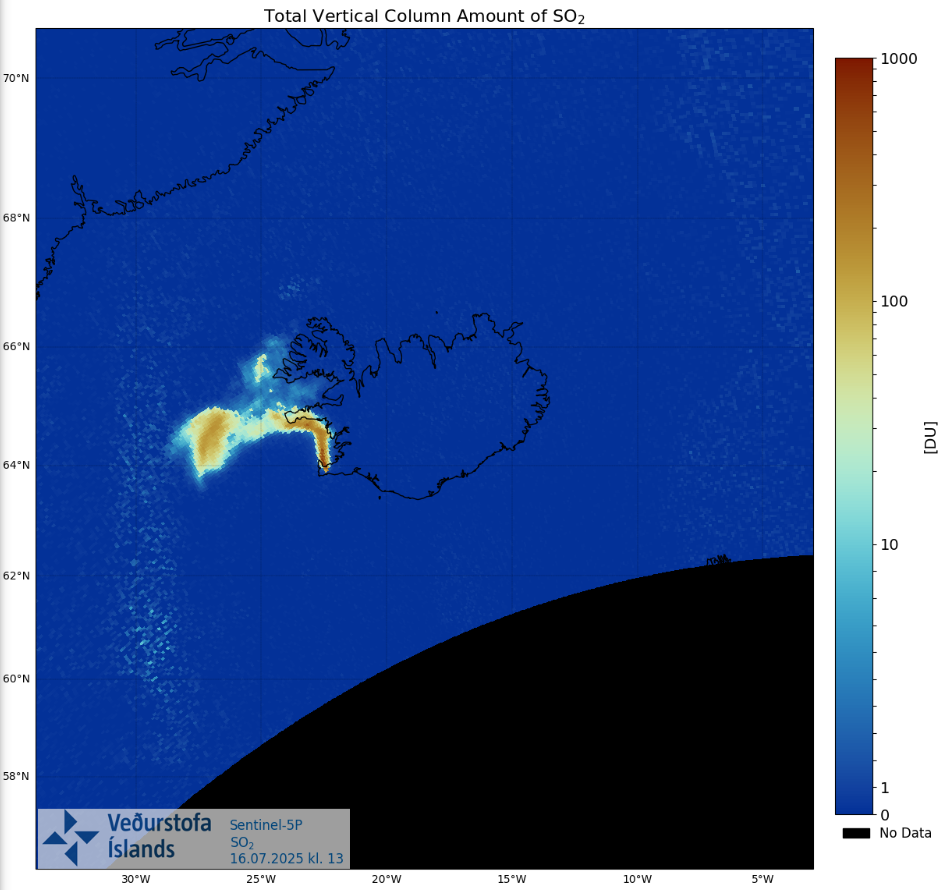
High concentrations are measured over the Reykjanes Peninsula, extending west and southwest over the ocean with the wind.
Hazard assessment for the eruption
Below is the hazard assessment map from the Icelandic Meteorological Office, showing the current assessment of hazards due to the eruption near Sundhnúksgígaröð and how hazard zones are defined based on the current situation. The map describes both existing hazards and those that could develop if activity continues.
All defined observation areas on the map are colored yellow (some hazard), but the map also highlights red zones where the greatest hazards from lava, tephra, and gas pollution could occur.
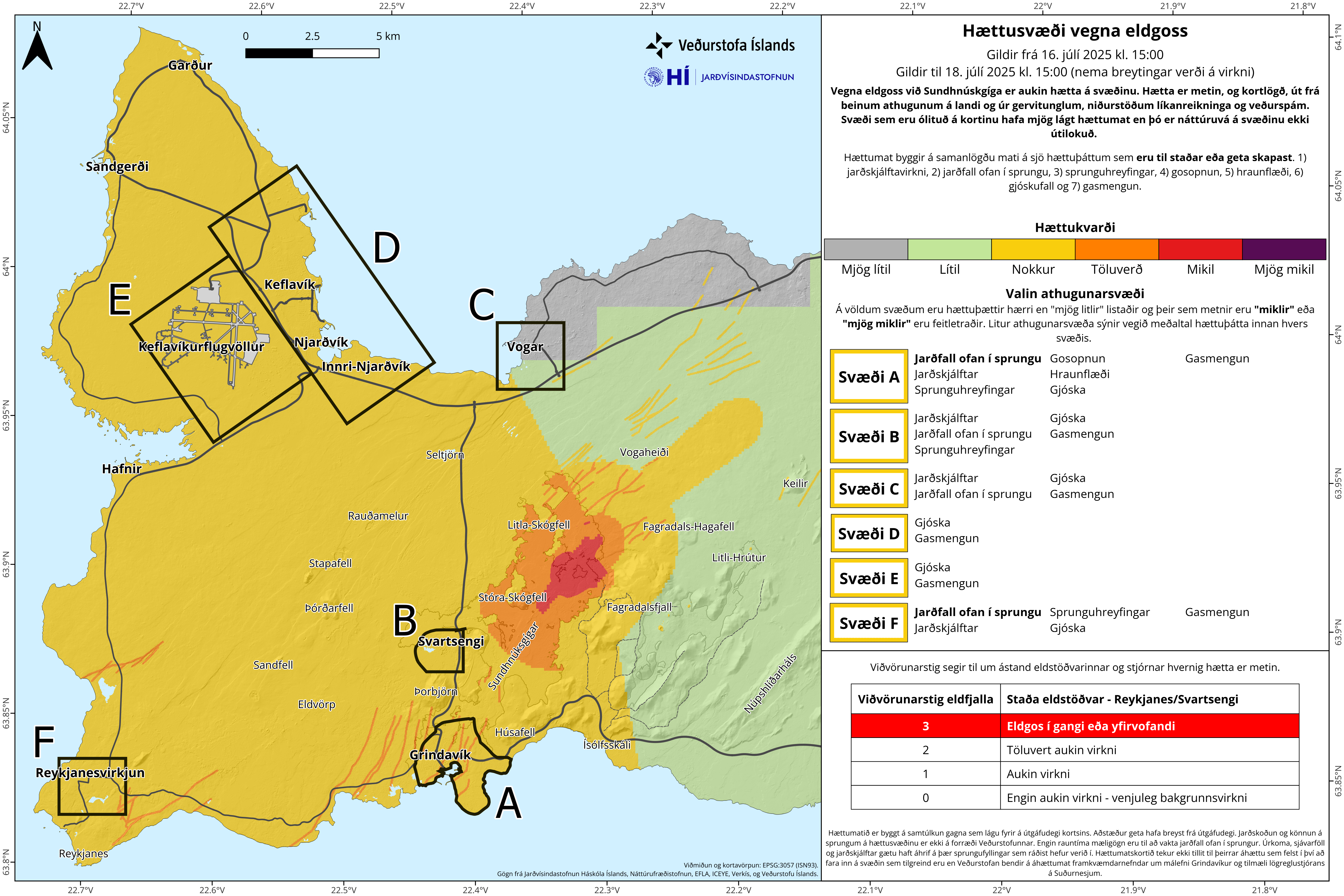
The hazard assessment map will next be updated on 18 July unless changes in activity or weather require earlier action.
The hazard assessment describes the hazards currently present in the area as well as those that could develop if activity continues in the Svartsengi system.
Updated at 12:00
The latest observations show that the eruption is no longer confined to a single fissure. The larger fissure at the Sundhnúkur crater row is estimated to be about 2.4 km long. In addition, a smaller fissure has opened west of Fagradalsfjall and was estimated at about 500 meters in length during an aerial survey by the Icelandic Meteorological Office and the Icelandic Coast Guard.
Updated at 08:45
Seismic activity has decreased during the early morning, but lava flow continues, moving both east and west, with a greater flow to the east. Poor visibility limits the overview, particularly to the west.
So-called “witch’s hair” has been reported drifting in the wind. These are fine glass fibers formed when lava droplets cool rapidly and stretch. They are very light and can travel long distances. Witch’s hair can cause skin and eye irritation, and people are advised to take precautions when outdoors near the eruption site.
High levels of gas pollution are being measured in Reykjanesbær but are decreasing. Residents are advised to stay indoors, keep windows closed, and turn off ventilation systems. It is best to breathe through the nose.
This report will be updated as new data becomes available. An updated hazard map is being prepared and will be published later today.
Updated 5:20
Southeasterly winds today, gas pollution can be expected over Reykjanesbær, Vogar, Sandgerði and Garð.
A link to IMO’s gas dispersion.
Updated at 5:05
The eruptive fissure is approximately 700 to
1000 m long. The fissure has been propagating to the north since the eruption started.
Lava is mostly flowing to the SE and is not
approaching any infrastructure.
Below is a screenshot from a webcamera located
just north of Fagradalsfjall and is looking towards SW.
Updated at 3:56
An eruption has started. The location is southeast of Litla-Skógfell.
Updated at 3:10
The earthquake activity is more intense north of the area where the swarm started.
The hazard assessment has been updated.
Updated
at 2:25
The
earthquakes in the seismic swarm are mostly occurring at 4 to 6 km depth. That
indicates that magma is not moving towards the surface at this point.
Updated
at 2:11
According
to seismicity and real time GNSS data the dike forming below the Sundhnúksgígar
crater row is moving southwards rather than north.
Updated
at 01:55
According
to real time GNSS data the deformation is still minor indicating that the
seismicity is still small compared to previous events.
Updated
at 01:20
Intense
seismic swarm has started on the Sundhnúkur Crater Row and monitoring data
Intense
seismic swarm has started on the Sundhnúksgígar Crater Row and monitoring data
is indicating that an dike intrusion has started. The likelihood of an eruption
remains high while the intrusion is ongoing.
The
seismicity is located between Stóra-Skógfell and Sýlingarfell, a similar
location as previous dike intrusion started on the Sundhnúksgígar Crater Row.
The news will be updated