WESTBOUND. BACK TO YOU. BRIAN. THANK YOU. OUR WILDFIRE COVERAGE CONTINUES THIS MORNING AS A NEW FIRE SPREADS IN SOUTHERN CALIFORNIA. THE KING FIRE IS BURNING RIGHT UP TO I-5 JUST SOUTH OF GORMAN. IT STARTED AROUND ONE THIS MORNING. ITŌĆÖS BURNED NEARLY 500 ACRES. ITŌĆÖS PROMPTED AN EVACUATION WARNING AT A NEARBY RV PARK. ITŌĆÖS CURRENTLY LISTED AT 5% CONTAINED. THE STRETCH OF I-5 WAS CLOSED IN BOTH DIRECTIONS AT LAST CHECK, TWO LANES REMAIN SHUT DOWN. NO WORD YET ON WHAT MAY HAVE STARTED IT. LETŌĆÖS GO TO THE NORTHWEST NOW. GIFFORD. FIRE CONTINUES TO BURN RIGHT NEAR THE CENTRAL COAST. SINCE STARTING 13 DAYS AGO, THAT FIRE HAS BURNED MORE THAN 130,000 ACRES IN SAN LUIS OBISPO AND SANTA BARBARA COUNTIES. CREWS ARE CURRENTLY CONDUCTING A MASSIVE BACK BURN OPERATION, HOPING TO CUT OFF THE FUEL TO THE FIRE. AS OF T
King Fire: Firefighters battle wildfire burning along I-5 north of Los Angeles

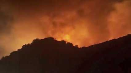
Firefighters scrambled to control a fast-moving wildfire that erupted Thursday morning in hills along Interstate 5 in northwestern Los Angeles County, officials said.The King Fire has swiftly charred about 400 acres of tinder-dry brush in a lightly populated area about 60 miles north of downtown LA.An RV park was ordered to shelter in place and residents of remote homes were under evacuation warnings. The fire was 5% contained as of 6 a.m., according to the Los Angeles County Fire Department.The California Highway Patrol closed some highway lanes as crews battled the flames. Off- and on-ramps were closed at Smokey Bear Road, along with several surrounding roads just north of Pyramid Lake in a mountainous area known for hiking and boating.The blaze is burning a few miles north of the Canyon Fire, which prompted evacuations, destroyed seven structures and injured three firefighters after breaking out Aug. 7. That fire was 97% contained Wednesday after charring about 8 square miles of LA and Ventura counties.The Gifford Fire, CaliforniaŌĆÖs largest blaze so far this year, has scorched at least 204 square miles of Santa Barbara and San Luis Obispo counties since erupting on Aug. 1. It was 41% contained on Wednesday.| MORE | A 2025 guide for how to prepare for wildfires in California | Northern California wildfire resources by county: Find evacuation info, sign up for alertsCal Fire wildfire incidents: Cal Fire tracks its wildfire incidents here. You can sign up to receive text messages for Cal Fire updates on wildfires happening near your ZIP code here.Wildfires on federal land: Federal wildfire incidents are tracked here.Preparing for power outages: Ready.gov explains how to prepare for a power outage and what to do when returning from one here. Here is how to track and report PG&E power outages.Keeping informed when you’ve lost power and cellphone service: How to find a National Weather Service radio station near you.Be prepared for road closures: Download Caltrans’ QuickMap app or check the latest QuickMap road conditions here.See more coverage of top California stories here | Download our app | Subscribe to our morning newsletter | Find us on YouTube here and subscribe to our channel
Firefighters scrambled to control a fast-moving wildfire that erupted Thursday morning in hills along Interstate 5 in northwestern Los Angeles County, officials said.
The King Fire has swiftly charred about 400 acres of tinder-dry brush in a lightly populated area about 60 miles north of downtown LA.
An RV park was ordered to shelter in place and residents of remote homes were under evacuation warnings. The fire was 5% contained as of 6 a.m., according to the Los Angeles County Fire Department.
The California Highway Patrol closed some highway lanes as crews battled the flames. Off- and on-ramps were closed at Smokey Bear Road, along with several surrounding roads just north of Pyramid Lake in a mountainous area known for hiking and boating.
The blaze is burning a few miles north of the Canyon Fire, which prompted evacuations, destroyed seven structures and injured three firefighters after breaking out Aug. 7. That fire was 97% contained Wednesday after charring about 8 square miles of LA and Ventura counties.
The Gifford Fire, CaliforniaŌĆÖs largest blaze so far this year, has scorched at least 204 square miles of Santa Barbara and San Luis Obispo counties since erupting on Aug. 1. It was 41% contained on Wednesday.
| MORE | A 2025 guide for how to prepare for wildfires in California | Northern California wildfire resources by county: Find evacuation info, sign up for alerts
See more coverage of top California stories here | Download our app | Subscribe to our morning newsletter | Find us on YouTube here and subscribe to our channel