HDI or Human Development Index is a composite index that measures the standard of living in given region by taking life expectancy, education attainment and purchasing power into account.
HDI is Human Development Index, it ranks countries based on key indicators of well-being, such as health, education, and income levels.
Hey OP, it might help if you give everybody an idea what HDI stands for.
Not me. I obviously know. But the rest of the common folks…
Since when did half of the Canadian Provinces score less than Minnesota, typically the bright spot in the US?
Unless this is almost live data, and the current American regime has already throttled its vassal state of Canada to servitude, then okay.
Look at the border between the Dominican Republic and Haiti.
These kinds of US maps always look the same.
I don’t think it’s accurate for Brazil
There are more shades of blue on this map than there are on the key
Colorado and Minnesota – home of the famous mass shootings and also highest on index.
Odd.
Also… Hot take but whenever I see such a map I would love to see Canada broken down by municipality. I know Yorkton is not anywhere close to Waterloo…
How is higher in La Pampa than the rest of Argentina? I smell BS
HDI is clearly much higher in regions with a predominantly white population.
This is not just “geography”; it is linked to history, the legacy of colonialism, economic systems, and social inequalities. The sharp contrast between population composition and development clearly highlights the inequalities of the modern world.
Idk, some states should be lower on the ” Hella Dope Index” imo
Is Greenland part of the Americas? If not, you could have left it off the map.
And if it is part of the Americas, you could have estimated its HDI. For lack of an actual rating you could have given it Denmark’s … 0.962
>As in metropolitan Denmark, Greenland has seen significant expansion of the welfare state in the postwar era. Education and healthcare are free, and [LGBTQ rights in Greenland](https://en.wikipedia.org/wiki/LGBTQ_rights_in_Greenland) are some of the most extensive in the Americas and the world. In 1987, the [University of Greenland](https://en.wikipedia.org/wiki/University_of_Greenland) was founded to provide Greenlanders with higher education in their own language and country.
… though Wikipedia also notes high rates of suicide and alcoholism. Not sure if those are factors in HDI.
Greenland should be renamed ‘No Data Land’.
South America’s looks very off/odd.
Way too many regions?
I find it fascinating how consistently development correlates with colder temperatures.
Canada & the northern states vs the southern states, Mexico, & Central America
Argentina & Chile vs Venezuela & Brazil
Finland, Germany, & The Netherlands vs Portugal, Italy, & Spain
South Africa & Botswana vs the DRC & Somalia
Japan & South Korea vs Thailand & Cambodia
New Zealand & Australia vs Papua New Guinea & Polynesia
I mean it isn’t always true, and there are exceptions but it’s very consistent across all continents
Huh, the lighter shades for US states are about where you’d expect but the darker ones are surprising.
Ain’t no way Puerto Rico is better than the Dominican Republic
It’s just funny how many different metrics show the US South lagging behind the rest of the country, but people are too stupid to change anything to better themselves.
Oh well, “thank god for Mississippi, amirite?!” – Louisiana
The curved representation of the map is an artistic choice, but it makes the overall data harder to comprehend. Style and presentation are important, but not if they decrease accessibility of the data being presented.
Minnesota on top as always
HDI on a map like this for the US is a little deceptive. While, understandably it has a purpose it doesn’t shed light on the counties across the United States like what we see similarly in South America and Central America.
California and NY has a massive amount of wealth that uplifts the entire state for example.
But if you go county by county it paints a different picture.
Also, according to this, California doesn’t rank that High on HDI.
I’m honestly surprised the US Deep South is that high.
Georgia has Atlanta to bring it up. North Carolina has RDU and the Research Triangle. The rest of them would be red in my mind.
I downvoted just for the terrible title. HDI=Hard Drive Interface?
I love being a Minnesotan and seeing these maps. Although, I’m entirely confused by the people here who say this state sucks. Taxes are literally the only thing they can name that suck… oh and some grievances over how covid was handled? Cause we had lockdowns to try and save lives, but some small business owners struggled despite having access to massive federal loans.
Does HDI factor in health care?
I grew up in New England and the suburbs of New York and most of the rest of the country seemed noticeably poorer and less developed once I left. Though I have noticed that Colorado, the Pacific Northwest, and Northern California (not Southern CA where I live now) are comparable.
I don’t know how Ontario and British Columbia don’t make the cut though. They seem above the US, more like Northern Europe.
On the one hand, it more or less tracks for states in the US.
But on the other hand, I have a really tough time with the idea that life is better in Tamaulipas than in Yucatan.
The bracketing at the top end of the scale hides the fact that Alberta and Minnesota are only 0.04 apart- 0.947 and 0.951.
This is incredible! By amy chance is it possible to see this at a world level?
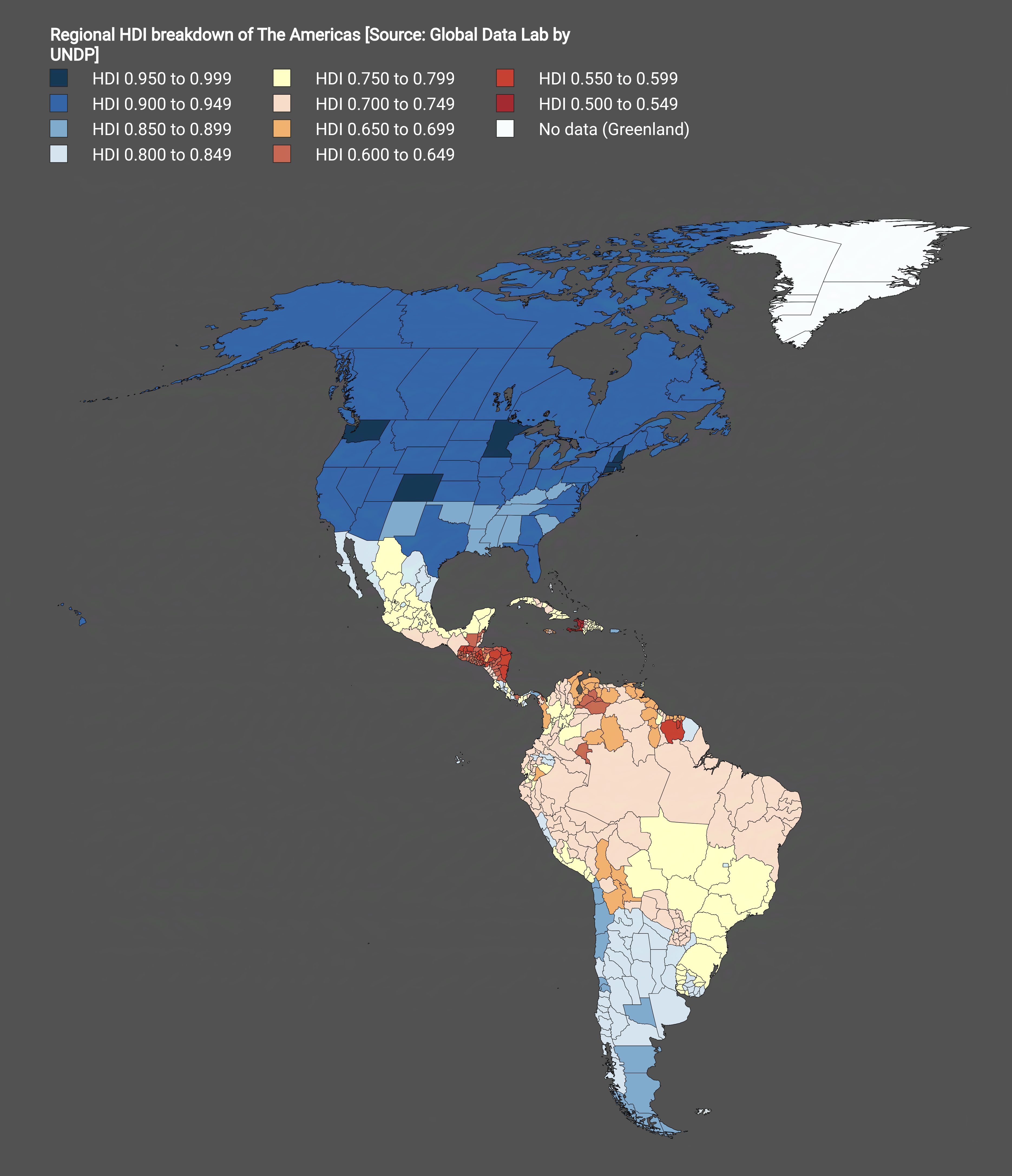
![[OC] Regional HDI breakdown of The Americas](https://www.europesays.com/wp-content/uploads/2025/09/jjngm6emjpqf1-1920x1024.png)
34 comments
Source: [Global Data Lab](https://globaldatalab.org/shdi/table/shdi/BRA/?levels=1+4&years=2022&interpolation=0&extrapolation=0)
Tools: [Mapchart.net](https://www.mapchart.net/)
HDI or Human Development Index is a composite index that measures the standard of living in given region by taking life expectancy, education attainment and purchasing power into account.
HDI is Human Development Index, it ranks countries based on key indicators of well-being, such as health, education, and income levels.
Hey OP, it might help if you give everybody an idea what HDI stands for.
Not me. I obviously know. But the rest of the common folks…
[HDI = Human Development Index](https://en.wikipedia.org/wiki/Human_Development_Index)
Better climate = worse life. Noted
Since when did half of the Canadian Provinces score less than Minnesota, typically the bright spot in the US?
Unless this is almost live data, and the current American regime has already throttled its vassal state of Canada to servitude, then okay.
Look at the border between the Dominican Republic and Haiti.
These kinds of US maps always look the same.
I don’t think it’s accurate for Brazil
There are more shades of blue on this map than there are on the key
Colorado and Minnesota – home of the famous mass shootings and also highest on index.
Odd.
Also… Hot take but whenever I see such a map I would love to see Canada broken down by municipality. I know Yorkton is not anywhere close to Waterloo…
How is higher in La Pampa than the rest of Argentina? I smell BS
HDI is clearly much higher in regions with a predominantly white population.
This is not just “geography”; it is linked to history, the legacy of colonialism, economic systems, and social inequalities. The sharp contrast between population composition and development clearly highlights the inequalities of the modern world.
Idk, some states should be lower on the ” Hella Dope Index” imo
Is Greenland part of the Americas? If not, you could have left it off the map.
And if it is part of the Americas, you could have estimated its HDI. For lack of an actual rating you could have given it Denmark’s … 0.962
>As in metropolitan Denmark, Greenland has seen significant expansion of the welfare state in the postwar era. Education and healthcare are free, and [LGBTQ rights in Greenland](https://en.wikipedia.org/wiki/LGBTQ_rights_in_Greenland) are some of the most extensive in the Americas and the world. In 1987, the [University of Greenland](https://en.wikipedia.org/wiki/University_of_Greenland) was founded to provide Greenlanders with higher education in their own language and country.
… though Wikipedia also notes high rates of suicide and alcoholism. Not sure if those are factors in HDI.
Greenland should be renamed ‘No Data Land’.
South America’s looks very off/odd.
Way too many regions?
I find it fascinating how consistently development correlates with colder temperatures.
Canada & the northern states vs the southern states, Mexico, & Central America
Argentina & Chile vs Venezuela & Brazil
Finland, Germany, & The Netherlands vs Portugal, Italy, & Spain
South Africa & Botswana vs the DRC & Somalia
Japan & South Korea vs Thailand & Cambodia
New Zealand & Australia vs Papua New Guinea & Polynesia
I mean it isn’t always true, and there are exceptions but it’s very consistent across all continents
Huh, the lighter shades for US states are about where you’d expect but the darker ones are surprising.
Ain’t no way Puerto Rico is better than the Dominican Republic
It’s just funny how many different metrics show the US South lagging behind the rest of the country, but people are too stupid to change anything to better themselves.
Oh well, “thank god for Mississippi, amirite?!” – Louisiana
The curved representation of the map is an artistic choice, but it makes the overall data harder to comprehend. Style and presentation are important, but not if they decrease accessibility of the data being presented.
Minnesota on top as always
HDI on a map like this for the US is a little deceptive. While, understandably it has a purpose it doesn’t shed light on the counties across the United States like what we see similarly in South America and Central America.
California and NY has a massive amount of wealth that uplifts the entire state for example.
But if you go county by county it paints a different picture.
Also, according to this, California doesn’t rank that High on HDI.
https://measureofamerica.org/california2021-22/
Nunuvut being so high is surprising
I’m honestly surprised the US Deep South is that high.
Georgia has Atlanta to bring it up. North Carolina has RDU and the Research Triangle. The rest of them would be red in my mind.
I downvoted just for the terrible title. HDI=Hard Drive Interface?
I love being a Minnesotan and seeing these maps. Although, I’m entirely confused by the people here who say this state sucks. Taxes are literally the only thing they can name that suck… oh and some grievances over how covid was handled? Cause we had lockdowns to try and save lives, but some small business owners struggled despite having access to massive federal loans.
Does HDI factor in health care?
I grew up in New England and the suburbs of New York and most of the rest of the country seemed noticeably poorer and less developed once I left. Though I have noticed that Colorado, the Pacific Northwest, and Northern California (not Southern CA where I live now) are comparable.
I don’t know how Ontario and British Columbia don’t make the cut though. They seem above the US, more like Northern Europe.
On the one hand, it more or less tracks for states in the US.
But on the other hand, I have a really tough time with the idea that life is better in Tamaulipas than in Yucatan.
The bracketing at the top end of the scale hides the fact that Alberta and Minnesota are only 0.04 apart- 0.947 and 0.951.
This is incredible! By amy chance is it possible to see this at a world level?
Comments are closed.