Map data sourced from © OpenStreetMap contributors. This artwork is based on data available under the Open Database License, ODbL
by paveloush
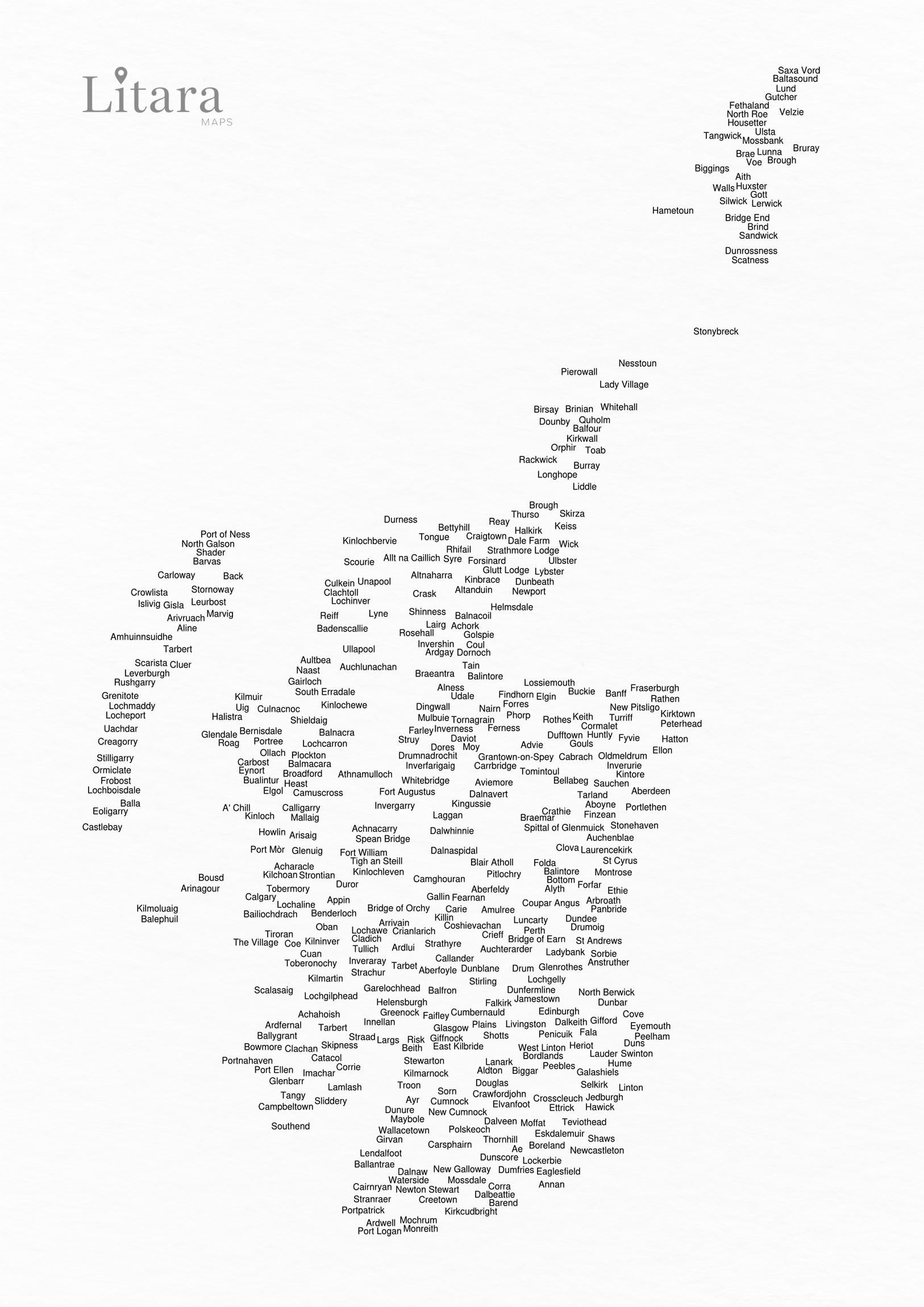
![[OC] I made a typographic map of Scotland using the names of its cities, towns, and villages.](https://www.europesays.com/wp-content/uploads/2025/11/9704ztpmyvyf1-1626x1024.jpeg)
Map data sourced from © OpenStreetMap contributors. This artwork is based on data available under the Open Database License, ODbL
by paveloush
48 comments
Hi everyone! Thanks for checking out my project 🙂
Here’s a little more context on what you’re seeing:
– Think of it less as a traditional atlas and more as a piece of Data Art. The goal was to let the geographic data of Scotland shape the final image.
– It was created using my own custom algorithm with one rule: place each town’s name from the OpenStreetMap dataset at its exact coordinates, but never let them overlap. It means that in dense areas a larger city can create a shadow where smaller neighbours can’t appear. So, **if a beloved town seems to be missing, it’s not an oversight – it’s simply the result of the following the logic**.
For this version, I tried to use English names for consistency being aware of Scotland’s rich linguistic heritage – it would be a project for another day 🙂
Happy to answer any questions.
I love that this method eliminated Airdrie but kept Plains.
Brilliant! It’d be great to see one in Scots and one in Gaelic too
lol some random towns on this map
Funny that it has kept villages over actual towns
Nice. But I think you should have used Embo instead of Coul.
Love a trip to Kilmarnock or Stewarton shore.
Thanks for including Leurbost 👌🏻
“Does it have Brechin?”
“Nope, but it does have Bottom”
Very cool. A strangly big gap between Aberdeen and Ellon though. Would Balmedie or Newburgh have been too long and hit Inverurie?
No sign of Point on Lewis? Exactly how it should be!
Back, a town?!
I like that there’s just randomly someone’s house name in place of actual place names for Eigg 😂
Amulree but no Kenmore, dat be foiten talk dat be!
It’s cool I guess but the accuracy is jarring….
Growing up in Tweedbank I have never travelled through Galashiels South to Selkirk, keep going through JEDBURGH to reach Hawick 🤷♂️
Probably a quirk of font sizes as it should be se of gala and ne of Hawick?
Geographically it’s incorrect.
Very weird not to have Jon o grotes on this map
was the ayrshire coast flooded?
No Stafainn?! How very dare you.
This is cool? Did you use Google maps api to get the names? I only checked out the names in places I know, and ‘Brind’ in Shetland sounds a bit odd. I wonder if this is meant to be ‘Brindister’?.
Drumoig making the cut is wild
You missed out Strathpeffer. You’ve plenty of space for it.
I am devastated my home village Whithorn has been obliterated by your algorithm! It would in all honesty have portrayed a more accurate outline for the southern coast in your data map.
Lendalfoot at last takes its rightful place in history.
I see you left out Irvine.
Good.
Cool, but you missed the town I live in, its the 2nd largest town in Perthshire called Blairgowrie
No Linlithgow might need a history lesson
Is there really a place called “the village” ?
You missed out Inverbervie, Gourdon and Johnshaven. Of course, it would add a long peninsula to the east of the Mearns, but I’m sure we could stick more wind farms on it.
Very good but u missed Pitmedden near ellon Aberdeenshire xx
A blank space just above left of Cumbernauld. Exactly where Kilsyth should be.
Figures.
Gretna and Eastriggs are missing
Methil no more?
Kirkcuddites won’t be amused either….
And omission of Kelty is unacceptable!
Faifley is further south than Greenock 😭
Big up Bridge of Earn
Doesn’t have Kinross. Has Drum, so small that it doesn’t even have a Wikipedia article.
I may be wrong, but I’m fairly sure that Coshievachan and Gallin aren’t actually places in Perthshire unless they’re the names of specific farms, but I’ve never heard of them. And I’ve never even heard of them outwith of Perthshire either. Also Carie and Camghouran aren’t even villages, just the names of the farms on the shores of Loch Tay/Rannoch.
Source: I work all over Highland Perthshire and am familiar with allot of it.
You missed out Invergowrie, beside Dundee towards Perth.
No drum … 🙁
Omg! Fala mentioned
Merged Islay Kintyre and arran all together 🙁
Disappointed that there’s no Inchnadamph. Disgraceful.
Turriff being directly under New Pitsligo is so odd to see
How did you get to Arran without that entire coastline?
Seamill, Ardrossan, Saltcoats, Stevenston, Kilwinning and Irvine – gone?
Editing to add, Risk??? Never heard of it 😆
Jamestown but no Inverkeithing? Jamestown is barely a house!
Dalwhinnie and Dalnaspidal showing here! This is where I was brought up. Dalwhinnie is better known, but Dalnaspidal used to be a small village. Probably a hamlet in definition. Used to have a train station. Got told lots of stories from trains not stopping at the station sometimes due to the gradient. It would just go by slowly and you had to jump off/on. To some train drivers taking a rifle with them and bagging a deer when the train was slow, then collecting it later when they were dropped off on the return run. Lots of characters, great stories, and of course there was the legendary Dalnaspidal dram!
Quick check of Caithness….no Latheron, Dunnet or John O’Groats….but there’s “Dale Farm” and “Strathmore Lodge” 😂🤷
Plains rather than Airdrie or Coatbridge is an interesting choice.
Comments are closed.