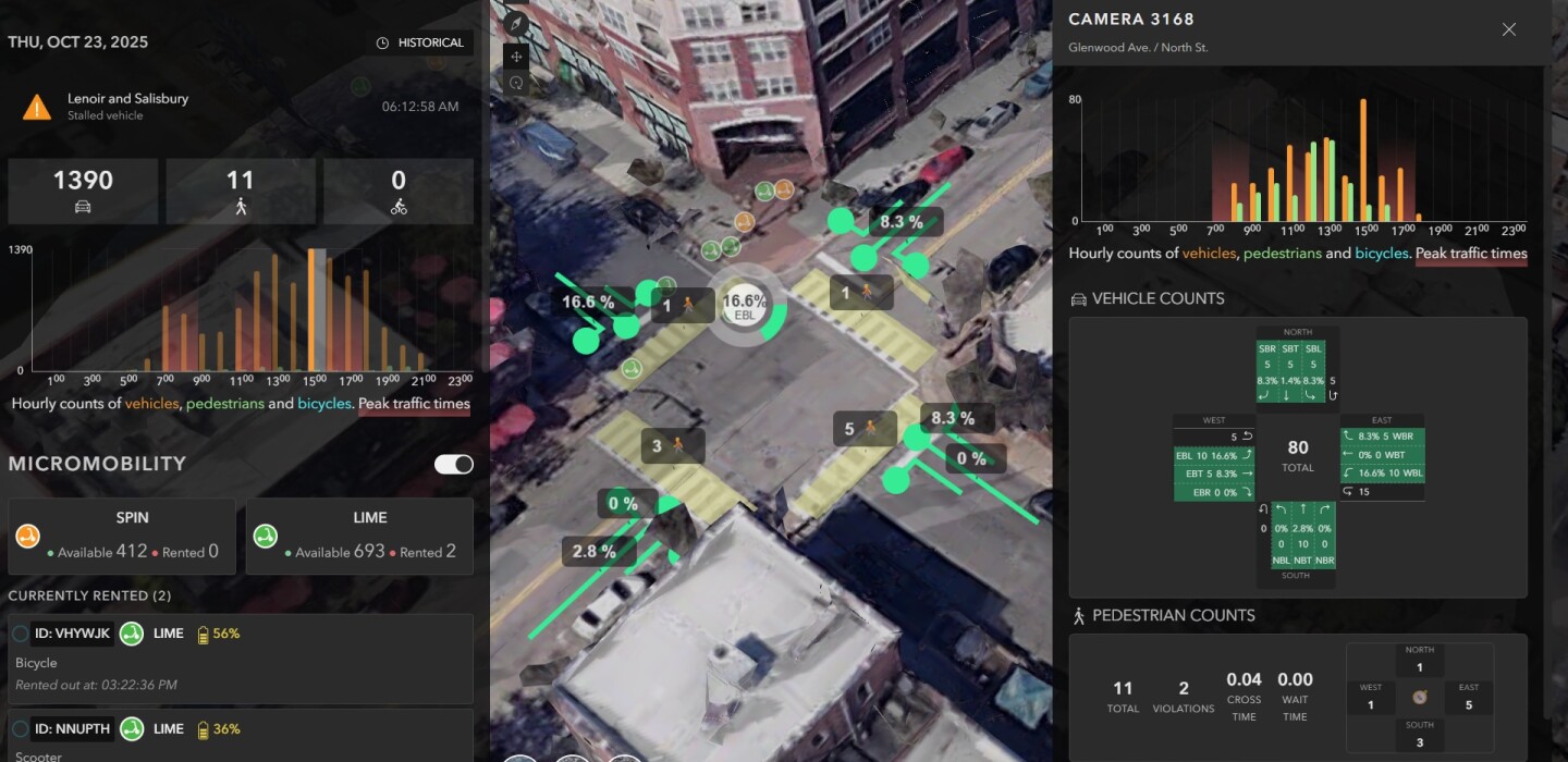
At any given time, there are about a dozen intersections in Raleigh, N.C., capturing detailed traffic data which is then treated with AI technology to offer new, real-time insights.
In a pilot that began about two years ago, technology and transportation officials in North Carolina’s capital city have been experimenting with applying AI technology to small groups of traffic cameras, James Alberque, Raleigh IT manager, said. The data is put into the city’s mapping technology, offering findings like how many vehicles are at an intersection at any given time, with the goal of leveraging that data to both improve traffic movement and safety for pedestrians and cyclists.
Raleigh is partnering with tech companies like NVIDIA, Microsoft and Esri, the GIS and mapping technology giant, to bring together the right pieces of AI, computing and mapping to advance its insights into signal timing, predictions related to what generates traffic problems, and giving priority to certain vehicles like fire trucks or transit buses.
“Can we use AI to better understand our city?” Alberque said. “And on that, we think we’re squarely there. We think we’re in the space of understanding. And once we do the understanding, can we apply the analysis?”
Today, the city sends vehicle turning movement counts and other data for a selective set of intersections, generally about 10 to 12, to its digital twin. The technology moves about once a week to select another dozen intersections. The data is archived and viewable on a dashboard.
“We have some technical limitations around compute, the amount of processing that we’re doing,” Alberque said, adding, the city has not “made a significant investment in hardware. And so, our capacity is 10 to 12 cameras at a time.”
The process starts with capturing image data coming from traffic cameras at intersections. The city has about 200 of these.
“Historically, that has been piped to our traffic management center,” Alberque said, noting these monitors are generally only useful to the traffic officials in the room watching them. However, the AI technology is able to categorize the vehicles according to type, such as car, truck or delivery vehicle. It also tracks volume within the particular travel lanes, and turning data. The turning movement data collected by the pilot can replace the manual counting process, which can be labor-intensive and only represents a point in time.
These new tranches of data and the wider understanding of mobility — built in part by existing GIS foundational technology — are helping to move cities and regions into the next chapter of “intelligent transportation systems,” known in the industry as ITS.
“There’s been a whole bunch of parallel innovations in a whole bunch of key areas,” Alison Brooks, research director of smart cities strategies, public safety at IDC Government Insights, said, pointing out the ability to combine video, lidar, radar, vehicle telemetry and more “into a unified stream, versus how they used to be kept in their own sort of silos.”
Then comes the added layer of conducting real-time analytics driven by AI and machine learning, which allows officials to predict and “scenario plan,” Brooks said. “So that’s where you get the more predictive kind of modeling.”
In recent years cities have been more easily operationalizing digital projects, enabled in part by what Brooks calls, “under the waterline, non-sexy, tech innovations,” as tech companies provide easy-to-use solutions like digital twins, or new visualization tools. But data has also become more interoperative and AI-ready.
“The conjunction of all of the sort of edge processing and sensors, all of the video sources, and the traffic data in a model that is at the same time democratized means that you can actually — leveraging the AI on top of that, and the automation capabilities on top of that — you’re able to run like 300 simulations on what might happen, in a given certain circumstance,” Brooks said.
It’s allowed city transportation systems to become much more proactive than reactive.
“You can get what’s going on, on a Friday in Raleigh if there’s X weather, and there’s these five events, and it’s the first week of September,” she said. “You‘re also able to get much more insights from a particular car, people, a road, pedestrians, or whatever, and you’re kind of able to get a little bit more of a nuanced scenario planning around what’s happening at those different altitudes.”
This is the kind of future officials like Alberque have in mind for Raleigh, but the city is taking its time, validating results, building confidence.
“We want to slow-walk this with our partners in transportation, around making sure that they’re comfortable with it. This technology is something you really can’t stub your toe on,” Alberque said. “We’re in that understanding and analyzing phase, which is very much human-in-the-loop. In our estimation, we’re very early on in this.”