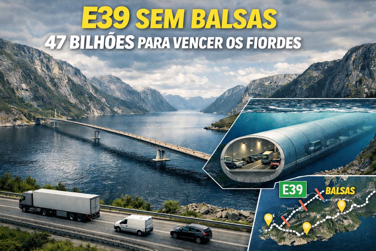
On the west coast of Norway, the government plans to transform the E39 highway In a continuous link between the south and north of the country, replacing the current ferry crossings with a sequence of advanced bridges and tunnels. Today, the journey of about 1.100 kilometers takes around 21 hours because of the fjords and mandatory stops, although in a straight line it could be done in approximately 14 hours.
To change this scenario, the country is implementing the largest infrastructure plan in its history, estimated at 47 billion dollars. More than just shortening travel time, the project plans to transform the highway in a modern transport corridor, capable of integrating isolated communities, facilitating the flow of goods and creating a new global showcase for Norwegian engineering.
The fjord coast and the E39 challenge.
The so-called E39 coastal highway winds along the country’s coastline, a region known for harboring some of the most stunning landscapes on the planet, with over a thousand fjords formed by the action of ancient glaciers.
See also other features
Liquid membrane creates continuous, seamless waterproofing, eliminates leaks in slabs and roofs, and is already replacing traditional systems in large areas.

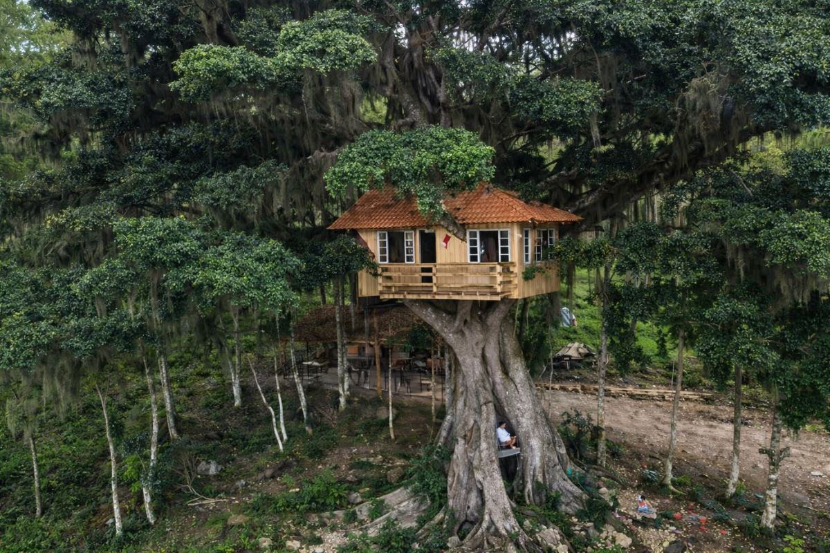
Farmer builds house alone 11 meters high in a centuries-old fig tree, works at night, uses wood, avoids nails, fulfills childhood dream and transforms a city in Santa Catarina into a tourist attraction.
These mistakes are very costly for Brazilians when drilling an artesian well.

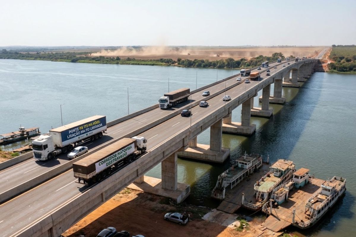
A R$172 million bridge connects Maranhão and Tocantins in record time, eliminates the need for ferries, unlocks the Matopiba corridor, and transforms Estreito and Aguiarnópolis into a strategic hub for national agribusiness logistics.
The largest of them reaches approximately 200 kilometers in length and more than 1 kilometer in depth, which makes any crossing project an extreme challenge.
Along its current route, between the southernmost and northernmost parts of Norway, the E39 crosses several fjords and currently relies on eight ferry crossings. Each stop involves waiting, boarding, and disembarking, adding hours to the journey and creating vulnerability in case of bad weather, queues, or operational disruptions. The government’s plan plans to transform the highway to completely eliminate these ferries and ensure a continuous flow of vehicles.
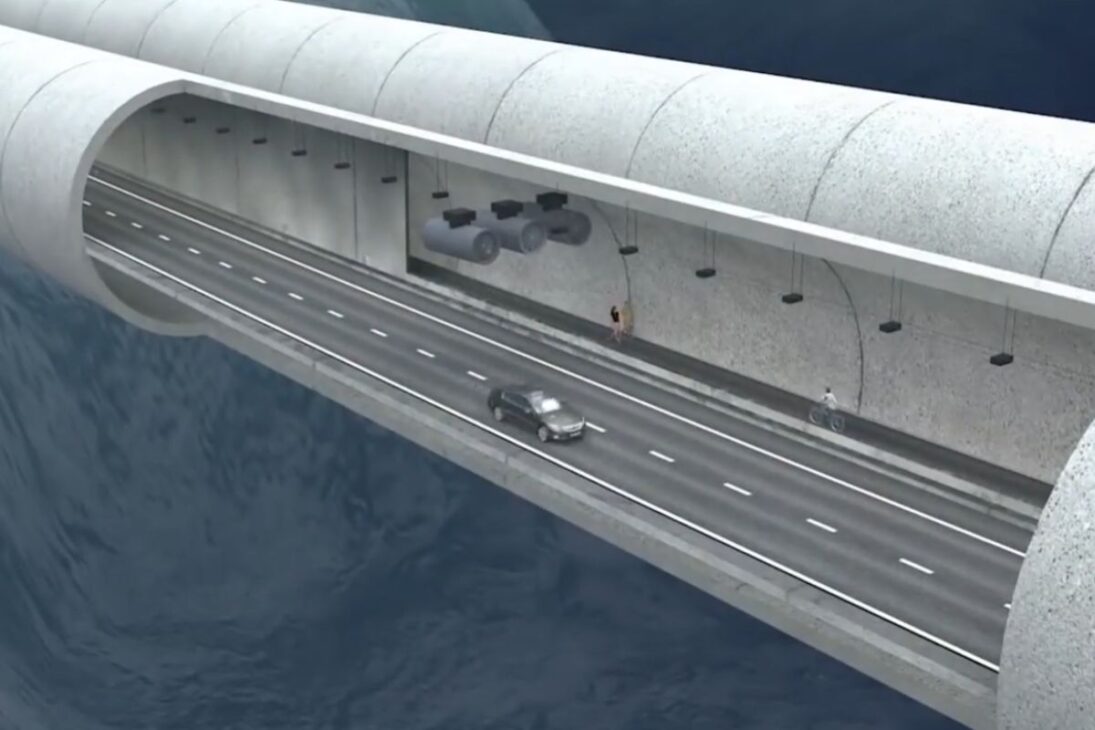
The first major step in the project is Rogfast, an underwater tunnel that will connect the E39 to the Stavanger region. It will be approximately 27 kilometers long, with a section that could reach a depth of 390 meters, which should make it the deepest road tunnel and one of the largest in the world when completed.
Rogfast will consist of two parallel tunnels, with connecting access points every 250 meters and emergency exits every 500 meters, in addition to shoulders and security cameras along the entire route. Along the way, the structure will also connect to a small archipelago of approximately 5 km², integrating islands and just over 500 inhabitants with the rest of the country, something that reinforces how the government… plans to transform the highway also as a tool for regional inclusion.
Construction on Rogfast began in 2018, was halted in 2019 for project review, and resumed in 2021, with completion scheduled for 2026 and an estimated cost of $2 billion.
Floating bridges and submerged tunnels to overcome giant fjords.
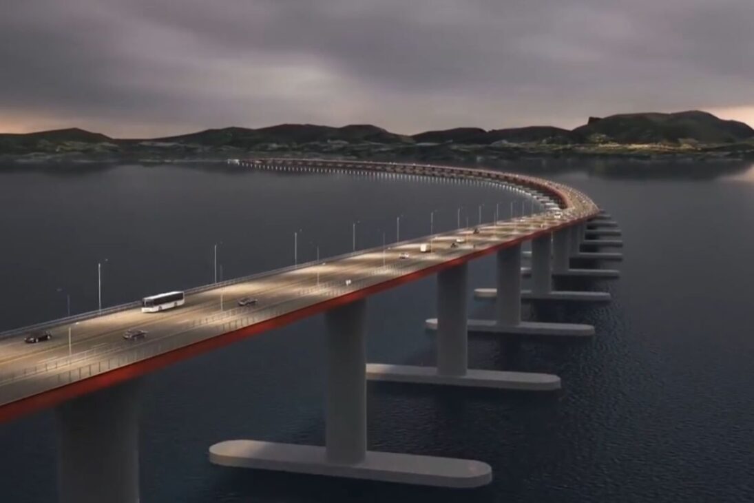
If Rogfast is already impressive, other sections of the plan demand even bolder solutions. South of a large coastal city, a fjord up to 10 kilometers wide, with stretches of 5 kilometers and a depth of about 600 meters, challenges any conventional structure. For it, engineers are studying a floating bridge anchored to the banks, capable of adapting to the extreme depths and sea conditions.
In another crossing, over the Sula Fiorden, two ideas are on the table. The first is a suspension bridge with three towers in sequence, one anchored to the seabed about 400 meters below the waterline and the other two connected to the coast. The alternative is a floating, submerged tunnel with two parallel tubes, suspended by highly resistant cables fixed to the bottom of the fjord, allowing ships to pass on the surface without interrupting vehicle traffic.
Another planned section requires an underwater tunnel of approximately 16 kilometers, also complemented by a bridge approximately 2 kilometers long, creating a combination of structures to overcome depths and widths that vary according to each fjord. In all these solutions, the objective is the same: plans to transform the highway along a continuous route, even where geography seemed to prevent any direct connection.
The largest fjord and the most ambitious part of the project.
The most complex aspect of the plan lies in crossing the largest and deepest fjord in Norway and Europe, which stretches for over 200 kilometers, is approximately 3,7 kilometers wide, and reaches a depth of 1,3 kilometers at its deepest point. The region also experiences heavy ship traffic, forcing engineers to plan for minimum clearances of 400 meters wide, 70 meters above the waterline, and at least 20 meters below to ensure the safe passage of vessels.
For this section, several alternatives are being analyzed. One of them is a suspension bridge approximately 3.700 meters long, almost twice the length of the world’s longest current bridge, which would require towers nearly 500 meters high. Another option is a floating bridge, which would need to have movable or adjustable parts whenever large ships approached, adding enormous operational complexity.
There are also studies underway for a floating and submerged tunnel without cables attached to the bottom, supported by floating blocks on the surface, allowing ships to pass over it without interfering with the structure. A hybrid solution, combining a floating bridge with a submerged tunnel, is also under evaluation. This type of transition between emerged and submerged structures already exists in connections such as the bridge between Denmark and Sweden and the crossing between Hong Kong and Macau, but never in a scenario as deep and complex as this one.
A world leader in engineering and infrastructure.
Although other countries such as Italy, the United States, and Japan have already considered projects to connect areas with rugged terrain, none have progressed as far as the Norwegian plan for its fjord coast. Work associated with the E39 has been making progress and is expected to extend until around 2035, when the government hopes to have the route fully connected.
The $47 billion investment is expected to be recouped primarily through toll collection along the new coastal highway. In parallel, engineering teams are working with strong environmental and safety concerns, planning structures that can withstand strong winds, currents, heavy ship traffic, and the harsh conditions of the North Sea. The ambition is that the project… plans to transform the highway not just in a faster road, but in a global infrastructure model for extreme regions.
Ultimately, the new E39 promises to shorten distances, bring cities closer together, integrate islands, and show the world that it’s possible to combine pristine landscapes with some of the most daring engineering solutions ever conceived.
And you, do you believe it’s worth investing all that money in a project that… plans to transform the highway The E39 is on one of the most impressive routes on the planet, or do you think there are simpler and cheaper alternatives to improve mobility in the region?