IOPS provides a comprehensive satellite imagery analysis package combined with an intelligent satellite imagery data fusion service to support high-value satellite applications. Their solutions transform raw satellite data into actionable insights through advanced processing, analysis, and reliable ground infrastructure.
Image Processing Subsystem (IPS)
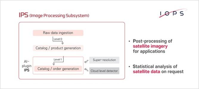
The Image Processing Subsystem (IPS) is designed for the post-processing of satellite imagery to support various downstream applications. IPS enhances image quality, extracts useful information, and enables advanced analytical workflows for Earth observation and remote sensing missions.
Key Features of IPS
Ø Satellite Imagery Post-Processing
IPS performs post-processing of satellite imagery, including image enhancement, correction, and preparation for application-specific use cases.
Ø Satellite Imagery Data Fusion
The subsystem supports data fusion from multiple satellite sources, improving accuracy and analytical value through integrated imagery datasets.
Ø Statistical Analysis Services
IPS provides statistical analysis of satellite imagery data on request, enabling detailed insights and data-driven decision-making.
Ø Application-Ready Outputs
Processed imagery is delivered in formats optimized for mapping, monitoring, and analytical applications.
4.5m Antenna System
The 4.5m Antenna System is a high-performance ground station component supporting reliable satellite communication and data reception. It plays a key role in enabling efficient satellite imagery acquisition and downstream processing.
Key Features of the 4.5m Antenna System
Ø S-Band Data Transmission and Reception
Supports stable S-band communication for command, telemetry, and data exchange.
Ø X-Band Data Reception
Enables high-speed X-band data reception for large-volume satellite imagery downlink.
Ø High-Precision Tracking
Designed for accurate satellite tracking, ensuring consistent signal quality during data reception.
Ø Reliable Ground Infrastructure
Provides robust and continuous support for satellite imagery acquisition as part of an integrated ground system.
Integrated Satellite Imagery Solutions
By combining a powerful satellite imagery analysis package, advanced satellite imagery data fusion service, and reliable antenna systems, IOPS delivers end-to-end solutions for satellite data reception, processing, and analysis.
If you are looking for satellite imagery analysis package and satellite imagery data fusion service, you can find them at IOPS.
Click here if you are interested in IOPS products.
View more: Advanced Satellite Imagery Analysis and Data Fusion Services
IOPS provides a comprehensive satellite imagery analysis package combined with an intelligent satellite imagery data fusion service to support high-value satellite applications.
IOPS provides a comprehensive satellite imagery analysis package combined with an intelligent satellite imagery data fusion service to support high-value satellite applications.
This release was published on openPR.