Strong winds and extreme heat have brought down trees, cut power and fanned vegetation fires across parts of New Zealand, as temperatures surged into the high 30s and multiple weather warnings were issued.
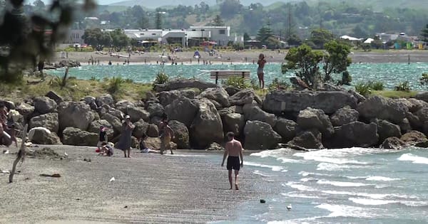
Napier and Hastings both topped 36C, leading the national temperature spike, with Gisborne at 33.2C, Christchurch at 31.2C, and Whang─ürei and Tauranga falling just shy of 30C.
MetService said Napier recorded its second highest January temperature since records began in 1973, while Kerikeri and Whitianga recorded 32.7C and 30.5C, the highest January temperatures for both stations since records began in 1978 and 1990 respectively.
Heat alerts ŌĆö first introduced in 2021 ŌĆö were in effect for Whang─ürei, Whitianga, Tauranga, Whakat─üne, Rotorua, Taup┼Ź, Gisborne, Napier, Blenheim, Kaik┼Źura, Christchurch and Timaru.
Multiple strong wind and heavy rain warnings were in place, with galeŌĆæforce winds caused damage in several centres. In Christchurch, strong winds blew an oak tree onto a house in the suburb of Papanui.
Bill and Christine Hainstock had spent Sunday morning in the garden of their home, picking flowers and watering plants, before heading inside for a coffee. Moments later, there was what Christine describes as an “almighty bang”.
“I walked into the room next door to the kitchen, and I couldnŌĆÖt see out of the windows for leaves,” she said.
An 80ŌĆæyearŌĆæold oak tree outside their home had been uprooted by strong winds, crashing down onto the front of the house and damaging the garage and spouting, as well as cutting the power.
“It decided it liked my house better than standing up straight,” Bill joked.
The couple, both in their 80s, told 1News they felt incredibly lucky they had stepped inside when they did.
“It was horrendous, but IŌĆÖm so pleased neither of us were killed. WeŌĆÖre going to buy a Lotto ticket,” Christine said.
Fallen trees also disrupted travel, with NZTA reporting sections of SH73 in Canterbury and SH6 on the West Coast were blocked. The agency urged people to take extra care, particularly those driving highŌĆæsided or towing vehicles and motorcyclists.
Fire and Emergency NZ responded to vegetation fires in Hurunui and Central HawkeŌĆÖs Bay. Both blazes were brought under control, with crews continuing work to fully extinguish them.
Fire crews say the Hurunui blaze was sparked by an old burnŌĆæoff that had been smouldering underground for months before strong winds caused it to flare up.
“TheyŌĆÖre a bit like a h─üngi pit ŌĆō theyŌĆÖll just cook away, and once theyŌĆÖre exposed, that happens,” Assistant Commander Graeme Knight told 1News, gesturing to the smoking hillside behind him.
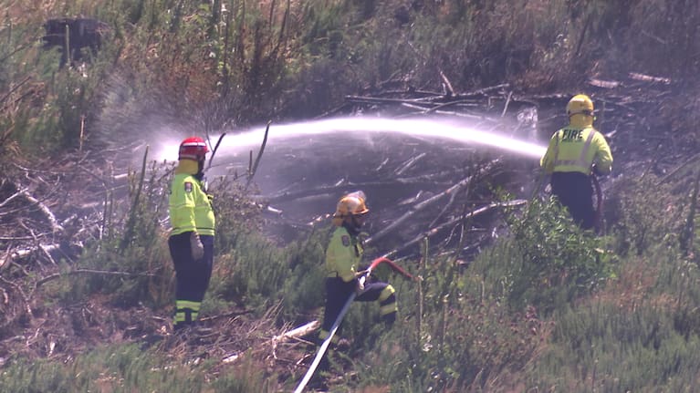
“It looks like an old burn from probably six to eight months ago thatŌĆÖs just had the top collapse. With the strong winds, a few embers were blown out onto the hillside.”
Crews arrived to extreme conditions, with winds so strong firefighters struggled to stand, but were able to contain the fire quickly with the help of green vegetation.
Localised flooding and downed trees closed roads around the Queenstown Lakes District, prompting warnings for motorists to avoid unnecessary travel.
HawkeŌĆÖs Bay Civil Defence said it was closely monitoring conditions and urged people to stay informed as hot, windy weather increased fire risk.
Further severe weather was forecast, particularly in the South Island. OrangeŌĆælevel heavy rain warnings were in place for most of Westland and Fiordland north of Doubtful Sound until 9am Sunday, and for the Westland ranges and headwaters of the Canterbury lakes until 9pm.
OrangeŌĆælevel strongŌĆæwind warnings applied to inland and highŌĆæcountry Canterbury overnight, and came into effect early Sunday morning for Marlborough and much of the Wellington region, with forecasters warning of severe gale northwesterlies and damaging gusts.
Thundery rain was possible in the Buller and Grey districts, while Westland and Fiordland could expect periods of heavy rain and isolated thunderstorms. Rain and scattered showers were also forecast for Canterbury, Otago and Southland, with thunderstorms possible in the Queenstown Lakes District.