Published on
February 4, 2026

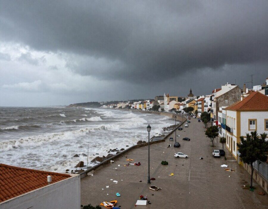
Portugal and Spain have issued an urgent travel alert as Storm Leonardo sweeps across the Iberian Peninsula, bringing with it intense rainfall, powerful winds, and significant flooding risks. Starting in Portugal, the storm is set to deliver strong gusts reaching up to 95 km/h, with the potential for coastal flooding and damage to infrastructure. As the storm progresses into Spain, particularly Andalucía, severe weather conditions are expected to worsen, prompting red and amber alerts in high-risk areas. Authorities are warning travelers to stay informed and take necessary precautions, as the combination of heavy rain and strong winds could disrupt transportation, cause property damage, and lead to hazardous conditions throughout the region.
Storm Leonardo Brings Heavy Rain and Strong Winds to Portugal and Spain, With Warnings in Place
Storm Leonardo is making its way across the Iberian Peninsula, with heavy rain and strong winds forecasted to impact both Portugal and Spain. The Portuguese Institute of the Sea and the Atmosphere (IPMA) issued an alert, warning that the storm would affect mainland Portugal from Tuesday afternoon and persist until Saturday, while Spain, particularly Andalucía, will begin feeling the storm’s full impact on Wednesday. The storm is expected to bring intense rainfall and powerful wind gusts, reaching speeds of up to 75 km/h (47 mph) along Portugal’s southern coast and as high as 95 km/h in mountainous regions.
Though not as severe as the 200 km/h winds brought by Storm Kristin last week—which left devastating effects in central Portugal, including six fatalities—Storm Leonardo is still a considerable threat. Forecasters warn that the combination of heavy rainfall and strong winds could result in flooding and infrastructure damage in several areas.
In Spain, Andalucía braces for what is expected to be a fierce weather event. The provincial governments of Cádiz and Málaga have issued a “red alert” for parts of their regions, while other areas in Andalucía have been put under yellow and amber weather warnings. The towns of Grazalema in Cádiz, along with the Ronda mountains and Campo de Gibraltar, are predicted to bear the brunt of the storm’s strongest impacts.
Portugal, however, is set to face the initial impacts of Storm Leonardo. The storm will first hit the Algarve and Baixa Alentejo areas, beginning on Tuesday afternoon. These areas will experience consistent rain and winds that could gust up to 75 km/h along the southern coast and 95 km/h in higher altitudes.
Advertisement
Advertisement
Authorities are particularly concerned about the expected rainfall, which could worsen existing conditions in regions already dealing with swollen rivers and flooded waterways following the devastation caused by Storm Kristin. The effects of Leonardo are expected to spread throughout the rest of Portugal by Wednesday, bringing rain and strong winds to additional regions across the country.
The IPMA has issued several warnings in response to the storm’s anticipated impact. Yellow alerts, indicating a lower level of concern, have been placed on Faro, Setúbal, and Beja due to the expected persistent rainfall, which is forecasted to begin on Tuesday at 6 p.m. and continue until 3 p.m. on Wednesday. There will be additional rainfall overnight on Wednesday, from 9 p.m. to 9 a.m. on Thursday. Other areas, including Santarém, Lisbon, Leiria, Castelo Branco, Coimbra, and Portalegre, are also under yellow alerts for rain on Wednesday night into Thursday morning.
In addition to these rain warnings, orange alerts have been issued for coastal areas, including parts of the Algarve, Porto, Faro, Setúbal, Viana do Castelo, Lisbon, Leiria, Beja, Aveiro, Coimbra, and Braga. These regions are at risk from powerful waves, some of which could reach up to 11 meters in height. A snow warning has also been raised for several northern districts, including Viseu, Porto, Guarda, Vila Real, and more, where heavy snowfall is expected to blanket the region.
As the storm progresses, authorities are urging residents and travelers to take all necessary precautions. Flooding remains a significant concern, especially in areas with already swollen rivers, while strong winds could lead to tree falls, power outages, and damage to infrastructure. Local authorities are actively monitoring the situation, advising citizens to avoid unnecessary travel, stay indoors, and be prepared for sudden changes in weather conditions.
The storm’s impact on infrastructure could be significant, with the potential for road closures, disrupted public transportation services, and coastal flooding. Coastal communities, in particular, are being urged to take extra caution as high waves and storm surges may impact shorelines, leading to the risk of flooding and property damage.
As the storm continues its march through the Iberian Peninsula, residents are encouraged to stay informed by following official weather updates from both the Portuguese and Spanish meteorological services. Emergency services in both countries are on high alert, ready to respond to any flooding, damage, or emergencies caused by Storm Leonardo.
Despite the storm’s intensity, it’s worth noting that Storm Leonardo’s winds are not expected to match the catastrophic strength of those from Storm Kristin. However, its combination of heavy rain and strong winds, particularly in already affected areas, poses a significant risk to both public safety and infrastructure.
This storm is a reminder of the volatile weather conditions that can affect the Iberian Peninsula during the winter months. While authorities are taking measures to minimize disruption, the public must remain vigilant. Residents of Portugal and Spain should be ready for the storm’s progression over the coming days, and all necessary preparations should be made to safeguard homes, property, and communities against potential flooding and wind damage.
Portugal and Spain have issued an urgent travel alert as Storm Leonardo brings intense rain, strong winds, and flooding risks across the Iberian Peninsula. With severe weather expected to disrupt travel and cause damage, authorities urge travelers to stay informed and take precautions.
The storm is expected to last until Saturday, with its intensity gradually waning as it moves across Spain. However, the risk of localized flooding and hazardous weather will remain a concern throughout the duration of its impact. As always, safety should be the top priority for residents and travelers across the region.