 Motorists navigate a flooded N.C. Highway 12 on Pea Island during a rainstorm in July that prompted state transportation officials to temporarily close the only route in or out. Photo: NCDOT
BUXTON — When the only highway on your island is situated between an ocean and a sound, and is built essentially at sea level, water on the road from storm surge comes with the territory. But even weather-savvy Outer Bankers were taken aback by a rain deluge in July that in minutes flooded N.C. Highway 12 with so much water that vehicles were swamped, stalling out and driving off the pavement.
National Park Service officials notified North Carolina Department of Transportation staff for this area, and they were already aware of flash flood warnings that had been issued by the National Weather Service. They were prepared for possible flooding, but no one expected the speed and volume of water that fell on the remote stretch of Pea Island National Wildlife Refuge just south of the Basnight Bridge.
“We really didn’t know if, where, or how much,” explained NCDOT Division Engineer Ronnie Sawyer. “We certainly didn’t know it was going to get to the point where we felt like we needed to close the road.”
 North Carolina Department of Transportation Deputy Division 1 Engineer Marshall Gill and Bobby Outten, the Dare County manager and attorney, speak Tuesday during a public meeting at the Fessenden Center in Buxton. Photo: Catherine Kozak
Speaking during a community meeting held last week in Buxton to discuss the highway closure, Sawyer described the rainstorm as “an extreme circumstance” that would be difficult or near impossible to plan for. In the 32 years he has worked for the department, he added, he couldn’t recall a time when N.C. 12 had to be closed because of rainwater.
But rainstorms are different now. With climate change, the warmer air holds much more moisture. Flash flooding is when the water level rises significantly in a short period of time. It can happen in minutes or hours, and it doesn’t just happen where there are creeks and rivers, or only during tropical storms, for that matter.
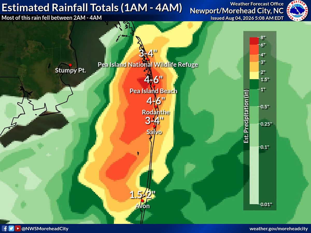 An estimated 6 to 10 inches of rain fell between July 21 and July 24, according to the National Weather Service, which created this graphic.
“Where we are, since we’re so close to sea level and flat, it’s almost flash ponding,” Erik Heden, Warning Coordination Meteorologist at the National Weather Service Weather Forecast Office in Newport told Coastal Review in a later interview.
“It does happen quick,” said Heden. “There’s the flash part, but it just doesn’t go anywhere, and it’s just not really moving.”
About 6 to 10 inches of rain fell between July 21 and July 24, he said, with the peak on the 24th. Rain fell at a rate up to 2 inches an hour, with reports of a foot or more of water on N.C. 12, leading to the road being closed from the bridge to Rodanthe.
 “We certainly didn’t know it was going to get to the point where we felt like we needed to close the road,” said NCDOT Division 1 Engineer Ronnie Sawyer Tuesday during the meeting in Buxton. Photo: Catherine Kozak
According to the nearest rain gauge in Manteo, 10.49 inches fell over five days. The average rainfall total for July is 5 to 6 inches.
Heden said the storm was what is called “training,” with multiple rain cells moving back and forth over the same location. “Usually, you get an inch or two of rain, it’s a good thunderstorm, and then it moves on about its merry way,” he said. “When you have something stalled out like that, it allows the storm to move or train over the same area over and over again.”
What’s important is that people pay attention to weather reports about potential impacts of systems in their area, and not just during tropical storms, Heden said. It’s easy to dismiss warnings when those prior ones don’t happen. But sometimes predictions aren’t possible until a couple of days before the event.
“We had very strong language actually leading up to that,” he said, and a flood warning was issued for a Level 3 out of 4 risk. “So just because it’s not tropical-related doesn’t mean it can’t be bad.”
That risk level means a greater than 40% chance of flash flooding, he said. A Level 1 is at least a 5% chance. Level 2 is a 15% chance. And a high-risk Level 4 carries a 70% chance.
“If I told you had a 40% chance to win the lottery,” he added, ”then you’re going to go buy a ticket.”
Sawyer, with NCDOT, said the department had issued multiple alerts and posted messages on road signs and social media, but with the unpredictable nature of the storm, it was not possible to provide enough warning to people traveling on N.C. 12 through Pea Island. And he vowed to continue to work closely with the U.S. Fish and Wildlife Service on drainage improvements in the the refuge.
Dare County manager Bobby Outten also said the county would discuss details about whether pumping would be practical if needed.
“I can assure you we do not want to close the road,” Sawyer said. “It’s a whole can of worms.”